Wayground logo

Free Printable Worksheets

Font size

S
M
L
XL
Worksheets

Weather and Climate Review

Total questions: 67

Worksheet time: 1hrs 24mins
Name
Class
Date
1.
Because the earth is spinning on its axis, the global winds appear to curve. This is known as the __________ ________.
a)
Coriolis Effect
b)
Greenhouse Effect
c)
Climate Effect
d)
Atmosphere Effect
2.
What kind of weather is usually associated with a high pressure system?
a)
Sunny weather
b)
Precipitation (rain, snow, etc.)
3.
Rain, snow, sleet, and hail are all forms of _____.
a)
precipitation
b)
condensation
c)
evaporation
d)
climate
4.

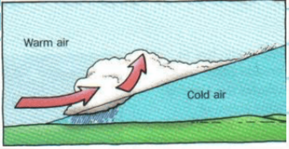
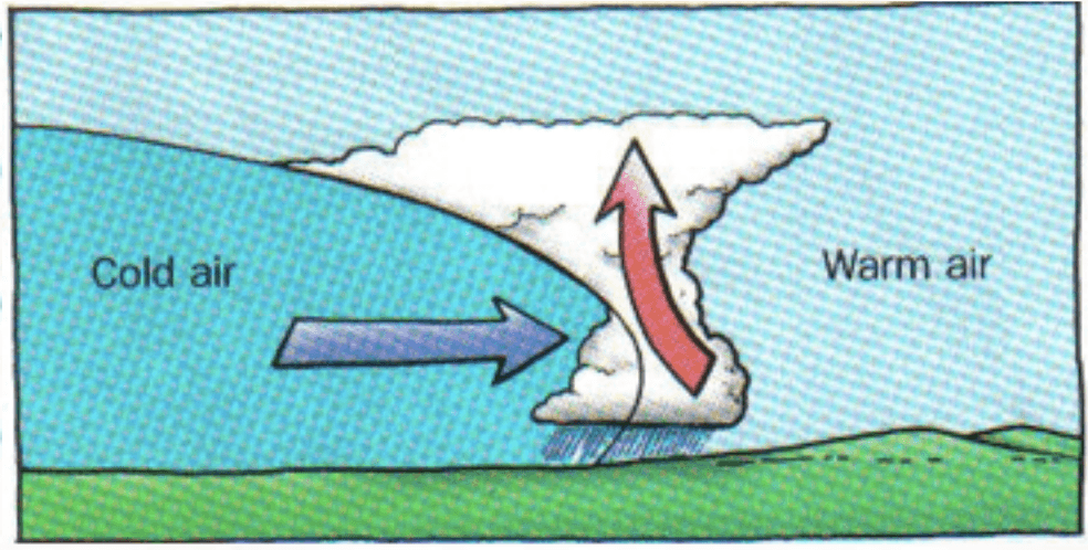
Name that front.

a)

Cold Front

b)

Warm Front

c)

Stationary Front

d)

Occluded Front

5.

Name that front.

a)

Cold Front

b)

Warm Front

c)

Stationary Front

d)

Occluded Front

6.

Brings some clouds and gentle rains.

a)

Cold Front

b)

Warm Front

c)

Stationary Front

d)

Occluded Front

7.

Cold dense air slides underneath warm air. The warm air is forced up, cools, and condenses.

a)

Cold Front

b)

Warm Front

c)

Stationary Front

d)

Occluded Front

8.
In a high pressure systems
a)
there are few clouds because the air in moving downward
b)
there are many clouds because the air is very humid
c)
there are few clouds because the air is moving outward
d)
there are many clouds because the air is moving upward
9.
When two air masses meet, what happens?
a)
The weather changes and precipitation usually occurs.
b)
wind
c)
water
d)
volcano
10.

What type of weather will you see along a cold front?

a)

Thunderstorms

b)

Sunny skies

c)

Gentle rain

d)

No weather

11.

What kind of weather happens along a Warm Front?

a)

Thunderstroms

b)

Days of Rain!

c)

Nothing

d)

Wind

12.
What type of front may be rainy or foggy for several days?
a)
Cold
b)
Stationary
c)
Occluded
d)
Warm
13.

The temperature and humidity in an air mass stays about -

a)

different

b)

the same

c)

100* C

14.

An air mass gets its ____________ and __________ from the water or land it came from.

a)

humidity, temperatue

b)

size, shape

c)

color, weight

d)

weather, animals

15.
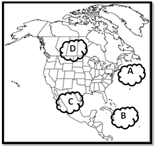
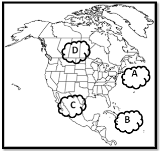
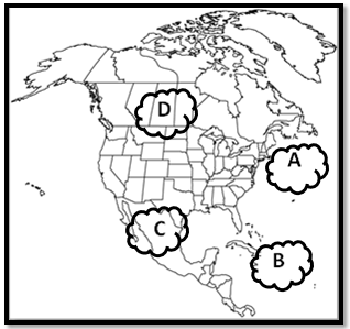
Which type of air would you find at air mass A?
a)
cold, dry
b)
warm, humid
c)
warm, dry
d)
cold, humid
16.

In the continental US, air masses travel consistently in the same direction. Which way do they travel?

a)

Northeast to Southwast

b)

Southeast to West

c)

East to West

d)

West to East

17.

Pick the TRUE answer in the following about how air masses move:

a)

Air masses move at an estimated 56 km/hr in dry weather and 34 km/hr in cold humid weather.

b)

Prevailing Westerlies are the only type of wind that moves air masses in the continental US.

c)

Prevailing westerlies and jet streams move air masses from east to west in the continental US.

d)

Jet streams and prevailing westerlies work together to move air masses from west to east in the continental US.
18.
Which type of air would you find at air mass B?
a)
cold, dry
b)
warm, humid
c)
warm, dry
d)
cold, humid
19.

Which type of air would you find at air mass C?

a)

mT

b)

mP

c)

cT

d)

cP

20.

Which type of air would you find at air mass D?

a)

mT

b)

mP

c)

cP

d)

cT

21.
When a cold air mass moves into a warm air mass, it will get colder and we will have severe weather. What type of front is this?
a)
warm front
b)
cold front
c)
occluded front
d)
stationary front
22.
A maritime polar air mass is 
a)
Dry and Cold
b)
Wet and Cold
c)
Wet and Warm
d)
Dry and Warm
23.
What's the humidity and temperature of a continental tropical air mass?
a)
Wet and cold
b)
Dry and warm
c)
Wet and warm
d)
Dry and cold
24.
What's the humidity and temperature of a maritime tropical air mass?
a)
Wet and cold
b)
Dry and warm
c)
Wet and warm
d)
Dry and cold
25.
A wet and cold air mass would be a...
a)
Maritime polar
b)
Continental polar
c)
Maritime tropical
d)
Continental tropical
26.
A dry and cold air mass would be...
a)
Maritime polar
b)
Continental polar
c)
Maritime tropical
d)
Continental tropical
27.

The map of North America shows the source region of an air mass forming mostly over Mexico. This air mass originating over Mexico is classified as

a)

continental polar

b)

continental tropical

c)

maritime polar

d)

maritime tropical

28.

An air mass entering Alaska from the northern Pacific Ocean would most likely be labeled on a weather map as

a)

cT

b)

cP

c)

mT

d)

mP

29.

Base your answer on the map, which shows the position of the jet stream relative to two air masses and a low-pressure center (L) over the United States. What is the difference in the air temperature and humidity between the cP and mT air masses?

a)

The cP air mass is warmer and less humid.

b)

The cP air mass is colder and more humid.

c)

The mT air mass is warmer and more humid

d)

The mT air mass is colder and less humid.

30.

Which geographic region is the most common source region for the mT air masses that move into New York State?

a)

northern Canada

b)

Arctic Ocean

c)

southwestern United States

d)

Gulf of Mexico

31.

Tornadoes occur when a very cold, dry air mass meets a very warm, wet air mass. Which two air masses would most likely form a tornado when they meet?

a)

cP and cA

b)

cT and mP

c)

cP and mT

d)

mP and mT

32.

Because water ___________, ocean currents have a great effect on climate.

a)

cannot hold heat

b)

hold large amounts of heat

c)

moves more slowly than air

d)

stays colder than air

33.

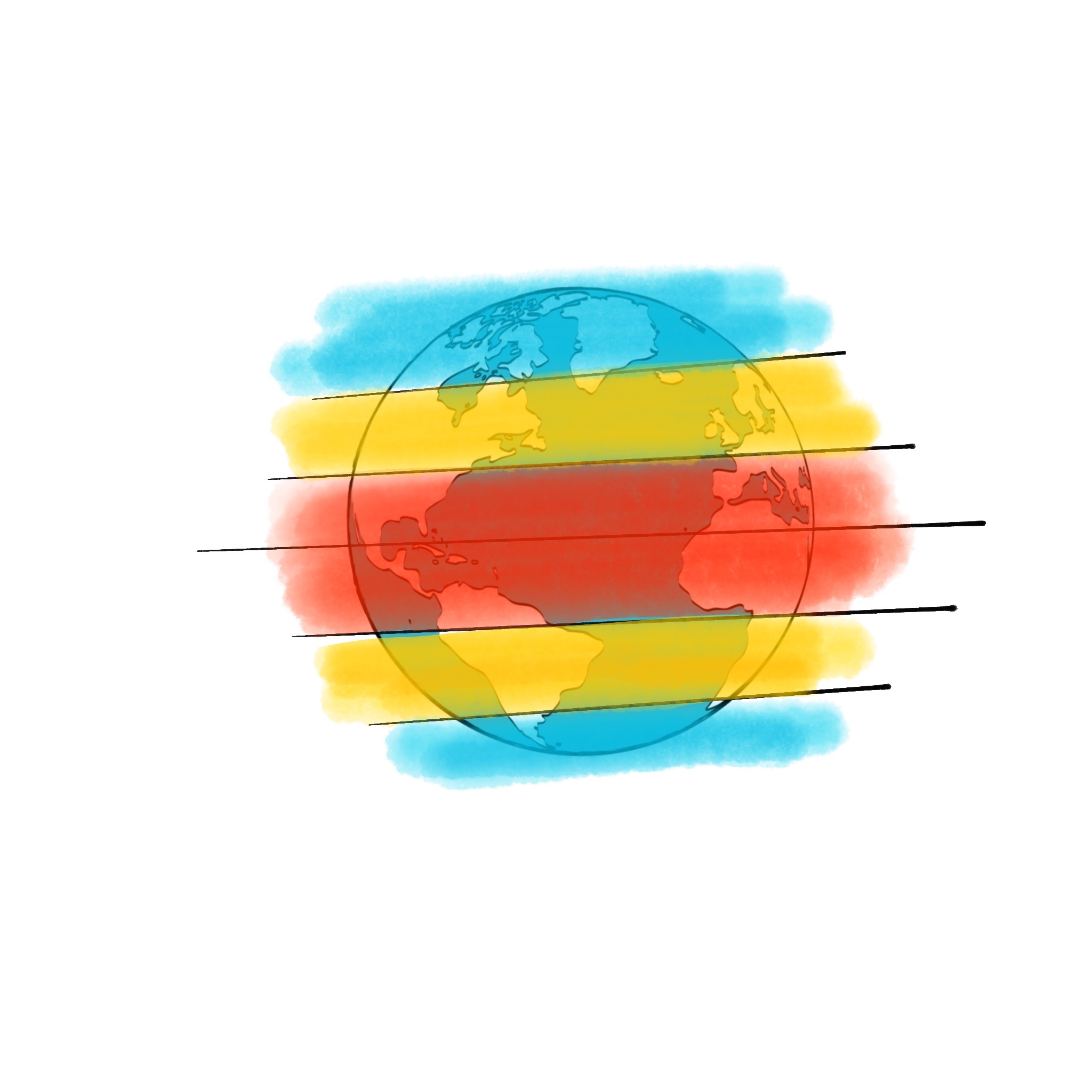
Look at the picture, which climate zone is in red?

a)

Temperate zone

b)

Polar zone

c)

Tropical zone

34.
What are characteristics of Dry Climates?
a)
Annual precipitation is more the the potential loss of water by evaporation
b)
The annual precipitation is less every year.
c)
The annual precipitation is less than the potential loss of water by evaporation.
d)
The annual precipitation is more every year.
35.

Why are tropical climates so wet?

a)

The sunlight is very direct & strong

b)

High pressure zones

c)

Low pressure zone

d)

The sunlight is very indirect & weak

36.

Why are dry climates so dry?

a)

The sunlight is very direct & strong

b)

High pressure zones

c)

Low pressure zones

d)

The sunlight is very indirect & weak

37.
What is the climate of the top of a mountain like as compared to the bottom of the mountain?
a)
warmer
b)
cooler
c)
drier
d)
wetter
38.
Which of these is NOT a factor that determines the climate of a place?
a)
latitude
b)
wind patterns
c)
longitude
d)
elevation
39.
Which sentence best describes the relationship between elevation and air temperatures?
a)
 LOWER elevation = COLDER temperatures
b)
HIGHER elevation = COLDER temperatures
c)
HIGHER elevations = WARMER temperatures
d)
There is no relationship
40.
What are the 3 major climate zones in order from equator to the poles?
a)
polar, temperate, tropical
b)
tropical, temperate, polar
c)
temperate, polar, tropical
d)
temperate, tropical, polar
41.
Climates are classified according to which two major factors?
a)
elevation & precipitation
b)
latitude & temperature
c)
elevation & latitude
d)
precipitation & temperature
42.
The map shows average annual temperatures in degrees fahrenheit across the United states.
Which climate factor is most important in determining the pattern shown in the eastern half of the United States?
a)
Ocean currents
b)
Mountain barriers
c)
Elevation above sea level
d)
Latitude
43.
Arrows on the map represent ocean currents.
These ocean currents affect the climate of city x by 
a)
decreasing the average annual clod cover
b)
decreasing the average annual evapotranspiration
c)
increasing the average annual temperature
d)
increasing the average annual air pressure
44.
Compared to an inland location of the same elevation and latitude, a coastal location is likely to have
a)
warmer summers and cooler winters.
b)
warmer summers and warmer winters.
c)
cooler summers and cooler winters.
d)
cooler summers and warmer winters.
45.
What is the name of the warm ocean currents that flows along the east coast of the United States?
a)
California Current
b)
Florida Current
c)
Labrador Current
d)
North Pacific Current
46.
The diagram below shows the position of the cities of SEattle and Spokane, Washington. Both cities are located at approximately 48° North latitude, and they are separated by the Cascade Mountains. 
How does the climate of Seattle compare with the climate of spokane?
a)
Seattle- hot and dry
Spokane- cool and humid
b)
Seattle- hot and humid
Spokane- cool and dry
c)
Seattle- cool and humid
Spokane- warm and dry
d)
Seattle- cool and dry
Spokane- warm and humid
47.
Base your answer to the following question on this map which shows an imaginary continent on Earth. Arrows represent prevailing wind directions. Letters A through D represent locations on the continent. Locations A and B are at the same latitude and at the same elevation at the base of the mountains.
Over the course of a year, compared to location B, location A will have 
a)
less precipitation and a smaller temperature range.
b)
less precipitation and a greater temperature range.
c)
more precipitation and a smaller temperature range.
d)
more precipitation and a greater temperature range. 
48.
This cross section shows the prevailing winds that cause different climate on the windward and leeward side of this mountain range. 
Compared to the climate conditions on the leeward side of this mountain range, the conditions on the windward side are usually
a)
cooler and wetter
b)
cooler and drier
c)
warmer and wetter 
d)
wartmer and drier
49.

The leeward side is also known as the:

a)

wet side

b)

rainy side

c)

arid side

50.

The windward side of the mountain is __________

a)

Wetter and colder

b)

Drier and hotter

c)

Wetter and Hotter

d)

Drier and colder

51.

As the wind flows down the leeward side of the mountain, the air becomes

a)

colder and drier

b)

wetter and colder

c)

warmer and drier

52.

Which side of the mountain has more rain?

a)

Windward

b)

Leeward

c)

Mountain

d)

Ocean

53.

The primary factor that controls the climate zones

a)

elevation

b)

solar time

c)

latitude

d)

longitude

54.

Which temperature zone gets the MOST direct energy from the sun?

a)

tropical

b)

polar

55.

Why does NY have a lower average temperature than Miami?

a)

Miami is close to the water

b)

Miami has a high elevation

c)

Miami has a lower latitude

56.

Average temperatures are warmer in Austin, Texas than in Seattle, Washington. Why?

a)

Austin, Texas is closer to the South Pole.

b)

Seattle is closer to the Equator.

c)

Seattle is a higher longitude.

57.
In the water cycle, the sun provides
a)
energy for water to evaporate from oceans, lakes and rivers.
b)
water for evaporation to happen. 
c)
energy to produce electricity. 
d)
water for condensation to happen. 
58.
During which stage do clouds form?
a)
condensation
b)
evaporation
c)
precipitation
59.
What is it called when plants give off water vapor as a waste product?
a)
condensation
b)
evaporation
c)
sublimation
d)
transpiration
60.

The image shows various stages in the water cycle. During which stage does water flow back towards the sea as runoff?

a)

W

b)

X

c)

Y

d)

Z

61.
What is A?
a)
Evaporation
b)
Condensation
c)
Precipitation
d)
Runoff
62.
What is B?
a)
Evaporation
b)
Condensation
c)
Precipitation
d)
Runoff
63.

According to the ESRT, which material would require the most heat energy to increase the temperature of 1 gram of the material one Celsius degree?

a)

Ice

b)

Water

c)

Basalt

d)

Granite

64.

Which material would require the greatest amount of heat energy to raise its temperature from 5oC to 10oC? [Refer to the Earth Science Reference Tables.]

a)

Iron

b)

Lead

c)

Granite

d)

Dry Air

65.

If the same amount of heat is added to each sample, the smallest change in temperature will occur in the

a)

Iron

b)

Dry Air

c)

Granite

d)

Water

66.

What would heat up the fastest if left out in the sunlight on a clear, summer day?

a)

Liquid Water

b)

Dry Air

c)

Lead

d)

Granite

67.
A high specific heat means...
a)
It heats up quickly with energy added
b)
It requires more energy to change temperature