wayground logo

Free Printable Worksheets

NEW

Font size

S
M
L
XL
Worksheets

Erosion and Deposition Review

Total questions: 43

Worksheet time: 26mins

Name
Class
Date
1.
What is released when waves break?
a)
sand
b)
energy
c)
wave trains
d)
water
2.
Which way do sand dunes move?
a)
up & down
b)
to the west
c)
toward the sea
d)
in the direction of the wind
3.
What is the force that moves glaciers?
a)
ice
b)
wind
c)
gravity
d)
energy
4.
What are two kinds of glaciers?
a)
moraine and continental
b)
continental and alpine
c)
valley and mountain
d)
till and stratified drft
5.
Columns of rock that were connected to the mainland
a)
sea caves
b)
sea stacks
c)
sea arches
d)
sea cliffs
6.
big holes in the rock at the bottom of sea cliffs
a)
sea caves
b)
sea stacks
c)
sea arches
d)
sea cliffs
7.
form when waves cut through the sea cave
a)
sea caves
b)
sea stacks
c)
sea arches
d)
sea cliffs
8.
sediment that feels like powder
a)
desert pavement
b)
dunes
c)
loess
d)
deflation 
9.
Mounds of sand left by the wind
a)
desert pavement
b)
loess
c)
dunes
d)
deflations
10.

_____________________ is the movement of soil and rock by wind, water, ice, and gravity.

a)

Weathering

b)

Erosion

c)

Deposition

11.

______________________ occurs when eroded materials stop moving and begin to build up.

a)

Weathering

b)

Erosion

c)

Deposition

12.
The four agents of erosion are water, wind, gravity, and _____. 
a)
groundwater
b)
abrasion
c)
ice
d)
acid rain
13.
Off-shore deposits can create _____. 
a)
Rivers
b)
Streams
c)
Barrier Spits
d)
Beaches 
14.
A slow rapid mass movement can cause trees and fence posts to lean downhill. What is this called? 
a)
Slump
b)
Landslide
c)
Creep
d)
Mudflow
15.
True/False. Stalactites grow on the floor. 
a)
True
b)
False
16.
What is one difference between an alpine glacier and a continental ice sheet?
a)
Alpine glaciers flow downhill. Ice sheets move uphill.
b)
Alpine glaciers move outward from central locations. Ice sheets flow downhill.
c)
Alpine glaciers flow downhill. Ice sheets move outward from central locations.
d)
They are two names for the same thing.
17.
When people plant vegetation, they _____ erosion.
a)
Reduce
b)
Increase
c)
Start
d)
Do not effect 
18.
Alpine glaciers create what type of valley? 
a)
W - Shaped  Valley
b)
V - Shaped Valley
c)
U - Shaped Valley
d)
Z - Shaped Valley
19.

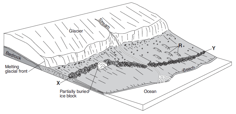
Which feature will most likely form when the partially buried ice block melts?

a)

drumlin

b)

morraine

c)

kettle lake

d)

finger lake

20.
An example of deposition is
a)
a canyon
b)
a delta
c)
Florida
d)
glacier
21.

How are caves formed?

a)

Acidic ground water dissolved the rock

b)

fast moving ground water carries the rock away

c)

the top of the cave collapses

d)

stalagmites fill in the cave

22.

When waves erode softer a layer of softer rock and becomes completely hollowed through

a)

sea cave

b)

sea arch

c)

beach

d)

none of the above

23.

Which of the following is considered a wave EROSION feature

a)

alluvial fan

b)

beach

c)

sea arch

d)

plucking

24.

As the stream erodes the land, what features are likely to form in steep areas?

a)

V-shaped valleys and waterfalls; flood plain, oxbow lakes, and meanders

b)

Alluvial fans ad deltas from sediment

c)

A volcano

25.

Compare and contrast deltas and alluvial fans.

a)

Often contain rapids and waterfalls, the water in a mountain stream moves quickly because it is flowing down.

b)

As water flows down a hillside through fillies, the gullies flow together to form streams.

c)

Deltas and alluvial fans both form when a river slows down or ends, depositing sediment. However, deltas form in water and alluvial fans form on land.

26.

What process forms caves and sinkholes?

a)

Formed by the chemical dissolution of underground rock by the flow of acidic water. If erosion weakens a layer of limestone below the ground, it may collapse and form a sinkhole

b)

Limestone erodes away forming a stream

c)

The oxbow weakens forming a sinkhole

27.

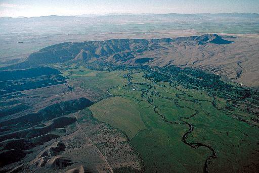
What picture represents a meander?

a)
b)
c)
28.

Which image represents an oxbow?

a)
b)
c)
29.

What is a loess?

a)

thick deposits of windblown large sediment

b)

thick deposits of windblown, fine grained sediment

c)

small deposits of windblown sediments including large rocks

d)

mounds of wind deposited sediment

30.

What type of erosion create the structure in the picture?

a)

wind erosion

b)

water erosion

c)

glacial erosion

d)

mass wasting

31.

What is the definition of deflation?

a)

The process by which wind removes surface materials

b)

Air being let out of something

c)

Small sand grains break apart rocks

d)

The buildup of sand around an obstacle

32.

The sand dune was formed by-

a)

Water

b)

Ice

c)

Wind

d)

Snow

33.
Water that flows over the ground surface rather than soaking into the ground.
a)
rill
b)
rain
c)
runoff
d)
ground water
34.
A tiny groove in soil made by flowing water.
a)
stream
b)
gully
c)
tributary
d)
rill
35.
A channel through which water is continually flowing downhill.
a)
rill
b)
tributary
c)
stream
d)
gully
36.
The stream that flows into a larger stream.
a)
gully
b)
tributary
c)
stream
d)
rill
37.
Wide valley through which a river flows.
a)
delta
b)
V-shaped valley
c)
flood plain
d)
alluvial fan
38.
A meander cut off from a river.
a)
alluvial fan
b)
delta
c)
flood plain
d)
oxbow lake
39.
A landform made of sediment that is deposited where a river flows into an ocean or lake.
a)
delta
b)
alluvial fan
c)
flood plain
d)
oxbow lake
40.
Water that fills the cracks and spaces in underground soil and rock layers.
a)
stream
b)
tributary
c)
groundwater
d)
rain
41.
A calcite deposit that hangs from the roof of a cave.
a)
stalagmite
b)
stalactite
42.
A cone-shaped calcite deposit that builds up from the floor of a cave.
a)
stalagmite
b)
stalactite
43.
A region in which a layer of limestone close to the surface creates deep valleys, caverns and sinkholes.
a)
flood plain
b)
delta
c)
karst topography
d)
V-shaped valley