
Font size
 Worksheets
OST Earth Science Review
Total questions: 36
Worksheet time: 28mins


A scientist finds a snail fossil in a layer of rock in a desert.
Which action would help the scientist determine what the environmental conditions may have been when the snail existed?
looking for more fossils in different layers of rock
counting the number of similar snail fossils in other parts of the world
analyzing the characteristics of other plant and animal fossils found in the same layer of rock
recording information about plants and animals living in the desert today, near where the fossil was found
Secondary waves can pass through __________.
solids
liquids
gases
all
Which of the following statements is TRUE?
The inner core is less dense than the outer core.
The continental crust is denser than the oceanic crust.
The oceanic crust is denser than the continental crust.
The lower mantle is less dense than the asthenosphere.
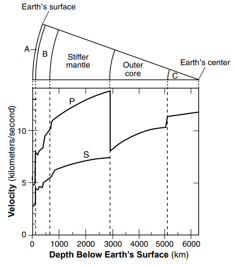
Primary (P) Waves can pass through...
solids only
liquids only
gases only
solids, liquids, and gases
What does the theory of continental drift state?
The continents were once joined in a super-continent and have moved slowly to their current locations
Continents are stationary and do not move
The Earth is broken into lithospheric plates that move due to convection currents
none of the above
In sea-floor spreading, molten material rises from the mantle and erupts _______
along the edges of all the continents.
along mid-ocean ridges.
in deep-ocean trenches.
at the north and south poles.
Magma that turns into rock at the mid ocean ridge, has iron crystals that record...
Earth's magnetism
Earth's gravity
Earth's history
Earth's cosmic rays
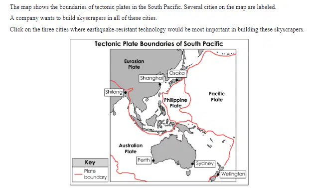
Shanghai
Osaka
Shilong
Wellington
Sydney
Coal is made from decomposed land plants. Coal has been found in the Arctic The coal came from forests that grew in the Arctic in the distant past. Today, The Arctic is too cold to support tree life.
What does the existence of arctic coal tell scientists?
Forests will return to the Arctic in the future.
The Arctic was warmer at some time in the past.
Ancient forest plants could survive very cold temperatures.
Past arctic soils lacked the nutrients needed for plant growth.
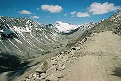
This image shows what kind of landform?
U-shaped valley
river channel
canyon
hanging valley
Scientists are studying a subduction zone in the Pacific Ocean. Which feature are they most likely to study in association with the subduction zone?
mid-ocean rift
rift valley
trench
transform boundary
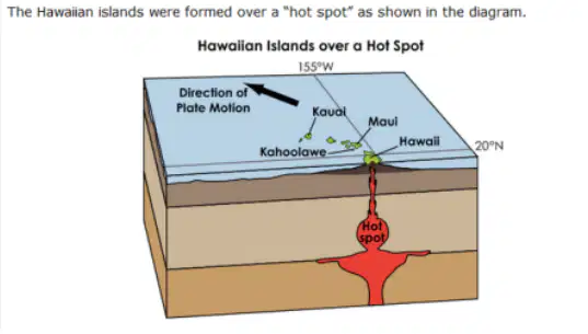
Which island was formed first?
Hawaii
Kahoolawe
Kauai
Maui
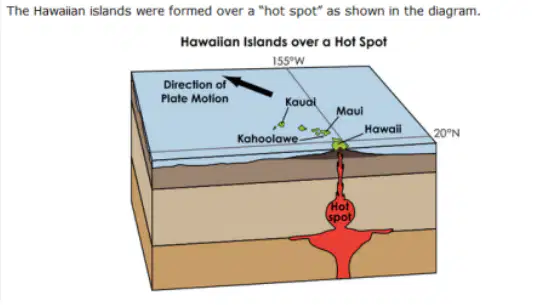
Select the piece of evidence from the diagram that supports your choice for the island that was formed first.
depth of the hot spot
size and shape of the island
presence of an active volcano
direction of plate movement
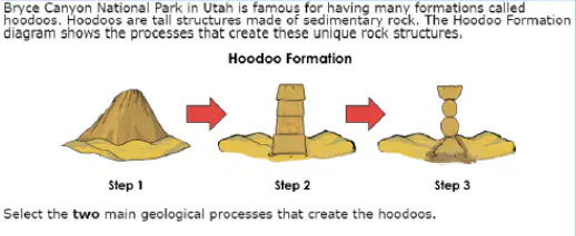
erosion
deposition
weathering
volcanic activity
tectonic movement
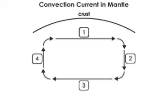
The diagram represents a convection current in Earth's mantle.
Which location shows movement of less-dense material?
1
2
3
4
The diagram represents a convection current in Earth's mantle.
Which location shows heating of cooler material?
1
2
3
4
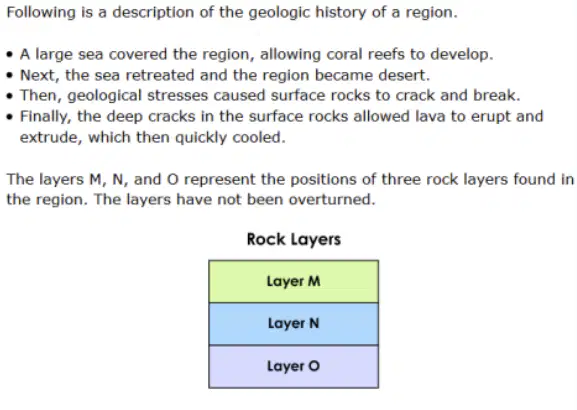
Which layer is composed of sandstone?
Layer N and Layer O
Layer O
Layer N
Layer M
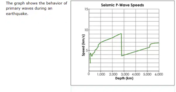
At what depth do the primary waves enter the inner core?
5,200 km
2,800 km
45 km
670 km
The diagrams show two rock units being affected in different ways by tectonic stress. The arrows in each diagram represent the general direction of the stress.
Which diagram shows rocks responding to tectonic stress in a way that could lead to the formation of new crust?


The diagrams show two rock units being affected in different ways by tectonic stress. The arrows in each diagram represent the general direction of the stress.
Which diagram shows rocks responding to tectonic stress in a way that could lead to the formation of mountains?
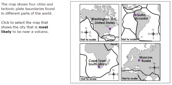
Washington, DC
Quito, Ecuador
Cape Town, South
Moscow, Russia
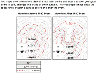
Which conclusion about the resulting changes to Earth's surface is supported by evidence from the maps?
The mountain was weathered into a dome shape
The peak of the mountain increased in elevation.
A large crater formed on the side of the mountain.
Erosion at the top of the mountain widened to its base.
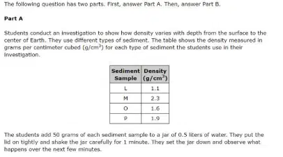
Put the layers in order of how they would settle from bottom to top.
M, P, O, L
P, O, L, M
M, O, L, P
O, L, M, P
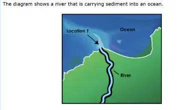
What will happen to most of the sediment being transported by the river water when it first enters the ocean at Location T in the diagram?
Most of the sediment will erode beaches.
Most of the sediment will dissolve in the water.
Most of the sediment will be evenly disturbed throughout the ocean.
Most of the sediment will collect near the mouth of the river near the shore.
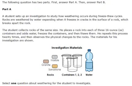
How does temp. affect the degree of weathering?
How do freeze-thaw cycles affect different types of rocks?
How does the amount of water present during a freeze-thaw cycle affect the degree of weathering?
A geologist hiking through the woods in Ohio finds rocks containing fossils in a stream bank. The fossils look similar to animals currently living in the ocean.
Which conclusion should the geologist make based on the discovery of these fossils?
The fossils washed upstream from the ocean.
Animals that live in streams today lived in oceans long ago.
The area of the woods and stream was an ocean long ago.
The area with the streams will become part of the ocean in the future.
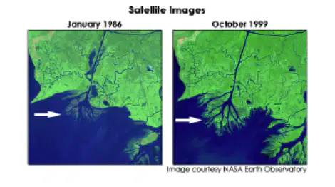
The two satellite images show the changes over time to an area where a river flows into a body of water. The location of a specific change is marked by an arrow.
Select the two constructive geologic processes that caused the change marked by the arrow.
sedimentation
delta formation
tectonic activity
seafloor spreading
Scientists record the types of fossils found in different layers of sedimentary rock in one location. They observe that lower layers have more species than upper layers.
Which piece of evidence would help scientists understand the change in species numbers?
rate of sediment deposition
presence of cross-cutting volcanic intrusions
environmental conditions at the time of deposition
type of parent rock where the sediment weathered
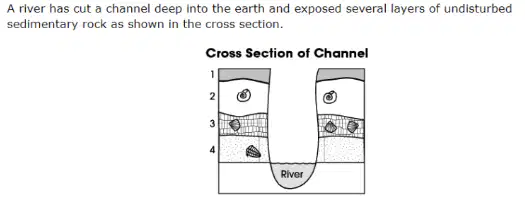
Which layer is oldest?
layer 1 because it is closest to the surface
layer 2 because it has the greatest thickness
layer 3 because it has the most fossils
layer 4 because it is on the bottom

