
 Worksheets
Latitude & Longitude (Geography)
Total questions: 32
Worksheet time: 25mins
Name
Class
Date
1.
What are latitude and longitude lines?
a)
Imaginary lines that divide the Earth
b)
Visible lines that divide the Earth
c)
Long and short lines that divide the Earth
2.

What is the name of this line at 0 degrees latitude?
a)
Prime Meridian
b)
Equator
c)
North Pole
d)
South Pole
3.

What is the name of the line at zero degrees longitude?
a)
Equator
b)
Prime Meridian
c)
North Pole
d)
South Pole
4.

a)
The map show the lines of longitude.
b)
The map shows the lines of latitude.
5.

a)
The map shows lines of longitude.
b)
The map shows lines of latitude.
6.
_______ lines on a globe run from east to west.
a)
North Pole
b)
South Pole
c)
Latitude
d)
Longitude
7.
_______ lines on a globe run from North to South.
a)
North Pole
b)
South Pole
c)
Latitude
d)
Longitude
8.

What is the main line of latitude?
a)
The prime meridian
b)
The Tropic of Cappricorn
c)
The Equator
d)
The prime meridian
9.

Where is the Equator located?
a)
10 degrees
b)
12 degrees
c)
180 degrees
d)
0 degrees
10.

What hemisphere is North America in?
a)
Southern
b)
North West
c)
Western
d)
Eastern
11.

What hemisphere is Australia in?
a)
South East
b)
Northern
c)
Eastern
d)
Western
12.

What hemisphere is Asia in?
a)
North
b)
South
c)
North East
d)
True
13.

What is the approximate location of G?
a)
100oW, 40oN
b)
40oN, 100oW
c)
40oS, 100oW
d)
40oN, 100oE
14.

Which of the following letter is at approximately 60 degrees S, 40 degrees W?
a)
A
b)
D
c)
E
d)
H
15.
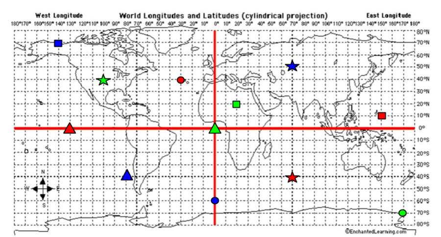
What are the coordinates for the RED Square?
a)
40*S, 70*E
b)
40*N, 30*W
c)
0*, 130*W
d)
10*N, 150*E
16.

What city is located at 32 degrees south and 150 degrees east?
a)
Shanghai
b)
Sydney
c)
Durban
d)
Calcutta
17.
Which city is located at 38 degrees north and 120 degrees west?
a)
San Fransisco
b)
New York
c)
New Orleans
d)
London
18.
Which continent is located completely north of the Equator and west of the Prime Meridian?
a)
Asia
b)
Europe
c)
North America
d)
South America
19.
What are the coordinates for the city of New Orleans?
a)
30 degrees north and 90 degrees west
b)
60 degrees north and 30 degrees east
c)
30 degrees north and 120 degrees east
d)
35 degrees north and 70 degrees west
20.
If you were at 30 degrees south and 60 degrees west, which continent would you be in?
a)
Europe
b)
Africa
c)
South America
d)
Australia
21.
If you were located at 30 degrees south and 90 degress east, what ocean would you be in?
a)
Indian Ocean
b)
Atlantic Ocean
c)
Arctic Ocean
d)
Pacific Ocean
22.
To locate the exact places on Earth, one must look at:
a)
latitude lines only
b)
the intersecting lines of latitude and longitude
c)
longitude lines only
d)
a neighboring area to describe the location
23.
On a globe, or map, the Equator is:
a)
The Horizontal, center line
b)
The Vertical, center line
c)
30 degree line
d)
The North Pole
24.
What ocean would you be in if you were at 30 degrees south and 150 degrees west?
a)
The Atlantic Ocean
b)
The Arctic Ocean
c)
The Pacific Ocean
d)
The Indian Ocean
25.
Lines of Latitude can be measured up to what degree?
a)
150 degrees
b)
180 degrees
c)
90 degrees
d)
100 degrees
26.

Antarctica, Australia, and most of South America are in what hemisphere?
a)
Northern
b)
Southern
c)
Western
d)
Eastern
27.

North and South America are in what hemisphere?
a)
Northern
b)
Southern
c)
Western
d)
Eastern
28.

What cardinal direction goes in the yellow box?
a)
north
b)
south
c)
east
d)
west
29.

What cardinal direction goes in the yellow box?
a)
east
b)
west
c)
south
d)
north
30.

What cardinal direction goes in the yellow box?
a)
northeast
b)
southwest
c)
north
d)
south
31.

What cardinal direction goes in the yellow box?
a)
west
b)
east
c)
southeast
d)
northwest
32.
Which answer shows the tool we
use for cardinal and intermediate
directions?
use for cardinal and intermediate
directions?
a)
line of longitude
b)
compass rose
c)
map
d)
key
100 %

