
 Worksheets
World Geography AAC- Europe Physical Geography
Total questions: 26
Worksheet time: 13mins
Iceland is on both the _ Plate and the _ Plate, causing the country to separate at a rate of 2-3 cm a year. Iceland is divided by the _.
Eurasian Plate, North American Plate, Mid-Atlantic Rift
Antarctic Plate, Pacific Plate, East Pacific Rise
African Plate, Australian Plate, Great Rift Valley
Eurasian Plate, South American Plate, West European Rift
The _ Plate, is the third largest major plate in the world
Eurasian
Pacific
A typically long, narrow inlet with steep sides or cliffs, formed when a glacier retreats.
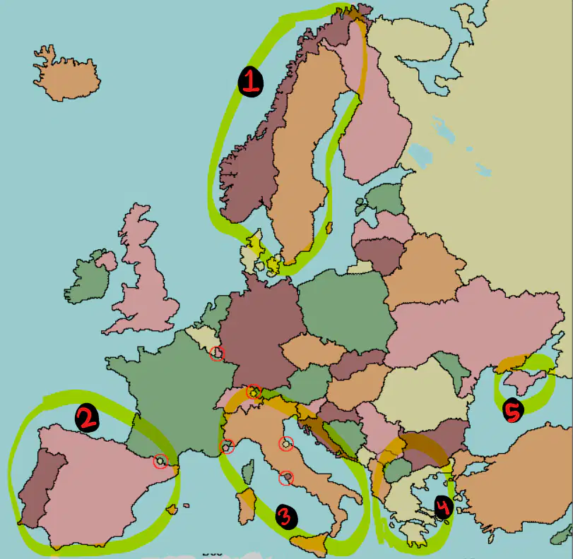
What peninsula is 1?
Crimean Peninsula
Balkan Peninsula
Italian Peninsula
Scandinavian Peninsula
Iberian Peninsula
What peninsula is 2?
Crimean Peninsula
Balkan Peninsula
Italian Peninsula
Scandinavian Peninsula
Iberian Peninsula
What peninsula is 3?
Crimean Peninsula
Balkan Peninsula
Italian Peninsula
Scandinavian Peninsula
Iberian Peninsula
What peninsula is 4?
Crimean Peninsula
Balkan Peninsula
Italian Peninsula
Scandinavian Peninsula
Iberian Peninsula
What peninsula is 5?
Crimean Peninsula
Balkan Peninsula
Italian Peninsula
Scandinavian Peninsula
Iberian Peninsula
a long wall or embankment built to prevent flooding from the sea.
dike
polder
a piece of low-lying land reclaimed from the sea or a river and protected by dikes, especially in the Netherlands.
dike
polder
Dikes and polders are most commonly used in which country?
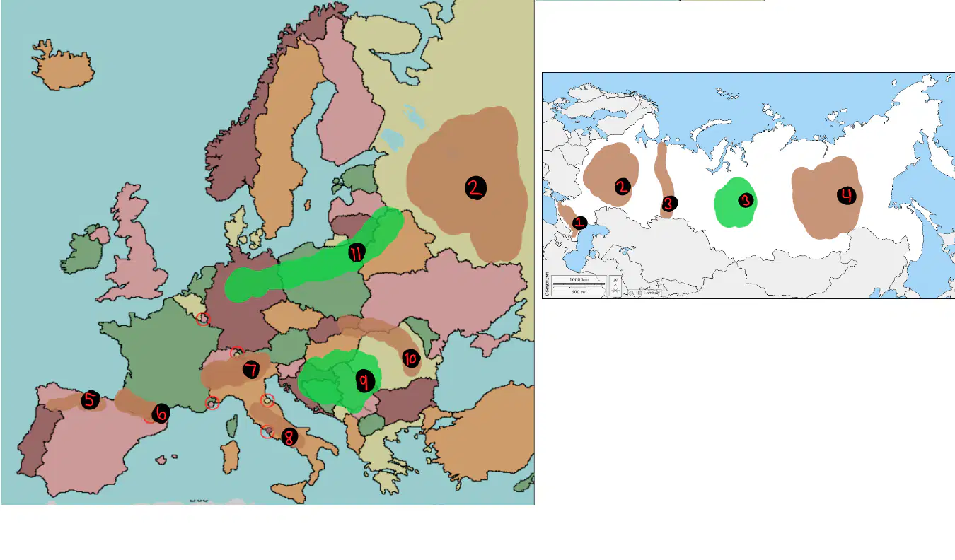
What is 1?
Pyrenees Mountains
Ural Mountains
Cacausus Mountains
Carpathian Mountains
Apennines Mountains
What is 2?
North European Plain
Great Hungarian Plain
Central Russian Upland
Central Siberian Plateau
West Siberian Plain

What is 3?
Pyrenees Mountains
Ural Mountains
Cacausus Mountains
Carpathian Mountains
Apennines Mountains
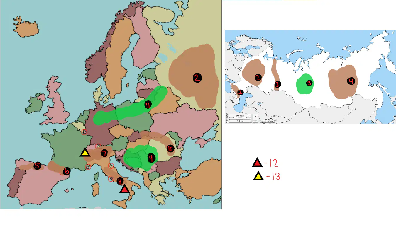
What is 4?
North European Plain
Central Russian Upland
West Siberian Plain
Cental Siberian Plateau
Great Hungarian Plain
What is 5?
The Alps
Ural Mountains
Carpathian Mountains
Cantabrian Mountains
Apennines Mountains
What is 6?
Pyrenees Mountains
Ural Mountains
Cacausus Mountains
Carpathian Mountains
Apennines Mountains
What is 7?
The Alps
Ural Mountains
Carpathian Mountains
Cantabrian Mountains
Apennines Mountains
What is 8?
Pyrenees Mountains
Ural Mountains
Cacausus Mountains
Carpathian Mountains
Apennines Mountains
What is 9?
Great Hungarian Plain
West Siberian Plain
North European Plain
Central Siberian Plateau
Central Russian Upland
What is 10?
Pyrenees Mountains
Ural Mountains
Cacausus Mountains
Carpathian Mountains
Apennines Mountains

What is 11?
Central Siberian Plateau
Great Hungarian Plain
North European Plain
West Siberian Plain
Central Russian Upland
What is 12?
Mt. Krakatoa
Mt. Fuji
Mt. Vesuvuis
Mt. Blanc
Mt. Kilimajaro
What is 13?
Mt. Krakatoa
Mt. Fuji
Mt. Vesuvuis
Mt. Blanc
Mt. Kilimajaro
Oil and natural gas was discovered in the _ sea, though harsh waters present challenges for offshore drilling
Norweigan sea
North Sea
Barents Sea
Baltic sea
Bering sea
Norway uses the _ Sea to generate wind power
Norweigan sea
North Sea
Barents Sea
Baltic sea
Bering sea

