
 Worksheets
Unit 1 Lesson 1 Review
Total questions: 40
Worksheet time: 22mins
What is the name of the imaginary line that divides the Earth into the Northern and Southern Hemispheres?
Equator
Prime Meridian
International Date Line
180° Line
What are the names of the TWO imaginary lines that divide the earth into the eastern and western hemispheres?
Equator and Prime Meridian
Prime Meridian and International Date Line (also called the 180° Line)
Equator and 180° Line
International Date Line and 180° Line
What is another name for the 180° Line?
Equator
Greenwich Meridian
Latitude
International Date Line
Which line of latitude is at 0°?
International Date Line
180° Line
Equator
Prime Meridian



What types of lines are these?
Latitude
Longitude



A line that goes North and South is called _____.
Latitude
Longitude

A line that goes East and West is called _____.
Latitude
Longitude


Which hemisphere is marked with an X?
Northern
Southern
Eastern
Western

Which of the following continents is located entirely in the Southern Hemisphere?
Australia
Africa
Europe
Asia
What is the main purpose of lines of latitude on a map?
To divide the Earth into time zones
To show elevation above sea level
To measure distances east and west of the Prime Meridian
To measure distances north and south of the Equator
Absolute location can be given using ___.
coordinates or a street address
relative location
cardinal directions
intermediate directions
Describing a location in relation to another place is called ___.
absolute location
global grid
relative location
coordinates
What point is located at 90°S?
Equator
North Pole
International Date Line
South Pole
Every 15 degrees of longitude equals ___ hour(s) of time because the Earth rotates 360 degrees in 24 hours, which breaks down to 15 degrees of rotation per hour.
1/2
1
1.5
2
The area between the Tropic of Cancer and the Tropic of Capricorn is called the ___ zone.
polar
temperate
tropical
The areas inside the Arctic Circle and Antarctic Circle are called the ___ zones.
polar
temperate
tropical
The areas in between the tropical zone and the polar circles are called the ___ zones.
polar
temperate
tropical

What part of the map is letter "A"?
compass rose
title
locator map
scale
What part of the map is letter "B"?
compass rose
scale
title
scale
What part of the map is letter "C"?
scale
compass
title
legend
What part of the map is letter "
D"?
title
compass
locator map
legend
What part of the map is letter "E"?
compass rose
scale
locator map
legend
Out of the following options, which is the most accurate representation of Earth?
a Mercator Projection map
a Robinson Projection map
a Homolosine Projection map
a globe
Which is NOT an example of a cardinal direction?
East
Southwest
West
South
Which is NOT an example of an intermediate direction?
SE
NE
WN
SW
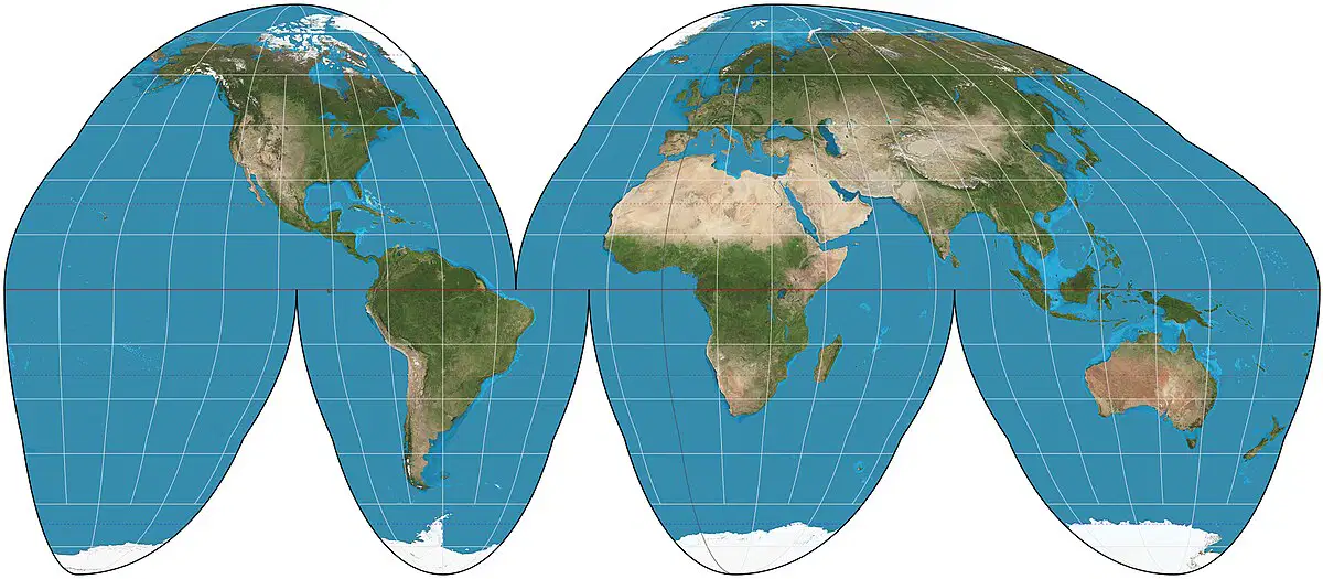
Which map projection is this?
Mercator Projection
Robinson Projection
Homolosine Projection
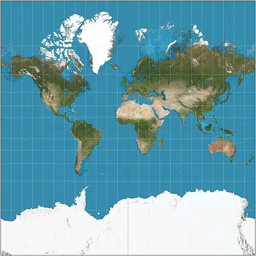
Which map projection is this?
Mercator Projection
Robinson Projection
Homolosine Projection

Which map projection is this?
Mercator Projection
Robinson Projection
Homolosine Projection

If you were leaving the school and wanted to go to the park what direction would you go?
North
East
West
South
If one inch on a map scale = 200 miles and I travel three inches, how many miles have I traveled?
200 miles
400 miles
600 miles
800 miles

