
 Worksheets
Nav - Computations
Total questions: 41
Worksheet time: 21mins
Using you navigation computer calculate: 400 x 16 =
6400
641
6500
635
Using your navigation computer calculate: 156 / 19 =
29.6
2.96
82
8.2
What is the groundspeed of an aircraft that travels 78nm in 53min?
88kts
78kts
68kts
58kts
How long does it take an aircraft with a groundspeed of 95kts to travel 70nm?
32min
1h05min
58min
44min
You measure 23cm on a chart with a chart scale of 1:250,000, what is this in Earth distance (km)?
5.75km
80.6km
806km
57.5km
138L into US gal?
365
36.5
280
28
25 Imp gal of fuel to kg?
10.4
8.2
104
82
75L of AVGAS into kg?
54
69
750
75
190nm into sm?
202
208
218
220
Your aircrafts fuel consumption rate is 39L/hr, how many L will be consumed in 1h38mins?
60
64
70
74
What is the aircrafts fuel consumption rate if 59L are missing after 85mins?
41.6
52.8
59.7
63.2
1390m to feet?
7076
4560
3280
8880
65sm to km?
10.5
9.55
1950
105
160 US gal of fuel to kg?
43.6
436
89.3
893
What wind has affected your aircraft:
120kts GS
300°T track
Variation 20°E
105kts TAS
Drift 14°R
352/19
188/25
176/33
060/5
What wind has affected your aircraft:
90kts GS
035°M track
Variation 13°W
115kts TAS
Drift 8°L
067ºM/30
130ºM/15
078ºT/9
334ºT/18
Calculate the heading and GS:
140°T/19kts
180°M TRK
Variation 10°W
145kts TAS
129kts, 176ºM
129kts, 184ºM
116kts, 176ºM
116kts, 184ºM
Calculate the heading and GS:
279°T/19kts
005°T TRK
Variation 10°W
95kts TAS
290ºT, 108kts
016ºT, 108kts
268ºT, 92kts
354ºT, 92kts
Determine the headwind and crosswind:
Possible runways - 060, 240
Wind - 360/16kts
12kts, 6kts
6kts, 12kts
8kts, 13kts
15kts, 8kts
Determine the headwind and crosswind:
Possible runways - 130, 310
Wind - 090/35kts
18kts, 20kts
20kts, 18kts
22kts, 27kts
27kts, 22kts
Convert 22 degrees Celsius to degrees Fahrenheit
72ºF
70ºF
75ºF
74ºF
You are going to descend from 8500' to 1500'. Based on your groundspeed, this will take you 8 minutes. What should your rate of descent be?
875 ft/min
87.5 ft/min
885 ft/min
88.5 ft/min
If you set heading overhead Queenstown at 2000ft AMSL and will climb to 8000ft AMSL, what altitude should you take the wind from?
6000ft
5000ft
4000ft
7000ft
CAS: 150kt
Pressure altitude: 5500ft
OAT: -25°C
What is TAS?
156kts
160kts
146kts
140kts

Your flight plan has you descending from 9000ft down to 3000ft to arrive overhead Glentanner aerodrome. What temperature and wind will you use?
29033 MS02
27033 MS05
29033 MS05
31020 MS02
Reserve fuel is taken at what consumption rate?
Cruise consumption
Holding consumption
Circuit and landing consumption
Taxi consumption
The specific gravity of AVGAS is?
0.72
0.80
0.76
0.78
If you have to climb from 3000ft to 6000ft and your aircraft climbs at a dismal 250ft per minute, how many minutes will it take to climb?
12 min
8 min
3 min
9 min
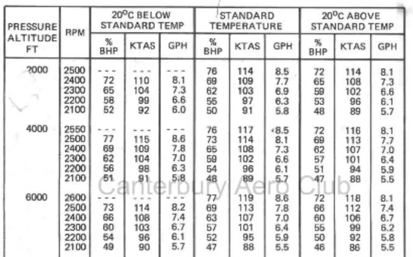
You're at a pressure altitude of 5000ft with the RPM set for cruise at 2400rpm. The temperature is 20° above standard. What is your fuel consumption in GPH?
6.85 GPH
6.7 GPH
7 GPH
7.6 GPH
Your fuel consumption rate is 33 liters an hour and you want to know how much fuel you'll burn on a specific leg. The leg is 112nm and you have a ground speed of 105kt.
35.2L
38.2L
30.2L
40.2L
You are maintaining a track of 100°M by holding a heading of 110°M. The weather up ahead doesn't look very good and you decide to turn around. What heading should you set on the way back?
280ºM
290ºM
270ºM
105ºM
Calculate PNR time and distance for a daytime flight between NZUK and NZNS given the following:
Fuel loaded: 266L
Fuel burn: 38L
TAS: 310kt
Winds NZUK to PNR: +35kt
Winds PNR to NZNS -20kt
2.9 hours 1000nm
2.5 hours 863nm
3.2 hours 1104nm
4.6 hours 1587nm
Calculate ETP time and distance for a daytime flight between A and B given the following:
Total distance: 550nm
TAS: 240kt
Winds A to ETP: +15kt
Winds ETP to B -15kt
275nm 69min
255nm 50min
295nm 77min
315nm 85min
You are flying from A to B. You find that your position is 60 nm outbound from A and 7 nm left of the required track. What is your track error angle?
7ºR
7ºL
14ºR
14ºL
Calculate PNR given the following information for a daytime flight from NZCH to NZHM (Hanmer).
Fuel load: 120L
Fuel burn: 30L an hour
TAS: 120kt
Wind from NZCH to PNR: -20kt
Wind from PNR to NZHM: +10kt
2hrs
1.5hrs
2.5hrs
3hrs
NZCH to NZAS (Ashburton)
Total distance: 82nm
TAS: 115kt
Wind from NZCH to ETP: +10kt
Wind from ETP to NZAS: +15kt
What is ETP distance from NZAS?
36km
46nm
36nm
46km
You plan a day trip from NZCH to NZWS (Westport) in your Texan. It has a TAS of 315kt and a fuel consumption of 30GHP. You load on 110 gallons and check your flight plan which states a total ditance of 132nm and a tailwind of 18kt from NZWS to NZCH. What is PNR and ETP distance?
PNR = 700nm ETP = 500nm
PNR = 50nm ETP = 70nm
PNR = 70nm ETP = 50nm
PNR = 500nm ETP = 70nm
You plan a night-time flight from NZCH to NZHK (Hokitika) which is 102nm total distance. Your TAS is 105kt and you have a wind of +15kt. If you load up 100L of fuel and your fuel burn is 36L an hour, what is PNR distance and ETP time?
PNR = 0.84 ETP = 44nm
PNR = 100nm ETP = 22 minutes
PNR = 50 minutes ETP = 44nm
PNR = 60nm ETP = 25 minutes
55 x 123
6760
676
7150
686
7500 / 280
GIVE ANSWER IN 1 DECIMAL PLACE
(a)
What is the VFR legal fuel required for a day flight?
30min
10% of the flight time
45min
Enough to get to the alternate aerodrome

