wayground logo

Free Printable Worksheets

Font size

S
M
L
XL
Worksheets

Fall 2025 Final Exam Study Guide

Total questions: 74

Worksheet time: 45mins
Name
Class
Date
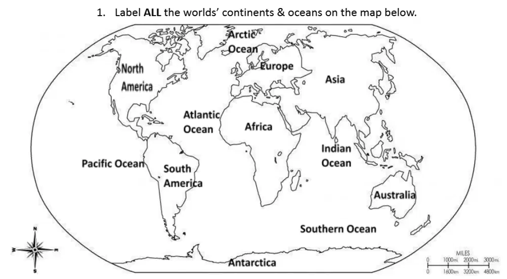
1.

Identify ALL the world's continents & oceans on the map below.

a)
Continents: North America, South America, Europe, Africa, Asia, Australia, Antarctica; Oceans: Pacific Ocean, Atlantic Ocean, Indian Ocean, Arctic Ocean, Southern Ocean.
b)
South Antarctica
c)

Central Ocean, Genevan Ocean, Atlantic Ocean, Pacific, European Ocean.

d)

North Asia, Africa, Canada, Australia, Ocean of Mexico, Oceans of Fun.
2.

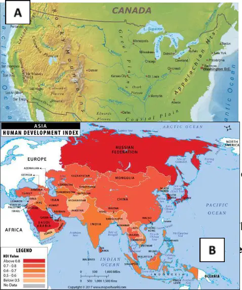
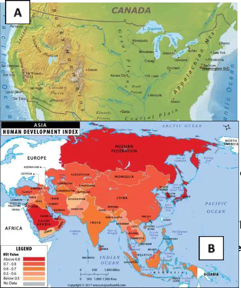
What type of map is map A? Provide one reason why you know this.

a)

Physical map, it shows mountain, plain.

b)

Thematic map, it shows HDI

c)
Topographic map
d)

Political map, it shows land use

3.

What type of map is map B? Provide one reason why you know this.

a)

Map B is a thematic map because the theme is HDI.

b)
The map B is a road map.
c)

The map B is a political map because it show countries.

d)

The map B is a physical map it show the Ural Mountains.
4.

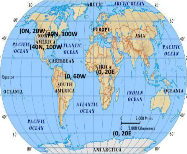
How do geographers define Absolute Location?

a)
The location of a place in relation to another place
b)
A general description of an area
c)
Absolute location is defined by specific coordinates (latitude and longitude) that pinpoint an exact location.
d)
Relative location based on nearby landmarks
5.

Define Relative Location in terms of Geography.

a)
Relative location is the exact coordinates of a place.
b)
Relative location is the position of a place in relation to other places.
c)
Relative location refers to the climate of a region.
d)
Relative location is the historical significance of a place.
6.

Define Climate:

a)
Long term (ex. Humid, Dry)
b)

Climate is the region of the world you live in.

c)

Climate is short term conditions such and sunny, hot.

d)

Climate is country close to the mountains.
7.

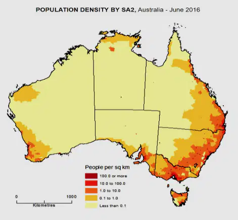
Describe the population distribution of Australia:

a)
Near the Eastern Coast.
b)

Central

c)

Australia is too dangerous for people to live in.

d)

West

8.

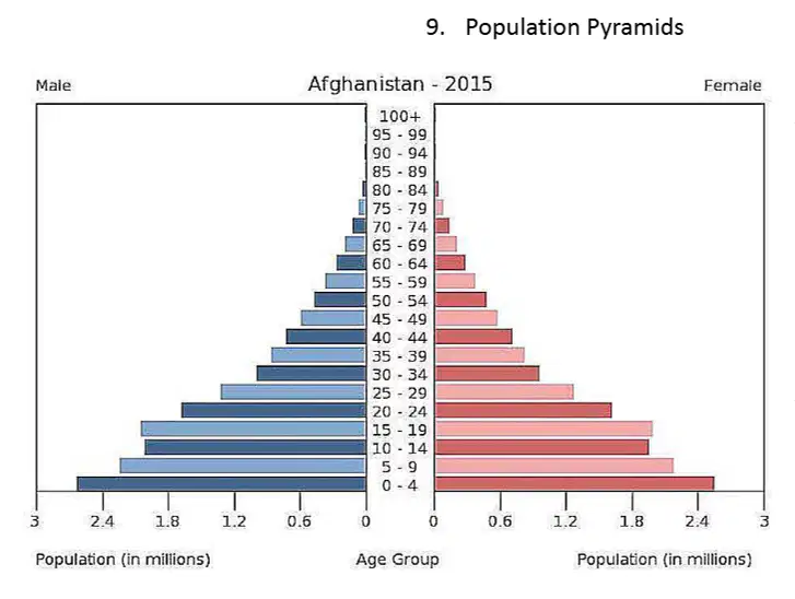
What shape is this pyramid?

a)
Pyramid
b)

Ice

c)

Cream

d)

Cone

9.

Would Afghanistan be considered developed or developing? (circle one)

a)

Developed

b)

Developing

10.

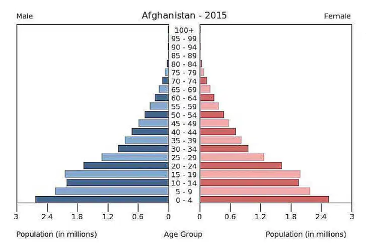
What shape is this pyramid?

a)
Cone.
b)

Square

c)

Pyramid

d)

House

11.

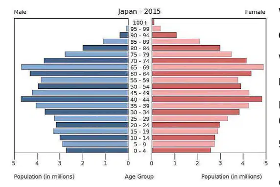
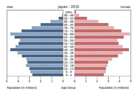
Use the Japan graph on page 6 of study guide, Questions 9. How many females are there, ages 65-69?

a)

5 Million

b)

1 Million

c)

10 Millions

d)

6 Million

12.

Would Japan be considered developed or developing? (circle one)

a)

Developed

b)

Developing

13.

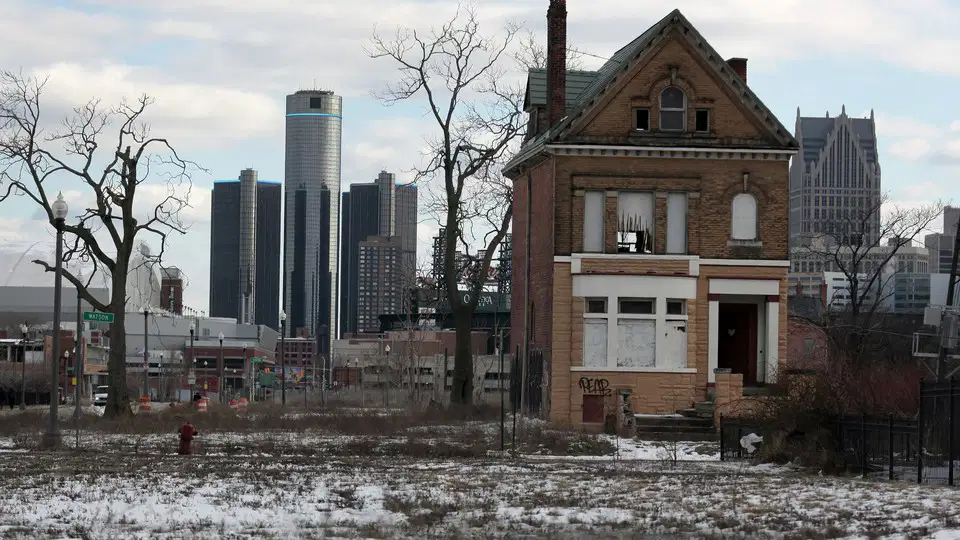
Explain why The Northeast and The Midwest are nicknamed the “Rustbelt”.

a)
The nickname is due to the abundance of natural resources in the Northeast and Midwest.
b)
The Northeast and The Midwest are nicknamed the 'Rustbelt' because of the decline of manufacturing industries, leading to economic decline and abandoned factories.
c)
The Rustbelt refers to the thriving tech industry in these regions.
d)
The Northeast and The Midwest are known for their agricultural production.
14.

What provinces exist inside Canada’s “Core” region?

a)
Quebec, Ontario
b)

Washington, Oregon

c)

Quebec, Michigan

d)

Ontario, Quana

15.

What physical feature exists in the U.S. Midwest & Canada’s Prairie that earn them the nickname “Breadbasket”?

a)
Great Plains
b)

Rocky Mountains

c)

Appalachian Mountains

d)

Great Rift Valley

16.

What region of Canada has the most dense population?

a)
The Core, South Canada
b)

The Northern Inuit part

c)

The Ice Caps

d)

Alaska

17.

Which of the following define Urbanization?

a)
The process of building new rural communities.
b)
The decline of cities due to population loss.
c)
The process of population shift from rural to urban areas, leading to city growth.
d)
The increase in agricultural production in rural areas.
18.

Which of the following statements define Urban Sprawl?

a)
Urban sprawl is the uncontrolled expansion of urban areas into rural land.
b)
Urban sprawl is the preservation of rural land from urban development.
c)
Urban sprawl is the development of high-rise buildings in urban areas.
d)
Urban sprawl refers to the increase in population density in city centers.
19.

What is a megalopolis?

a)
A megalopolis is a small rural community.
b)

A megalopolis is a large urban area formed by the merging of multiple cities that touch each other.

c)
A megalopolis is a type of ancient monument.
d)
A megalopolis is a natural landscape with no urban development.
20.

What do the U.S. megalopolises have in common?

a)
They are primarily rural areas with low population density.
b)

They are large, interconnected urban areas that are by the coast.

c)
They are small towns with limited economic activity.
d)
They are isolated cities with no transportation links.
21.

Would the U.S. be considered developed or developing? (circle one)

a)

Developed

b)

Developing

22.

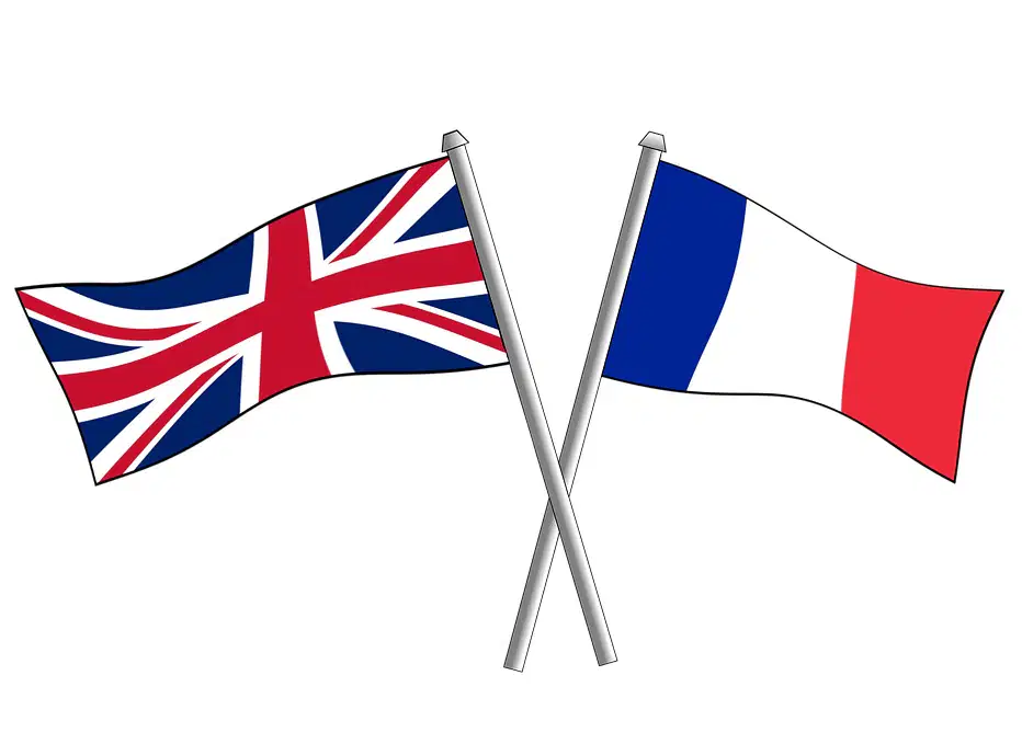
What two languages have led Quebec to declare itself a bilingual province?

a)

English.

b)

French.

c)

Arabic

d)

Inuit

23.

What explains why Quebec became bilingual?

a)
Quebec became bilingual due to its geographical location.
b)

Quebec became bilingual due to historical conquests by France and England.

c)
Quebec became bilingual because of its natural resources.
d)
Quebec became bilingual as a result of technological advancements.
24.

What were the 3 Gs that encouraged Europeans to colonize the Americas?

a)

God

b)

Gold

c)

Glory

d)

Green Bay

25.

What types of governments did the Spanish & Portuguese colonizers bring to Latin America?

a)
Democratic governments elected by the local population.
b)

Absolute Monarchy governments led by viceroys or governors.

c)
Monarchies with local kings ruling independently.
d)
Anarchist systems with no formal government structure.
26.

What is an Absolute Monarchy?

a)
A form of government where the people elect their leaders.
b)
A government led by a council of nobles without a monarch.
c)
A government system where a monarch has absolute power over the state.
d)
A system where the monarch shares power with elected officials.
27.

What is the purpose of free trade zones like CAFTA-DR & NAFTA? Explain how agreements like this lead to interdependence.

a)
To isolate member countries from global markets.
b)
To promote competition among member countries without cooperation.
c)
The purpose of free trade zones like CAFTA-DR and NAFTA is to reduce trade barriers and promote economic cooperation, leading to interdependence among member countries.
d)
To increase tariffs on imports and exports.
28.

List out push and pull factors for emigrants leaving Latin America.

a)

Pull Factors: Jobs, Food, Safety.

Push Factors: No Jobs, Famine, Disease

b)

Push Factors: Too much money.

Pull Factors: Love of war

c)

Push Factors: Too much Freedom.

Pull Factors: Dictatorships.

d)

People don't want to leave Latin America because of the nice weather.

29.

Explain how polders, dikes, and canals are an example of a modification.

a)
Polders, dikes, and canals are primarily used for agricultural purposes only.
b)

Polders, dikes, and canals are changes made to the landscape to manage water and prevent flooding.

c)
Polders, dikes, and canals are examples of urban development unrelated to water management.
d)
Polders, dikes, and canals are natural formations that occur without human intervention.
30.

What are the benefits of the EU figuratively “erasing” borders in Europe?

a)
Increased military conflict
b)
Decreased cultural diversity
c)
Higher border security costs
d)
Increased trade, economic growth, cultural exchange, enhanced cooperation, and peace.
31.

What does the future hold for the UK within the European Union after the referendum?

a)
The UK will strengthen its ties with the EU and remain a member.
b)
The UK will become a full member of the Schengen Area.
c)
The UK will join the Eurozone and adopt the Euro as its currency.
d)

The UK will leave the EU and will seek to establish new trade and political relationships.

32.

What did Scotland say they will do if England leaves?

a)
Scotland will build a wall along the border.
b)

Scotland would leave England.

c)
Scotland will increase trade tariffs with England.
d)
Scotland will join the European Union immediately.
33.

Explain why Catalans are currently considered a stateless nation:

a)
Catalans have their own recognized state and government.
b)
Catalans are part of a larger nation and do not seek independence.
c)

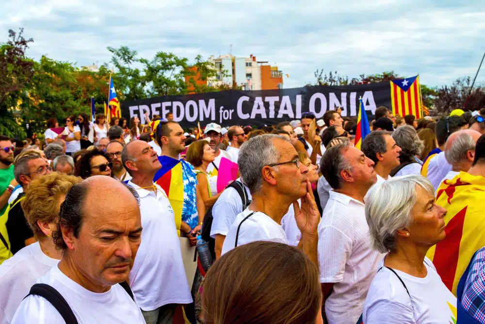
Catalans are considered a stateless nation due to their distinct identity and aspirations for independence.

d)
Catalonia is a fully independent country with no aspirations for autonomy.
34.

What is a climograph?

a)
A climograph is a chart that displays the wind speed and direction for a region.
b)
A climograph is a type of weather balloon used for measuring atmospheric pressure.
c)
A climograph is a diagram that illustrates the phases of the moon over a year.
d)
A climograph is a graph that shows average temperature and precipitation for a location over time.
35.

Which of the following explains Karl Marx's theory of Communism?

a)
Communism is a classless society with collective ownership of production.
b)
Communism encourages social hierarchies and class divisions.
c)
Communism is based on a capitalist economy.
d)
Communism promotes individual ownership of property.
36.

What happened to the environment under the USSR?
a)
The environment suffered severe degradation due to industrialization and neglect of ecological concerns.
b)
The environment thrived due to sustainable practices and conservation efforts.
c)
The USSR implemented strict environmental regulations that improved ecological health.
d)
Industrialization had no impact on the environment during the USSR era.
37.

Describe the characteristics of Lake Baikal.


a)

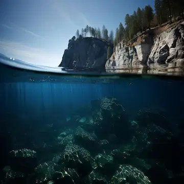
Lake Baikal is the deepest and oldest freshwater lake, containing 20% of the world's unfrozen freshwater. Experienced contamination

b)
Lake Baikal is known for its tropical climate and sandy beaches.
c)
Lake Baikal is the largest lake in the world by surface area.
d)
Lake Baikal is a saltwater lake located in the Arctic.
38.

What occurred at Chernobyl in 1986?

a)
A major earthquake struck the region.
b)
A nuclear disaster occurred at the Chernobyl power plant.
c)
A new power plant was inaugurated nearby.
d)
A significant oil spill occurred in the area.
39.

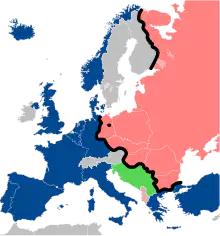
What was the "Iron Curtain"?


a)
The 'Iron Curtain' was a metaphorical division between Eastern and Western Europe during the Cold War.
b)
A type of iron ore used in construction.
c)
A military alliance formed during World War II.
d)
A physical barrier built to separate countries in Europe.
40.

After the collapse of the USSR, what happened to satellite nations?

a)
Satellite nations were absorbed into Russia.
b)
Satellite nations remained under Soviet control.
c)
Satellite nations formed a new alliance with China.
d)
Satellite nations became independent countries.
41.

What was the political system and economic system of the Soviet Union?

a)
Federal republic with a capitalist economy.
b)
Multi-party democracy with a market economy.
c)
Single-party state with a mixed economy.
d)

Single-party state/dictatorship with a communist economic system.

42.

What landform supports the majority of the food production in Eastern Europe and Russia?
a)
Chernozem (black soil) plains
b)
Desert regions
c)
Mountain ranges
d)
Coastal areas
43.

Who was Czar Peter the Great?

a)
Czar Peter the Great was a military leader in ancient Greece.
b)

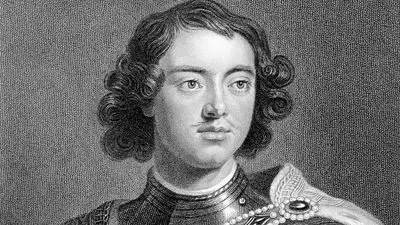
Czar Peter the Great was the ruler of Russia who modernized the country and ruled from 1682 to 1725.
c)
Czar Peter the Great was the King of France during the 17th century.
d)
Czar Peter the Great was a famous painter from Italy.
44.

What reasons has Catalonia given for wanting to separate from Spain?

a)
Catalonia wants to separate to avoid cultural assimilation with Spain.
b)
Catalonia aims to become a monarchy separate from Spain.
c)
Catalonia wants to separate from Spain due to national identity, cultural differences, economic grievances, and the belief in better governance as an independent state.
d)
Catalonia seeks to join France for better economic opportunities.
45.

Define Weather in terms of Geography.

a)
Weather is the long-term average of atmospheric conditions.
b)
Weather refers to the geological features of a region.
c)

Weather is how you feel.

d)

Weather is the short-term, characterized by conditions such as temperature, humidity, and precipitation.

46.

My house is next to highway 90.

a)

Relative

Location

b)

Absolute

Location

47.
As you go to the top of a mountain, what happens to temperature?
a)
Nothing
b)
It increases
c)
It decreases
d)
It goes up and down
48.

the pattern of weather over a long period of time

a)

Climate

b)

Economic Activity

c)

Landform

d)

Physical Feature

49.

What is the center line of latitude?

a)

Equator

b)

Prime meridian

c)

Longitude

d)

latitude

50.

This is a map of South America. Where is the Pacific Ocean located on the map? Select TWO correct answers.

a)

Ecuador

b)

Chile

c)

Colombia

d)

Venezuela

e)

Guyana

51.

Which continent would be considered the largest and most diverse on Earth? Select the correct answer.

a)

Europe

b)

Africa

c)

Asia

d)

North America

e)

South America

52.

The oceans of the world are

a)

atlantic,indian,artic,southern,rio grande

b)

gulf of mexico,rio grande, nile river, artic

c)

atlantic,indian,artic,pacific,southern

d)

red river, artic, atlantic, indian,

53.

The Ural Mountains separates which two continents?

a)

Australia from Africa

b)

North America from Asia

c)

Europe from Russia

d)

Europe from Asia

54.

In 1986, ________________, the nuclear power plant in the Ukraine that suffered two large explosions which released massive amounts of radioactive materials.

a)

Chernobyl

b)

Hiroshima

c)

Nagasaki

d)

None of the above

55.

Which body of water is located at "B"

a)

South China Sea

b)

Atlantic Ocean

c)

Mediterranean Sea

d)

Baltic Sea

56.

What type of map is this?

a)

Political

b)

Physical

c)

Thematic

d)

Mental

57.
a)
The map show the lines of longitude.
b)
The map shows the lines of latitude.
58.
a)
The map shows lines of longitude.
b)
The map shows lines of latitude.
59.

#3 is what country?

a)

United States

b)

Mexico

c)

Canada

60.

What country is #1?

a)

Peru

b)

Ecuador

c)

Argentina

d)

Chile

61.

What physical feature is #2?

a)

Amazon Mountains

b)

Andes Mountains

c)

Patagonia Mountains

d)

Panama Mountains

62.

What physical feature is #3?

a)

Amazon Canal

b)

Andes Canal

c)

Patagonia Canal

d)

Panama Canal

63.

What term is used to describe the reasons people leave their homes and migrate (ex. civil war)?

a)

Push Factors

b)

Pull Factors

c)

Refuge

d)

Evacuate

64.

What term is used to describe the reasons people leave their homes and migrate to a new location (ex. job opportunity)?

a)

Push Factors

b)

Pull Factors

c)

Refuge

d)

Evacuate

65.

What term is used to describe a person who is forced to leave home because of dire threats to well-being for a long period of time or forever?

a)

Migrant

b)

Immigrant

c)

Refugee

d)

Evacuee

66.

Trade pacts such as _________, have made trade much easier, and created and taken jobs from the countries associated (United States, Mexico, and Canada).

a)

NAFTA

b)

OPEC

c)

EU

d)

UN

67.

Which feature is located at the letter J on the map?

a)

Pyrenees Mountains

b)

Iberian Peninsula

c)

English Channel

d)

European Plain

68.

Which country is located at the letter A on the map?

a)

France

b)

Italy

c)

Ukraine

d)

Germany

69.

Which country is highlighted on the map?

a)

Albania

b)

Serbia

c)

Greece

d)

Montenegro

70.

What number represents the Andes Mountains?

a)

1

b)

2

c)

3

71.

What number represents the Amazon River Basin?

a)

1

b)

2

c)

3

72.
What Central American country is circled on the map?
a)
Cuba
b)
Haiti
c)
Panama
d)
Bolivia
73.

What country is marked in orange?

a)

Mexico

b)

Guatemala

c)

Costa Rica

d)

Chile

74.

What country is marked in red?

a)

Cuba

b)

Bolivia

c)

Peru

d)

Ecuador