
 Worksheets
Mapping Earth's Surface Unit Quiz
Total questions: 40
Worksheet time: 3hrs 41mins
Name
Class
Date
1.
What is topography?
a)
The study of maps
b)
The shape of the land including elevation, relief, and landforms
c)
The process of creating globes
d)
The measurement of ocean depths
2.
Which of the following is NOT one of the three main types of landforms?
a)
Plains
b)
Mountains
c)
Plateaus
d)
Valleys
3.
What is the difference between a mountain range and a mountain system?
a)
A mountain range is larger than a mountain system
b)
A mountain system includes multiple mountain ranges
c)
A mountain range is only found near oceans
d)
There is no difference
4.
What is a landform region?
a)
A small area with many different types of landforms
b)
A large area where the topography is mainly one type of landform
c)
A region without any landforms
d)
An area only found in coastal regions
5.
What is the main difference between a map and a globe?
a)
A map is three-dimensional while a globe is flat
b)
A map represents only part of Earth's surface while a globe represents the entire surface
c)
A globe uses symbols while a map doesn't
d)
A map is always more accurate than a globe
6.
What does 'scale' refer to in mapmaking?
a)
The size of the map
b)
The colors used on the map
c)
The relation of distance on a map to actual distance on Earth
d)
The number of symbols used
7.
What is the equator?
a)
An imaginary line connecting the North and South Poles
b)
The longest line of latitude
c)
An imaginary line dividing Earth into Eastern and Western hemispheres
d)
An imaginary line dividing Earth into Northern and Southern hemispheres
8.
What is the Prime Meridian?
a)
The longest line of longitude
b)
An imaginary line connecting the North and South Poles
c)
An imaginary line dividing Earth into Eastern and Western hemispheres
d)
The equator
9.
What do lines of latitude measure?
a)
Distance east or west of the Prime Meridian
b)
Distance north or south of the equator
c)
Elevation above sea level
d)
The curvature of the Earth
10.
What is a degree in the context of Earth's geography?
a)
A measure of temperature
b)
1/360 of a way around a circle
c)
A unit of distance equal to 1 km
d)
The angle between latitude and longitude lines
11.
Which map projection shows straight lines for both latitude and longitude but distorts land near the poles?
a)
Mercator projection
b)
Equal-area projection
c)
Conic projection
d)
Cylindrical projection
12.
What is the main characteristic of an Equal-area projection?
a)
It maintains accurate shapes of all land masses
b)
It distorts shapes around the edges of the map
c)
It shows straight lines for both latitude and longitude
d)
It is only useful for small areas
13.
In a Conic projection, how are the longitude and latitude lines represented?
a)
Both are curved
b)
Both are straight
c)
Longitude is straight, latitude is curved
d)
Latitude is straight, longitude is curved
14.
What is surveying in the context of mapmaking?
a)
The process of coloring maps
b)
The process of determining distances and elevations using instruments and geometry
c)
The process of naming geographical features
d)
The process of printing maps
15.
How have computers revolutionized mapmaking?
a)
They have made paper maps obsolete
b)
They allow for automatic generation of maps from various data sources
c)
They have made surveying unnecessary
d)
They have eliminated the need for map projections
16.
What does GPS stand for in the context of mapping?
a)
Global Positioning System
b)
Geographical Projection Software
c)
Ground Plane Survey
d)
Grid Point System
17.
What are satellite images composed of?
a)
Vector graphics
b)
Contour lines
c)
Pixels
d)
Topographic symbols
18.
What is a topographic map?
a)
A map showing only political boundaries
b)
A map showing surface features using symbols, as if viewed from above
c)
A map showing only elevation data
d)
A map showing only water features
19.
What do contour lines on a topographic map represent?
a)
Political boundaries
b)
Roads and highways
c)
Points of equal elevation
d)
River systems
20.
What is a contour interval?
a)
The distance between two contour lines on a map
b)
The change in elevation from one contour line to another
c)
The total elevation of a landform
d)
The space between two mountains
21.
What is the purpose of a map legend?
a)
To explain the symbols and colors used on the map
b)
To display the latitude and longitude lines
c)
To show the direction of north
d)
To indicate the scale of the map
22.
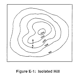
What is the contour interval on this map?
a)
100
b)
10
c)
15
d)
20
23.
It is steep on a topographic map where __________.
a)
lines are closest together
b)
a river flows into a lake
c)
contours bend
d)
contours are far apart
24.

Determine the contour interval:
a)
5 m
b)
10 m
c)
15 m
d)
20 m
25.
When you move from one contour line to another, the elevation
a)
stays the same
b)
goes up or down
c)
disappears
d)
is below sea level
26.

If sea level always equals (0), and the contour interval is 10 feet how tall is this mountain?
a)
30 ft
b)
40 ft
c)
50 ft
d)
60 ft
27.

Match the topographic map to its profile.
a)
b)
c)
d)
28.

Match the topographic map to its profile picture.
a)
b)
c)
d)
29.
Line drawn on a map that connects all points with the same elevation
a)
contour line
b)
contour interval
c)
sea level
30.
What do contour lines that are farther apart represent?
a)
waterfall
b)
steep area
c)
gentle slope
d)
river
31.

What is the contour interval?
a)
1 ft
b)
5 ft
c)
10 ft
d)
60 ft
32.

Which side of this island is the steepest?
a)
South
b)
North
c)
East
d)
West
33.

How many mountain peaks are represented?
a)
one
b)
two
c)
three
d)
four
34.
On a topographic map of a mountain, you walk a longer distance to get to the top when the contour lines are
a)
spread out
b)
close together
c)
going down
d)
going up
35.
The height above sea level is called
a)
topographic
b)
contour
c)
elevation
d)
depth
36.

In which direction is Mill River flowing?
a)
Southeast
b)
Southwest
c)
Northeast
d)
Northwest
37.

What is the highest elevation on this map?
a)
Over 320 meters
b)
Over 450 meters
c)
Over 220 meters
d)
Over 380 meters
38.

What is the elevation of the peak of the small island on the left side?
a)
About 20 meters
b)
About 40 meters
c)
About 60 meters
d)
About 200 meters
39.

What feature is formed at B?
a)
river
b)
rift valley
c)
sink hole
d)
mountain
40.

If we were in a plane, Path B --> C is about the same distance as path E --> N. But, which path is the easier walk?
a)
B --> C is the easier walk
b)
E --> N is the easier walk
c)
B --> C and E --> N are the same walking distance
100 %

