
 Worksheets
QUARTER 4 REVIEW
Total questions: 63
Worksheet time: 32mins
Name
Class
Date
1.
Fault plane is inclined at an angle of less than 45 degrees from the horizontal experiences vertical motion,
a)
Normal Fault
b)
Reverse Fault
c)
Strike-slip Fault
d)
2.
Fault plane that hanging wall moving downward relative to the footwall.
a)
Normal Fault
b)
Reverse Fault
c)
Strike-slip Fault
d)
3.
Fault plane is inclined at an angle greater than 45 degrees from the horizontal experiences vertical motion,
a)
Normal Fault
b)
Reverse Fault
c)
Strike-slip Fault
d)
4.
Fault plane hanging wall moving upward relative to the footwall.
a)
Normal Fault
b)
Reverse Fault
c)
Strike-slip Fault
d)
5.
What fault plane is nearly vertical with minimal inclination from the horizontal
a)
Normal Fault
b)
Reverse Fault
c)
Strike-slip Fault
d)
6.
Fault that experiences predominantly lateral motion along the fault plane.
a)
Normal Fault
b)
Reverse Fault
c)
Strike-slip Fault
d)
7.
Which fault is also known as a thrust fault?
a)
Normal Fault
b)
Reverse Fault
c)
Strike-slip Fault
d)
8.
Which fault will result in the formation of a valley?
a)
Normal Fault
b)
Reverse Fault
c)
Strike-slip Fault
d)
9.
Which type of fault generates earthquake by sliding past each other?
a)
Normal Fault
b)
Reverse Fault
c)
Strike-slip Fault
d)
10.
Which fault will likely form a mountain?
a)
Normal Fault
b)
Reverse Fault
c)
Strike-slip Fault
d)
11.
What is generated when stress builds up along a fault?
a)
A tsunami
b)
A volcanic eruption
c)
An earthquake
d)
A landslide
12.
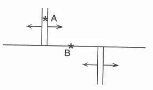
What type of earthquake would likely occur in point A?
a)
Shallow-focus earthquakes caused by strike-slip faulting
b)
Shallow-focus earthquakes caused by normal faulting
c)
Shallow-focus earthquakes caused by thrust faulting
d)
Deep-focus earthquakes caused by thrust faulting
13.
If a city is built on top of a strike-slip fault, which of the following would be the MOST noticeable effect during an earthquake
a)
The land will move sideways, shifting roads and buildings.
b)
Ground shaking will cause parts of the city to sink.
c)
Mountains will suddenly form due to compression.
d)
The land will split open, forming a deep canyon.
14.
A geologist is analyzing the movement of the Philippine Fault. If the fault shows little movement for centuries, what is the most logical conclusion?
a)
Even though the fault is inactive, earthquakes could still occur in the future.
b)
Because the fault is trapped, stress is being stored for a significant future earthquake.
c)
The issue has fully healed and is immobile.
d)
Weathering is causing the fault to erode gradually.
15.
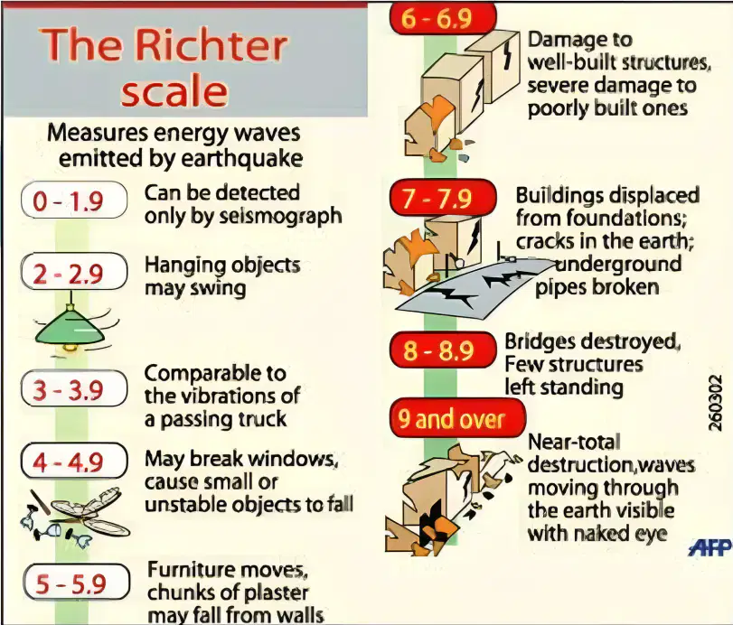
According to the Richter Scale, at what magnitude range comparable to vibrations of a passing truck?
a)
3.0-3.9
b)
4.0-4.9
c)
5.0 – 5.9
d)
6.0-6.9
16.
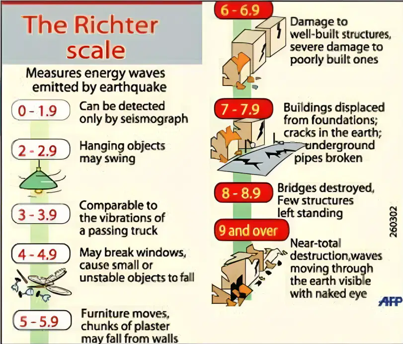
According to the Richter Scale, at what magnitude range hanging objects may swing?
a)
0 – 1.9
b)
3.0 – 3.9
c)
2.0 – 2.9
d)
4.0 – 4.9
17.
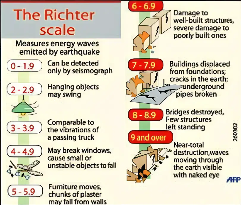
According to the Richter Scale, at what magnitude range damage to well-built structures, severe damage to poorly built ones?
a)
4.0 – 4.9
b)
5.0 – 5.9
c)
6.0 – 6.9
d)
7.0-7.9
18.
Two 6.8-magnitude earthquakes strike in two distinct locations: a crowded city with skyscrapers and a rural area with modest homes. Which region is most likely to sustain more damage?
a)
the city, since a higher population and taller structures make things riskier.
b)
the countryside, as there are fewer emergency personnel there.
c)
the countryside, because to its more robust soil base.
d)
The degree of damage will be equal in both places.
19.
Why do communities typically experience greater effects from earthquakes of higher magnitude?
a)
Stronger shaking and more extensive damage result from their increased energy release.
b)
Compared to smaller earthquakes, they are always closer to the surface.
c)
They always happen in places with a lot of people.
d)
Compared to smaller earthquakes, they stay longer.
20.
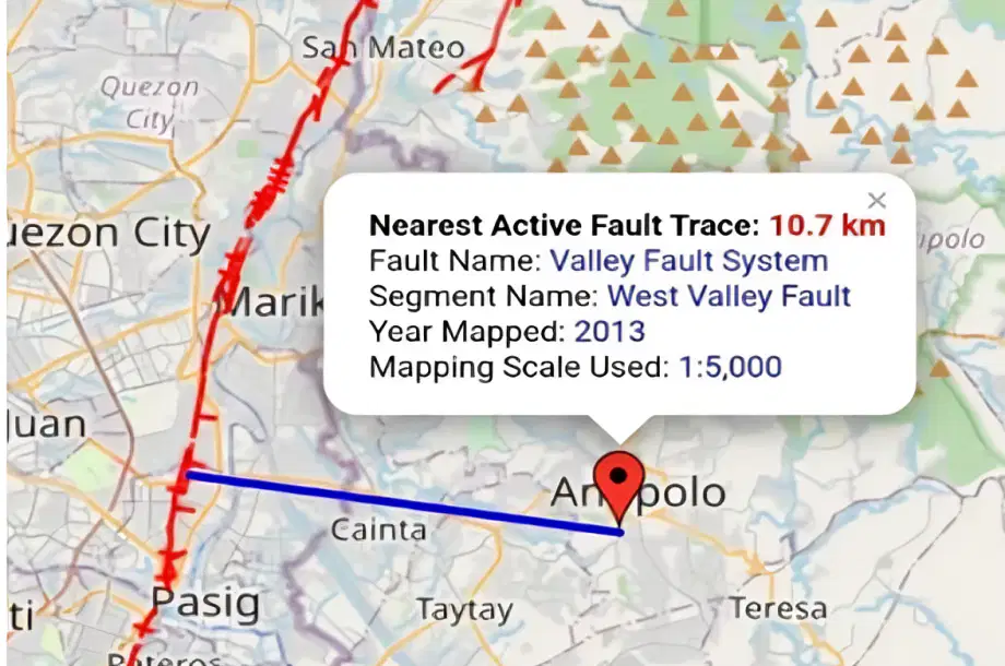
Based on the image, what is the nearest active fault to San Roque, Antipolo City?
a)
Central Fault System
b)
East Luzon Fault
c)
Marikina Fault
d)
West Valley Fault
21.
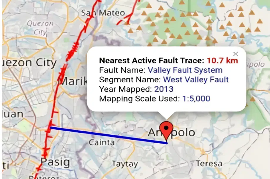
In what Year Mapped the nearest active fault trace in San Roque, Antipolo City?
a)
2021
b)
2013
c)
2023
d)
2031
22.
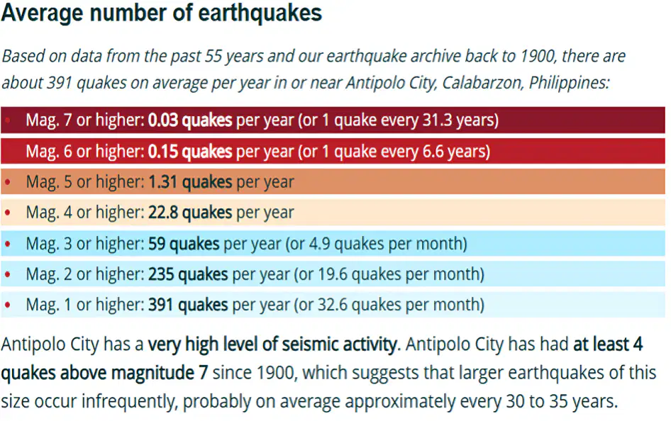
How often does an earthquake of magnitude 5 or higher occur in Antipolo City?
a)
1.31 quakes per year
b)
22.8 quakes per year
c)
59 quakes per year
d)
235 quakes per year
23.
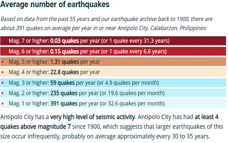
What may be concluded from historical data regarding the earthquake activity of Antipolo City?
a)
It has a high level of seismic activity.
b)
Every five years, there are large earthquakes.
c)
There aren't many earthquakes there every year.
d)
No earthquake larger than magnitude 6 has ever struck it
24.
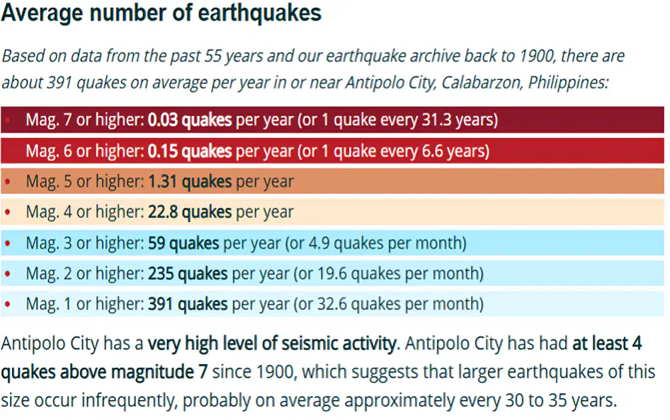
What is the estimated recurrence interval of a magnitude 7 or higher earthquake in Antipolo?
a)
Every 31.3 years
b)
Every 6.6 years
c)
Every 10 years
d)
Every 50 years
25.
Considering the location and topography of Antipolo City, What will most likely to happen when we experience the “BIG ONE”?
a)
Landslide
b)
Cracks on roads
c)
Tsunami
d)
Volcanic eruption
26.
What are the expected impacts on Antipolo City of an earthquake of magnitude 7.2 along the West Valley Fault?
a)
Building damage that ranges from moderate to severe, as well as landslides in locations with a slope.
b)
Since the city is distant from the fault, there won't be any discernible effects.
c)
Very little damage and maybe a little shaking.
d)
total devastation of the city.
27.
Why is the West Valley Fault a problem for Antipolo City residents?
a)
Destructive earthquakes have been known to occur there roughly every 400–600 years.
b)
It merely causes mild tremors that are not harmful.
c)
It is not dangerous and is positioned far away.
d)
According to scientists, it won't ever move again.
28.
If you are indoors during an earthquake, what is the safest action?
a)
Go outside right away.
b)
To get a better view, stand close to windows.
c)
Drop, cover, and hold, until the shaking stops.
d)
To get to the ground floor, take the lift.
29.
Where is the safest place to take cover during an earthquake?
a)
Near bookshelves and cabinets.
b)
Under a sturdy table or desk.
c)
Next to a refrigerator.
d)
Under a ceiling fan.
30.
What should you do right away after an earthquake?
a)
Look for injuries on both you and other people.
b)
Return to the house right away.
c)
Give friends and family a call to talk.
d)
Disregard emergency alerts.
31.
What are we going to do before an earthquake occurs?
a)
Fear and panic
b)
Contact the police.
c)
Check the house for any damage.
d)
Prepare for and secure your emergency needs.
32.
When there is an earthquake, which of the following should not be done?
a)
Remain calm.
b)
Enter the house.
c)
Do cove, duck, and hold.
d)
Share an earthquake on social media.
33.
After an earthquake, which is vital to remember?
a)
Don't go back inside the house or building right away.
b)
Give loved ones a call to see how they're doing.
c)
Listen to news about possible aftershocks and degree of damages.
d)
all of the answer is correct
34.
What has the potential to start a tsunami?
a)
underwater Landslide
b)
Underwater earthquake
c)
Volcanic eruption
d)
All of the above
35.
What is a typical sign that a tsunami is about to occur?
a)
Abruptly, seawater pulls back from the beach.
b)
Abruptly, the sky becomes clear.
c)
Winds abruptly shift their course.
d)
All of the above
36.
Where do the majority of tsunamis start?
a)
In the water, along tectonic plate borders
b)
In right next to big rivers
c)
In the midst of deserts
d)
Close to glaciers
37.
Why do tsunamis occur after some earthquakes but not after others?
a)
Only when the seafloor moves vertically due to an earthquake can enough water be displaced to create a tsunami.
b)
Only when a hurricane follows an earthquake may a tsunami occur.
c)
Every ocean earthquake inevitably results in a tsunami.
d)
Only during nighttime earthquakes do tsunamis occur.
38.
What should you do if you were on the beach and experienced intense earthquake shaking?
a)
Hurry to the water to see whether there are any fish on the bare bottom.
b)
Hold off until you receive a formal warning.
c)
Immediately move inland to higher ground
d)
Look for a boat and head out to sea.
39.
What is the primary factor of how much destruction tsunamis inflict on towns along the coast?
a)
The proximity of the shoreline community to the earthquake epicenter.
b)
Advanced warning systems are present in the impacted areas.
c)
how big the earthquake that caused the tsunami was.
d)
how frequently tsunamis occur in the area.
40.
Which Philippine government organization is in charge of earthquake and tsunami monitoring?
a)
Atmospheric, Geophysical and Astronomical Services Administration of the Philippines (PAGASA)
b)
Philippine Institute of Volcanology and Seismology, or PHIVOLCS
c)
Metro Manila Development Authority, or MMDA,
d)
Department of Health (DOH)
41.
How are potential tsunamis detected by PHIVOLCS?
a)
Using tsunami detection buoys, waves gauges, and seismographs
b)
By examining the ocean's wind speed
c)
By observing big waves close to the coast
d)
Through the observation of undersea volcanoes
42.
How can communities in the Philippines get alerts when a tsunami is approaching?
a)
Updates from NDRRMC and PHIVOLCS on social media
b)
Systems SMS alerts, TV, and radio
c)
Public address systems and emergency sirens
d)
All of the above
43.
What should you do in the event of a powerful earthquake in a Philippine seaside town?
a)
Don't wait for an official warning before evacuating to higher ground.
b)
Keep an eye out for large waves and stay close to the coast.
c)
Go inside a nearby building and remain there.
d)
Stay where you are and call for assistance.
44.
Why are Philippine tsunami warnings so important for disaster preparedness?
a)
They allow time for communities to move to safer locations.
b)
They aid in the study of ocean movements by scientists.
c)
They let fishermen get their boats ready.
d)
These stop earthquakes from occurring.
45.
How can local communities and the Philippine government better prepare for tsunamis in the future?
a)
Boost emergency communication and early warning systems.
b)
Organize frequent education programs and tsunami drills.
c)
Create hazard maps and evacuation routes for tsunamis.
d)
All of the choices are correct.
46.
Which of the following best sums up the relationship between the sun and the atmosphere?
a)
The sunlight travels through space and enters the Earth’s atmosphere, trapped and stays to warm up the planet.
b)
Sunlight brings warmth to the atmosphere and the atmosphere warms the earth.
c)
The atmosphere receives messages from sunlight to warm the planet.
d)
Together, sunlight and UV radiation penetrate the atmosphere.
47.
Which of the following statements DOES NOT describes the reason for the thermosphere's extremely high temperature?
a)
due to its closeness to the sun's rays.
b)
due to the ionosphere that exists there.
c)
due to the fact that it absorbs sun light with tremendous energy.
d)
Because it already merges to the space.
48.
How significant is Earth's atmosphere, and what role does it play?
a)
It is in charge of the tides.
b)
It stops heat from rapidly escaping into space.
c)
The planet's heat gain or loss is not taken into consideration.
d)
In order to cool the earth, it permits heat to swiftly escape into space.
49.
What prevents heat from escaping Earth and from being re-emitted?
a)
Greenhouse gas emissions from natural sources
b)
Greenhouse gases produced by humans
c)
Radiation from the sun
d)
The atmosphere
50.
What will happen to earth to the if the gases cannot escape because of greenhouse gases?
a)
It will intensify the greenhouse effect.
b)
They'll send it back to Earth.
c)
The Earth will get warmer as a result.
d)
Every response is accurate.
51.
Which of the following greenhouse gases that are released into the atmosphere greatly intensifies the greenhouse effect?
a)
Ozone
b)
Methane
c)
Carbon Dioxide
d)
Chlorofluorocarbons
52.
Which of the following best describes how the seasons change?
a)
The tilt of the Earth is 23.5 degree
b)
On its axis, the Earth rotates.
c)
The planet is spherical and evolving.
d)
The atmosphere of Earth is warming.
53.
Southern hemisphere is tilted away from the sun. What season does it experience?
a)
Winter
b)
Spring
c)
Summer
d)
Autumn
54.
In the month of June, the southern hemisphere is titled away from the sun. Which sentence is NOT TRUE about the climate in this region?
a)
The season in the southern hemisphere three weeks before is autumnal.
b)
There is a longer nighttime in the southern hemisphere in June.
c)
The region is experiencing a summer solstice.
d)
The climate in this region is extreme cold
55.
According to a scientist, seasonal variations would still occur if Earth's tilt were 0 degrees rather than 23.5 degrees. How would you assess this claim?
a)
Disagree, because Earth's seasons are caused by its axial tilt, not its distance from the Sun.
b)
Agree, because Earth's distance from the Sun changes throughout the year.
c)
Agree, because the Moon’s gravity would still create seasonal variations.
d)
Disagree, because Earth’s rotation is what causes the seasons, not the tilt.
56.
Which essential elements should be present in a model that illustrates how the Earth's tilt impacts daylight hours?
a)
flat Earth model with a light source that moves.
b)
Earth in a stationary position with the Sun represented by a single light source.
c)
a rotating Earth that is not tilted to reveal the same amount of sunshine everywhere.
d)
A slanted Earth orbiting a stationary Sun that displays varying sunlight angles throughout the year
57.
A school intends to design a practical experiment to demonstrate how the tilt of the Earth impacts the duration of daylight. Which configuration would work best?
a)
observing how light falls on various regions of the Earth throughout the year using a tilted globe and a lamp to symbolize the Sun.
b)
To illustrate rotation, spin a basketball under a light source while maintaining its upright position.
c)
examining the movement of light across a spinning top by shining a torch on it.
d)
focusing sunlight onto an Earth map with a magnifying lens.
58.
What is the contribution of the sun to the movement of air?
a)
The sun warms up the land while the land warms up the air above it is causing it to move up because it is less dense.
b)
The sun warms the water and evaporates it. The vapor causes a movement of hot and cold air in the atmosphere.
c)
The sun warms up the earth, allowing the heat to stay on it and continue the natural cycles.
d)
All the sentences explain the contribution of the sun to the movement of air.
59.
Which of these describes how air moves during a sea breeze?
a)
Land is replaced by cold air as hot air rises from the sea.
b)
Cold air replaces the hot air that rises from the land.
c)
The water is warmed by hot air, which also cools the air and creates breezes.
d)
The land is warmed by hot air, which also causes the air above it to cool and become windy.
60.
Which of the following explains the occurrence of ITCZ?
a)
Converging winds from poles
b)
Band of clouds at the equator
c)
Thunderstorms
d)
All of the answers are correct
61.
When air particles in the atmosphere are heated, the temperature increases. Does increase in its temperature cause increase in its density?
a)
A. No, because the higher the temperature of air the lesser its density.
b)
B. No, because the density of air is not affected by its temperature at all.
c)
C. Yes, because the density of air will increase if its temperature increases too.
d)
D. Yes, because the density and temperature of air are directly related to each
e)
other.
62.
What would likely happen to sea breezes if sunlight increased as a result of global warming?
a)
As the temperature differential between the land and the water widens, sea breezes will intensify.
b)
Warmer land surfaces would obstruct airflow, weakening sea breezes.
c)
As temperatures rose, sea breezes would completely vanish.
d)
Sea breeze patterns are unaffected by solar radiation.
63.
What supplies would be necessary if you were creating a presentation in the classroom to illustrate how land and sea breezes work?
a)
To visualize air movement, use a heat lamp, a bowl of water, a bowl of sand, and incense smoke.
b)
Air pressure and temperature are measured using a barometer and a thermometer.
c)
a fan and a rotating globe to symbolize the rotation of the Earth.
d)
a vacuum-sealed container to demonstrate air circulation.
100 %

