
 Worksheets
APES Unit 4 Test Review
Total questions: 150
Worksheet time: 3hrs 5mins
Which type of boundary results in the creation of mountains, island arcs, earthquakes, and volcanoes?
Convergent
Divergent
Transform
Which type of boundary results in the creation of rift valleys, volcanoes, seafloor spreading, and earthquakes
Convergent
Divergent
Transform
Transform boundaries mainly result in
Island Arcs
Seafloor spreading
Earthquakes
Mountains
Which of the following occur when stress overcomes a locked fault, releasing stored energy.
Rift Valleys
Volcanoes
Mountains
Earthquake
The huge blocks of the earth's crust that slide around slowly are called
Volcanoes
Tectonic Plates
Rift Valleys
Mid ocean ridges
As oceanic plates move apart rising magma forms new oceanic crust this is known as
Volcanoes
Seafloor spreading
Mid-ocean ridges
Mountains

Where oceanic plates meet continental plates, old oceanic crust is pulled downward and the heavier oceanic crust slides underneath the lighter continental plate. This is called
Seafloor spreading
Abduction
Subduction
Convection
Mountains on the ocean floor created by Sea Floor Spreading
Sea Floor spreading
Subduction
Volcanoes
Mid-ocean ridges
when a plate moves over a hot spot and the heat form the rising mantle plume will melt the crust
Volcanoes
Mountains
Earthquakes
Subduction
When plates move away from each other and creates new lithosphere
Divergent plate boundary
Convergent
Transform
When plates move toward one another and collide.
Divergent
Convergent
Transform
When plates slide past one another.
Divergent plate boundary
Convergent plate boundary
Transform plate boundary
The San Andreas fault is which type of plate boundary?
Divergent plate boundary
Convergent plate boundary
Transform plate boundary

In the diagram, A represents a
Convergent plate boundary
Divergent plate boundary
Transform plate boundary

In the diagram, at which letter are you most likely to have island arcs.
A
B
C
D

Seafloor spreading, rift valleys, volcanoes, and earthquakes will be found at what letter
A
B
C
D

What type of boundary is shown in the picture
Convergent plate boundary
Divergent plate boundary
Transform plate boundary

In the diagram, C represents which type of plate boundary
Convergent
Divergent
Transform
The region where two lithospheric plates meet
Continental Drift
Plate tectonics
Plate Boundaries
Which layer of the Earth consists of tectonic plates?
asthenosphere
mantle
mesosphere
lithosphere
Tectonic plates “float” on
the lithosphere
the mantle
the ocean
the asthenosphere

What type of boundary is shown in the diagram?
Divergent
Convergent
Transform

What type of boundary is shown in the diagram?
Divergent
Convergent
Slide/Transform

What type of boundary is shown in the diagram?
Divergent
Convergent
Slide/Transform


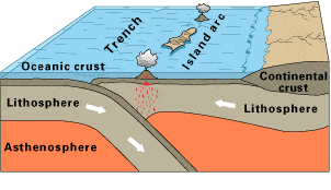
Observe this diagram of a plate boundary. One statement BEST describes what is happening. It is that
the oceanic crust is melting.
the denser ceanic crust is subducting under the less dense oceanic crust
volcanic islands are forming.
the tectonic plates are moving away from each other.
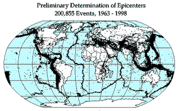
Earthquake epicenters (center of where the earthquakes started) were mapped for a 35 year period in the diagram above. The black dots indicate these epicenters. The black dots appear along what feature on Earth?
hot spots
plate boundaries
rift zones
sea floor spreading
The San Andreas Fault in California is known as an active earthquake area. What type of
boundary is it?
Converging
Diverging
Transform
Sea Floor Spreading


The rate at which water flows through the soil is called soil percolation or ______.
Groundwater
Permeability
Soil Pores
Porosity

The layer(s) of soil in which most of the humus and soil organisms are contained:
1- leaf litter, horizon O
2- topsoil, horizon A
3- subsoil, horizons B and C
1 only
2 only
1 and 2 only
2 and 3 only
1, 2, and 3


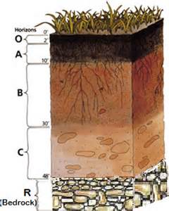
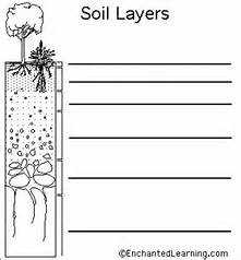
Which horizon contains clay, silt, and minerals, and is commonly referred to as subsoil?
Horizon A
Horizon B
Horizon C
Horizon D or R
Porosity is a measure of void space in a soil sample. Larger soil particles have larger void spaces. Smaller soil particles have smaller pore spaces, but a greater number of them, which leads to higher surface tension and higher % porosity. With this is mind, which statement is true:
Sandy soil has a higher porosity than clay soil
Sandy soil has a higher porosity than silty soil
Clay soil has a higher porosity than sandy soil
Porosity is directly proportional to soil particle size
What is the largest component of soil by percentage?
Air
Water
Mineral Particles
Organic Matter
Soil is formed from decaying organic matter from 'above' and _______ from 'below'.
weathered parent bedrock material
mineral particles
water
air
Which of the following is an example of parent material that is nutrient-poor?
A) Quartz
B) Calcium carbonate
C) Limestone
D) Sandstone
The steeper the landscape, the ______ the erosion.
lower
higher
same
none
Which of the following is a service provided by soil organisms?
Increasing soil temperature
Breaking down toxic materials
Reducing soil porosity
Increasing soil acidity
Fill in the blank: In the soil horizon diagram, the layer labeled 'A horizon' is also known as ______.
Topsoil
Subsoil
Bedrock
Parent material
What is the percent of clay in a soil sample with 10% sand and 83% silt?
7%
10%
17%
83%
_____ is the smallest soil particle.
Sand
SIlt
Clay
This soil horizon is referred to as the "sub-soil"
A Horizon
B Horizon
C Horizon
R Horizon

What soil texture will I have with 15% clay, 25% sand, and 60% silt?
Loam
Silty, clay, loam
Sandy loam
Silt loam
This soil particle is slow draining.
Sand
Silt
Clay
This is needed for movement of water and water holding.
Air
Soil texture
Pore space
Soil tilth
This soil particle has medium water drainage qualities.
Sand
Silt
Clay
Students want to determine the impact of soil erosion from the development of new housing. They plan to measure the density of a species of algae growing along the bottom of a river that flows through their town. The town is built in a heavily forested area, but a large area of trees along the river was recently clear-cut to allow for the construction of a new housing development, which has caused exposed soil to wash into the river. The river flows north to south through the town and is still forested both up- and downstream of the town.
Which of the following is the dependent variable in the study?
The tract of land that was clear-cut for the housing development
A tract of land in a heavily forested area outside of town
The density of a species of algae growing along the bottom of the river
The flow rate of the river from north to south
Students want to determine the impact of soil erosion from the development of new housing. They plan to measure the density of a species of algae growing along the bottom of a river that flows through their town. The town is built in a heavily forested area, but a large area of trees along the river was recently clear-cut to allow for the construction of a new housing development, which has caused exposed soil to wash into the river. The river flows north to south through the town and is still forested both up- and downstream of the town.
Which of the following explains the variable that would be the best for students to measure to determine the direct impact of soil erosion caused by the construction project on the river?
Water temperature, because a decrease in shading in the area would indicate an increase in soil erosion.
Nutrient levels, because a decrease in nitrogen and phosphorus would indicate an increase in soil erosion.
The pH level, because an increase in pH would indicate an increase in soil erosion.
Turbidity, because a decrease in water clarity would indicate an increase in soil erosion.

An environmental engineer wants to examine the permeability of different soils to determine the best natural containment system to protect groundwater from pollutants. The engineer tests four different soil samples, places them into a wet column, and pours 50mL of water over each sample. The engineer records the total amount of water that moves through the column as well as the total amount of time for the water to fully percolate through the soil. The data from the study are shown below.
Which of the following best describes the independent variable in this research design?
The sample of material chosen as the potential container material is the variable being tested, so it is the independent variable.
The flow time, which is related to the porosity of each sample, is the variable that is measured, so it is the independent variable.
The total volume of water recovered is most likely to be affected by human error and is the variable with the largest range of values, so it is the independent variable.
The permeability of each soil sample, which is determined by dividing the total volume of water recovered by the flow time, is the variable that is calculated, so it is the independent variable.
An environmental engineer wants to examine the permeability of different soils to determine the best natural containment system to protect groundwater from pollutants. The engineer tests four different soil samples, places them into a wet column, and pours 50mL of water over each sample. The engineer records the total amount of water that moves through the column as well as the total amount of time for the water to fully percolate through the soil. The data from the study are shown below.
Which of the following best describes why the engineer chose to calculate the permeability of the soil sample in the experimental design in order to evaluate a natural containment system to protect groundwater?
Soils that have high permeability would best help protect groundwater because they would allow for faster recharge of the aquifer.
Soils that have high permeability would best help protect groundwater because they have higher rates of nutrient and pesticide leaching.
Soils that have low permeability would best help protect groundwater because the soil traps pollutants so that chemical and biological breakdown can occur.
Soils that have low permeability would best help protect groundwater because the large pore spaces would provide space for pollutants to attach and would have rapid percolation of water.

Students sampled several different gardens near their school and measured the percentages of silt, sand, clay, and humus content present in each sample. Their results are shown in the table below.
Based on the data in the table above, which of the following samples would be the most prone to becoming waterlogged?
Sample A
Sample B
Sample C
Sample D
Students want to determine the impact of soil erosion from the development of new housing. They plan to measure the density of a species of algae growing along the bottom of a river that flows through their town. The town is built in a heavily forested area, but a large area of trees along the river was recently clear-cut to allow for the construction of a new housing development, which has caused exposed soil to wash into the river. The river flows north to south through the town and is still forested both up- and downstream of the town.
Which of the following would be the best control sample for the study?
A sample of water collected just downstream of the southern forest
A sample of water collected just downstream of the housing development
A sample of water collected just downstream of the northern forest
A sample of distilled water


Which wind system is closest to the equator?
Doldrums
Westerlies
Polar easterlies
Trade winds
ENSO events take place in which ocean basin?
Atlantic
Indian
Pacific
Arctic
Why does the Earth have seasons?
Tilt of the Earth on its axis
Earth's shape
Earth's rotation around the Sun
Earth's rotation on its own axis

Which month has the highest precipitation?
July
August
September
June
In which atmospheric layer do all the pressure, wind and precipitation changes occur?
Troposphere
Mesosphere
Thermosphere
Stratosphere
The SECOND most common gas in our atmosphere is ____.
N
O
Ne
Ar

What layer of the atmosphere absorbs harmful ultraviolet radiation?
Troposphere
Stratosphere
Mesosphere
Thermosphere
This phenomenon occurs when a coastal mountain range blocks the passage of precipitation to the leeward side of the mountains.
thermal inversion.
Coriolis effect.
rain shadow effect.
urban heat island effect.
ENSO.
This air circulation pattern occurs between 0 degrees latitude and 30 degrees latitude.
Hadley cell
Ferrell cell
polar cell
Coriolis effect
The Sun’s radiation provides the energy for all of the following EXCEPT
plant growth
ocean currents
hurricanes
plate tectonics

I. variation in the angle of sunlight that reaches Earth
II. variation in the amount of surface area over which the Sun's rays are distributed
III. variation in the amount of sunlight reflected from clouds
Which wind system is closest to the equator?
Doldrums
Westerlies
Polar easterlies
Trade winds
ENSO events take place in which ocean basin?
Atlantic
Indian
Pacific
Arctic
Why does the Earth have seasons?
Tilt of the Earth on its axis
Earth's shape
Earth's rotation around the Sun
Earth's rotation on its own axis
This phenomenon occurs when a coastal mountain range blocks the passage of precipitation to the leeward side of the mountains.
thermal inversion.
Coriolis effect.
rain shadow effect.
urban heat island effect.
ENSO.
Why we have seasons
the tides
Earth's tilt
sun's rotation around the Earth
Milankovitch cycles
78% of the Earth's atmosphere is ___________ and 21% of the Earth's atmosphere is _____________.
Oxygen, Nitrogen
Nitrogen, Oxygen
Nitrogen, Carbon Dioxide
Oxygen, Carbon Dioxide
In what layer of the atmosphere do all weather events occur?
Stratosphere
Exosphere
Mesosphere
Troposphere
As altitude increases, air pressure....
Increases
Decreases
Stays the same
Goes up and down
The ozone layer is a sublayer of the ________ layer.
Troposphere
Stratosphere
Exosphere
Mesosphere
Why is the ozone layer vital to life on Earth?
Planes fly in the ozone layer
It is made up of oxygen (O2)
It shields the Earth from ultraviolet (UV) rays from the sun
It causes clouds to be created
In which layer of the atmosphere do meteors burn up?
Troposphere
Mesosphere
Thermosphere
Exosphere
This layer is the outermost layer of the atmosphere. Satellites orbit the atmosphere in this layer.
Exosphere
Mesosphere
Thermosphere
Ozone Layer
What is the order of the layers of the atmosphere, starting with the layer closest to Earth's surface?
Stratosphere, Troposphere, Exosphere, Mesosphere, Thermosphere
Troposphere, Stratosphere, Mesosphere, Thermosphere, Exosphere
Troposphere, Stratosphere, Mesosphere, Exosphere, Thermosphere
Troposphere, Stratosphere, Thermosphere, Exosphere, Mesosphere
What layer of the atmosphere has the highest air pressure?
Troposphere
Stratosphere
Exosphere
Mesosphere
What layer of the atmosphere has the lowest air pressure?
Troposphere
Stratosphere
Exosphere
Mesosphere
Which explanation correctly describes the greenhouse effect?
The process of the atmosphere keeping the Earth's surface dense
The process of the atmosphere trapping the sun's radiation, and making the Earth warm and livable for humans
The process of the atmosphere keep us from floating into space
The process of the atmosphere reflecting all of the Sun's heat back into space
Which atmospheric layer is the Aurora Borealis located in?
Troposphere
Mesosphere
Exosphere
Thermosphere
Adiabatic cooling is the cooling of the air because..
as elevation increases and air expands looses energy
of the uneven distribution of heat on Earth
the air blows over cool surface and cools the air
air cools as it sinks down to Earth's surface as it condenses
When water condenses or freezes, latent energy is released causing the surrounding air to become..
Warmer
Cooler
When water melts or evaporates, latent energy is absorbed causing the surrounding air to become...
cooler
warmer
Relative humidity is based off the _____________ point of the area and is based off the __________ of water in the air.
Dew, Percentage
Dew, Total amount
Saturation, Percentage
Saturation, Total Amount
Saturation is influenced what two factors?
Temperature
Amount of water in the air
Elevation
Dewpoint
The type of precipitation

Heat transfer by convection is caused by differences in what two things:
Thickness and material
Weight and electricity
Temperature and density
Heat transfer by convection is caused by differences in what two things:
Thickness and material
Weight and electricity
Temperature and density
Select the word that is not part of the word Insolation.
Convection
Radiation
Solar
Incoming
THE FALL OF TEMPERATURE WITH INCREASING HEIGHT IN TH TROPOSHERE
INSOLATION RATE
NORMAL LAPSE RATE
La Nina would produce all of the following effects EXCEPT
more Atlantic hurricanes
warmer and drier winters in the southwestern and southeastern United States
decreased fish schools due to less upwelling
wetter winters in the Pacific Northwest region of the United States
Most of Earth’s deserts are approximately 30º north and south latitudes because these latitudes are characterized by
a slow moving jet stream
descending dry air currents
enhanced solar radiation
predominately low atmospheric pressure
Which of the following surfaces would have the lowest albedo?
black topsoil
desert
ocean water
snow

Which of the following gives the correct order of events leading to the rain shadow effect shown below?
Warm, moisture-laden air from a body of water moves toward the mountain. As the air rises it cools and water vapor condenses, causing precipitation which removes water vapor from the air. The now dry air descends on the other side of the mountain, creating a desert climate.
Warm, moisture-laden air from over a body of water moves toward the mountain. As the air rises it cools and water vapor condenses, but since it does not fall a desert climate is produced.
Cool, moisture-laden air from over a body of water moves toward the mountain. As the air rises it warms and water vapor condenses, causing precipitation which removes water vapor from the air. The now dry air descends on the other side of the mountain, creating a desert climate.
Cool, moisture-laden air from over a body of water moves toward the mountain. As the air rises it warms and water vapor condenses, but since it doe not fall a desert climate is produced.

