
 Worksheets
SST Term 1 Revision Test
Total questions: 40
Worksheet time: 20mins
_______________is a low point between two ranges that is used as a route between
Valley
Mountain Pass
Edge
Hairpin road
________ is a fresh water stream that feeds into larger stream of river.
Distributaries
Tributaries
Spring
Marsh
A large part of Indus Basin is in?
Kashmir & Punjab
Punjab & Haryana
Haryana & UP
Haryana & Bihar
________________ is one of the plateaux of the Peninsular Plateau.
Deccan Plateau
Eastern Ghats
Western Ghats
Northern Plain
Some sections of desert in Rajasthan get water from
Indira Gandhi Canal
Sutlej Basin
Narmada
Tapi
(a) is capital city of Lakshadweep?
(a) is the capital of Andaman & Nicobar
The Great Indian Desert is also known as ___________
Sahara Desert
Empty Quarter
Thar Desert
Gobi Desert

A landmass bound by sea on three sides is referred as
Coast
Island
Peninsula
Ghat

Lakshadweep is located in
Arabian sea
Bay of Bengal
Indian ocean
Atlantic ocean
The Himachal is also known as
Middle Himalayas
Outer Himalayas
Greater Himalayas
The main occupation of Northern plains?
Fishing
Mining
Farming

The ________________ is the world's highest peak
Mount Abu
Himalayas
Kachenjunga
Mount Everest
India is a part of .................... continent
Asian
African
Australian

Identify the type of landform.
Mountains
Islands
Desert
Plains
The shape of Deccan Plateau is-
Rectangular
Triangular
Round
Oval
A piece of land that is surrounded by water from all sides-
Mountain
Plateau
Desert
Island

A place where land meats the sea?
Island
Coast
Plateau
Desert
Which of the following state is not coming under Northern plains?
Punjab
Haryana
Uttar Pradesh
Andhra Pradesh
Sand hills formed in a desert are called ___________.
sand dunes
sandhills
sandstorms
loo
Strong winds that blow in a desert and shift sand from one place to another are called ___________________.
storms
sandstorms
loo
sand dunes
An area in a desert where water is available and agriculture is carried out is called an ________________.
oasis
caravan
lake
banjara
The fine silt deposited in the valley is called ____________________.
alluvium
magnesium
calcium

There are ______________ physical divisions in India.
7
9
6
Himadri is known as ____________________.
Himachal
Sikkim
Greater Himalayas
Shivalik
Slow moving rivers of ice are called _____.
ice bergs
blizzards
glaciers
The Himalayas can be divided into ------ parallel mountain ranges.
Three
Four
Two
early humans lived in houses like ours ?
true
false
early humans ate
raw food
fruits
seeds
all of these
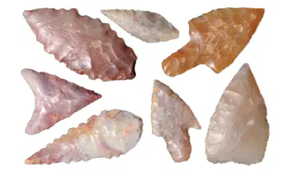
Use the image to answer the question.
How did hunter-gatherers use the tools shown in this image?
to travel long distances
to make cave drawings
to pick wild vegetation
to hunt large animals

Which term BEST describes the image?
Shelter
Tools
Weapons
Artifact

They used ________________ for clothes.
animal skins
leaves
branches
tree bark
What does it mean if something is ancient?
It's very old
It's found underground
It's made in a factory
It is the remains of an animal from long ago



