
 Worksheets
Checkpoint 2: The World in Spatial Terms (G.1.1)
Total questions: 82
Worksheet time: 1hrs 7mins
Which answer best describes how latitude influences the relationship between people and places on Earth?
A. People generally prefer to settle in cool latitudes with short growing seasons.
B. People generally prefer to settle in warm latitudes with long growing seasons.
What is “15°N” used to identify?
the equator
a line of latitude
a line of longitude
the prime meridian
Which of these identifies a line of longitude but not a line of latitude?
45°S
135°E
the equator
60°N, 55°W
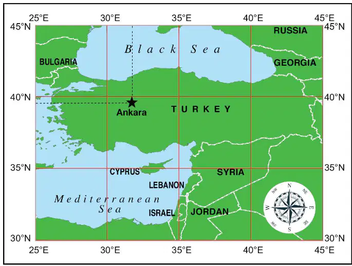
What is the latitude and longitude of Ankara?
32°N, 35°E
35°N, 40°E
39°N, 32°E
43°N, 28°E
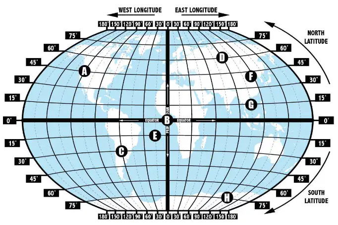
Match each set of coordinates to the absolute location on the map. Write the letter from the map next to the correct coordinates.
C
30°S, 60°W
D
60°N, 90°E
E
15°S, 15°W
G
15°N, 105°E
F
40°N, 116°E
What are the six essential elements of geography? (Choose 2)
Human Systems
Agriculture
The Uses of Geography
Cartography
Which of these is the BEST way to describe the six essential elements of geography?
a method of ensuring that environment and society do not affect each other
an organizing framework to understand the world and its people
a way to determine the absolute location of any place on Earth
how weather forecasters predict changes in the weather
Match each of the six essential elements of geography to the short summary of why it is important.
.It deals with the processes through which human populations affect each other and influence the division and control of Earth.
Human System
It deals with the processes, such as climate, that influence physical characteristics of Earth’s surface.
Physical systems
Many different things make up Earth’s physical and human characteristics, so people divide the Earth into regions with shared characteristics to help understand it better.
Places and Regions
It can be used to interpret and understand past and present events.
The Uses of Geography
There is a strong connection between the environment of Earth and the human society on it.
Environment and Society
What are the cardinal directions?
north, northeast, northwest, south, southeast, and southwest
east, northeast, southeast, west, northwest, and southwest
north, northeast, northwest, south, southeast, and southwest
What are the intermediate directions?
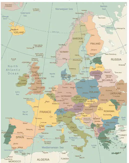
Which type of map BEST describes this map?
Special purpose map
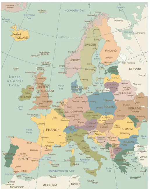
How might this map be used?
Learn the names of important cities
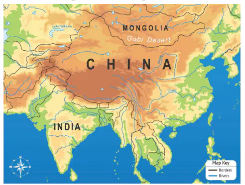
Which type of map BEST describes the map shown in the image?
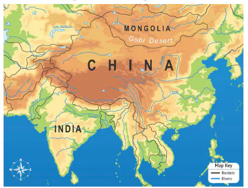
How might this map be used?
Learn the names of important cities
Learn about important landforms
Learn the average annual rainfall
Learn when people moved to the area
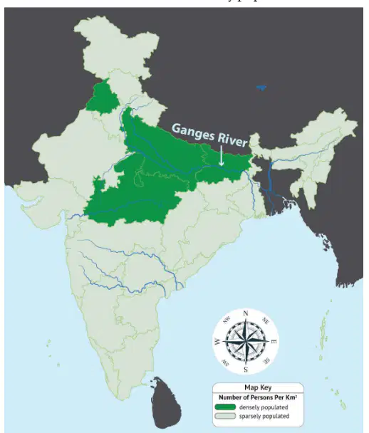
Use the choropleth map to determine which part of ancient India was most densely populated.
western India
eastern India
southern India
northern India
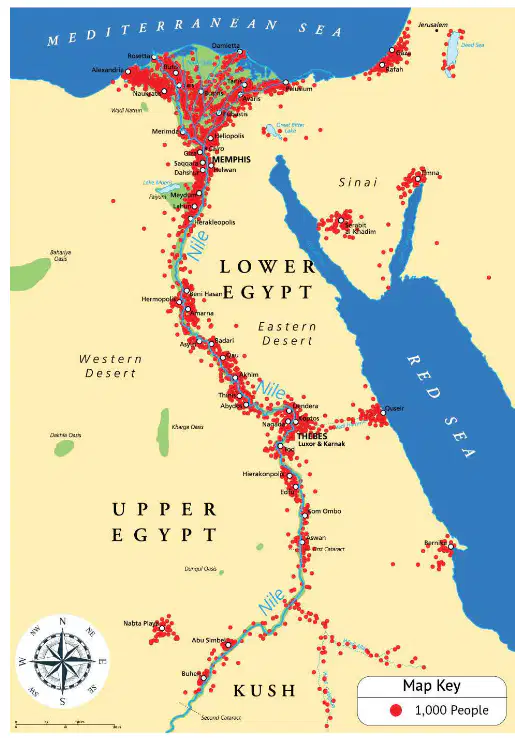
Which physical feature of ancient Egypt was most of the population centered around?
In which scenario is it most useful to have a globe instead of a map?
When you need to see the whole world accurately
When you need to see the details of a small area
When you need to know the capital city of Florida
When you need to know the population of a region
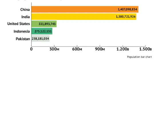
According to the bar chart, what is the most populated country in the world?
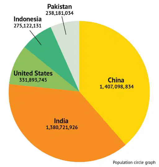
According to the circle graph, what is the third most populated country in the world?
Pakistan
China
India
Why do geographers use aerial photography?
Aerial photographs are taken from outer space, so they provide geographers with a view of entire continents at once.
It is easy to take an aerial photograph to see what is nearby in case a geographer gets lost while making a map.
Sometimes online maps do not seem accurate, so geographers use aerial photography to confirm what they see or share online.
Aerial photographs show what things look like from above, and can help geographers see things that are not visible from the ground.
Which of these is NOT a benefit of satellites or satellite imaging?
Satellites can provide pictures of what Earth looked like in the past.
Satellite images are very accurate.
Satellite images provide a view of Earth’s geography at a large scale.
Satellites can provide valuable data about climate, physical features, vegetation, and more.
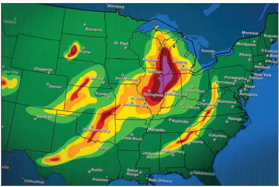
How would you use an online map like this one?
To know what the weather is like
To know what the population density is
To know what the temperature is
To know what the population density is
Which is most useful for determining an exact location and how to get there?
global positioning system
3D mapping
aerial photograph
physical map
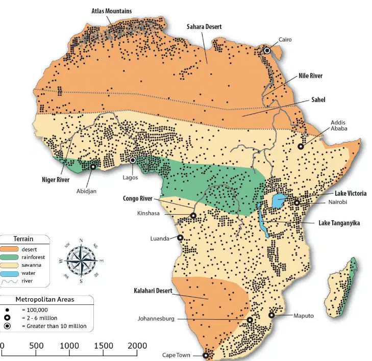
Use the map scale to estimate the distance between Cairo and Addis Ababa.
1,000
500
1,200
1,500
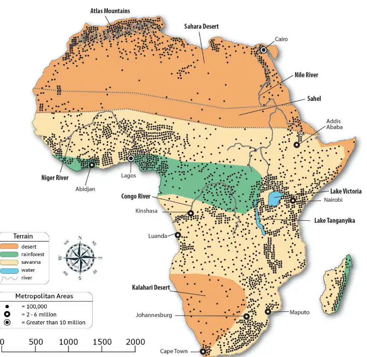
Which intermediate direction do people travel from Addis Ababa to Cairo?
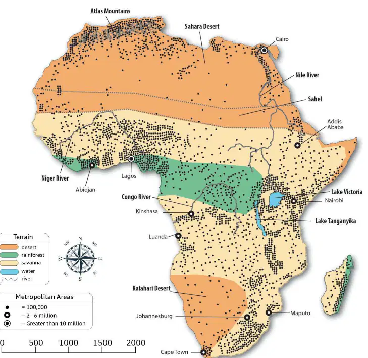
Which type of map BEST describes this map?
Special purpose map
Compass
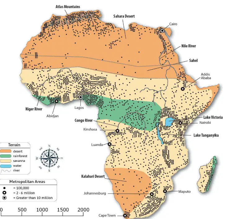
What kind of information can you gather from this map? (Choose 2)
population density
national borders
average temperature
major landforms
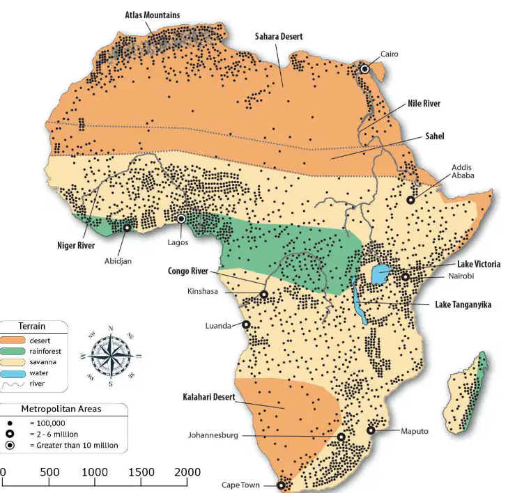
Which example BEST demonstrates a way this map could be used?
This map could be used to show a connection between major landforms and where people live.
This map could be used to show a connection between major landforms and national borders.
This map could be used to show a connection between national borders and where people live.
This map could be used to show a connection between the average temperature and where people live.
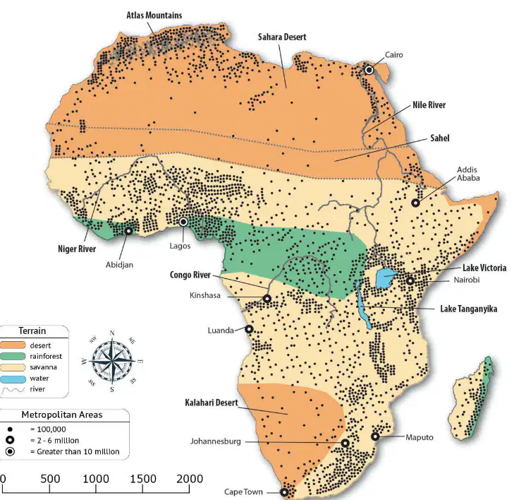
Which geographic feature dominates most of central and southern Africa?
savanna
desert
rainforest
water
What are the seven main bodies of land on Earth?
continents
empire
countries
regions
What is the Middle East an example of?
continents
empires
countries
regions
What geographic division can contain different types of land and culture but is only defined by political boundaries?
a continent
a natural wonder
a country
a region
Which of these is the smallest geographic division?
a continent
a city
a county
an empire
Match each geographic division to the short description that BEST fits it.
a small political division, made by an
independent entity whose political
reach extended to neighboring rural, or
agricultural, areas outside of itself
city-state
a very large political division made of
different areas and cultures but under
the same overall rule
empire
a large political division governed by a
monarch who typically held absolute
power
kingdom
a political division that was part of a
larger kingdom or empire
providence
Put these geographic divisions in order from largest to smallest. Number the largest division as 1, the next largest as 2, and so on.
empire
1
kingdom
2
province
3
city-state
4
Which statement accurately describes natural wonders?
Natural wonders were religious centers of early civilizations.
Natural wonders are areas of the world we do not understand.
Natural wonders are impressive natural features of the world.
Natural wonders were created by some of the earliest civilizations.
Which of these is considered a natural wonder?
Eurasia
the Roman Empire
the Middle East
the Himalayan Mountains
How did ancient farmers compensate for the scarcity of water in the Middle East?
They made the world’s first irrigation systems.
They used seasonal crop rotations.
They developed terrace farming.
They returned to hunting and gathering instead of farming.
How did ancient farmers compensate for the scarcity of flat land in China?
They developed terrace farming.
They used seasonal crop rotations.
They made the world’s first irrigation systems.
They returned to hunting and gathering instead of farming.
Which statement best describes natural disasters?
Natural disasters plagued many ancient civilizations and still present a threat today.
Natural disasters plagued many ancient civilizations but do not present a threat today.
Natural disasters are not a threat to human civilization because they only affect nature.
Human civilizations often remove trees and bushes in order to make room for buildings or farmland. What type of human impact on the environment is this?
deforestation
desertification
erosion
natural disaster
Why do civilizations typically develop near bodies of water?
water is necessary for survival
areas with water have more mild climates
water is useful for transportation and trade
water scares away most dangerous animals
Match each civilization with the body or bodies of
water it developed by.
Ancient China
Huang He
Ancient Egypt
Nile River
Ancient India
Ganges River and Indus River
Mesopotamia
Euphrates River and Tigris River
How did the Nile River influence the development of ancient Egypt?
Ancient Egypt focused on farming along the Nile.
Ancient Egypt focused on expanding across the Sahara Desert.
Ancient Egypt focused on its other natural resources instead.
Ancient Egypt focused on building a powerful navy along the Nile.
Why did ancient civilizations develop networks of highways, waterways, and other transportation linkages?
to prevent cultural diffusion
to make it easier to fight wars
to increase their own isolation
to make trade faster and easier
Geography can both invite and limit interaction between civilizations.
True
False
How did the geographic boundaries of ancient China influence its interaction with other regions and cultures?
The Himalayan Mountains made overland travel difficult, so ancient China was isolated.
The Himalayan Mountains were a natural wonder that many people came to see, so ancient China had lots of trade.
How did the geographic boundaries of ancient Greece influence its interaction with other regions and cultures?
The Mediterranean Sea made travel harder, so ancient Greece became isolated.
The Mediterranean Sea made travel easier, so ancient Greece developed a large trade system.
The religion of ancient Rome was heavily influenced by the religion of ancient Greece. What is this an example of?
cultural conquest
cultural limitation
cultural excavation
cultural diffusion
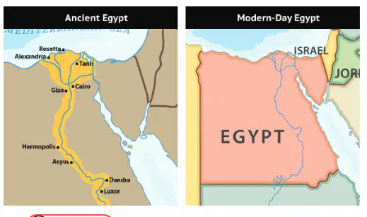
Is modern-day Egypt larger or smaller than ancient Egypt?
larger
smaller

Is modern-day Italy larger or smaller than ancient Rome?
smaller
larger

Is modern-day Greece larger or smaller than ancient Greece?
smaller
larger
How does education help increase economic growth?
education encourages technological breakthroughs
educated and skilled workers can perform tasks more efficiently
education makes technological breakthroughs unnecessary
educated people can make their own goods so they do not need to trade
Which of these is not a factor that increases economic growth?
education
religion
productivity
technology
In a traditional economy how are economic decisions made?
by governing leaders
by custom and historical precedent
by supply and demand
In a command economy how are economic decisions made?
by governing leaders
by custom and historical precedent
by supply and demand
Which economic system is identified by central ownership of resources?
command economy
traditional economy
market economy
Which is the oldest economic system?
command economy
traditional economy
market economy
In a traditional economy, people will typically trade or ________ for goods rather than use money.
pay with a check
use a credit card
Imagine you are given $10 and have the chance to buy either a bracelet or a collectable figure. If you choose to buy the collectable figure, what is your opportunity cost?
the bracelet
nothing
the collectable figure
the $10
After natural disasters like droughts and floods, sometimes it was hard for early civilizations to get enough food to feed everybody. What economic concept is this an example of?
scarcity
barter
opportunity cost
supply and demand
Match each productive resource to the example
that best fits it.
Write C for capital good.
Write E for entrepreneurship.
Write H for human resource.
Write N for natural resource.
C
Capital goods
E
Entrepreneurship
H
Human resource
N
Natural resources
Specialization is the focus on efficiently producing a limited number of goods and services. When civilizations specialize, what does it lead to?
trade
debt
conflict
starvation
Most civilizations that engage in trade today engage in voluntary trade. Is this statement true or false?
True
False
What medium of exchange (currency) does the United States use?
dollar
peso
euro
franks
Why does international trade require a system for a medium of exchange?
different countries have different types of money
different countries refuse to trade with countries who use different money
different countries have different opinions about the value of money
Which of these are barriers to trade?
(choose 3)
tariff
quota
embargo
exchange rate
currency
What describes an embargo?
A nation taxing its trades with another nation.
A nation trading voluntarily with another nation.
A nation refusing to trade with another nation.
A nation limiting the number of its trades with another nation.
When producers are able to charge a high price
and make a lot of money for a particular good they
are more likely to __________ the supply of that
good.
increase
decrease
stabilize
eliminate
When producers charge a high price for a
particular good, the demand from consumers for
that good is more likely to __________.
remain the same
increase
fluctuate
decrease
Determine whether each result is a benefits or drawbaks of voluntary trade.
Write B for benefit.
Write D for drawback.
1. increased variety of products (a)
2. increased amount of products (b)
3.negative events elsewhere have an effect
on available products. (c)
Use the statement to complete each sentence
about trade between Costa Rica and the United
States.
"Costa Rica sells thousands of pounds of bananas
to the United States each year."
For Costa Rica, bananas are a(n)
import
seasonal
product
export
Use the statement to complete each sentence
about trade between Costa Rica and the United
States.
"Costa Rica sells thousands of pounds of bananas
to the United States each year."
For the United States, bananas are a(n) __________.
item
import
product
export
What is the Code of Hammurabi?
a primary source
not a source historians can use
a secondary source
a paper
Which of the following are secondary sources?
the chisel used to write the Code of
Hammurabi
the Code of Hammurabi
a documentary film on the Code of
Hammurabi
an encyclopedia entry about the Code of
Hammurabi
Which of the following would a historian most
likely say about the Code of Hammurabi
“The Code of Hammurabi was too harsh.”
“The Code of Hammurabi was fitting for a
society at that time.”
“The Code of Hammurabi was not harsh
enough.”
It is possible for history to transmit culture and
heritage and provide a model for human character.
Is this statement true or false?
True
False
Which statement best describes the relationship
between history and the other social sciences,
such as archaeology or geography?
The other social sciences can partner with
history to help understand more about it.
The other social sciences are too different
from history to help understand more about
it.
Some of the other social sciences can help
understand more about history, but it is rare.
Most of the other social sciences are rivals
to history and do not help understand more
about it.
Identify the group of people each statement
describes.
They reveal how a society functioned by
studying its laws and government
political scientists
They investigate and uncover primary
sources at sites where historical events
occurred.
archaeologists
They identify and study ways in which
the natural environment can influence
people and vice versa.
geographers
They study trade patterns, the
distribution of wealth, and the exchange
of goods and services in a society
economists
They examine the development of
human society and how different events
influence that development.
anthropologists
Is it possible for there to be more than one
interpretation of a historical event?
yes
no
Number each time period by length, with the
shortest first.
1
decade
2
century
3
millennia
Which system for naming and designating dates is
not based on the birth of Jesus Christ?
BCE/CE
BC/AD

