
 Worksheets
2026 World Geography Unit 1 Test Review
Total questions: 51
Worksheet time: 30mins
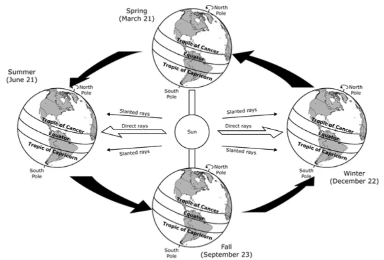
Based on the diagram, how does the Earth-Sun relationship affect the climate of different regions of the world?
It creates a pattern where different areas of the globe receive differing amounts of sunlight.
It creates a pattern in which the warm ocean currents bring monsoon rains to some regions.
It creates a pattern in which the summers and winters are longer than fall and spring seasons.
It creates a pattern where the eastern and western hemispheres have seasonal differences.
Which of the following is most directly responsible for the variation in seasonal weather patterns?
Phases of the Moon
Tilt of the Earth's axis
Distance from the Sun
Rotation of the Earth on its axis

The landforms listed in the box are created by the physical process of —
plate tectonics
wind erosion
weathering
soil-building
Which of the following best describes the physical process of erosion?
The wearing down of rocks by wind and water.
The breaking of the Earth’s crust that causes a fault.
The movement of weathered materials by wind, ice or water.
The mixing of weathered rock with decayed plant and animal material.
The process of erosion can best be described as the movement of weathered materials by —
tectonic forces
wind, water, or ice
human environment interaction
The world's oldest desert, the Namib Desert, has existed for at least 55 million years, and completely lacks surface water. This extremely arid region is made up of shifting sand dunes, gravel plains and rugged mountains. It is divided in half by several dry riverbeds. These riverbeds have some vegetation and are home to a few animals such as zebras, antelopes, and gazelles that can survive with little water. Humans have removed much of the vegetation that once existed in the already dry desert. The southern portion of the desert is extremely dry and even lacks dry riverbeds. The most important feature of the Namib Desert is its sparse and highly unpredictable annual rainfall. The annual average ranges from less than half an inch in the west to over three inches along its eastern limits. There is great variation in rainfall between years, with the driest areas of the desert having the highest variation.
The Namib Desert was formed due to —
climatic forces
tectonic forces
human habitation
overgrazing by animals
River deltas are found on the lower reaches of rivers, where the flow of water spreads out and slows down, depositing sediments into expanses of wetlands and shallow water. There are two types of deltas: coastal deltas where the river meets the sea and inland deltas where the river fills extensive floodplains and marshes. One of the most famous African examples of an inland delta is the Inner Niger Delta in Mali.
—Wetlands International website
Which physical environmental process is responsible for the creation of the types of landforms described in the excerpt?
Erosion
Droughts
Ocean currents
Tectonic plate movement
Which physical process is most responsible for the formation of islands in the Pacific Ocean?
Erosion
Landslides
Flood deposits
Tectonic activity
Which physical process contributes to the reduction in the size of islands in the Pacific Ocean over time?
Erosion
Glaciation
Volcanism
Deposition
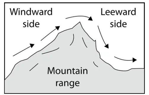
How would this barrier affect the climate on the leeward side?
The temperatures would be warm and the amount of precipitation low.
The temperatures would be warm and the amount of precipitation high.
The temperatures would be very cold and the amount of precipitation high.
The temperatures would be extremely cold and the amount of precipitation low.
Temperature ranges in areas near oceans usually —
vary widely because of the effects of storms
do not vary much because land heats and cools quickly
vary widely because some oceans are warmer than others
do not vary much because large bodies of water warm and cool slowly
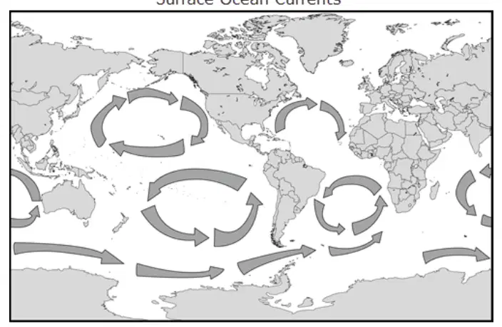
How do the patterns illustrated on the map influence climate?
By moderating extremes in temperature
By reducing wind speeds across continents
By shifting powerful storms away from land
By increasing precipitation at high elevations
The climate of an area is determined by the combination of precipitation and temperature. Which of the following most affects these two factors?
Latitude and longitude
Weathering and erosion
Convection and subduction
Proximity to water and latitude
Which of the following best explains how elevation influences temperature?
Higher elevations experience cooler temperatures compared to lower elevations.
Higher elevations experience warmer temperatures compared to lower elevations.
Higher elevations experience very little temperature variation from lower elevations.
Higher elevations experience varied temperatures depending on proximity to oceans.
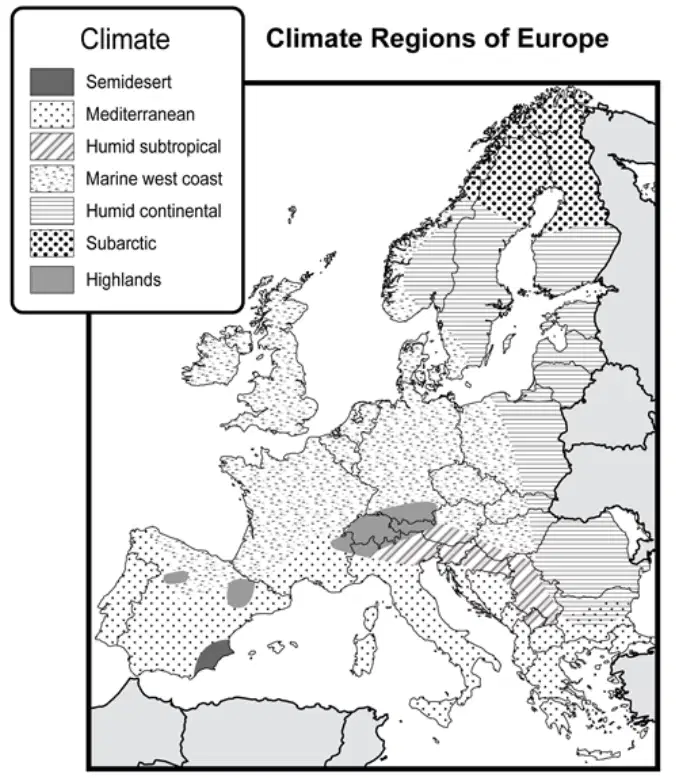
Which physical is most responsible for creating the climate pattern shown on the map?
Erosion
Deforestation
Wind currents
Mountain barriers
Areas of Europe affected by a Mediterranean climate most likely experience —
heavy rains
cold, snowy winters
warm, dry summers
short growing seasons
As a river reaches its mouth, it is often affected by incoming tides, resulting in a formation called a —
fjord
delta
plateau
canyon
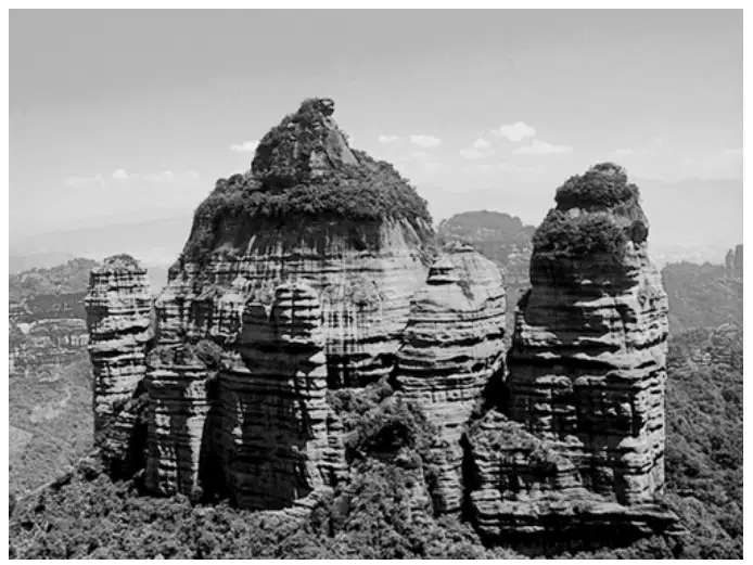
This unique landform of Southeast China is called danxia. The United Nations designated a series of these formations in 2010 as a World Heritage Site.
Which physical process is most likely responsible for this landform?
Erosion
Monsoons
Volcanic activity
Tectonic divergence
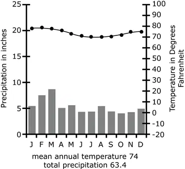
The biome reflected in the graph would be located in the —
highlands
high latitudes
middle latitudes
tropical latitudes
What type of climate is characteristic of temperate grassland biomes?
Low temperatures and low amounts of precipitation
High temperatures and large amounts of precipitation
Low temperatures at high altitudes and large amounts of precipitation
Seasonal shifts in temperature and variation in amounts of precipitation
How does a Geographic Information System (GIS) function as a resource for businesses or government officials?
A GIS generates several surveys used to gather data about geographic patterns.
A GIS presents data in visual forms making it easier to see geographic patterns.
A GIS creates a variety of predictions about geographic patterns for consumers.
A GIS produces reports about geographic decisions that have been made before.
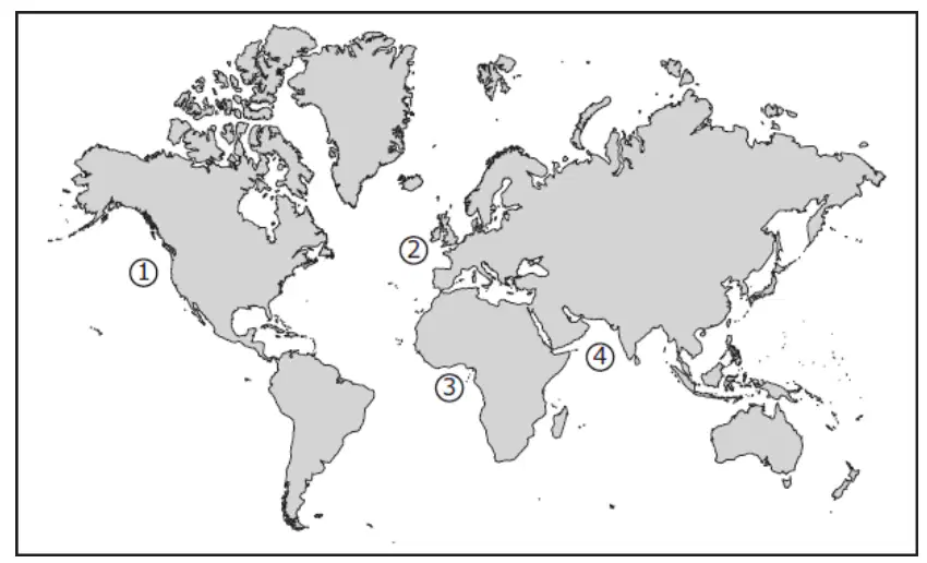
In which location did merchants historically use monsoon winds to travel along trade routes?
1
2
3
4
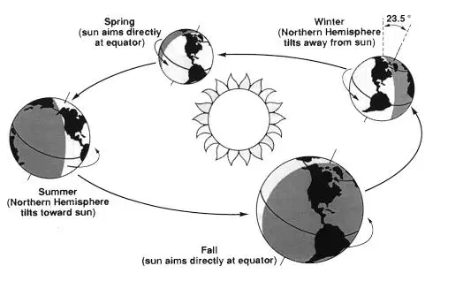
When the Northern Hemisphere is entering summer, the Southern Hemisphere is starting to feel the cold of winter. The sun’s glancing rays are spread over a greater surface area and must travel through more of the atmosphere before reaching the earth. There are also fewer hours of daylight in a 24-hour period. These seasonal differences are caused by —
the South Pole being tilted away from the sun
the South Pole being tilted toward the sun
the earth’s distance from the sun
the relationship of the moon to the sun
Which two factors have the greatest effect on climate?
Longitude and vegetation
Latitude and distance from water
Soil type and altitude
Mountain barriers and amount of arable land
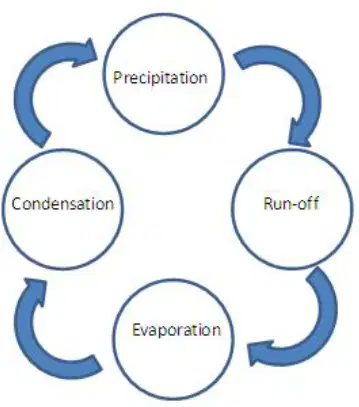
The graphic above describes an earth shaping process that occurs in which of the following?
Lithosphere
Hydrosphere
Biosphere
Atmosphere
Which of the following typically occurs in the biosphere?
Continuous circulation of hot and cold oceanic currents
Regulation of the rate at which thermal energy leaves the planet
The interaction of plants and animals within specific climate regions
The recycling of the continental crust in subduction zones
What would you expect to find when an oceanic plate converges with a continental plate?
folded mountain
subduction volcano
transform fault
Earth’s Arctic biome is located above 66°N latitude. Which statement best explains why low-growing plants in this biome thrive only in the spring and summer months?
Excessive levels of precipitation in early spring cause frequent floods in the biome.
The biome receives the greatest amount of solar energy during the spring and summer months.
The permafrost in the biome traps toxic levels of carbon dioxide during the winter months.
Year-round human activity disrupts the life cycles of native organisms in the biome.
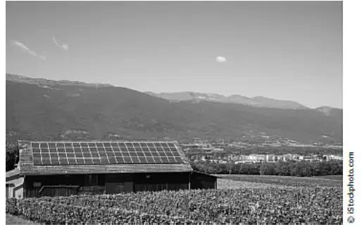
In which location would the environmental adaptation shown above most successfully serve its purpose?
A place with low elevation
A place that experiences regular monsoons
A place that experiences frequent sunny days
A place with high daily temperatures
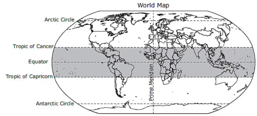
Which characteristic is common to all the countries located in the shaded region on this map?
A warm climate
Coniferous forests
The widespread practice of Hinduism
The use of a Romance language
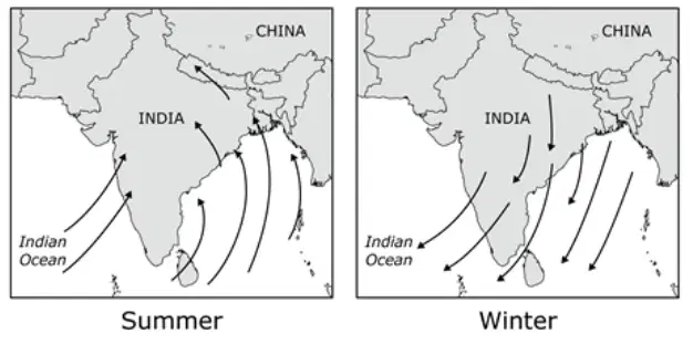
The physical process shown in the map would most likely result in —
a La Nina causing drought in the summer and flooding in the winter
typhoons that cause deforestation in both the summer and winter months
tsunamis that cause property damage in the summer, but not during the winter.
wide variation of heavy rains in the summer and warm, dry temperatures in the winter
One way farmers living in arid climate zones have adapted to the environment include —
cutting down the rainforests
relying on desalinization plants
planting drought-resistant crops
adopting terrace farming methods
As climate change becomes a more recognized global issue, many countries are starting to —
limit the production of vehicles that use alternative fuels
require the use of petroleum products
pass legislation mandating the reduction of carbon emissions
deregulate the coal industry
Identify the hotspot that is located on the continent of Europe.
Identify the hotspot that is located on the continent of Asia.
Identify the hotspot that is located on the continent of Australia.
Identify the hotspot that is located on the continent of Africa.
Approximately what percentage of Earth is covered by water?
30%
50%
70%
90%
What is the best definition of human geography?
the way that human activity affects Earth
the systems that define a place and a region
the role that governments play throughout history
the way that plants, animals, and humans interact
Which statement best describes how oceans regulate Earth’s climate?
Oceans provide life to various plants and animals.
Oceans make trade possible around the world.
Oceans absorb heat-producing chemicals that create pollution.
Oceans move heat from hotter regions to colder regions.
Which statement best describes the differences between weather and climate?
Weather changes every day based on conditions. Climate is long-term weather patterns in a region.
Weather just happens. Climate is man-made.
Weather determines what we see out the window. Climate determines how we dress in the morning.
Weather includes temperature, precipitation, and wind. Climate is a pattern.
Which of the following systems are studied by geography? Choose the two answers that apply.
historical systems
physical systems
biological systems
philosophical systems
What is the largest, most populous continent?
North America
South America
Africa
Asia
Which ocean lies between the United States and Europe?
Atlantic Ocean
Pacific Ocean
Indian Ocean
Arctic Ocean
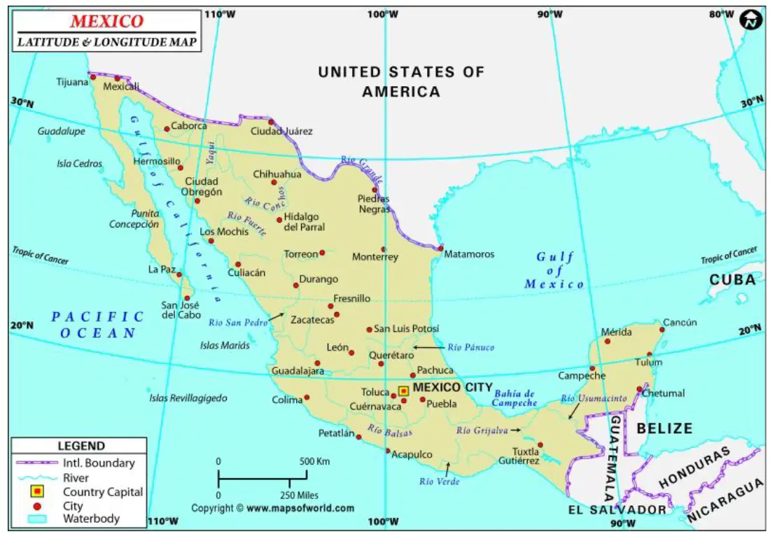
Refer to the map of Mexico. What is the longitude of Mexico City?
18°
22°
98°
102°
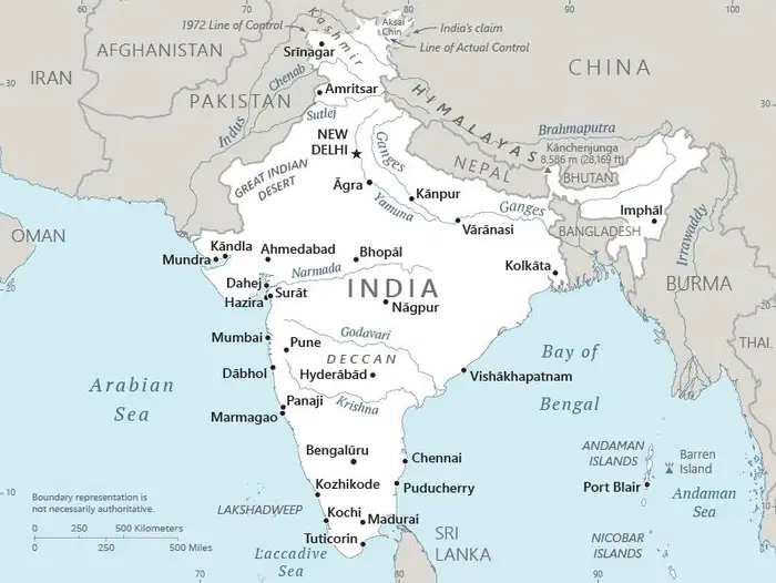
Which city is the capital of India?
Mumbai
Agra
Kolkata
New Delhi
Which statement best describes the main challenge of a growing population?
Humans have a hard time getting along with each other.
The world has a limited supply of resources.
People become sick with the same illnesses.
Some regions of the world grow too much food.
Suppose you’re looking at a topographic map. How can you tell it’s a topographic map rather than a physical map?
It is drawn more precisely to scale than a physical map.
It includes latitude and longitude but not place names.
It uses lines, not colors, to show how the land changes.
It was created and updated by the U.S. government.
What information does a topographic map provide?
the climate of a region
the height of the land
the population of a place
the travel time to a destination
Why does every map projection contain some distortion?
Different people interpret the same projection in different ways.
Most map projections were invented years ago, before GIS existed.
The amount of information mapmakers have is limited by technology.
It's impossible to map exactly a three-dimensional object onto a flat surface.
On a thematic map, such as a population map or a map of airplane routes, why are natural features such as rivers and political features such as national borders included?
to make the map useful to more people
to indicate what the theme is
to help compare several maps
to provide reference points

