
 Worksheets
Map Skills Test
Total questions: 32
Worksheet time: 16mins
Name
Class
Date
1.
Last Name
4 lines
2.
First Name
4 lines
3.
You can find landforms on a __________ map.
a)
political
b)
physical
c)
thematic
d)
Mercator
4.
The imaginary line that divides the north and south hemispheres is the __________.
a)
Equator
b)
Prime Meridian
c)
International Date Line
d)
Tropic of Cancer
5.
One half of the globe is called a _________.
a)
Arctic Circle
b)
Antarctic Circle
c)
hemisphere
d)
compass
6.
The __________ divides the earth into east and west hemispheres.
a)
Tropic of Capricorn
b)
International Date Line
c)
Equator
d)
Prime Meridian
7.
Impacts the climate of an area (ex: Gulf Stream near Great Britain)
a)
Map Scale
b)
Ocean Currents
c)
Elevation
d)
Latitude
e)
Longitude
8.
Location east or west of the Prime Meridian
a)
Map Scale
b)
Ocean Currents
c)
Elevation
d)
Latitude
e)
Longitude
9.
On a map, used to measure distance that represents length on the ground
a)
Map Scale
b)
Ocean Currents
c)
Elevation
d)
Latitude
e)
Longitude
10.
The height of land above sea level
a)
Map Scale
b)
Ocean Currents
c)
Elevation
d)
Latitude
e)
Longitude
11.
Location north or south of the Equator
a)
Map Scale
b)
Ocean Currents
c)
Elevation
d)
Latitude
e)
Longitude
12.
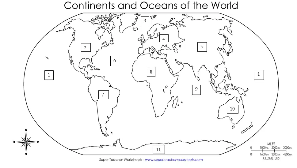
Africa
a)
8
b)
1
c)
2
d)
3
e)
4
13.
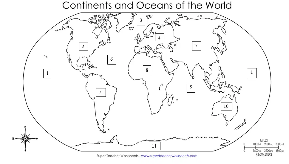
Antarctica
a)
11
b)
1
c)
2
d)
3
e)
4
14.
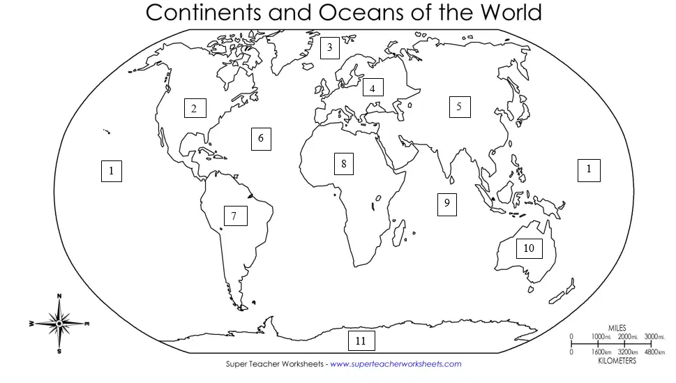
Arctic Ocean
a)
3
b)
1
c)
2
d)
4
e)
5
15.
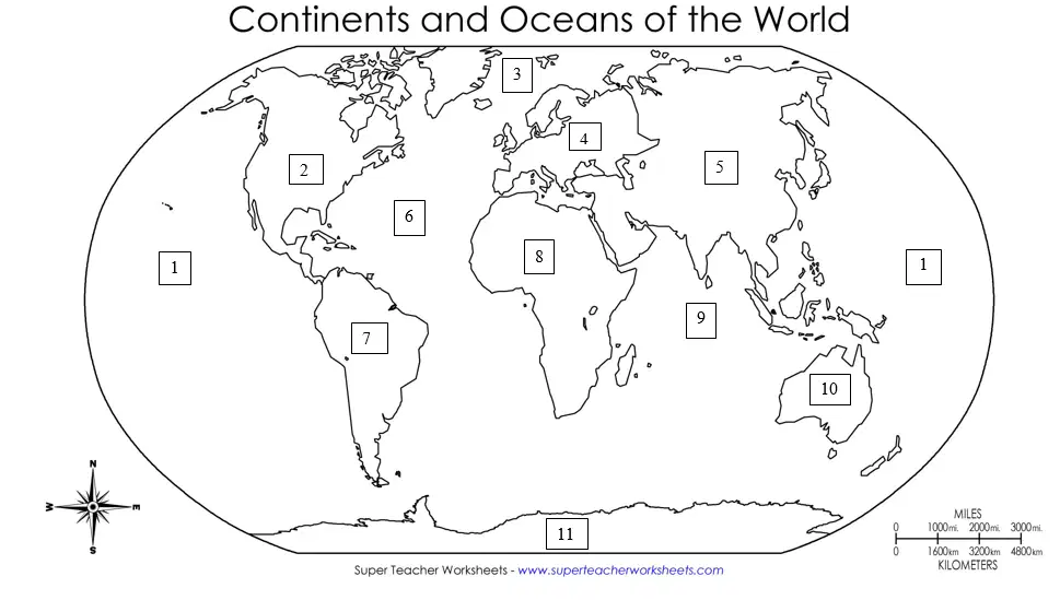
Asia
a)
5
b)
1
c)
2
d)
3
e)
4
16.

Atlantic Ocean
a)
6
b)
1
c)
2
d)
3
e)
4
17.
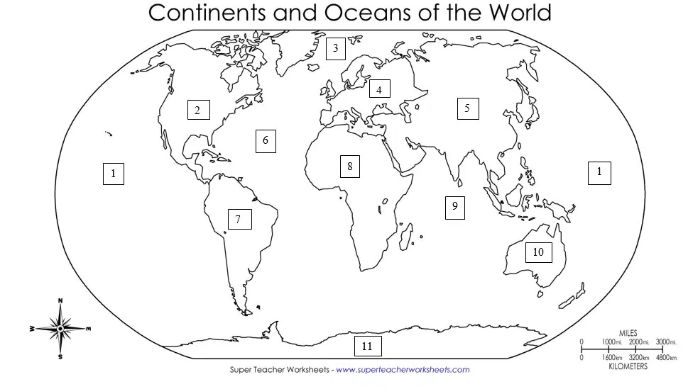
Australia
a)
10
b)
1
c)
2
d)
3
e)
4
18.
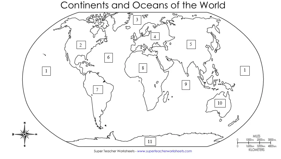
Europe
a)
4
b)
1
c)
2
d)
3
e)
5
19.
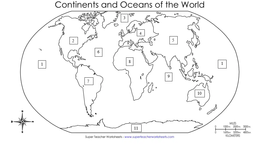
Indian Ocean
a)
9
b)
1
c)
2
d)
3
e)
4
20.
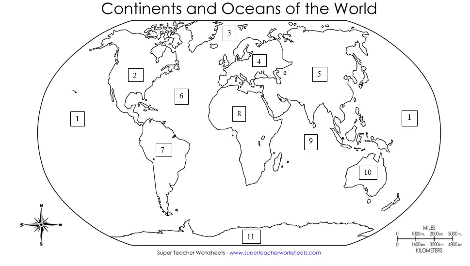
North America
a)
2
b)
1
c)
3
d)
4
e)
5
21.

Pacific Ocean
a)
1
b)
2
c)
3
d)
4
e)
5
22.

South America
a)
7
b)
1
c)
2
d)
3
e)
4
23.

Maputo, Mozambique: 26°S, 30°E
a)
J
b)
A
c)
B
d)
C
e)
D
24.

Casablanca, Morocco: 28°N, 10°W
a)
F
b)
A
c)
B
d)
C
e)
D
25.
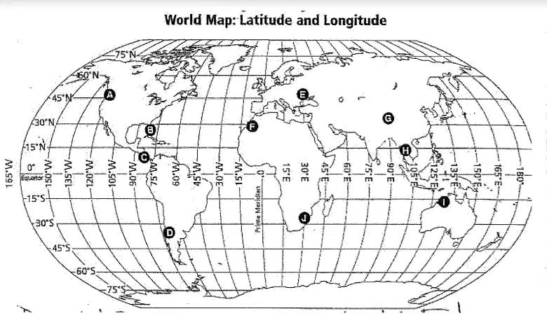
Wyndham, Australia: 16°S, 128°E
a)
I
b)
A
c)
B
d)
C
e)
D
26.
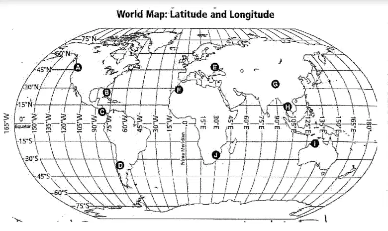
Bangkok, Thailand: 14°N, 101°E
a)
H
b)
A
c)
B
d)
C
e)
D
27.
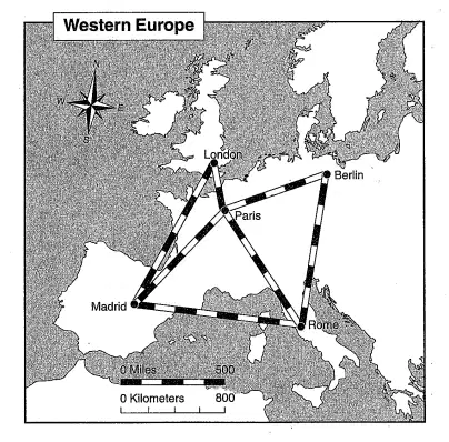
Using the map of Western Europe below, how far would you travel to get to Berlin from Rome?
a)
approximately 700 kilometers
b)
approximately 700 miles
c)
approximately 800 miles
d)
approximately 500 kilometers
e)
approximately 500 miles
28.
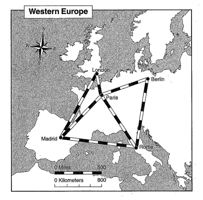
Using the map of Western Europe below, which direction would you travel to get to Berlin from Rome?
a)
North
b)
Northeast
c)
East
d)
Southeast
e)
South
29.
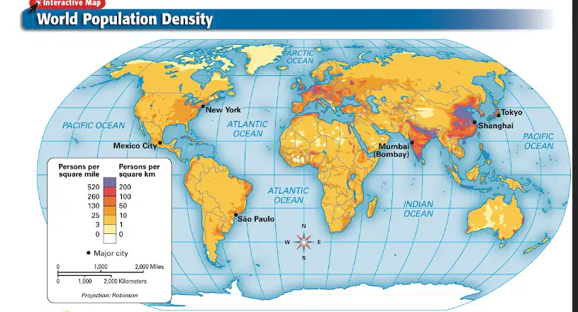
According to the population density map below, which continent has areas with the highest population densities?
a)
Asia
b)
Africa
c)
Antarctica
d)
Australia
e)
Europe
30.
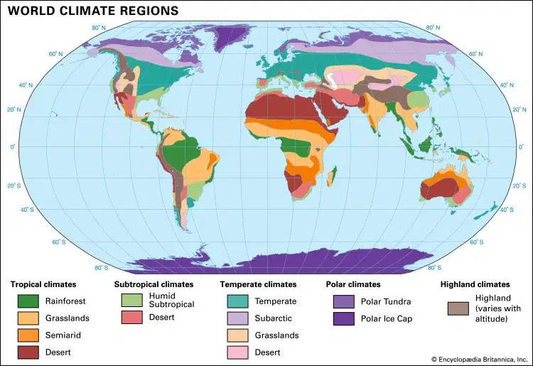
According to the climate map below, what can you infer about northern Africa?
a)
Northern Africa is dry/has little precipitation.
b)
Northern Africa has some of the highest elevations in the world.
c)
Northern Africa's climate is great for growing things.
d)
Northern Africa is cold all year long.
e)
All of the above
31.

According to the elevation map below, what can you infer about the southeastern United States?
a)
The southeastern U.S. has little to no mountains.
b)
The southeastern U.S. has some of the highest elevations in the country.
c)
The Rocky Mountains are located in the southeastern U.S.
d)
Hawaii is flatter than the southeastern U.S.
e)
All of the above
32.

According to the ocean currents map below, which of the following is true regarding South America?
a)
The Brazil Current warms the eastern coast of South America.
b)
The Agulhas Current warms the eastern coast of South America.
c)
The Brazil Current warms the western coast of South America.
d)
The Peru Current cools the eastern coast of South America.
e)
All of the above
100 %

