
NEW
Font size
 Worksheets
Foundations of History Part 1
Total questions: 25
Worksheet time: 13mins
Based on the provided notes in CANVAS, what is the best definition of history?
The study of major global events like wars and revolutions.
The study of past events supported by evidence.
The study of what people think happened in the past.
The collection of stories passed down from generation to generation.
A historian is described as being like a detective. Why is this a good comparison?
Historians only study crimes from the past.
They create stories about the past from their imagination.
They track down clues and analyze cause-and-effect relationships from collected information and records.
Their main job is to prevent people from making mistakes in the future.
What is a key difference between weather and climate?
Weather is what you expect, while climate is what you get.
Weather is based on a specific location, while climate is not.
Weather changes over a long period, while climate changes quickly.
Weather describes day-to-day conditions, while climate describes average weather patterns over a long period.
Why are time zones necessary, according to the notes?
To allow businesses to have longer operating hours.
To keep all clocks around the world on the exact same time.
To ensure that 'daytime' hours on a clock match when the sun is out in a specific location.
To allow different countries to have their own unique time.
According to the notes, which imaginary line separates the Earth into the Eastern and Western Hemispheres?
The Equator
The Tropic of Cancer
The International Date Line
The Prime Meridian
The notes mention that the Earth's tilt is the most important factor in causing the seasons. How does this tilt cause the seasons?
The tilt changes the speed of the Earth's rotation, making days longer or shorter.
It causes different parts of the Earth to be closer or farther from the sun at different times of the year.
It makes the Earth move in a different orbit around the sun each year.
It causes different parts of the Earth to receive more direct sunlight at different times of the year.
Why is the Tropical Zone generally warm and wet all year?
It is located at the poles, where ice melts to create a wet climate.
It is found between the Tropics of Cancer and Capricorn, where the sun's rays hit almost directly.
It is in the Temperate Zones, which have four distinct seasons.
It is a region that experiences very long, dark winters.
What is the primary purpose of a compass, according to the notes?
To tell time.
To measure temperature.
To find direction and help with navigation.
To predict the weather.
The notes state that the compass was first used in China for geomancy (like Feng Shui). How does this differ from its later use for maritime navigation?
The compass was used for spiritual and alignment purposes before its use for practical sea travel.
Early compasses did not have a magnetic needle.
It was used for navigation in the sea, which is an ancient practice, whereas geomancy is a modern one.
The compass was not invented in China, so this is an incorrect statement.
According to the notes, what are the two main ways to divide the Earth into hemispheres?
By climate zones and continents.
By latitude and longitude.
By the Equator (Northern and Southern) and the Prime Meridian (Eastern and Western).
By the Tropic of Cancer and the Tropic of Capricorn.
Lines of latitude and longitude are used to determine a location’s 'absolute location.' What does this mean?
The location of a place relative to another landmark.
A location's address or street name.
The exact location on Earth's surface using a grid system.
The fastest route to get to a location.
According to the notes, what is the significance of the Tropic of Capricorn?
It is the northernmost point where the sun's rays are directly overhead at noon.
It is the line that separates the Northern and Southern Hemispheres.
It is the southernmost point where the sun's rays can be directly overhead at noon.
It marks the boundary of the Arctic zone.
A timeline is a way to organize events. What are some of the common units of time used in a timeline, according to the notes?
Hours, minutes, and seconds.
Years, decades, centuries, and millennia.
Weather, climate, and seasons.
Hemispheres, meridians, and parallels.
What is the main difference between the BC and AD dating systems?
AD refers to dates that occurred before the birth of Jesus, while BC refers to dates after his birth.
BC stands for "Before Christ" and counts backwards from the year 1, while AD stands for "Anno Domini" and counts forward.
BC is a term used for the modern era, while AD is a term used for ancient history.
The BC and AD systems are only used for religious texts and not for historical events.
Which of the following scientific disciplines helps us understand 'when' an event happened, according to the notes?
Geography
Archaeology
Chronology
History
According to the notes, which of the following is the primary purpose of a physical map?
To show political boundaries and city locations.
To show landforms, bodies of water, and elevation.
To show the location of major roads and highways.
To show the population density of different areas.
According to the notes, what happens when two tectonic plates carrying land crash together?
Hot, melted rock (magma) bubbles up and creates new land.
They slowly grind past each other, which causes an earthquake.
The plates push and fold the land upwards, forming giant mountains.
One plate slides underneath the other, creating deep ocean trenches.
According to the notes, what is a key disadvantage of a flat map compared to a globe?
A flat map cannot show oceans and continents on Earth's curved surface
A flat map cannot show the true shapes and locations of Earth's landforms.
A flat map can only be drawn to a specific size, while a globe can be any size.
A flat map is a less accurate representation of Earth's surface because it is distorted when flattened.
Which of the following is NOT a way that valleys are formed, as described in the notes?
When plates pull apart and a strip of land sinks down.
When tectonic plates slide past each other.
When rivers carve into the land as they flow downhill.
When glaciers dig out the land as they move.
According to the notes, what is the initial force that causes rivers to flow and wear away the land?
The pressure of water building up in the mountains.
The slow movement of tectonic plates.
The erosion caused by chemical reactions in the water.
Gravity pulling the water downhill.
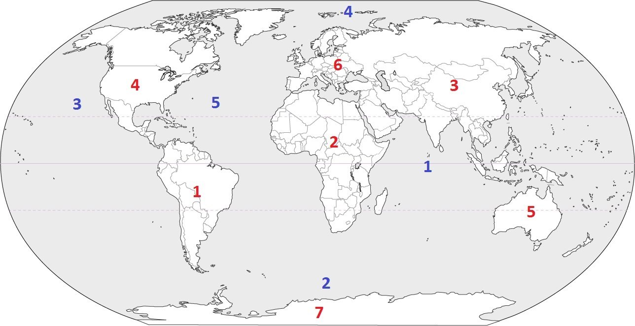
Identify the ocean at location #1
Southern Ocean
Arctic Ocean
Atlantic Ocean
Indian Ocean
Which imaginary line is used as the starting point for measuring time zones around the world?
The Tropic of Cancer
The Prime Meridian
The International Date Line
The Equator
Which planet in our solar system is known for its prominent rings?
Venus
Mars
Saturn
Jupiter
Which of the following best explains why there is a time difference between California and New York?
California observes daylight saving time, but New York does not.
New York is closer to the Equator than California.
They are located in different time zones due to Earth's rotation.
They are in different hemispheres.
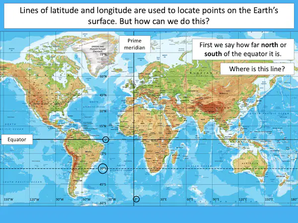
If a location has coordinates 40°N, 74°W, which city is it most likely referring to?
Sydney
Tokyo
New York City
London

