
 Worksheets
U.S. & Canada Unit Test
Total questions: 68
Worksheet time: 34mins
Name
Class
Date
1.
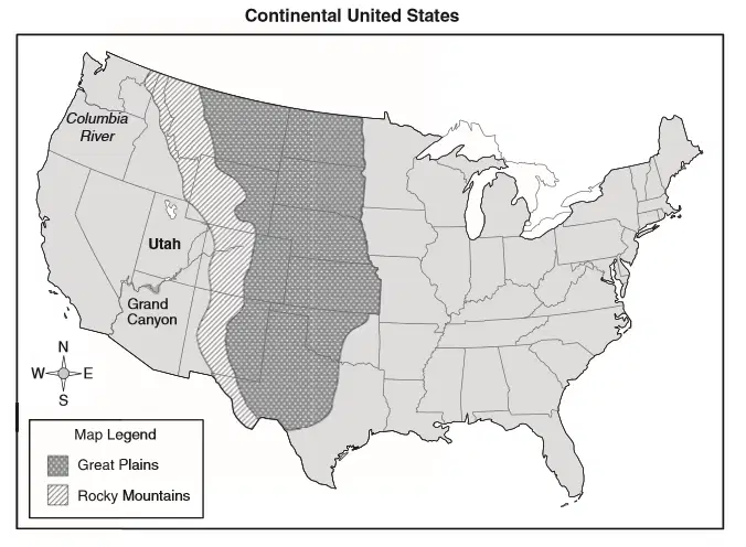
Using a physical characteristic as a reference point, Utah is located -
a)
east of the Great Plains.
b)
south of the Grand Canyon.
c)
north of the Columbia River.
d)
west of the Rocky Mountains.
2.
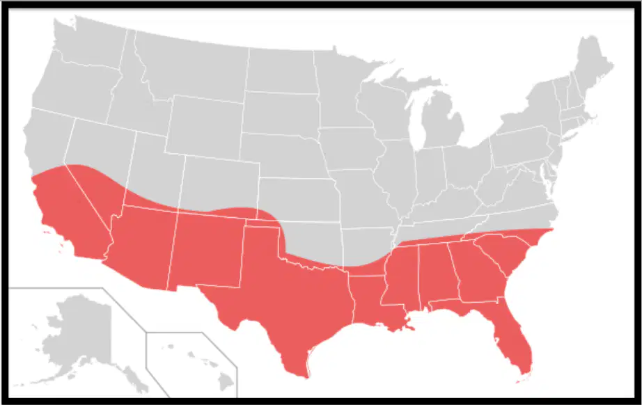
Which region is highlighted on this map?
a)
Rust Belt
b)
Corn Belt
c)
Sun Belt
d)
Wheat Belt
3.
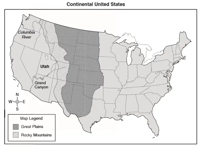
Using a physical characteristic as a reference point, Utah is located -
a)
east of the Great Plains.
b)
south of the Grand Canyon.
c)
north of the Columbia River.
d)
west of the Rocky Mountains.
4.
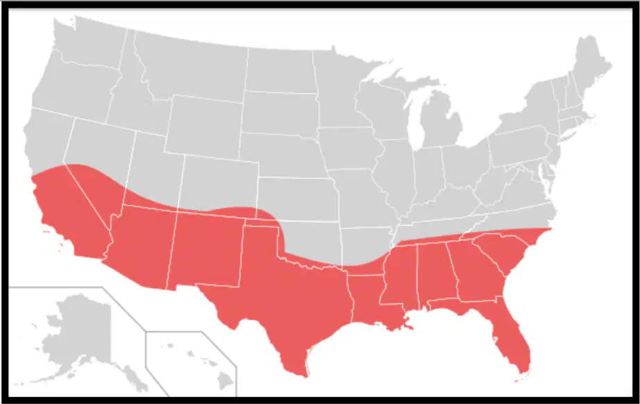
Which region is highlighted on this map?
a)
Rust Belt
b)
Corn Belt
c)
Sun Belt
d)
Wheat Belt
5.
Which mountain range is shared between Canada and the United States?
a)
Ural Mountains
b)
Alps
c)
Rocky Mountains
d)
Andes Mountains
6.
What river creates a border between the United States and Mexico?
a)
Columbia
b)
St. Lawrence
c)
Rio de la Plata
d)
Rio Grande
7.
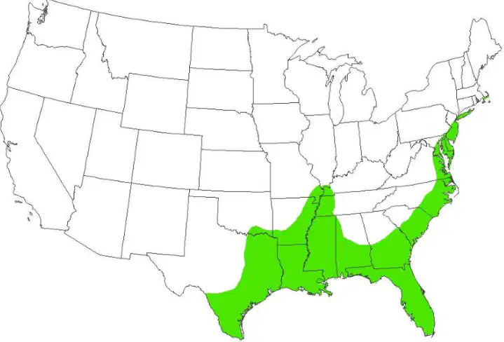
What region is represented on the map?
a)
Interior Lowlands
b)
Atlantic Coastal Shield
c)
Great Plains
d)
Atlantic and Gulf Coastal Plains
8.
Which mountain range flanks the eastern coast of North America?
a)
Alps
b)
Appalachians
c)
Andes
d)
Atlas
9.
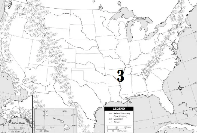
What river is represented by the number 3 on the map?
a)
Rio Grande
b)
Mississippi
c)
Colorado
d)
Columbia
10.
The United States and Canada have few resources.
a)
True
b)
False
11.
Which region of the United States and Canada would most likely experience seismic activity like earthquakes and volcanic eruptions?
a)
West Coast
b)
Great Plains
c)
Sun Belt
d)
Mississippi River Valley
12.
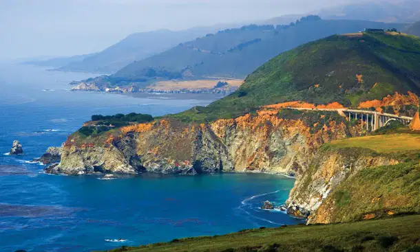
Coast Range escarpments drop off into what ocean coastline?
a)
Atlantic
b)
Pacific
c)
Arctic
d)
Indian
13.
Which statement is the most accurate assessment of the effect of multiculturalism in Quebec, Canada?
a)
Racial diversity has made Quebec a major destination of immigrants.
b)
The quality of its universities has made Quebec attractive to technology corporations.
c)
Cultural differences have weakened Canada's political ties to the United States.
d)
The diversity of languages has strengthened Canada's cultural ties to Europe.
14.
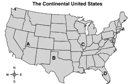
The Rocky Mountains are located nearest to which point on the map?
a)
A
b)
B
c)
C
d)
D
15.
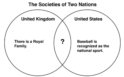
Which fact correctly completes the diagram?
a)
A major holiday is Independence Day.
b)
English is the main language spoken.
c)
Representatives are elected to Congress.
d)
The city with the highest population is the national capital.
16.
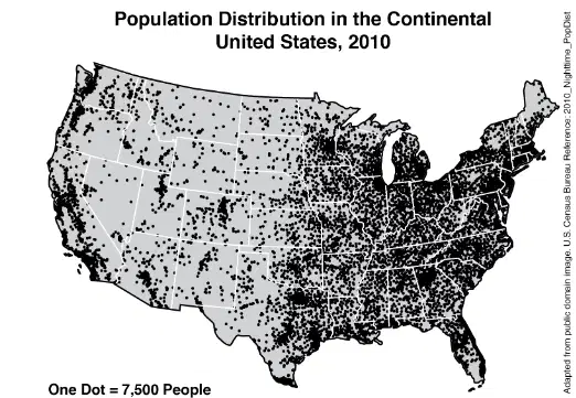
Based on the map, which group of states has the highest combined population density?
a)
Colorado, Utah, Nevada
b)
New Mexico, Arizona, Oklahoma
c)
Massachusetts, Connecticut, New York
d)
North Dakota, South Dakota, Minnesota
17.
Which of these was created by volcanic eruption?
a)
Great Lakes
b)
Grand Canyon
c)
Hawaiian Islands
d)
Monument Valley
18.
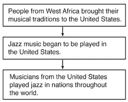
The process shown in the diagram is an example of how people-
a)
share ideas
b)
produce inventions
c)
migrate to find work
d)
practice religious traditions
19.
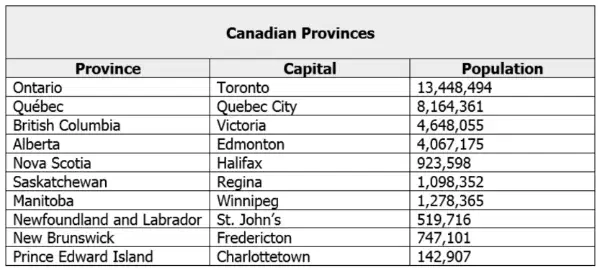
Use the chart to identify the least populated province in Canada.
a)
Ontario
b)
Nova Scotia
c)
Prince Edward Island
d)
Alberta
20.
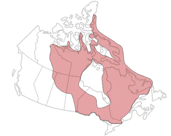
The area on the map shaded in red is called the-
a)
Great Plains
b)
Coastal Plains
c)
Rocky Mountains
d)
Canadian Shield
21.
Free trade zones like the one created by NAFTA are examples of what?
a)
Attempts by participating countries to limit trade by creating artificial barriers
b)
Attempts by participating countries to reduce illegal immigration
c)
Attempts by participating countries to implement mercantilist policies
d)
Attempts to break down artificial barriers like tariffs and increase trade
22.
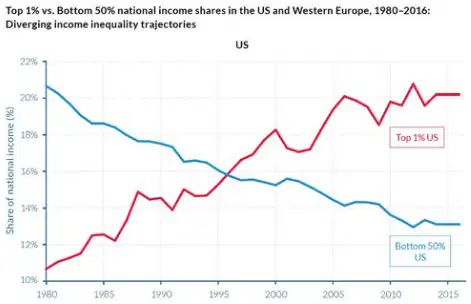
Which economic aspect of the U.S. Economy is represented by the graph below?
a)
The United States has a rich supply of mineral resources.
b)
The United States has a highly developed transportation infrastructure.
c)
The United States has experienced sustained economic growth.
d)
The United States has a growing gap between the rich and poor.
23.
How has climate affected where Canadians live?
a)
Few people live in the northern regions of Canada because of the cold climate.
b)
Few people live along the border of Canada and the U.S. because of the cold climate.
c)
Most people tend to migrate and live in the northern provinces of Canada.
d)
Most people tend to migrate toward Great Bear Lake and Great Slave Lake.
24.
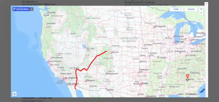
What river is highlighted red?
a)
Columbia
b)
Ohio
c)
Colorado
d)
Rio Grande
25.
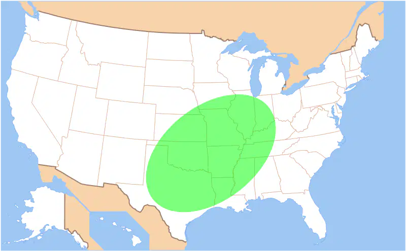
What natural hazard would most likely occur in the location highlighted on this map?
a)
earthquake
b)
volcanic eruption
c)
blizzard
d)
tornado
26.
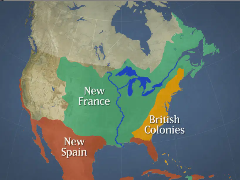
The United States and Canada were colonized by -
a)
Asia
b)
Africa
c)
South America
d)
Europe
27.
Which of the following is NOT a cultural characteristic of the United States and Canada?
a)
Highly urbanized
b)
Weak infrastructure
c)
High literacy rates
d)
Multicultural societies
28.
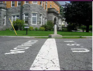
Which of the following do the United States and Canada have in common?
a)
Similar climates
b)
The first American populations
c)
The world's longest unfortified border
d)
The same governing body
29.
What city serves as the national capital of Canada?
a)
Toronto
b)
Vancouver
c)
Quebec
d)
Ottawa
30.
Which of the following statements best describes the city of Pittsburgh?
a)
a mega city on a harbor site that is a center for world trade and home to the world's largest stock exchange
b)
a major city on a confluence site that has transitioned from the steel industry to various services
c)
a major city situated on the Transcontinental Railroad that has about 140 trains pass through it every day
d)
a state capital on a fall line site of the James River
31.

Which statement below best explains how the image connects to the U.S. economy?
a)
The United States has a developing economy that is in the process of industrializing.
b)
The United States has a command economy that is focused on assuring equality of wealth for all citizens.
c)
Multinational Corporations have thrived under the United States' free market economy.
d)
Chinese companies like Shell and Coca-Cola are able to produce and market their products in the United States.
32.
The United States and Canada are both members of which of the following military alliances?
a)
NAFTA
b)
Warsaw Pact
c)
OPEC
d)
NATO
33.
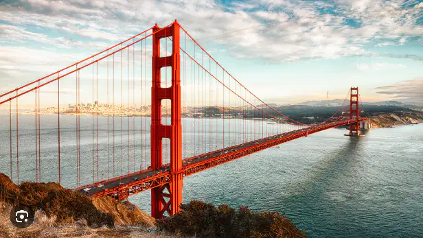
Which of the following best describes the cultural landmark in the image?
a)
The Tower Bridge in London
b)
The New River Gorge Bridge in Fayetteville, West Virginia
c)
The Golden Gate Bridge in San Francisco, California
d)
The Brooklyn Bridge in New York City
34.
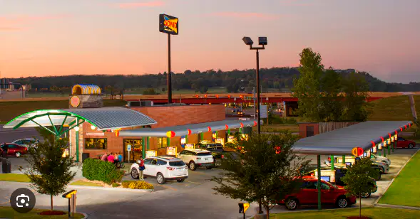
How does the image below connect to the cultural landscape of the United States?
a)
The United States is a multicultural society where diverse ethnic restaurants are common.
b)
The United States has a consumer culture where shopping malls are a common part of the cultural landscape.
c)
In the Great Plains, wheat fields are a common part of the cultural landscape and represent an industrialized agricultural system.
d)
The influence of the automobile has led to numerous types of drive up services in the United States.
35.
Which image below represents westward expansion and the idea of Manifest Destiny?
a)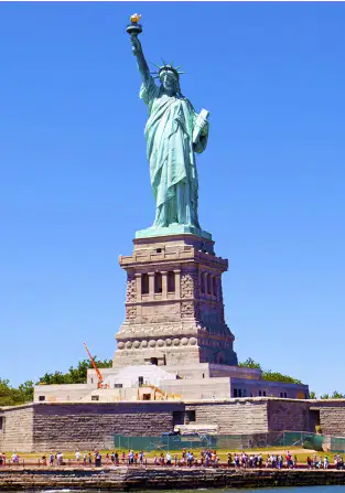
Option 1
b)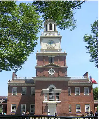
Option 2
c)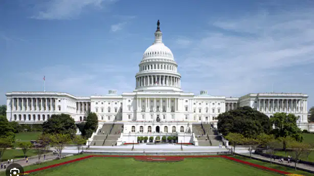
Option 3
d)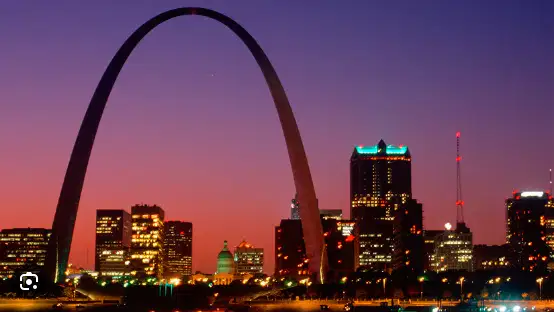
Option 4
36.
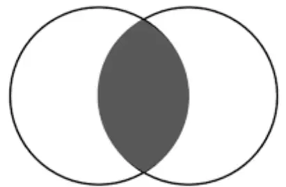
If the two circles below represent the United States and Canada, which of the items below would NOT belong in the shaded section of the diagram?
a)
Democratic forms of government
b)
Low literacy rates
c)
Diverse populations
d)
High standards of living
37.
Which mountain range is shared between Canada and the United States?
a)
Ural Mountains
b)
Alps
c)
Rocky Mountains
d)
Andes Mountains
38.
What river creates a border between the United States and Mexico?
a)
Columbia
b)
St. Lawrence
c)
Rio de la Plata
d)
Rio Grande
39.
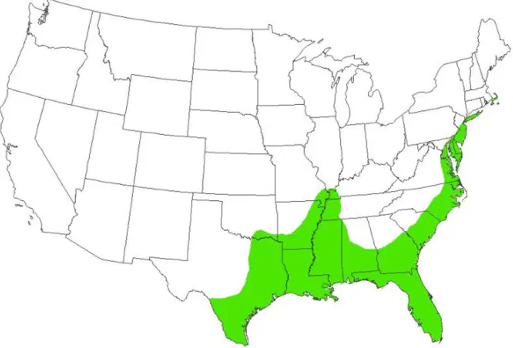
What region is represented on the map?
a)
Interior Lowlands
b)
Atlantic Coastal Shield
c)
Great Plains
d)
Atlantic and Gulf Coastal Plains
40.
Which mountain range flanks the eastern coast of North America?
a)
Alps
b)
Appalachians
c)
Andes
d)
Atlas
41.
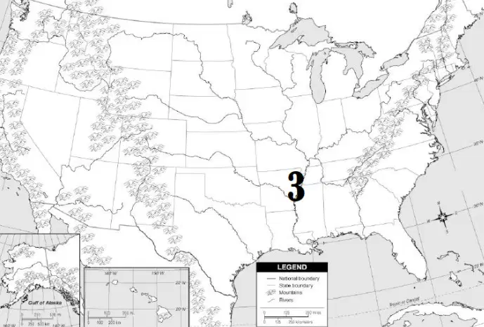
What river is represented by the number 3 on the map?
a)
Rio Grande
b)
Mississippi
c)
Colorado
d)
Columbia
42.
The United States and Canada have few resources.
a)
True
b)
False
43.
Which region of the United States and Canada would most likely experience seismic activity like earthquakes and volcanic eruptions?
a)
West Coast
b)
Great Plains
c)
Sun Belt
d)
Mississippi River Valley
44.
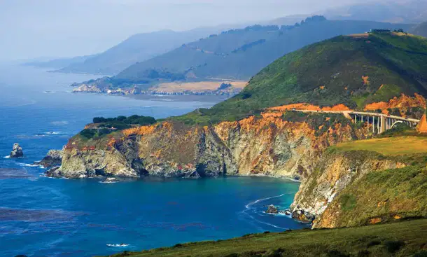
Coast Range escarpments drop off into what ocean coastline?
a)
Atlantic
b)
Pacific
c)
Arctic
d)
Indian
45.
Which statement is the most accurate assessment of the effect of multiculturalism in Quebec, Canada?
a)
Racial diversity has made Quebec a major destination of immigrants.
b)
The quality of its universities has made Quebec attractive to technology corporations.
c)
Cultural differences have weakened Canada's political ties to the United States.
d)
The diversity of languages has strengthened Canada's cultural ties to Europe.
46.
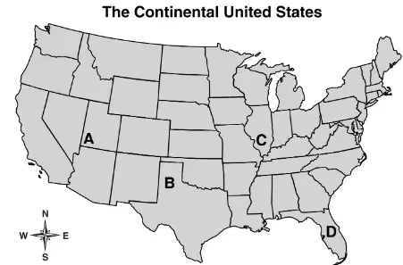
The Rocky Mountains are located nearest to which point on the map?
a)
A
b)
B
c)
C
d)
D
47.
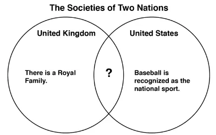
Which fact correctly completes the diagram?
a)
A major holiday is Independence Day.
b)
English is the main language spoken.
c)
Representatives are elected to Congress.
d)
The city with the highest population is the national capital.
48.
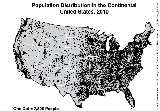
Based on the map, which group of states has the highest combined population density?
a)
Colorado, Utah, Nevada
b)
New Mexico, Arizona, Oklahoma
c)
Massachusetts, Connecticut, New York
d)
North Dakota, South Dakota, Minnesota
49.
Which of these was created by volcanic eruption?
a)
Great Lakes
b)
Grand Canyon
c)
Hawaiian Islands
d)
Monument Valley
50.
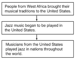
The process shown in the diagram is an example of how people-
a)
share ideas
b)
produce inventions
c)
migrate to find work
d)
practice religious traditions
51.
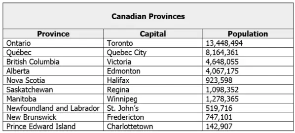
Use the chart to identify the least populated province in Canada.
a)
Ontario
b)
Nova Scotia
c)
Prince Edward Island
d)
Alberta
52.
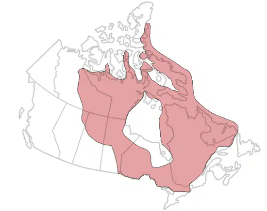
The area on the map shaded in red is called the-
a)
Great Plains
b)
Coastal Plains
c)
Rocky Mountains
d)
Canadian Shield
53.
Free trade zones like the one created by NAFTA are examples of what?
a)
Attempts by participating countries to limit trade by creating artificial barriers
b)
Attempts by participating countries to reduce illegal immigration
c)
Attempts by participating countries to implement mercantilist policies
d)
Attempts to break down artificial barriers like tariffs and increase trade
54.
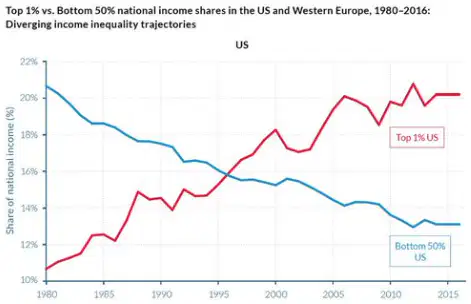
Which economic aspect of the U.S. Economy is represented by the graph below?
a)
The United States has a rich supply of mineral resources.
b)
The United States has a highly developed transportation infrastructure.
c)
The United States has experienced sustained economic growth.
d)
The United States has a growing gap between the rich and poor.
55.
How has climate affected where Canadians live?
a)
Few people live in the northern regions of Canada because of the cold climate.
b)
Few people live along the border of Canada and the U.S. because of the cold climate.
c)
Most people tend to migrate and live in the northern provinces of Canada.
d)
Most people tend to migrate toward Great Bear Lake and Great Slave Lake.
56.
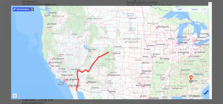
What river is highlighted red?
a)
Columbia
b)
Ohio
c)
Colorado
d)
Rio Grande
57.
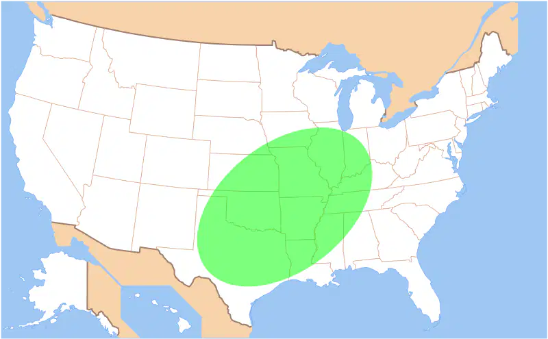
What natural hazard would most likely occur in the location highlighted on this map?
a)
earthquake
b)
volcanic eruption
c)
blizzard
d)
tornado
58.

The United States and Canada were colonized by -
a)
Asia
b)
Africa
c)
South America
d)
Europe
59.
Which of the following is NOT a cultural characteristic of the United States and Canada?
a)
Highly urbanized
b)
Weak infrastructure
c)
High literacy rates
d)
Multicultural societies
60.
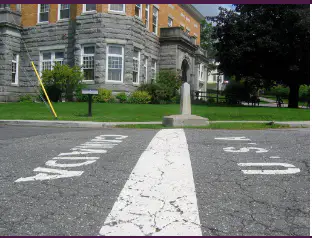
Which of the following do the United States and Canada have in common?
a)
Similar climates
b)
The first American populations
c)
The world's longest unfortified border
d)
The same governing body
61.
What city serves as the national capital of Canada?
a)
Toronto
b)
Vancouver
c)
Quebec
d)
Ottawa
62.
Which of the following statements best describes the city of Pittsburgh?
a)
a mega city on a harbor site that is a center for world trade and home to the world's largest stock exchange
b)
a major city on a confluence site that has transitioned from the steel industry to various services
c)
a major city situated on the Transcontinental Railroad that has about 140 trains pass through it every day
d)
a state capital on a fall line site of the James River
63.

Which statement below best explains how the image connects to the U.S. economy?
a)
The United States has a developing economy that is in the process of industrializing.
b)
The United States has a command economy that is focused on assuring equality of wealth for all citizens.
c)
Multinational Corporations have thrived under the United States' free market economy.
d)
Chinese companies like Shell and Coca-Cola are able to produce and market their products in the United States.
64.
The United States and Canada are both members of which of the following military alliances?
a)
NAFTA
b)
Warsaw Pact
c)
OPEC
d)
NATO
65.
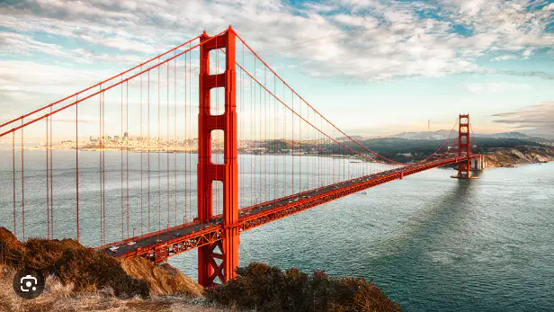
Which of the following best describes the cultural landmark in the image?
a)
The Tower Bridge in London
b)
The New River Gorge Bridge in Fayetteville, West Virginia
c)
The Golden Gate Bridge in San Francisco, California
d)
The Brooklyn Bridge in New York City
66.
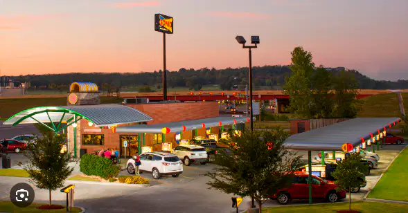
How does the image below connect to the cultural landscape of the United States?
a)
The United States is a multicultural society where diverse ethnic restaurants are common.
b)
The United States has a consumer culture where shopping malls are a common part of the cultural landscape.
c)
In the Great Plains, wheat fields are a common part of the cultural landscape and represent an industrialized agricultural system.
d)
The influence of the automobile has led to numerous types of drive up services in the United States.
67.
Which image below represents westward expansion and the idea of Manifest Destiny?
a)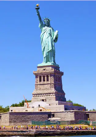
Option 1
b)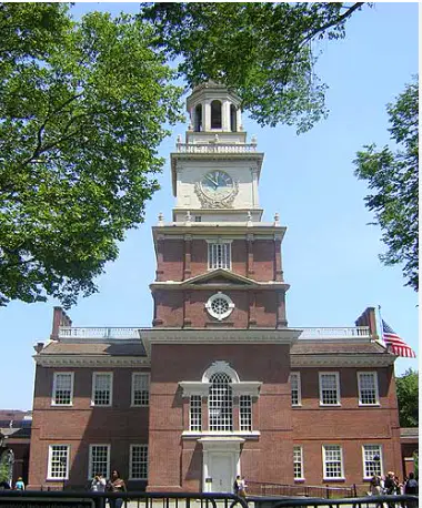
Option 2
c)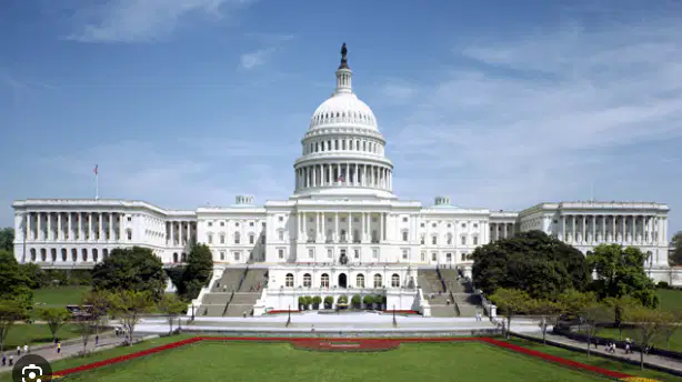
Option 3
d)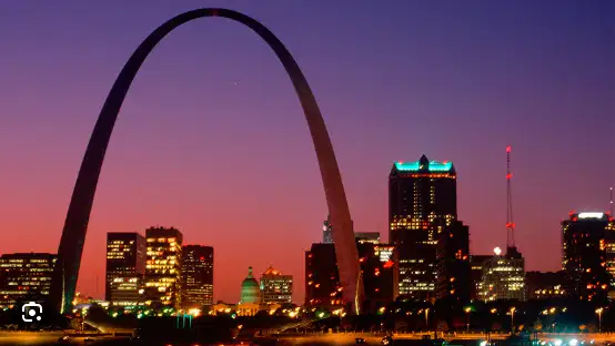
Option 4
68.
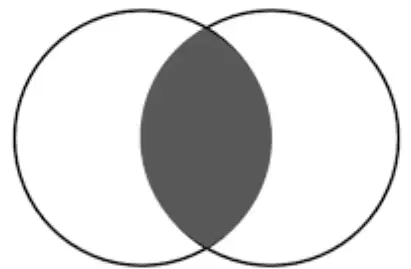
If the two circles below represent the United States and Canada, which of the items below would NOT belong in the shaded section of the diagram?
a)
Democratic forms of government
b)
Low literacy rates
c)
Diverse populations
d)
High standards of living
100 %

