
 Worksheets
1 replication SWCE
Total questions: 55
Worksheet time: 29mins
What does "Moisture equivalent" refer to in soil science?
The amount of water retained by a sample of initially saturated soil material
The range in soil moisture content where plants undergo wilting
The soil moisture between field capacity and permanent wilting point
The maximum water-holding capacity of soil
What is the "Wilting Range" in soil moisture content?
The amount of water retained by a saturated soil sample
The range in soil moisture content where plants undergo progressive permanent or irreversible wilting
The soil moisture between field capacity and permanent wilting point
The water content at field capacity
What does "Available Water" in soil refer to?
The water content at field capacity
The soil moisture between field capacity and permanent wilting point
The range in soil moisture content where plants wilt
The amount of water retained by a saturated soil sample
What is the available water capacity range (in inches/foot of depth) for coarse sand?
0.25–0.75
0.75–1.00
1.10–1.20
1.50–2.00
Which soil texture has the highest available water capacity range (in inches/foot of depth)?
Silt loam
Coarse sand
Loamy sand
Fine sand
What is the available water capacity range (in inches/foot of depth) for silty clay loam?
1.80–2.00
1.50–1.70
2.00–2.50
1.10–1.20
Which soil texture has an available water capacity range of 1.50–2.00 inches/foot of depth?
Fine sandy loam
Sandy loam
Silty clay
Clay
What is the available water capacity range (in inches/foot of depth) for clay?
1.20–1.50
0.75–1.00
1.50–1.70
2.00–2.50
What does the formula "TAM = FC - PWP" represent?
Total Available Moisture
Total Absorbed Moisture
Total Active Moisture
Total Allocated Moisture
How is the number of days calculated in the formula "No. of Days = RAM / ET"?
By dividing Retention by Evaporation Time
By dividing Runoff by Evaporation Time
By dividing Readily Available Moisture by Evapotranspiration
By dividing Reservoir by Evapotranspiration
What does TAM stand for in the context of soil moisture?
Total Available Moisture
Temporary Available Moisture
Total Absorbed Moisture
Transient Available Moisture
What does ET stand for in the context of soil moisture?
Evapotranspiration rate
Evaporation temperature
Energy transfer
Environmental temperature
The capacity of water bodies to cleanse themselves of pollutants over a period of time and/or stretch is called:
Stress capacity
Driving capacity
Assimilative capacity
Water holding capacity
Are natural drainage areas within the boundary defined by the divide?
Watershed
Catchment
Basin
All of the above
What is the primary difference between a watershed and a basin?
A watershed is smaller, while a basin refers to a larger region drained by a river system.
A watershed and a basin are completely unrelated terms.
A basin is smaller, while a watershed refers to a larger region drained by a river system.
A watershed and a basin are the same, with no distinctions.
Which term is most often used to describe a region drained by a larger river system?
Catchment
Basin
Watershed
Reservoir
What does the term "catchment" imply in relation to a watershed?
It refers to a smaller area than a watershed.
It is essentially the same as a watershed.
It refers to a man-made water storage system.
It is unrelated to watersheds or basins.
What is a watershed?
The total land area that contributes to the flow of a particular water body and drains to a common outlet.
A large body of water surrounded by land.
A region where water is stored underground.
A type of water purification system.
What does the term "watershed" also refer to?
The divide between two areas drained by different river systems.
A large lake that connects two rivers.
A water reservoir used for irrigation.
A mountain range that blocks water flow.
What is a watershed?
A large body of water like a lake or ocean.
An area of land that drains to a particular point along a stream.
A man-made structure for storing water.
A type of ecosystem found in deserts.
What is the term used to describe an area of land where all the water drains into a common body of water, such as a river, lake, or ocean?
Watershed
Aquifer
Estuary
Reservoir
What is the purpose of the "divide" in a watershed?
It separates different drainage basins.
It collects water for irrigation.
It prevents water from flowing downhill.
It stores water for future use.
In a watershed, where does the water eventually flow?
Into a common body of water, such as a river, lake, or ocean.
Into underground aquifers only.
Into the atmosphere through evaporation.
Into isolated ponds with no outlet.
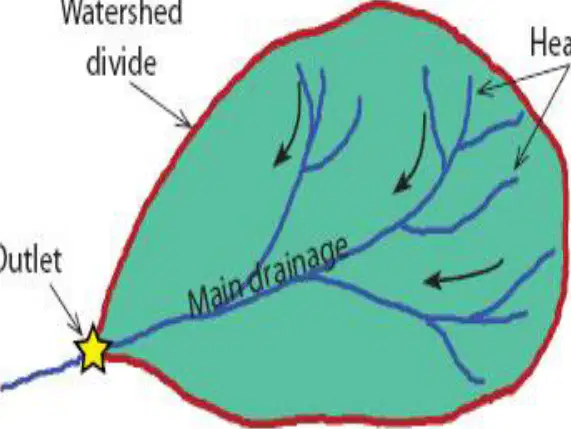
What is the term used to describe the boundary that separates one watershed from another?
Watershed divide
Contour line
Drainage line
Ridge line
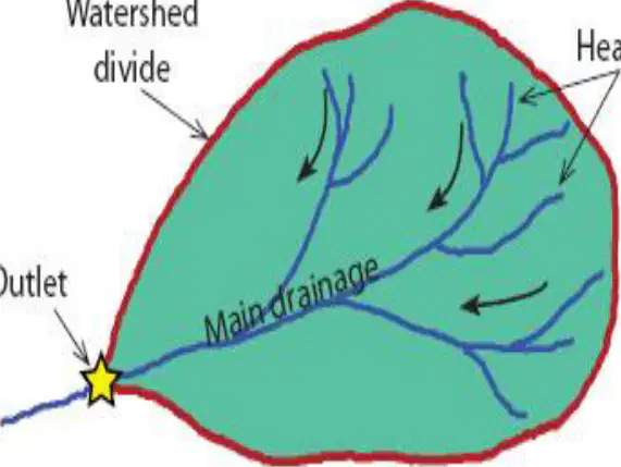
What is the main channel through which water flows in a watershed called?
Ridge line
Main drainage
Contour line
Drainage line

What is the point where water exits the watershed called?
Headwaters
Ridge line
Outlet
Contour line
What is the term used to describe the boundary that separates one watershed from another?
River Mouth
Watershed Divide
Ground Water
Aquifer
What is the name of the point where a river flows into a larger body of water, such as a lake or ocean?
Watershed Divide
Ground Water
River Mouth
Aquifer
What is the term for underground water stored in permeable rock layers?
River Mouth
Watershed Divide
Ground Water (Aquifer)
Surface Water
Which of the following statements about a watershed is correct?
A watershed must always have inhabitants.
A watershed must always have trees and vegetation.
A watershed can be sloping or relatively flat.
A watershed must always have wildlife.
What is a characteristic of a watershed regarding its water flow?
It must have a continuous river creek.
It can have a continuous or intermittent river creek.
It must have an intermittent river creek.
It does not have any river creeks.
Which of the following is NOT true about a watershed?
It can exist with or without inhabitants.
It must always have wildlife.
It can exist with or without trees and vegetation.
It can exist with or without wildlife.
What is the areal extent of a River Basin according to the classification?
Over 1000 km²
500-1000 km²
100-500 km²
Under 10 km²
Which classification corresponds to an areal extent of 500-1000 km²?
Micro Watershed
Large Watershed
Medium Watershed
Small Watershed
What is the areal extent of a Micro Watershed?
Over 1000 km²
500-1000 km²
10-100 km²
Under 10 km²
Which classification corresponds to an areal extent of 100-500 km²?
Medium Watershed
Small Watershed
Large Watershed
River Basin
What is the areal extent of a Small Watershed?
10-100 km²
500-1000 km²
Under 10 km²
Over 1000 km²
What does the notation ΔE in main stream gradient formula?
Main stream length
Change in stream elevation
Total length of streams
Basin area
What does the term "Main Stream Gradient" refer to?
The ratio of the change in elevation of the mainstream from the farthest point of the watershed outlet to the main stream length
The ratio of the basin area to the length of the basin
The ratio between the area of a circle and the actual area of the watershed
The ratio of the total basin relief to the maximum basin length
What does "Drainage Density" describe?
The ratio of the change in elevation of the watershed
The dissection of a basin that determines its response to a rainfall input
The ratio of the basin area to the length of the basin
The ratio between the area of a circle and the actual area of the watershed
How is "Basin Shape" represented?
As the ratio of the basin area and the length of the basin
As the ratio of the change in elevation of the watershed
As the ratio between the area of a circle and the actual area of the watershed
As the ratio of the total basin relief to the maximum basin length
What is "Circulatory Ratio"?
The ratio of the change in elevation of the watershed
The ratio between the area of the circle having the same perimeter as that of the watershed and the actual area of the watershed
The ratio of the basin area to the length of the basin
The dissection of a basin that determines its response to a rainfall input
What does "Elongation Ratio" measure?
The ratio of the equivalent circle and the actual perimeter of the watershed
The ratio of the change in elevation of the watershed
The dissection of a basin that determines its response to a rainfall input
The ratio of the total basin relief to the maximum basin length
What is the "Relief Ratio"?
The ratio of the total basin relief (difference between highest and lowest elevation) to the maximum basin length
The ratio of the basin area to the length of the basin
The ratio between the area of a circle and the actual area of the watershed
The dissection of a basin that determines its response to a rainfall input
What does Relative Relief represent in a watershed?
The ratio of the maximum watershed relief to the perimeter of the basin
The measure of the branching of streams in a watershed
The ratio of the number of streams in any order to the next order
The average water discharge in a watershed
What does a low value of Relative Relief indicate?
Rapid flow of water and high erosion
Gradual recession of water until it reaches the outlet
High water discharge throughout the year
High bifurcation ratio
What is Stream Order used to measure in a watershed?
The susceptibility of a watershed to flooding
The relative size of streams or the amount of branching
The maximum elevation of the watershed
The average bifurcation ratio
According to the Strahler Method, which streams are considered the smallest?
nth order streams
2nd order streams
1st order streams
Perennial streams
What does a higher bifurcation ratio indicate about a watershed?
Higher chance of flooding
Gradual recession of water
Lower water discharge
Dense vegetation in the area
What is the typical range of bifurcation ratios in a watershed?
1 to 2
2 to 5
5 to 10
10 to 15
The following are watershed descriptors, except:
Drainage density
Basin shape
Relief ratio
Stream order
Flood routing
A watershed descriptor that describes the dissection of a basin and determines its response to a rainfall input is:
Drainage density
Circulatory ratio
Relief ratio
Stream order
Stream gradient
The area of a drainage basin is approximately 10,000 acres with an average length of 2500m. The elevation of the remote place of the basin from the outlet stream is 1000m. What is the estimated time where the flow reaches the outlet stream?
0.191
0.155
0.595
0.115
The ratio of the circumference of a circle, of the same area as the basin, to the basin perimeter is called:
Circulatory ratio
Elongation ratio
Relief ratio
Circumferential ratio
The capacity of rainfall (precipitation) to effect the detachment and transport of soil particles is known as:
Erodibility
Erosivity
Effectivity
Conductivity

