

wayground logo

Free Printable Worksheets

Font size

S
M
L
XL
Worksheets

Canada and United States Physical Geography and Regions

Total questions: 60

Worksheet time: 34mins

Name
Class
Date
1.

This 400-million-year-old mountain range lies west of the Atlantic Coastal Plain. Covered in forest, these mountains have worn down over time. The highest mountain in this range is Mount Mitchell at 6,684 feet in elevation.

a)

Atlantic Coastal Plain

b)

Appalachian Mountains

c)

Central Lowlands

d)

Great Plains

e)

Rocky Mountain Range

2.

This region rises from Central Lowlands to the Rocky Mountains. It gradually rises in elevation from the east to the west. The area is used for farmland and cattle ranching.

a)

Atlantic Coastal Plain

b)

Appalachian Mountains

c)

Central Lowlands

d)

Great Plains

e)

Rocky Mountain Range

3.

This region is North America's highest mountain range located in the western United States. The mountain range runs from Mexico to Alaska. Mountains in the range are forested and rugged reaching elevations as high as 14,440 feet above sea level.

a)

Atlantic Coastal Plain

b)

Appalachian Mountains

c)

Central Lowlands

d)

Great Plains

e)

Rocky Mountain Range

4.

Covers most of Greenland, the Hudson Bay, and reaches into the United States along the Great Lakes. Most of the land is not farmable and sparsely populated, but rich with minerals such as iron, gold, copper, and uranium. The area is a rocky region, flat plains with hills and lakes, high mountains in northeast, and the south covered with forests.

a)

Gulf Coastal Plain

b)

Coastal Ranges

c)

Central Lowlands

d)

Great Basin

e)

Canadian Shield or Laurentian Plateau

5.

A large self-contained drainage basin of the western United States, including most of Nevada and parts of Utah, Wyoming, Idaho, Oregon, and California. Situated in the rain shadow of the Sierra Nevada, the area is mostly arid. This region contains the lowest point in North America in Death Valley which has an elevation of 282 feet below sea level.

a)

Gulf Coastal Plain

b)

Coastal Ranges

c)

Central Lowlands

d)

Great Basin

e)

Canadian Shield or Laurentian Plateau

6.
What river connects the Great Lakes to the Atlantic Sea?
a)
Mississippi River
b)
Ohio River
c)
Amazon River
d)
St. Lawrence River
7.
This mountain range along the East Coast of the US is the oldest range in North America.
a)
Appalachian Mountains
b)
Rocky Mountains
c)
Cascade Mountains
d)
Andes Mountains
8.
On which of the following regions would you most likely find good land for grazing animals such at cattle?
a)
Atlantic Coastal Plain
b)
Great Plains
c)
Canadian Shield
d)
Rocky Mountains
9.
The continental DIVIDE is the high point in a landmass that determines the direction that _______ flow.
a)
rivers
b)
mountains
c)
sands
d)
soup
10.
What large mountain range is pictured here?
a)
Catskill Moutains
b)
Rocky Moutanins
c)
Appalachian Mountains
11.
Which two physical features do the United States and Canada share?
a)
Appalachian Mountains and Mississippi River
b)
St. Lawrence Seaway and Rocky Mountains
c)
Mississippi River and the Great Lakes
d)
Rocky Mountains and the Great Lakes
12.
Five large lakes located between the United States and Canada containing the largest surface area of fresh water in the world
a)
Atlantic Ocean
b)
Great Lakes
c)
Lake Lanier
d)
Gulf of Mexico
13.

The Atlantic Ocean is located on the ______ Side of Canada.

a)

Eastern

b)

Western

c)

Southern

d)

Northern

14.

The Pacific Ocean Is Located On The _______ Side of Canada.

a)

Northern

b)

Eastern

c)

Southern

d)

Western

15.

The Great Lakes Can Be Found..

a)

Only in Canada

b)

Only in the USA

c)

Both Canada and the USA

16.

The Canadian Shield is the largest region in Canada.

a)

True

b)

False

17.
What region is this?
a)
Canadian Shield
b)
Appalachian Highlands
c)
Great Plains
d)
Interior Lowlands
18.
What region is this
a)
Rocky Mountains
b)
Appalachian Highlands
c)
Basin and Range
d)
Interior Lowlands
19.
What region is this?
a)
Coastal Plains
b)
Basin and Range
c)
Canadian Shield
d)
Great Plains
20.
What body of water is located North of Canada? 
a)
Pacific Ocean
b)
Atlantic Ocean 
c)
Arctic Ocean 
d)
Great Lakes
21.
What body of water is located on the West coast of Canada?
a)
Pacific Ocean
b)
Atlantic Ocean 
c)
Arctic Ocean 
d)
Great Lakes 
22.
What body of water is located on the East coast of Canada?
a)
Pacific Ocean
b)
Atlantic Ocean
c)
Arctic Ocean 
d)
Great Lakes
23.

The arrows are pointing to which North American mountain range?

a)

Appalachian Mountains

b)

Adirondack Mountains

c)

Canadian Mountains

d)

Rocky Mountains

24.

Nearly 90% of Canada's population lives

a)

within 100 miles of the border of the United States.

b)

beside the St. Lawrence waterway.

c)

along the west coast of British Columbia.

d)

in the province of Quebec.

25.
What is geographic feature letter D?
a)
Ohio River
b)
Mississippi River
c)
Missouri River
d)
Colorado River
26.

Which physical feature on the map is known as the United States longest river and a means for transportation and trade?

a)

Saint Lawrence River

b)

Colorado River

c)

Ohio River

d)

Mississippi River

27.
What land form is this?
a)
valley
b)
plain
c)
volcano
d)
canyon
28.
What land form is this?
a)
valley
b)
canyon
c)
plain
d)
mountain
29.
a)
A. Desert
b)
B. Lake
c)
C. Plains
d)
D. River
30.
a)
A. Hills
b)
B. River
c)
C. Desert
d)
D. Mountains
31.
Name this landform
a)
volcano
b)
hill
c)
river
d)
island
32.

What is a tributary?

a)

a concert honoring someone who has died

b)

where a river begins

c)

a river that starts in a mountain

d)

a smaller river/stream that drains into a larger river
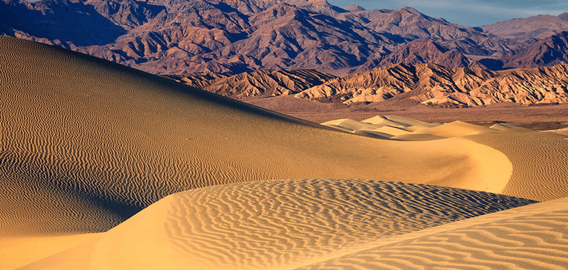
33.

What is this?

a)

canyon

b)

desert

c)

volcano

34.
a)
Lake
b)
Pond
c)
Gulf
35.

What does the dark shaded area represent?

a)

Mexico

b)

Brazil

c)

Russia

d)

Canada

36.
What type of lines RUN north to south and MEASURE how far EAST or WEST you are?
a)
Longitude
b)
Latitude 
37.
What type of lines RUN east to west and MEASURE how far north or south you are from the equator?
a)
Longitude
b)
Latitude 
38.
What is a land area that is surrounded by water?
a)
Lake
b)
Island
c)
Gulf
d)
Peninsula
39.
Arm of an ocean or sea that is partly enclosed by land, usually larger than a bay. 
a)
Gulf
b)
Island
c)
Tributary
d)
Bay
40.
Another name for latitude lines
a)
meridians
b)
parallels
41.
0 degree latitude line
a)
Equator
b)
Prime Meridian
c)
Top Parallel
d)
North Pole
42.
Another name for longitude lines
a)
meridians
b)
parallels
43.
A piece of land that is surrounded by water on 3 sides
a)
Peninsula
b)
Tributary
c)
Plateau
d)
Plain
44.
What ocean is EAST of the United States?
a)
Indian
b)
Atlantic
c)
Pacific
d)
Arctic
45.
What ocean is WEST of the United States?
a)
Pacific
b)
Atlantic 
c)
Southern
d)
Arctic
46.
0 degree longitude line
a)
South Pole
b)
Prime Meridian
c)
Parallel Line
d)
Equator
47.
Which river is in the NORTHWEST United States?
a)
Colorado River
b)
Columbia River
c)
Ohio River
d)
Mississippi River
48.
Which river borders the US and Mexico?
a)
St. Lawrence River
b)
Columbia River
c)
Colorado River
d)
Rio Grande
49.
Which river borders the US and Canada?
a)
St. Lawrence River
b)
Ohio River
c)
Columbia River
d)
Rio Grande
50.
Which river is pictured?
a)
Mississippi River
b)
Missouri River
c)
Columbia River
d)
Ohio River
51.

What is the longest river in Canada?

a)

Mackenzie River

b)

Mount Logan

c)

Atlantic Ocean

d)

Great Bear Lake

52.

What region is Virginia in?

a)

Northeast

b)

Midwest

c)

Southeast

d)

Pacific

53.

Which region is in green?

a)

Non-contiguous

b)

Rocky Mountains

c)

Western

d)

Southeast

54.

Which state is NOT in the Pacific Region?

a)

California

b)

Nebraska

c)

Oregon

d)

Washington

55.

Which region is in red?

a)

Non-contiguous

b)

Rocky Mountains

c)

Western

d)

Southeast

56.
What physical feature does the shaded area represent?
a)
Rocky Mountains
b)
St. Lawrence River
c)
Canadian Shield
d)
European Plain
57.
Mountains, rivers, lakes, deserts are all types of?
a)
Landforms
b)
Water
c)
Maps
d)
Climates
58.

Features of a place that set it apart from other places.

a)

movement

b)

location

c)

place

d)

human environment interactions

e)

region

59.
Are the regions defined by this map based on physical (natural) or human factors?
a)
physical factors
b)
human factors
60.

Which Native American region hunted polar bears and trained huskies.

a)

Arctic

b)

Northwest Pacific Coast

c)

Southwest

d)

Northeast
