
Font size
 Worksheets
ES - Unit 3 - Terrestrial Biomes
Total questions: 41
Worksheet time: 2hrs 39mins
What is the best definition for a biome?
land-based ecosystems with uniq biotic and abiotic factors
a collection of individual species in one location.
a type of weather pattern in a region.
a small area with random plant and animal life.
What are the two most significant abioitic factors for biomes?
soil
precipitation
air quality
temperature
Label the following on the map
Label the latitude zones on the map
Label the angle's of incoming sunlight.
Seasons in temperate regions are the result of the Earth’s tilt and orbit.
During our winter, the (a) hemisphere is tilted away from the sun.
The southern hemisphere is experiencing (b) .
During our summer, the northern hemisphere is tilted (c) the sun.
The (d) hemisphere is experiencing winter.
Day length is highly (a) near the equator (~12hr/day)
Day length becomes (b) in the temperate latitudes, ( (c) /day)
Day length reaches (d) periods of light and darkness at the poles.
Select the most productive areas
Latitude and Temperature
The amount of solar energy that reaches Earth’s surface depends on latitude. Areas near the equator receive direct sunlight year-round, while regions near the poles receive less direct sunlight, leading to colder climates. The graph below shows the average yearly temperature at various latitude
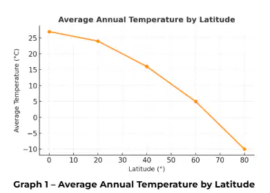
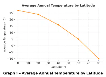
Based on the graph, which latitude experiences the warmest average annual temperature?
0°
20°
40°
60°
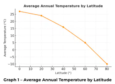
Which factor best explains why temperatures decrease with increasing latitude?
Higher wind speeds
Lower angle of incoming sunlight
ncreased rainfall
More volcanic activity
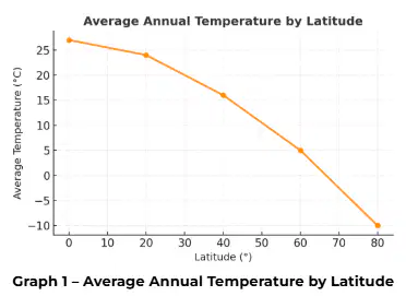
If global temperatures rise by 2°C across all latitudes, which biome would likely experience the smallest relative change?
Tropical rainforest
Tundra
Taiga
Temperate forest
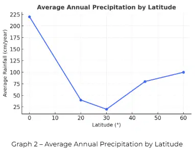
Latitude and Precipitation
Biomes differ not only in temperature but also in precipitation. Rainforests near the equator receive over 200 cm of rain annually, while deserts at 30° N and 30° S receive less than 25 cm. The graph below compares average annual rainfall across latitudes.
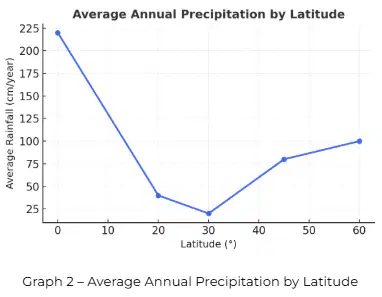
According to the graph, which latitude has the lowest annual rainfall?
0°
0° N/S
30° N/S
60° N/S

What pattern is shown between 0° and 30° latitude?
A. Precipitation increases steadily
B. Precipitation decreases from equator to subtropics
C. Precipitation remains constant
D. Precipitation peaks at 30° latitude
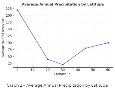
Which biome would you expect at 30° latitude based on the precipitation data?
A. Rainforest
B. Desert
C. Temperate forest
D. Tundra
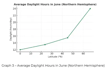
Latitude, Daylight, and Productivity
The Earth’s tilt causes differences in daylight hours throughout the year. The chart below shows average daylight hours in June for locations at different latitudes in the Northern Hemisphere.
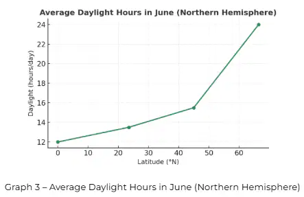
According to the graph, which latitude experiences constant daylight in June?
0°
23.5°
45°
66.5°
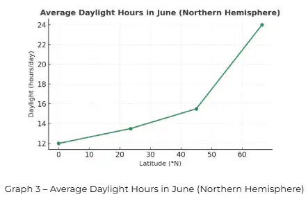
Which latitude shows the least change in day length throughout the year?
0°
23.5°
45°
66.5°
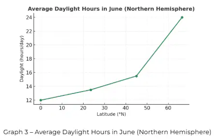
Based on the data, which latitude likely has the highest primary productivity year-round?
A. 0°
B. 23.5°
C. 45°
D. 66.5°
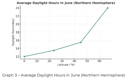
Which of the following statements best summarizes the relationship between latitude and primary productivity?
A. Productivity is highest where light and temperature are most consistent.
B. Productivity is greatest where day length varies the most.
C. Productivity is highest at the poles due to 24-hour sunlight in summer.
D. Productivity does not vary by latitude.
Louisiana Wetlands and Latitude
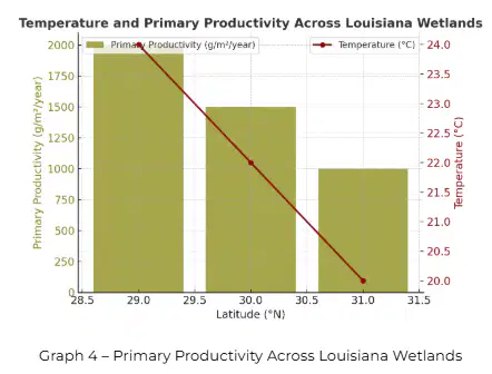
Louisiana’s coastal wetlands are located between 29°N and 31°N latitude, within the subtropical zone. This latitude receives abundant sunlight, warm temperatures, and moderate to high rainfall throughout the year, which together create highly productive ecosystems.
Despite their high productivity, Louisiana’s wetlands are threatened by rising sea levels, subsidence (land sinking), and reduced sediment flow from the Mississippi River. These changes alter salinity, temperature, and nutrient levels, reducing the wetlands’ ability to support species such as alligators, herons, shrimp, and redfish.
The graph below shows how primary productivity (biomass produced per m² per year) changes along a north-south transect through Louisiana’s wetland ecosystems, from coastal marshes near the Gulf of Mexico to inland forests farther north.
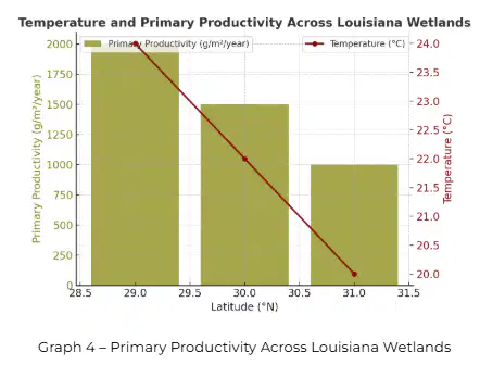
Based on the graph, which factor appears to have the strongest influence on primary productivity in Louisiana wetlands?
Latitude and temperature
Elevation and soil type
Predator-prey relationships
Air pressure differences
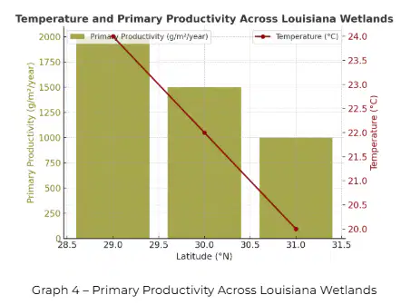
As latitude increases from 29°N to 31°N, how do both temperature and productivity change?
Both increase
Both decrease
Temperature increases but productivity decreases
Temperature decreases but productivity increases
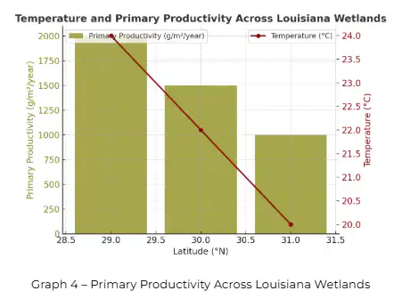
Which statement best explains why Louisiana’s wetlands have higher biodiversity than inland ecosystems?
Coastal wetlands are closer to the poles and have more sunlight.
Warm temperatures and high rainfall promote more plant and animal life.
Cold water and less sunlight favor long-lived species.
Biodiversity is unrelated to abiotic conditions.
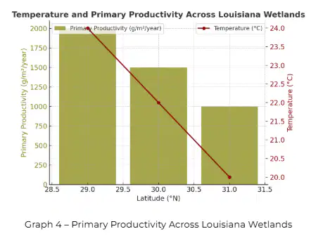
If sea level rise causes saltwater intrusion into inland swamps, what would most likely happen to primary productivity?
It would increase due to nutrient mixing.
It would decrease due to loss of freshwater vegetation.
It would remain constant across all latitudes.
It would shift toward higher latitudes.
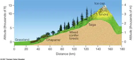
Altitude is the (a) above sea level.
As altitude (b) , average temperature and primary productivity (c) .
This is due to (d) decreasing as we increase in altitude.
More solar heat at the equator causes warm, (a) air to (b) .
As the air rises, it (c) , dries out, then (d) towards the subtropics.
Convection cells are rotating bodies of air caused by this warming and cooling.
Warm air brings wet weather
Cool air brings (e) weather
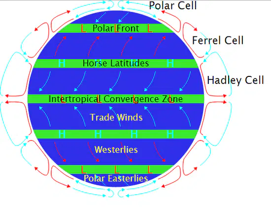
(a) winds are caused by the Earth’s rotation, and tend to move in the same direction.
(b) winds: From the tropics westward towards the equator.
(c) : From the subtropics eastward towards the midlatitudes.

Uneven heating across the Earth also creates the (a) -- a moving system of deep (b) that circulate heat.
Warm currents bring (c) weather
Cold currents bring (d) weather

Water does not gain and lose heat as quickly as air, leading to:
(a) temperatures in the summer
(b) temperatures in the winter.
Louisiana: Ocean Currents and Climate
Louisiana lies near the Gulf of Mexico, at a low elevation and warm latitude (~30°N). The Loop Current, a warm ocean current in the Gulf, transfers heat from the Caribbean northward.
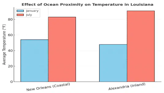
Because water warms and cools more slowly than air, the Gulf stabilizes coastal temperatures, keeping winters mild and summers humid.
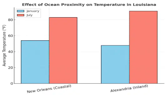
Based on the data, which statement best explains the difference between New Orleans and Alexandria’s temperatures?
Coastal areas warm and cool more slowly because of the nearby Gulf waters.
The Gulf of Mexico causes higher altitude in coastal regions.
Inland and coastal regions have identical temperature ranges.
Inland areas stay cooler year-round because of ocean influence.
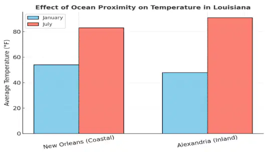
If the Loop Current weakened and brought less warm water north, which would most likely occur?
Louisiana winters would become cooler.
Louisiana summers would become hotter.
Louisiana would receive less rainfall.
The average altitude of Louisiana would rise.
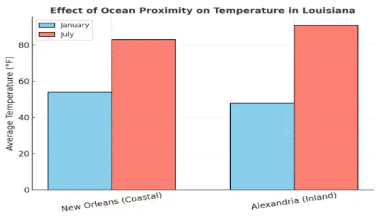
Which statement best describes how Louisiana’s low altitude and proximity to warm ocean currents affect its biome?
They produce cold, dry air and desert vegetation.
They promote a humid subtropical climate with high productivity.
They reduce precipitation and temperature variation.
They prevent convection and rainfall.
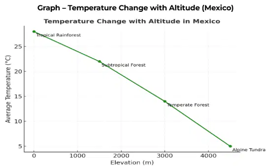
Mexico: Altitude and Temperature
Mexico spans from sea level along the coasts to mountains exceeding 18,000 ft (5,500 m). The graph below shows how temperature decreases with altitude.
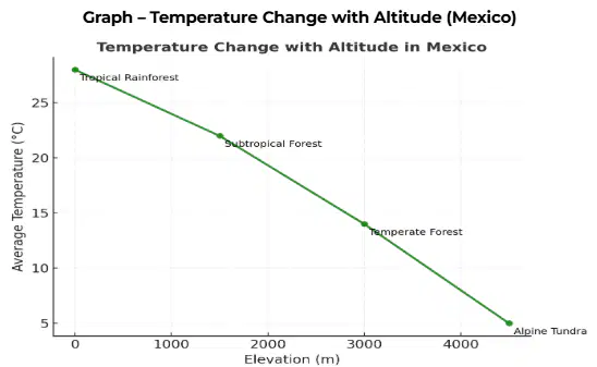
Which factor explains why temperatures decrease as altitude increases?
Heat is trapped more efficiently at higher elevations.
The sunlight angle increases with altitude.
Air pressure and heat energy decrease with height.
The atmosphere becomes denser at higher altitudes.
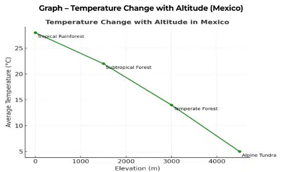
A city like Mexico City (2,200 m) has cooler temperatures than coastal Veracruz even though it is closer to the equator. Which factor explains this?
Altitude has a stronger effect on temperature than latitude in this case.
Ocean currents cause Veracruz to be colder.
Mexico City receives less sunlight.
Coastal areas heat more quickly due to thinner air.
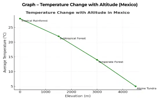
If global temperatures increased by 2°C, how might the biomes at high altitudes in Mexico change?
Alpine tundra would expand to lower elevations.
Forests would shift upward to higher elevations.
Temperature zones would remain stable.
Tropical forests would disappear completely.
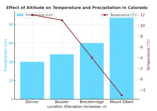
Colorado: Altitude and Continental Climate
Colorado is located at mid-latitude (~39°N) and has some of the highest elevations in North America. Because it is far from large oceans, it experiences a continental climate—hot summers, cold winters, and low humidity.
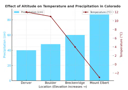
According to the data, which location has the coldest average temperature?
Denver
Boulder
Breckenridge
Mount Elbert
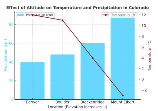
Which trend is shown in the data as altitude increases?
Both temperature and precipitation remain constant.
Temperature increases while precipitation decreases.
Temperature decreases while precipitation increases.
Temperature and precipitation both decrease.
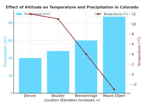
Which statement best explains Colorado’s low humidity compared to Louisiana?
High altitude and distance from oceans reduce available moisture.
Convection cells bring moist equatorial air to Colorado.
High altitude increases cloud formation and humidity.
Ocean currents near Colorado cool the air.
Compare Louisiana, Mexico, and Colorado. Which statement best summarizes how altitude and oceans shape their climates?
Neither altitude nor ocean proximity affects weather patterns.
Altitude and ocean currents both increase temperature.
Altitude decreases temperature, while ocean proximity stabilizes it.
Both altitude and ocean proximity reduce precipitation.
Match the correct phenomenon with the defintion
- warm air from the lake becomes less dense and floats up. As it moves and condenses with other warm air, it cools and builds up density.
Lake Effect Snow
Moist, warm air comes from the continent
As air rises over mountains, it cools - causing moisture to condense and fall as precipitation
Rain Shadow
warm waters shift to the coast of South America, fueling more rainfall in the Western U.S.
El Nino
Match the phenomenon with the figure

Rainshadow

Lake Effect Snow

El Nino

Altitude

Ocean Currents
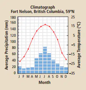
What is the best definition of climatorgraph?
A graph that shows average temperature and precipitation over a typical year.
Organize these options into the right categories
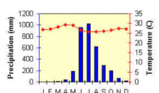
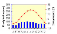
Organize these options into the right categories
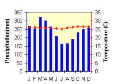
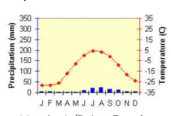
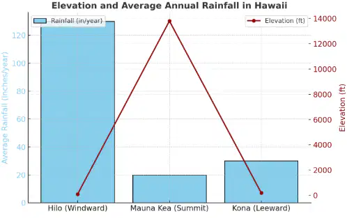
🌴Hawaii – The Rain Shadow Effect
Moist trade winds from the Pacific Ocean blow toward the islands of Hawaii. As the air rises over the volcanic mountains, it cools, condenses, and produces heavy rainfall on the windward (northeastern) side. After passing over the mountains, the air descends on the leeward (southwestern) side, becoming warmer and drier, creating semi-arid conditions.
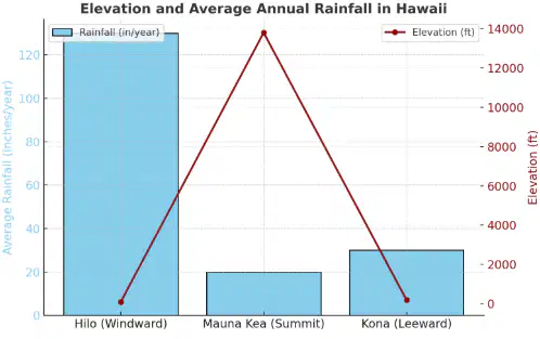
Based on the data, which statement best describes why Hilo receives the most rainfall?
It is located on the leeward side of the island.
It is at the highest elevation.
It is on the windward side where moist air rises and cools.
It is farthest from ocean currents.
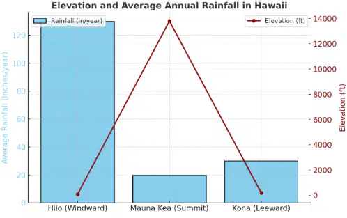
As air rises over Mauna Kea, which process primarily causes rainfall on the windward side?
Evaporation
Condensation due to cooling
Sublimation
Radiation heating
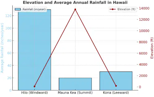
What climatic pattern is most likely found on the leeward side of Hawaii?
Cooler and wetter than average
Warm and dry
Cold and humid
Stormy and windy
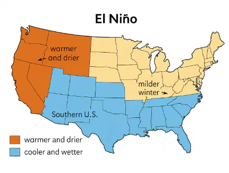
🌊 Niño and U.S. Temperature Patterns
During El Niño events, trade winds weaken, reducing upwelling in the eastern Pacific. Warmer water spreads eastward, altering weather patterns across the globe.
The U.S. typically experiences warmer winters in the north and cooler, wetter conditions in the south.
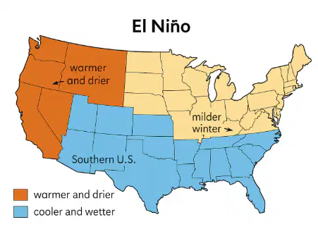
During an El Niño winter, which U.S. region is most likely to experience increased rainfall?
Great Plains
Pacific Northwest
Gulf Coast and Southeast
New England
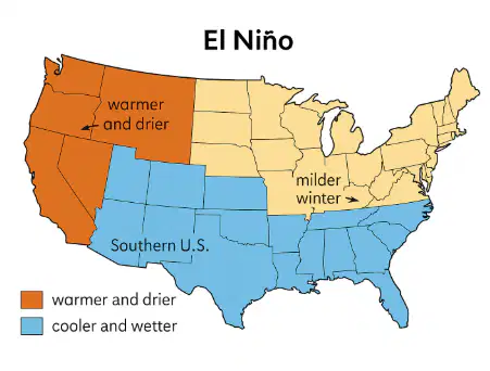
Which process leads to the eastward spread of warm surface water during El Niño?
Strengthening of trade winds
Weakening of trade winds
Intensified upwelling along South America
Cooling of the western Pacific
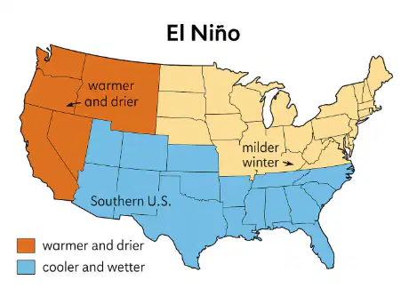
During a strong El Niño year, farmers in California may experience:
Drought and reduced water supply
Increased rainfall and flooding
Colder-than-normal summer temperatures
Stronger trade winds and dry air
❄️ Buffalo, New York – Lake-Effect Snow
Cold, dry air from Canada passes over the warmer waters of the Great Lakes. As it moves across Lake Erie, the air absorbs heat and moisture, forming clouds. When this air reaches land near Buffalo, it cools again, releasing heavy lake-effect snow.
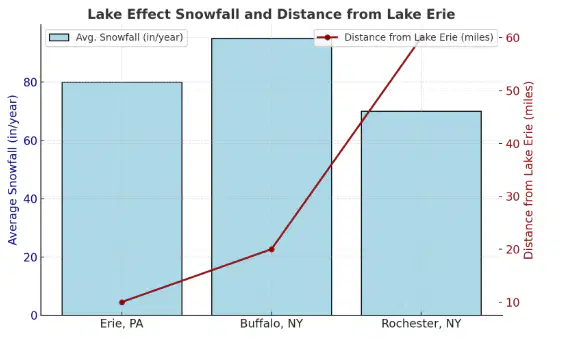
Based on the data, which location receives the most lake-effect snow and why?
Buffalo – because it is at the highest elevation
Rochester – because it is farthest from the lake
Buffalo – because it is downwind of Lake Erie’s prevailing wind
Erie – because it has the warmest air mass
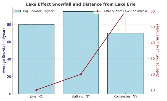
What happens to the air mass as it moves from the lake onto the land near Buffalo?
It decreases in density and causes evaporation
It becomes drier and rises
It cools, condenses, and releases snow
It warms rapidly and holds more moisture
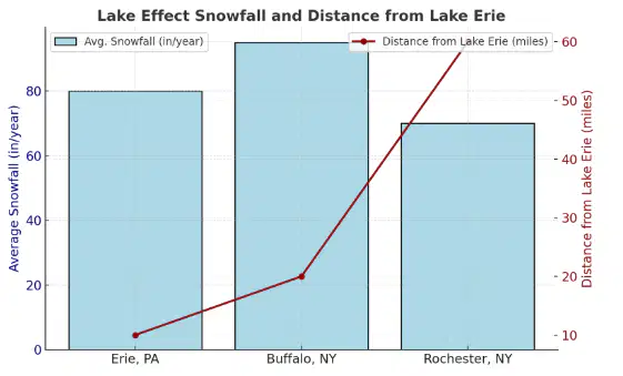
How might a colder-than-average winter affect the amount of lake-effect snow near Buffalo?
Snowfall would increase as the lakes freeze.
Snowfall would decrease because frozen lakes reduce evaporation.
Snowfall would remain constant regardless of temperature.
Snowfall would increase due to stronger winds.
🌡️Phoenix, Arizona Climate
Phoenix, Arizona, is located in the Sonoran Desert, one of the hottest and driest regions in North America. The city sits far inland in the southwestern United States and is surrounded by mountain ranges. Because Phoenix is so far from major bodies of water like oceans or large lakes, it does not receive much moisture from the atmosphere.
Precipitation Patterns
Phoenix receives very little rainfall throughout the year. Most months receive less than 1 inch (25 mm) of precipitation. The city usually has:
Dry winters
Very dry springs
Slightly wetter summers, but still low rainfall overall
This is because most weather systems that bring rain to the rest of the U.S. lose moisture before reaching Arizona. In addition, the mountains surrounding Phoenix block moist air from the Pacific Ocean and Gulf of California, preventing clouds and rain from forming.
Temperature Patterns
Phoenix has extremely hot summers, with temperatures often exceeding 38–43°C (100–110°F) in June, July, and August. Winter temperatures are mild, typically ranging from 12–20°C (55–68°F).
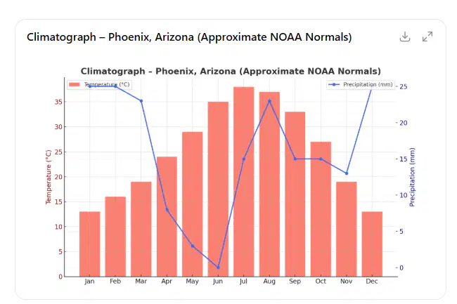
A climatograph for Phoenix shows:
Very high temperatures during summer
Relatively warm winters
Consistently low precipitation in almost every month
The graph below shows average monthly climate data for Phoenix, Arizona (30°N) — a region with low precipitation and high summer temperatures.
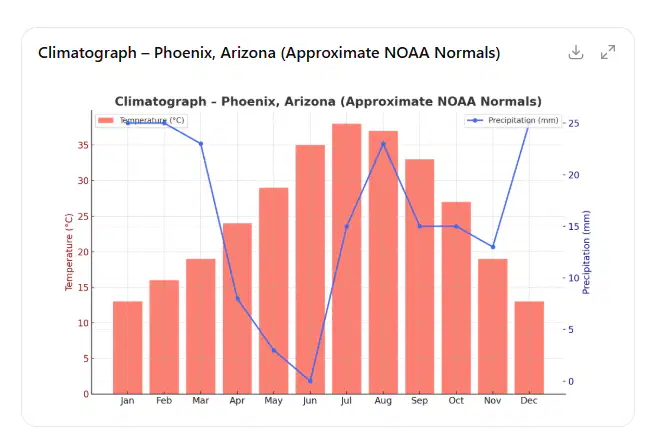
What does the pattern of precipitation suggest about Phoenix’s climate?
It experiences high rainfall in summer months.
It has dry conditions most of the year with limited rainfall.
It receives consistent rainfall each month.
It has a humid tropical climate.
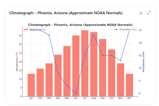
During which months does temperature peak while precipitation is lowest?
September–October
June–August
April–May
December–January
Why does Phoenix have low rainfall despite high summer temperatures?
The city’s high latitude reduces evaporation.
The surrounding mountains block moist air from reaching it.
The Gulf of Mexico provides excess rainfall.
Cooler air at higher elevations
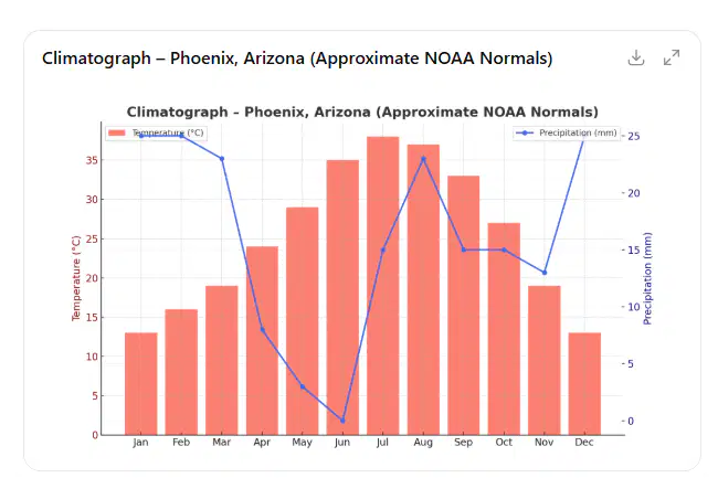
If you compared this climatograph to one from New Orleans, what difference would you expect?
New Orleans would show higher precipitation and milder temperatures.
New Orleans would have lower humidity and cooler summers.
Phoenix would have higher rainfall and cooler winters.
Both would have similar patterns of temperature and rainfall
Organize these options into the right categories
between the tropics and temperate latitudes.
characterized by high temperatures and low rainfall.
located along coastlines, often influenced by ocean currents.
characterized by mild temperatures, low precipitation, and fog.
located in the rain shadow of mountain ranges.
experiences distinct seasons with hot summers and cold winters.
characterized by extremely low temperatures.
receives very little precipitation, mostly as snow.


Organize these options into the right categories
located near the equator between tropical forests and subtropical deserts.
grasslands dominated by grasses and few trees
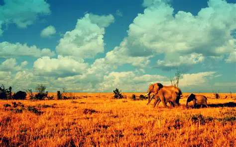
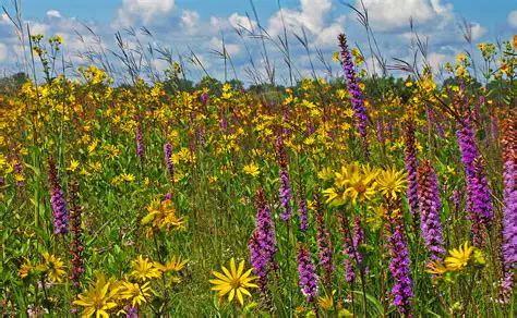

Organize these options into the right categories
high rainfall and are consistently warm.
diverse plant and animal species.
located near the equator.
four distinct seasons.
deciduous and coniferous trees.
moderate rainfall throughout the year.
characterized by hot, dry summers and mild, wet winters.
often found in coastal regions.
home to drought-resistant plants like shrubs and small trees.
characterized by long, cold winters.
short growing seasons with limited vegetation.
predominantly coniferous trees such as spruce and fir.
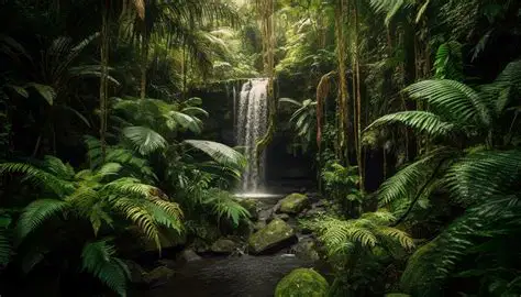
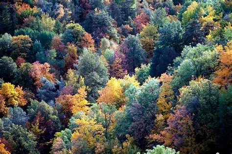

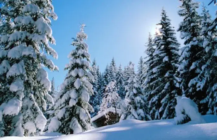
The theory of island biogeography predicts that the species richness or biodiversity of an island depends on two factors:
As island (a) increases, species richness also (b) .
As (c) from the mainland increases, species richness (d) .
Islands have many species that are (a) , or not found anywhere else in the world.
Evolved due to the (b)
Islands are (c) due to the number of endemic species present.
Many small or distant islands lack (a) due to the limited food.
Increases risk of extinction from (b) .
The lack of predators can lead to (c) – a lack of fear of larger animals.
Organize these Environmental Concerns about Urban Ecosystems into the right categories
air, water, noise, light
causes cities to be warmer due to the absorptive properties of asphalt and pavement
block wind flow, causing updrafts and downdrafts.
divide natural areas up into smaller pieces
reduce gene flow between populations
Organize these options into the right categories
variety of food sources
specific food sources
wide range of environmental conditions
highly adaptable
tend to be invasive species
narrow range of environmental conditions
adpated to one niche
tend to be endemic species
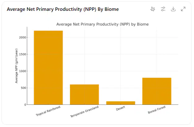
Desert and Grassland Productivity
Passage:
Biomes differ in primary productivity based on precipitation, temperature, and soil quality. Deserts have low net primary productivity (NPP) due to limited water. Grasslands support moderate productivity because deep root systems allow rapid regrowth after fires.
Graph 1 – Average NPP by Biome
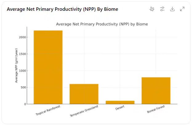
According to the graph, which biome has the lowest NPP?
Tropical rainforest
Desert
Grassland
Boreal forest
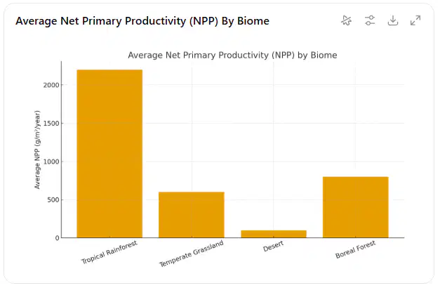
What factor most limits productivity in deserts?
Soil nutrients
High herbivore activity
Temperature
Water availability
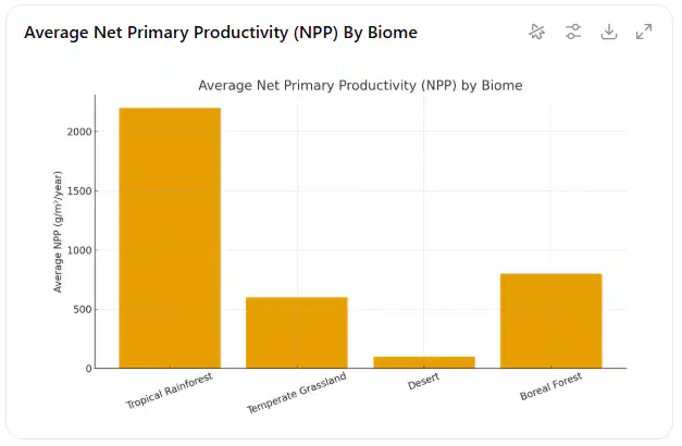
Grasslands experience frequent fires, yet maintain moderate productivity. Which explanation is most supported?
Fire adds harmful toxins to soil
Grass species store energy in deep roots
Herbivores fertilize the soil
Most grasslands are located at high altitude
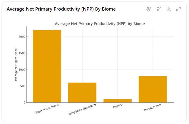
If climate change increases rainfall in a desert region, which biome might replace it over time?
Temperate deciduous forest
Grassland
Tundra
Alpine forest

Succession and Forest Recovery
Passage:
After a volcanic eruption forms new land, primary succession begins. Pioneer species such as lichens and mosses break down rock and form early soil. Over centuries, shrubs, grasses, and forests may follow.
In contrast, secondary succession occurs after disturbances like wildfires, where soil remains intact.
Table 2 – Recovery Times Across Biomes

Which disturbance leads to the longest recovery time?
A. Lava flow
B. Wildfire
C. Flooding
D. Seasonal drought

Why does wildfire recovery occur more quickly in temperate forests?
Soil remains intact and seed banks survive
Trees photosynthesize faster after a fire
Herbivores increase biodiversity
Rainfall decreases soil nutrients

Based on Table 2, which statement best explains the difference between primary and secondary succession
Primary succession involves soil formation from bare rock
Both succession types begin with mature forests
Secondary succession eliminates all soil and nutrients
Primary succession happens only after wildfire

If volcanic activity produced a new island near Hawaii, which biome would likely form first?
Tropical rainforest
Shrubland
Lichen-dominated pioneer community
Temperate grassland

