
 Worksheets
8ES3 Unit 3 Test
Total questions: 40
Worksheet time: 32mins
The example is given - provide the term that describe the example
(a) Alpine glaciers carving valleys.
(b) Terminal moraine at glacier’s end.
(c) PlainArea in front of a glacier.
(d) Boulder far from its source rock.
(e) Curved hill of sand and gravel.
The example is given - provide the term that describe the example
(a) Volcanoes forming islands, deposition forming deltas.
(b) Erosion wearing down cliffs or mountains.
(c) Freeze-thaw cracking rocks.
(d) River carrying sediment downstream.
(e) Sand dunes forming or delta growth.
The example is given - provide the term that describe the example
(a) Landslide or rockfall.
(b) After heavy rain on steep hills.
(c) Tilted fence posts on slopes.
(d) Mississippi River valley.
(e) Mountains, valleys, plains.
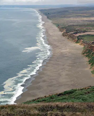
A coastline is constantly reshaped by waves hitting the shore. Strong waves remove sand from some beaches, while other areas gain new sand carried by ocean currents.
Which statement describes what is happening?
Waves cause only constructive changes by adding sand to beaches.
Waves cause only destructive changes by removing sand from beaches.
Waves cause both constructive and destructive changes depending on the location.
Which statement best defines erosion?
Movement of sediment by wind or water
Creation of rocks from cooling magma
Breaking rocks only without transport
Settling of particles at the stream mouth
Which process is the opposite of erosion?
Deposition of transported sediment
Weathering by chemical reactions
Abrasion of pebbles in streams
Suspension of silt in fast flow
A builder clears trees from a steep hill before heavy rain. What is the most likely result?
Increased erosion and more sediment runoff
Decreased erosion and cleaner runoff
No change to erosion or runoff
Instant deposition at the hilltop
Which factor is NOT an agent of erosion?
wind moving sediment
water carrying particles
plants holding soil
gravity pulling materials
Which is a form of mass wasting?
loess formed by wind
creep on a hillside
sorting by water flow
outwash from glaciers
Which landform forms when a high‑gradient stream exits a narrow canyon and spreads sediment onto a plain?
Moraine ridge beside glacier
Alluvial fan cone‑shaped apron
Outwash meltwater plain
Talus slope of broken rock
Sediment sorting improves the longer erosion and transport continue. Why does extended transport usually produce well‑sorted deposits?
Particles mix randomly in short trips
Repeated movement separates by size and mass
Water adds new minerals to all grains
Wind compacts grains into one layer
A home sits on a treeless hill with several large trees but little ground cover. Which strategy best reduces soil erosion around the house?
Remove trees to lower wind speed
Plant deep‑rooted grasses and shrubs
Pave the entire slope with concrete
Increase slope angle to drain faster
Mass wasting can be considered a type of __________.
erosion
deposition
weathering
glaciation
A large deposit of sediment that forms where a stream enters a large body of water is a(n) __________.
delta
meander
dune
alluvial fan
A(n) __________ is a C-shaped curve in a stream.
meander
delta
loess
dune
A pile of windblown sand is a(n) __________.
dune
loess
alluvial fan
till
A pile of angular rocks and sediment from a rockfall is called __________.
talus
loess
delta
drumlin
A mixture of various sizes of sediment deposited by a glacier is called __________.
till
loess
alluvial fan
meander
An apron of sediment formed where a stream flows from a steep slope onto flat land is a(n) __________.
alluvial fan
delta
dune
meander
A new neighborhood is being built on a hillside. Workers remove most of the trees and shrubs before construction begins. After several weeks of heavy rain, the hillside begins to erode rapidly.
Which change would most effectively reduce erosion on the slope?
Adding more sidewalks to cover exposed soil
Replanting native grasses and shrubs
Increasing the angle of the slope to speed water flow
A river flowing through a wide valley slows down as it approaches a larger body of water. Over many years, the river drops the sediment it was carrying. What landform is most likely to develop at this location?
A V-shaped canyon
delta
oxbow lake
A steep riverbed
A large deposit of sediment that forms where a stream enters a large body of water is a(n) ___________________________.
delta
canyon
plateau
valley
Mass wasting can be considered a type of ___________________________.
erosion
deposition
condensation
evaporation
A landscape shows a U-shaped valley with nearby eskers on a sandy plain. What process most likely formed these features?
Glacial erosion carved valley; meltwater built eskers
River erosion carved valley; wind built eskers
Tectonic uplift formed valley; waves built eskers
Mass wasting carved valley; longshore drift built eskers
Label the correct locations of
Deposition
Erosion
Weathering
Deposition
Erosion
Weathering
Select the area on the stream table were DEPOSITION is occurring.
Select the scenario in which human activity could cause mass wasting and the scenario in which human activity could help prevent it.
Building roads on steep slopes and planting vegetation to stabilize soil.
Planting trees on flat land and removing rocks from riverbeds.
Constructing dams in deserts and paving city streets.
Digging small holes in gardens and installing street lights.
Analyze the following statement: A stream can be an agent of erosion and an agent of deposition, but usually not at the same time.
A stream can erode and deposit materials, but typically not simultaneously.
A stream can only erode materials, never deposit them.
A stream can only deposit materials, never erode them.
A stream always erodes and deposits materials at the same time.
Defend the following statement: A dam on a river can increase erosion on ocean beaches downstream. Use the terms sediment, dam, longshore current, and beach in your defense of the statement.
A dam traps sediment, reducing the amount that reaches the beach, so longshore currents have less material to deposit, increasing beach erosion.
A dam increases the flow of sediment to the beach, causing longshore currents to build up the beach and decrease erosion.
A dam has no effect on sediment or beach erosion because longshore currents are unaffected by river dams.
A dam causes more sediment to be deposited on the beach, preventing erosion by longshore currents.
A family builds a home on top of a hill. The hill has several large trees but almost no grass or shrubs. The family wants to prevent the soil on the hill around the house from continuing to erode. Which strategy would best help them stop the erosion?
Plant grass and shrubs to hold the soil in place.
Remove the large trees to allow more sunlight.
Cover the soil with concrete.
Dig trenches to direct water downhill.
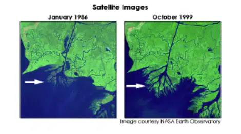
The two satellite images show the changes over time to an area where a river flows into a body of water. The location of a specific change is marked by an arrow.
Select the two constructive geologic processes that caused the change marked by the arrow.
sedimentation
delta formation
tectonic activity
seafloor spreading
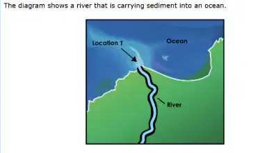
What will happen to most of the sediment being transported by the river water when it first enters the ocean at Location T in the diagram?
Most of the sediment will erode beaches.
Most of the sediment will dissolve in the water.
Most of the sediment will be evenly disturbed throughout the ocean.
Most of the sediment will collect near the mouth of the river near the shore.
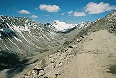
This image shows what kind of landform?
U-shaped valley
river channel
canyon
hanging valley
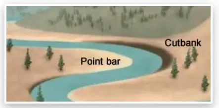
The image below shows a point bar and a cutbank of a meander. What happens to sediments at these locations?
Sediments are deposited on a point bar and on a cutbank.
Sediments are eroded from a point bar and from a cutbank.
Sediments are eroded from a point bar and deposited on a cutbank
Sediments are eroded from a cutbank and deposited on a point bar.
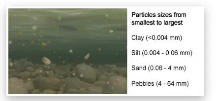
During a flood, a mountain river is carrying clay, silt, sand, and pebbles. The riverbed and particle sizes are shown below. Which sediments will most likely be deposited first when the river slows down?
Clay
Silt
Sand
Pebbles

A science team measured the discharge (amount of water flowing past a point each second) of Clear Creek during a storm. Their data table is shown
Based on the data, at which time would the creek cause the greatest amount of erosion, and why?
8:00 a.m., because the water is moving the slowest
12:00 p.m., because higher discharge increases the creek’s energy to erode sediment
2:00 p.m., because lower discharge carries smaller sediment particles farther downstream
Two satellite images show the mouth of a river taken 10 years apart.
In the first image, the river mouth is narrow and the coastline is straight.
In the second image, a wide triangular landform has formed at the river’s mouth, and the coastline extends farther into the ocean.
Which process most likely caused this change, and what evidence supports your answer?
Erosion increased, because the coastline is farther inland.
Wave action decreased, because fewer waves reached the shoreline.
Deposition increased, because sediment built up at the river’s mouth forming a delta.
A town is considering building new homes on a steep hillside. The soil is loose, the slope faces a river, and the area receives frequent heavy rainfall. The town council hires you to evaluate the risk.
Which recommendation best explains how the town can reduce the risk of destructive mass movement, and why?
Build drainage systems on the hillside, because removing excess water reduces the chance of a mudflow or slump.
Increase the slope angle, because steeper slopes allow water to run off faster.
Remove vegetation, because plants increase water moisture in the soil.
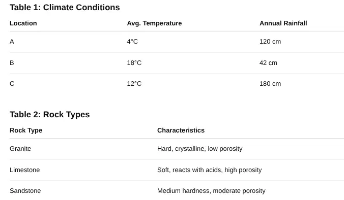
A science team is studying how rock type and climate affect weathering rates in three different locations. Use the data to answer the questions.
Observed Change After 5 Years
Location A: Granite shows small cracks; limestone shows moderate pitting
Location B: Limestone shows heavy chemical breakdown; sandstone shows minor rounding
Location C: Sandstone shows significant rounding; limestone shows deep fractures
Which location shows the fastest overall rate of weathering?
Location A
Location B
Location C
A science team is studying how rock type and climate affect weathering rates in three different locations. Use the data to answer the questions.
Observed Change After 5 Years
Location A: Granite shows small cracks; limestone shows moderate pitting
Location B: Limestone shows heavy chemical breakdown; sandstone shows minor rounding
Location C: Sandstone shows significant rounding; limestone shows deep fractures
Which location shows the fastest overall rate of weathering?
Location A
Location B
Location C
Select TWO pieces of evidence from the data that best support your answer in Part A.
Location C has the highest annual rainfall.
Limestone at Location C shows deep fractures.
Location A has the lowest temperature.
Sandstone at Location C has low porosity.
Granite at Location B shows no change.
Complete the statement to explain why the weathering rate is highest at this location.
High rainfall at Location C increases (a) , which causes the limestone and sandstone to break down more quickly.
Based on the weathering patterns observed at Location C, which changes are most likely to occur in the landscape over the next 50 years?
(Select TWO options.)
The region will develop new volcanic features.
Large amounts of new granite will form at the surface.
Slopes in the area will become smoother as rock material is removed.
More sediment will enter nearby streams as rocks continue to break down.
The landscape will become covered by glacial ice.

