
Font size
 Worksheets
Geographic Regions of China FT
Total questions: 32
Worksheet time: 20mins
Rohan is planning a trip to the Gobi Desert and wants to know what to expect. What is a key characteristic of the Gobi Desert?
It is covered in dense forests.
It has rocky terrain with very little vegetation.
It is located in southern China.
It is famous for its tropical climate.
Nora is planning a trip to explore the regions around the Tibetan Plateau. She wants to visit the Taklimakan Desert as part of her journey. Where is the Taklimakan Desert located in relation to the Tibetan Plateau?
South of the Tibetan Plateau
West of the Tibetan Plateau
Above (north of) the Tibetan Plateau
East of the Tibetan Plateau
Jackson is considering starting a farm on the Manchurian Plain. Why might this location not be ideal for farming?
It is too hot year-round.
It has short, cool summers.
It is covered in dense forests.
It is always flooded.
Scarlett is planning a hiking trip and wants to visit a place known for its high elevation. She is considering the Tibetan Plateau. Which of the following statements is TRUE about the Tibetan Plateau?
It is located in northern China.
Its elevation is about 13,000 feet.
It is covered in tropical rainforests.
It is famous for high-speed sandstorms.
Michael is planning a trip to the Gobi Desert and wants to visit its neighboring country. The Gobi Desert extends into which neighboring country?
India
Mongolia
Russia
Japan
Noah is studying the history of invasions in Asia for his school project. He comes across the Manchurian Plain and wonders which group historically used it as a route for their invasions. Can you help Noah identify the correct group?
Romans
Mongols
Vikings
Persians
Which region is great for livestock due to its prairie grass?
Tibetan Plateau
Manchurian Plain
Taklimakan Desert
North China Plain
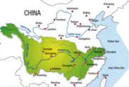
Zoe is preparing for her geography project and needs to present 5 facts about the Chang Jiang Basin or Yangtze River Basin. She also needs to locate it on the Map of China. Which of the following sets of facts should Zoe include in her presentation?
Warm wet rainforest climate, great for rice farming, located in the south-central part of China, features the Chang Jiang River which connects western and eastern China for transportation and trade.
Cold dry climate, great for wheat farming, located in the northern part of China, features the Yellow River which connects northern and southern China for transportation and trade.
Desert climate, great for cotton farming, located in the western part of China, features the Mekong River which connects China to Southeast Asia.
Mountain climate, great for tea farming, located in the eastern part of China, features the Pearl River which connects China to the Pacific Ocean.
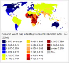
What is the rank of China in terms of size among countries?
China is the 3rd largest country.
China is the largest country.
China is the 2nd largest country.
China is the 10th largest country.
What is a dynasty?
A ruling family that passes power from one generation to the next.
A group of merchants trading goods.
A type of government with elected officials.
A period of peace and prosperity.
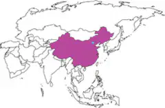
Which dynasty is believed to be the first in China?
The Xia Dynasty (c. 2100-1600 BC).
The Shang Dynasty (c. 1600-1050 BC).
The Han Dynasty (c. 206 BC-220 AD).
The Qin Dynasty (c. 221-206 BC).
What is one reason historians question the existence of the Xia Dynasty?
There are no written records from that time.
There were too many rulers at once.
The dynasty lasted only a few years.
The Xia Dynasty was located outside of China.
Was the Shang Dynasty known for advanced bronze casting?
Yes
No
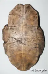
What is the significance of oracle bones in the Shang Dynasty?
They were used to ask questions about the future by interpreting cracks after heating.
They were used as currency for trade.
They were used as building materials for palaces.
They were used to record music and songs.

Emma is studying for her history test and wants to know which dynasty lasted longer than any other dynasty in Chinese history and introduced the Mandate of Heaven. Which dynasty should she choose?
Zhou Dynasty
Shang Dynasty
Qin Dynasty
Han Dynasty
What was the Mandate of Heaven introduced by the Zhou Dynasty?
The idea that a ruler could only stay in power if the gods approved.
The belief that rulers should be chosen by the people.
The law that only the eldest son could become king.
The tradition of building large palaces for the emperor.

Isla is planning a trip to countries that are south of China. Name two countries she could visit.
Russia and Mongolia
Vietnam and Laos
Nepal and India
Kyrgyzstan and Tajikistan
Olivia is planning a trip and wants to visit a country that is located north or northwest of China. Which of the following countries should she consider?
Kazakhstan
Thailand
India
Vietnam
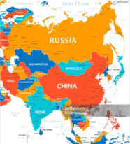
Based on the map, which country is NOT located north or northwest of China?
Mongolia
Russia
Kazakhstan
India

Mia is planning a trip and wants to travel northeast from China. Which country would she NOT reach?
Japan
South Korea
North Korea
Thailand
Which of the following is a major river in China?
Yangtze River
Amazon River
Nile River
Mississippi River
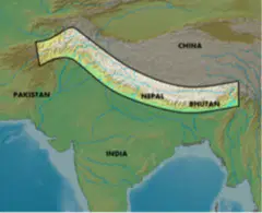
Which mountain range separates India from China and is known as the tallest in the world?
Himalayas
Andes
Alps
Rockies
Why might the Himalayas have played an important role in the history and development of China and India?
They acted as a natural barrier, influencing trade, climate, and cultural exchange.
They provided fertile land for farming.
They were a major source of oil.
They were the location of ancient cities.
Maya is planning to move to northern China or Mongolia for work. She researches the region and learns about the Gobi Desert. Explain how the location of the Gobi Desert could affect the climate and population distribution in the area Maya is considering.
The desert's dry conditions make the region less suitable for farming and dense population.
The desert provides abundant rainfall for agriculture.
The desert is a major source of freshwater.
The desert encourages the growth of forests.
What are the 5 major geographic regions of China?
Tibetan Plateau, Gobi Desert, Taklimakan Desert, Manchurian Plain, North China Plain, Chang Jiang Basin or Yangtze River Basin
Tibetan Plateau, Gobi Desert, Taklimakan Desert, Manchurian Plain, North China Plain, Amazon River Basin
Tibetan Plateau, Sonoran Desert, Taklimakan Desert, Manchurian Plain, North China Plain, Chang Jiang Basin or Yangtze River Basin
Himalayan Plateau, Gobi Desert, Taklimakan Desert, Manchurian Plain, North China Plain, Chang Jiang Basin or Yangtze River Basin
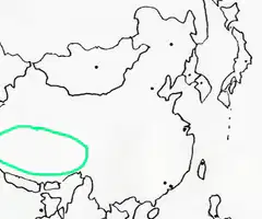
Of the 5 regions of China, which region is this?
Tibetan Plateau
Manchurian Plain
North China Plain
Yangtze River Basin
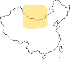
Of the 5 regions of China, which region is this?
Gobi Desert
Manchurian Plain
North China Plain
Yangtze River Basin

Of the 5 regions of China, which region is this?
Gobi Desert
Manchurian Plain
North China Plain
Yangtze River Basin
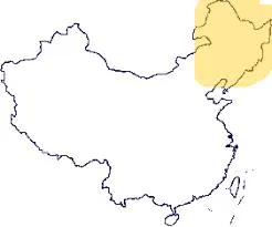
Of the 5 regions of China, which region is this?
Gobi Desert
Manchurian Plain
North China Plain
Yangtze River Basin

Of the 5 regions of China, which region is this?
Gobi Desert
Manchurian Plain
North China Plain
Yangtze River Basin
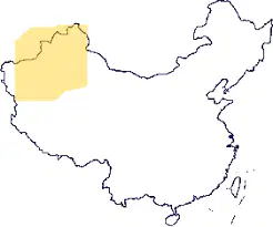
Of the 5 regions of China, which region is this?
Gobi Desert
Manchurian Plain
Taklimakan Desert
Yangtze River Basin
The Geography of China and Its Influence
China's geography has played a significant role in shaping its economy, culture, and military strategies. The country's vast network of rivers, such as the Yangtze and Yellow Rivers, has been essential for trade and transportation. These waterways have connected different regions, allowing goods and ideas to flow across the nation, boosting economic growth and cultural exchange.
Mountain ranges like the Himalayas and the Kunlun Mountains have served as natural barriers, protecting China from invasions throughout history. These rugged terrains have made it difficult for foreign armies to penetrate the country, providing a strong defense. At the same time, they have also isolated certain regions, influencing the development of unique local cultures.
China's diverse climate has had a profound impact on agriculture, which is a cornerstone of its economy. The fertile plains in the east are ideal for growing crops like rice and wheat, while the arid regions in the north are better suited for livestock farming. This variation in climate has led to a wide range of agricultural practices and food traditions across the country.
The rivers not only support trade but also provide water for irrigation, ensuring that crops can thrive even in challenging conditions. This has allowed China to sustain a large population and develop a strong agricultural base. The importance of these rivers in daily life and economic activities cannot be overstated.
Overall, China's geography has shaped its history and continues to influence its development today. From the rivers that drive trade to the mountains that offer protection, and the climate that supports agriculture, the country's natural features have been key to its success. Understanding this geography helps us appreciate the unique challenges and opportunities faced by China throughout its history.
Which rivers in China have been essential for trade and transportation?
Yangtze and Yellow Rivers
Amazon and Nile Rivers
Ganges and Brahmaputra Rivers
Mississippi and Missouri Rivers
What role have the Himalayas and Kunlun Mountains played in China's history?
They served as natural barriers protecting China from invasions.
They were used for large-scale farming.
They facilitated easy access for foreign armies.
They were the main source of China's rivers.
Which regions in China are ideal for growing crops like rice and wheat?
Fertile plains in the east
Arid regions in the north
Mountainous regions in the west
Desert areas in the south
How have China's rivers contributed to agriculture?
By providing water for irrigation
By serving as natural barriers
By isolating certain regions
By creating arid conditions
What is one major influence of China's diverse climate on its economy?
Development of varied agricultural practices
Creation of natural barriers
Isolation of certain regions
Facilitation of foreign invasions

