
NEW
Font size
 Worksheets
Honors Semester Final (A) 25'
Total questions: 75
Worksheet time: 38mins
All water areas of Earth are called:
Hydrosphere
Accretion
Water Cycle
Desalination
What creates many of Earth’s physical features through continental drift and magma flow?
Plate Tectonics
Erosion
Weathering
Atmosphere
Which longitude line runs North to South and splits the earth into East and West hemispheres, valued at 0 degrees and opposite the International Date Line?
Prime Meridian
Equator
Continental Shelf
Water Cycle
The chemical or physical processes that break down rocks into smaller pieces are called:
Weathering
Erosion
Accretion
Desalination
The thin layer of gases that surrounds Earth is the:
Atmosphere
Hydrosphere
Biosphere
Lithosphere
The process of removing salt from seawater is called:
Desalination
Erosion
Accretion
Weathering
A part of the coastal plain that extends out underneath the ocean is the:
Continental Shelf
Plate Tectonics
Water Cycle
Prime Meridian
When oceanic plates slide under continental plates and scrape off seamounts, leaving debris that causes the continents to grow outward, this is called:
Accretion
Erosion
Weathering
Desalination
The rotation of water from ocean to air to ground and back to the ocean is known as the:
Water Cycle
Plate Tectonics
Hydrosphere
Atmosphere
The movement of weathered rock by wind, glaciers, and moving water is called:
Erosion
Accretion
Weathering
Desalination
A region defined by ONE unifying characteristic or prominent feature is a:
Formal Region
Prime Meridian
Plate Tectonics
Water Cycle
Maps that show population density are physical maps.
True
False
A disadvantage of the Winkel Tripel projection is that it doesn’t accurately show distances, sizes, and geographic shapes.
True
False
To use remote sensing correctly, a geographer needs to be physically at the place of study.
True
False
The biosphere cannot exist without interaction with the atmosphere and hydrosphere.
True
False
Planets, moons, and stars revolve around the sun, but asteroids and meteoroids do not.
True
False
The Northern Hemisphere experiences summer when it is tilted towards the sun and receives more direct sunlight.
True
False
The Equator experiences the most dramatic variation in the amount of sunlight.
True
False
Geographers and historians study cultural hearths because they are the centers where the world’s first civilization arose.
True
False
Trade, migration, and war are all factors that encourage cultural change.
True
False
In the grid system used to map locations on Earth’s surface, lines parallel to the Equator and run east to west are known as:
Latitudinal lines.
Geometric lines.
Barometric lines.
Longitudinal lines.
Grid lines
The three major ways the round Earth is presented on a flat map include ________ projections.
Geometric, longitudinal, and latitudinal
Directional, Spatial, and Spherical
Planar, Conic, and Cylindrical
Regional, Topographic, Relief
Political, Physical, Thematic
A way of looking at the human and physical patterns on Earth and their relationships to one another
Geospatial perspective
Geometric perspective
Geologic perspective
Global perspective
Objective perspective
The shortest path between two places on a globe
Formal Regions
Relative location
Great Circle Route
Planar Projection
GPS
What is the scale on a map used for?
Distance between objects or places on a map
Distance between landmasses and water on a map
Distance between latitude and longitude lines on a map
Distance on a map in relation to actual distance on Earth
It measure the weight of countries
What is the name given to people who make maps?
Cartographers
Meteorologist
Anthropologist
Geographer
Professional Mapper
What are the 5 parts of a map?
Planar, Circle, Cylinder, Conic
Key, Grid, Scale, Title, Compass
Jupiter, Saturn, Uranus, Neptune, and Pluto
Key, Grid, Latitude, Longitude, Title
Continents, Oceans, Grid lines, States, Borders
Why would a geographer think understanding our solar system is important?
to track asteroids and comets so they don’t collide with Earth
to map the positions and orbits
to understand how Earth fits into this system, much as how different areas of Earth fit together
to determine which planets may have supported life in the past or be able to sustain life now
to learn all the astronomy and astrology in the universe
Of Earth’s three structural layers, the hottest is:
the core, which includes a solid inner core and liquid outer core.
the crust, which is heated by solar radiation.
the atmosphere, which experiences hot summer weather.
the mantle, which contains the magma that makes volcanoes.
the lithosphere, which contains all magma
The sun activates the water cycle by:
Condensing water in lakes and rivers
Causing weather systems to occur
Evaporating water from the surfaces of bodies of water
Causing precipitation
Making the ocean warm
What is Weather?
Condition of the atmosphere in one place during a short period of time
Condition of the atmosphere in one place during a long period of time
The breakup of rock over a long period of time
Thunderstorms
The chemical and physical effect of the atmosphere
This is known as a phenomenon that causes dry areas to develop on the leeward side of mountain ranges.
Rain-shadow effect
Coriolis effect
Greenhouse effect
El Nino
Mandela effect
This is defined as a regional ecosystem with distinct plants and animals
Biome
Habitat
Biosphere
Community
Population
When it is winter in the Northern Hemisphere, what season is it in the Southern Hemisphere?
Spring
Winter
Autumn
Summer
How frequently does Earth complete one rotation on its axis?
Every 60 minutes
Every 24 hours
Every 7 days
Every 365 days
Every month
Which area experiences the midnight sun?
The Equator
The Arctic
The Mid-Latitude Zones
The Horse-Latitude Zones
The Doldrums
Different places on Earth receive different amounts of direct sunlight at the same time. Why?
Because volcanic eruptions cloud the sky.
Because of climate variations.
Because the greenhouse effect blocks the sun’s rays.
Because earth is tilted on its axis.
Because of the weather variations.
What is the term for the generally windless area near the Equator?
The prime meridian
The doldrums
The horse latitudes
The mid-latitudes
Prevailing winds
__________ is the spread of cultural traits, both material and non-material, from one culture to another.
Cultural dispersion
Cultural dissonance
Cultural diffusion
Cultural assimilation
Cultural awareness
A sovereign head of state, especially a king, queen, or emperor.
Monarchy
Oligarchy
Democracy
Theocracy
Dictator
A state in which supreme power is held by the people and their elected representatives
Allies
Republic
Autocracy
Anarchy
Oligarchy
A type of government that is ruled by the people.
Oligarchy
Dictatorship
Democracy
Monarchy
Communist
A ________ boundary often follows straight lines and does not account for physical features.
Cultural
Ethnic
Geometric
Natural
Political
Which Caribbean island nation was the site of a successful slave revolt in 1804?
Cuba
Jamaica
Haiti
Puerto Rico
Trinidad and Tobago
Which of the following best describes the purpose of the Panama Canal?
To connect North and South America
To provide drinking water for Panama
To allow faster shipping between the Atlantic and Pacific Oceans
To eliminate the need for air travel
What is the economic system of the United States primarily based on?
Socialism
Communism
Free enterprise capitalism
Monarchy
What physical feature forms part of the U.S.–Mexico border?
The Mississippi River
The Rio Grande River
The Colorado Plateau
The Sierra Nevada
Why were the first factories in the United States located along the fall line in the Northeast?
Access to ocean shipping routes
The rivers provided power for manufacturing
Abundant coal deposits
Access to skilled labor
What is the term for a narrow land bridge that connects two larger land areas?
Peninsula
Strait
Archipelago
Isthmus
What is a minifundia?
A large cattle ranch
A government-built housing area
A small farm for family use
A type of eco-lodge
Which major mountain range runs through western Mexico?
Andes
Rockies
Sierra Nevada
Sierra Madre Occidental
What are maquiladoras?
Tourist resorts in the Caribbean
State-run farms in Mexico
Manufacturing plants in Mexico, often near the U.S. border
Mountain towns known for eco-tourism
Which Central American country is known for being a land bridge between North and South America?
Nicaragua
Honduras
Panama
Guatemala
El Salvador
Mexico is the world’s leading producer of which precious metal?
Gold
Silver
Lead
Copper
Zinc
What is the tallest peak in the United States? It’s located in Alaska.
Mt. Appalachian
Mt. Denali
Alaskan Range
Mt. Rainier
Mt. St. Elias
Why did shipbuilding become a major industry in the New England Colonies?
Mild winters made construction easy
There was limited trade in other regions
The area had many harbors and forests for timber
Fishing was not popular in the South
Cotton production supported naval transport
What caused many Americans to move to cities during the late 1800s?
Decline in immigration
The invention of dry farming
The Industrial Revolution
The Homestead Act
Railroads were dismantled
Most of Central America was colonized by:
The Netherlands
France
Spain
Great Britain
The United States
What is an archipelago?
A chain of mountains
A narrow strip of land between two seas
A group or chain of islands
A valley surrounded by cliffs
A flat area between two rivers
Greater numbers of plant and animal species in an ecosystem indicate higher:
Productivity
Fertility
Biodiversity
Altitude
Rainfall
Which Mexican muralist became famous for large works depicting culture, struggle, and history?
Diego Lopez
Diego Rivera
Mario Martinez
Diego Hernández
Jose Posada
Where were the ancient Maya primarily located?
The Mexican Plateau
The Southern Highlands
The Baja Peninsula
The Yucatán Peninsula
Central Mexico City
What is the largest natural lake in Mexico?
Lake Texcoco
Lake Quechelac
Lake Catemaco
Lake Chapala
Lake Veracruz

Which city and state are located at 33°N latitude, 112°W longitude?
Denver, Colorado
Lincoln, Nebraska
Phoenix, Arizona
Portland, Oregon
Miami, Florida
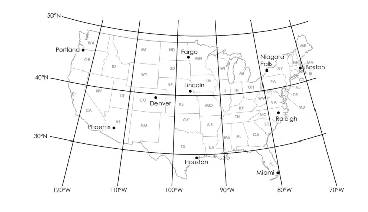
Which city and state are located at 43°N latitude, 79°W longitude?
Niagara Falls, New York
Phoenix, Arizona
Houston, Texas
Fargo, North Dakota
Denver, Colorado
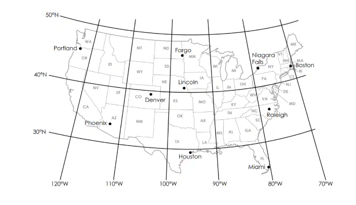
Which city and state are located at 25°N latitude, 80°W longitude?
Denver, Colorado
Portland, Oregon
Raleigh, North Carolina
Phoenix, Arizona
Miami, Florida
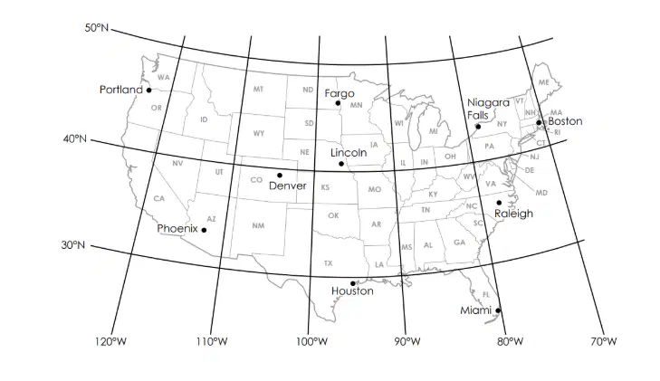
Which city and state are located at 35°N latitude, 78°W longitude?
Denver, Colorado
Houston, Texas
Fargo, North Dakota
Niagara Falls, New York
Raleigh, North Carolina
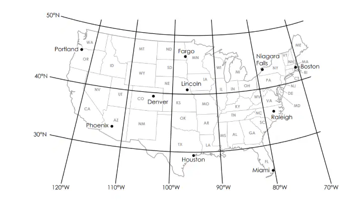
Which city and state are located at 45°N latitude, 122°W longitude?
Denver, Colorado
Houston, Texas
Fargo, North Dakota
Portland, Oregon
Raleigh, North Carolina
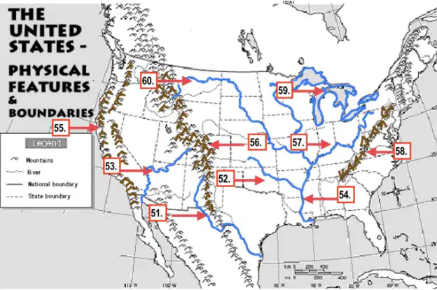
Which river is this? # 54
The Rio Grande River
Mississippi River
Missouri River
Ohio River
Arkansas River
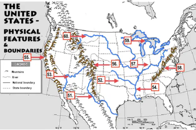
Which River is this? #60
The Colorado River
Mississippi River
Missouri River
Ohio River
Arkansas River
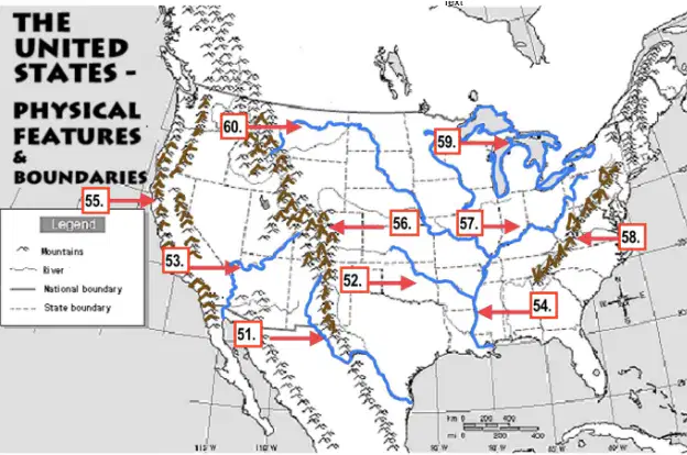
Name this Mountain Range (#56)
The Appalachian Mountains
The Rocky Mountains
The Pacific Mountain Range
Mt. McKinley
The Green Mountain Range
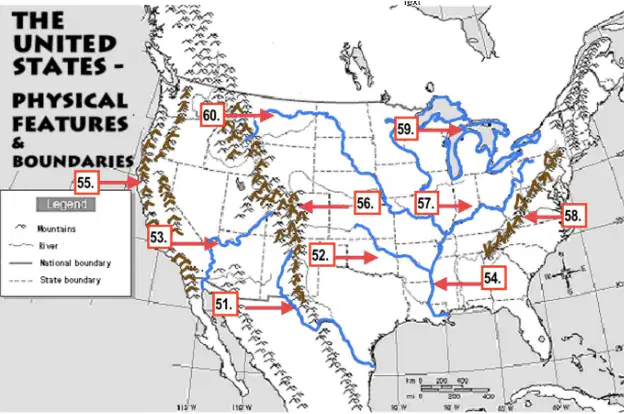
Name this River (#53)
The Colorado River
The Mississippi River
Ohio river
Arkansas River
The Missouri River

Name this River (#52)
The Colorado River
Mississippi River
Missouri River
Ohio River
Arkansas River

What is the name of these lakes? (#59)
Belton Lake
The Big Lakes
The Great Lakes
The Michigan Lakes
The Deep Lakes
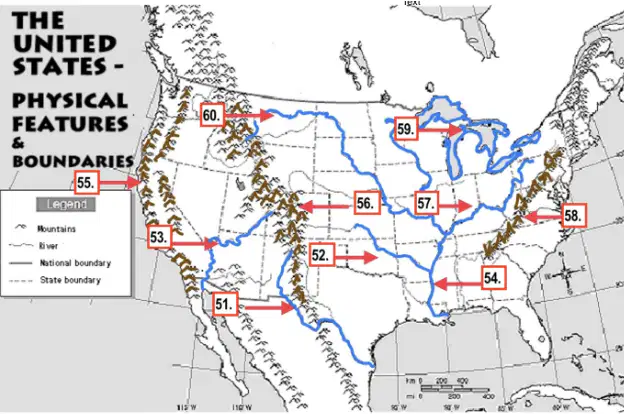
Name this River (#57):
The Colorado River
The Mississippi River
The Ohio River
The Missouri River
The Arkansas River

