wayground logo

Free Printable Worksheets

Font size

S
M
L
XL
Worksheets

2026 Political and Urban Geography Test Recovery

Total questions: 80

Worksheet time: 40mins

Name
Class
Date
1.
Which of the following are urban centers that thrived because of their situation near the overland trade route on the map? Choose all that apply.
a)
Samarkland, Uzbekistan
b)
Xi'an China
c)
Timbuktu, Mali
d)
Istanbul, Turkey
e)
Capetown, South Africa
2.
Older part of the city, often characterized by lower-income and over-crowded neighborhoods -
a)
Central Business District
b)
Inner City
c)
Suburb
d)
Exurb
3.
City with a population of more than 10 million people
a)
megalopolis
b)
metropolitan area
c)
megacity
d)
metropolis
4.
When discussing urban geography, SITE would best be defined as-
a)
the relative location of a city
b)
the latitude belt in which a city is located
c)
the type of architecture found in a city
d)
the physical location of a city
5.
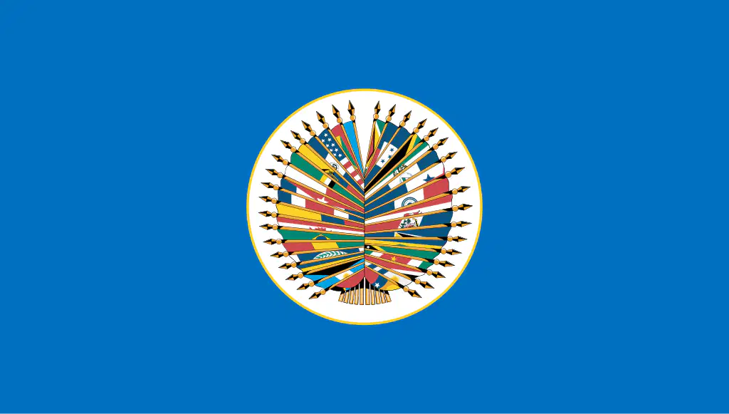
The cooperative alliance represented by the symbol below would most likely be interested in-
a)
establishing a common currency across Western European countries
b)
aiding countries around the world in times of crisis
c)
creating a military alliance against the spread of communism
d)
expanding free trade in the Southeast Asia region
6.
Which of the following urban centers is NOT a hilltop site?
a)
Baghdad
b)
Jerusalem
c)
Athens
d)
Rome
7.
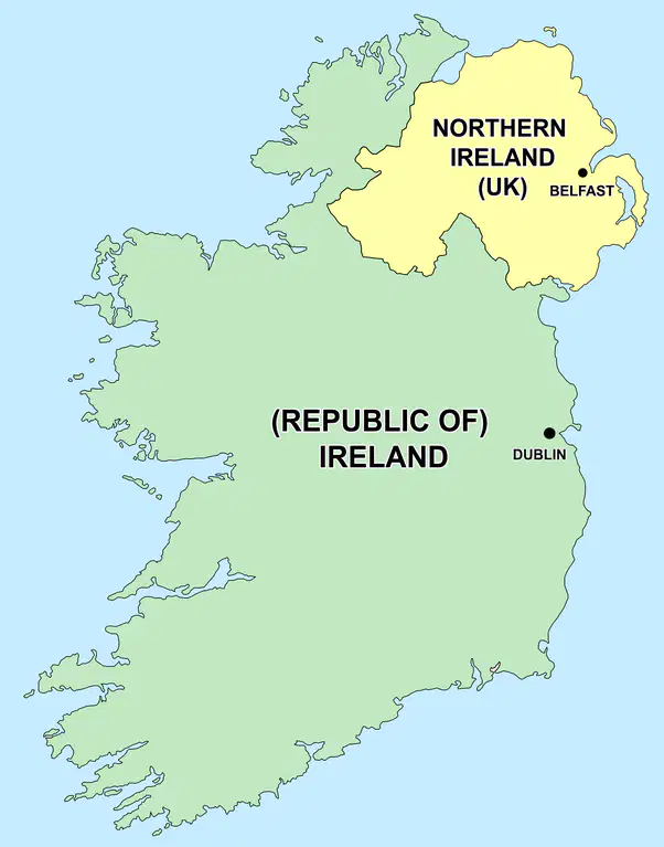
Which of the following statements best describes the conflict that has taken place at the location depicted on the map below?
a)
The Muslims of Northern Ireland want independence from the Hindus of The Republic of Ireland.
b)
The Catholics of The Republic of Ireland want to join the United Kingdom.
c)
Northern Ireland is divided between Catholics who want to join with the Republic of Ireland and Protestants who are loyal to the UK.
d)
The Republic of Ireland has experienced violence between its Serbian and Bosnian population.
8.
Which of the following cities is situated on the strait shown in the map below that connects the Mediterranean and Black Seas between Asia and Europe?
a)
Baghdad
b)
Istanbul
c)
Singapore
d)
Vladivostok
9.
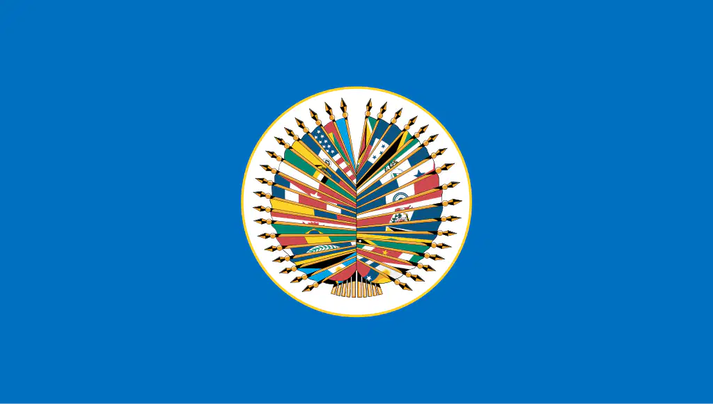
The map below highlights the members states of which alliance?
a)
North Atlantic Treaty Organization
b)
European Union
c)
Organization of American States
d)
Commonwealth of Nations
10.
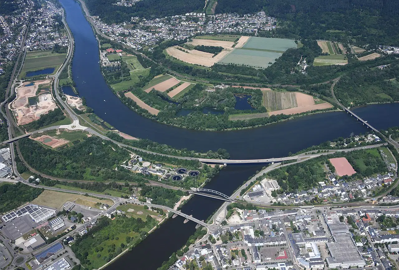
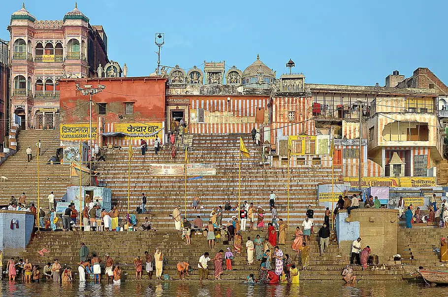
Select the cities from the list that are loacted on a site like the one in the photograph.
a)
Pittsburgh
b)
Khartoum
c)
Paris
d)
Istanbul
e)
Timbuktu
11.
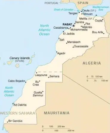
Which of the following best describes the conflict between Western Sahara and Morocco?
a)
It is a religious conflict between Shi'a Muslims in Western Sahara and Sunni Muslims in Morocco.
b)
It is a dispute over the independence of Western Sahara. Morocco claims the region and its valuable resources.
c)
It is an ethnic conflict between the Hutu tribe of Western Sahara and the Tutsi of Morocco that has led violence.
d)
It is a territorial dispute over the Golan Heights, a section of land taken from Morocco by Western Sahara.
12.
Which city's situation on the southern coast of this continent has allowed it to become a supply station for ships?
a)
Cape Town
b)
Richmond
c)
Alexandria
d)
Khartoum
e)
Damascus
13.
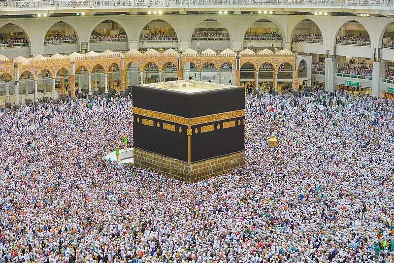
Identify the city situated near the pilgrimage site in the picture below and the religion whose followers consider the location sacred.
a)
Jerusalem, Islam
b)
Mecca, Islam
c)
Jerusalem, Judaism
d)
Mecca, Hinduism
14.
In which of the following cities would you be most likely to eat at a restaurant called "The Trans-Saharan Café?"
a)
Samarkand, Uzbekistan
b)
Xian, China
c)
Novosibirsk, Russia
d)
Timbuktu, Mali
15.
Which economic alliance would have had an effect on the data in the graph below after 1960?
a)
OPEC
b)
OAS
c)
ASEAN
d)
NATO
16.
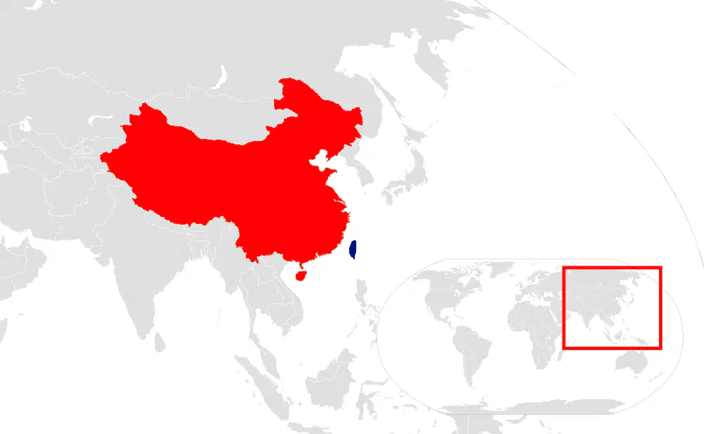
Which of the following statements best describes the conflict between the locations in red and in blue on the map?
a)
There is a cultural conflict between Buddhists and Confucianists.
b)
There is a economic conflict over access to the fertile farmland on the island.
c)
There is a territorial dispute over the independence of the island between China and Taiwan.
d)
There is an ethnic conflict between the Hutu majority on the continent and the Tutsi minority on the island.
17.
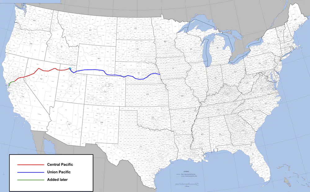
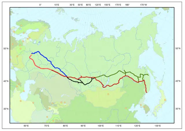
Select the cities which benefitted from their situation along the railroad shown on the map below.
a)
Omaha
b)
Sacramento
c)
Novosibirsk
d)
Vladivostock
e)
Pittsburgh
18.
All of the following city sites are on harbors except-
a)
Paris
b)
New York
c)
Istanbul
d)
Alexandria
19.
Which of the following best describes the cultural differences highlighted on the map below?
a)
There is conflict between Arab Muslims and African Christians and Animists.
b)
This map shows a country with many ethnic groups, languages and religions. There are tensions between Sunni, and Shi'a Muslims, Christians and people of Western Papua.
c)
The highlighted province of this country speaks French while the rest of the country speaks English.
d)
The population of this country is divided between Catholic Christians and Protestant Christians in the highlighted province.
20.
Which of the following would NOT be considered an explanation for why political divisions at the national and international level exist?
a)
Natural disasters force nations to pursue their own interests.
b)
Differences in culture, language and religion
c)
Imperial conquest and control of colonial lands by other countries
d)
Desire to retain historical boundaries
e)
Economic similarities and differences - e.g. capitalism vs. command
21.
Which of the following best describes the territorial dispute in the region shown on the map below?
a)
Kashmir is a disputed territory between Israel and Syria.
b)
Morocco wants to take Western Sahara because of its valuable natural resources.
c)
Taiwan's independence is not recognized by China.
d)
India and Pakistan both claim Kashmir. Kashmir is divided between Muslims loyal to Pakistan and Hindus loyal to India.
22.
Which political and cultural alliance is represented by this map?
a)
African Union
b)
European Union
c)
North Atlantic Treaty Organization
d)
League of Arab States
e)
Association of Southeast Asian Nations
23.
Which of the following best describes the definition of "situation" as it relates to urban geography?
a)
The relative location of a city with respect to other geographic features, regions, resources, and transport routes.
b)
The absolute location of a city in terms of its latitude and longitude
c)
The actual location of a city in terms of its physical geography
d)
The way a city relates to the other cities in the region economically through trade and alliances
24.
Select the cities from the list below that are located on a site like the one shown in the picture.
a)
Hong Kong
b)
Paris
c)
Singapore
d)
Istanbul
e)
Khartoum
25.
Choose two cities from the list that are situated on the railway shown on this map.
a)
Vladivostok
b)
Novosibirsk
c)
Sacramento
d)
Timbuktu
e)
Singapore
26.
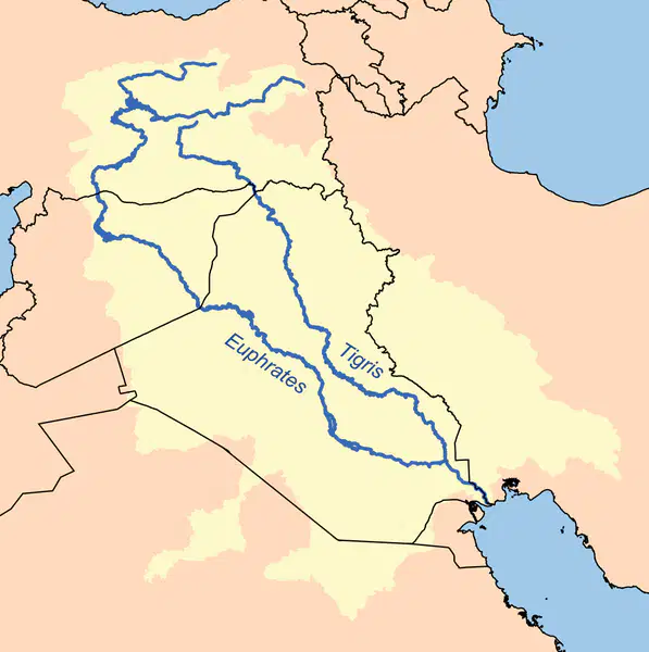
Choose the city situated between the rivers shown on the map below.
a)
Damascus
b)
Varanasi
c)
Mecca
d)
Alexandria
e)
Baghdad
27.
Pittsburgh, Pennsylvania owes its growth and prosperity to the -
a)
aircraft industry
b)
clothing industry
c)
steel industry
d)
computer industry
28.
Which phrase would make the best title of this list? * Security and defense * Religious centers * Government administration
a)
Urban Areas
b)
Free Trade Regions
c)
Integrated Neighborhoods
d)
Regional Conservation Offices
29.
Which city most likely serves as an international trade center?
a)
Pittsburgh, Pennsylvania
b)
Brasilia, Brazil
c)
Mecca, Saudi Arabia
d)
New York City, New York
30.
This ancient city has played an important role in the surrounding region for thousands of years because of its site on an oasis.
a)
Alexandria, Egypt
b)
Damascus, Syria
c)
Istanbul, Turkey
d)
Baghdad, Iraq
e)
Varanasi, India
31.
Choose the two cities from the list that are situated where a river narrows.
a)
Quebec City
b)
London
c)
Istanbul
d)
Omaha
e)
Khartoum
32.
Richmond, Virginia is a city on the site -
a)
of a confluence
b)
of a mountain pass
c)
of a fall line
d)
of a fortified hill
33.
As the capital of the United States, which function of cites is best served by Washington D.C.?
a)
religious center
b)
security and defense
c)
manufacturing and service
d)
seat of government administration
e)
center for local and long distance trade
34.
Which of the following is NOT a problem associated with the growth of cities and urban areas?
a)
It is difficult to provide utility services for the growing population.
b)
The wealthy and poor inhabitants of the city work together to solve problems.
c)
Increased air, water and noise pollution
d)
Urban sprawl results in the conversion of farmland to suburbs.
e)
It is difficult to provide enough schools for the population.
35.
From the list, choose all the ways urban areas (cites) influence the regions around their location.
a)
Cities contain monuments that create feelings of nationalism.
b)
New ideas and advances in technology often originate in cities.
c)
Cities do not often attract migrants or accept diverse cultural traits.
d)
Universities and centers of learning are found in cities.
e)
Television and radio stations and other media centers are located in cities.
36.
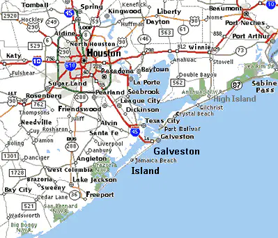
Which role of urban centers is best illustrated by the map of Houston Texas?
a)
magnet for migration
b)
media center
c)
transportation hub
d)
technology seed bed
e)
communication hub
37.
Select the city that is situated by a pilgrimage site on the Ganges River in India. Also, identify the religious tradition that considers it sacred.
a)
Varanasi, Hinduism
b)
Jerusalem, Judaism
c)
Mecca, Islam
d)
Jerusalem, Islam
e)
Varanasi, Christianity
38.
Which of the following Balkan ethnic groups suffered tensions following the collapse of communism in Eastern Europe?
a)
Albanians
b)
Bosnians
c)
Croats
d)
Serbs
e)
Bostonians
39.
The dispute between Syria and Israel dates back to the -
a)
occupation of the Golan Heights after the "Six Day War."
b)
the dropping of the "Iron Curtain."
c)
the discovery of phosphate mines and maritime oil.
d)
the division of land following the demise of the British Empire.
40.
Choose the alliance from the list that fits the description. A political and military alliance of countries from North America and Europe that supports democracy and security for its members.
a)
NAFTA
b)
NATO
c)
UN
d)
AU
e)
OAS
41.
Choose the alliance from the list that fits the description. A political organization created in 1945 and made up of over 190 countries that works for international peace.
a)
EU
b)
AU
c)
UN
d)
OAS
e)
NAFTA
42.
Which international economic organization has the primary function of monitoring and stabilizing the global system of currencies and international payments, often providing short-term loans to countries facing financial crises?
a)
World Trade Organization (WTO)
b)
International Monetary Fund (IMF)
c)
Organization of Petroleum Exporting Countries (OPEC)
d)
United States, Mexica, Canada Agreement (USMCA)
43.
Following a prolonged civil war in a region, millions of people fled their homes, becoming refugees, and the lack of clean water led to the spread of disease. A global superpower then imposed sanctions, causing the price of oil worldwide to increase sharply. This scenario primarily demonstrates the analysis of:
a)
The initial political causes of the conflict
b)
The role of geographic boundaries in the war's outcome
c)
The long-term economic and humanitarian impacts of the conflict
d)
A comparison of military tactics used by opposing forces
44.
Choose the alliance from the list that fits the description. A political organization made up of countries from the Western Hemisphere that works for democracy, human rights and against drug trafficing.
a)
Red Cross
b)
ASEAN
c)
AU
d)
EU
e)
OAS
45.
All of the following city sites are on harbors except-
a)
Khartoum
b)
Boston
c)
Istanbul
d)
New York
e)
San Francisco
46.
Choose countries associated with the alliance from the list that fits the description: A political organization made up of countries from the Western Hemisphere that works for democracy, human rights and against drug trafficking.
a)
U.S.
b)
Argentina
c)
Colombia
d)
Belize
e)
Brazil
47.
The Golan Heights, in the Northeastern region of the map below, has been a longstanding region of conflict between which of the two countries from the list?
a)
India and Pakistan
b)
China and Taiwan
c)
Israel and Syria
d)
Western Sahara and Morocco
48.
The island highlighted in the map is the location for ethnic conflict between which two groups?
a)
Hutu and Tutsi
b)
Serbs and Bosnians
c)
Indonesians and Papuans
d)
Greeks and Turks
49.

Which city is known for its strategic location at the mouth of the Bosporus Strait, serving as a bridge between Europe and Asia?

a)

Paris

b)

Damascus

c)

Alexandria

d)

Istanbul

50.

Which of the following is a major challenge faced by rapidly growing urban areas?

a)

Increased pressure on infrastructure and resources

b)

Reduction in pollution levels

c)

Decreased demand for housing

d)

Improved access to public transportation

51.

Which international organization is primarily focused on promoting economic cooperation and development among its member countries in Southeast Asia?

a)

OPEC

b)

EU

c)

NATO

d)

ASEAN

52.

Which city is famous for being a crossroads of three continents and has historically served as a gateway between Europe and Asia?

a)

Rome

b)

Istanbul

c)

San Francisco

d)

Athens

53.

Which of the following alliances is primarily focused on economic cooperation among oil-exporting countries?

a)

ASEAN

b)

EU

c)

NATO

d)

OPEC

54.

Which city is renowned for its location on a major river confluence, contributing to its historical significance as a trade center?

a)

Mecca

b)

Baghdad

c)

San Francisco

d)

Khartoum

55.

Which of the following is NOT a typical challenge faced by rapidly growing urban areas?

a)

Strain on transportation systems

b)

Improved air quality

c)

Increased demand for housing

d)

Pressure on public services

56.

What does landlocked mean?

a)

Having a common culture

b)

Having no outlet to the sea

c)

Holding complete political power

d)

Being a commercial core of the city.

57.

What is a suburb?

a)

A political unit with no outlet to the sea

b)

A unit touching the central city or other suburbs

c)

A rise in the number of cities

d)

The commercial core of the city.

58.

The central business district (CBD) is ______.

a)

a political unit with no outlet to the sea

b)

the commercial core of the city

c)

a rise in the number of cities

d)

a study of how people use space in cities.

59.

As in the picture above, most people living in undeveloped countries engage in _________.

a)

Sedentary agriculture

b)

Subsistence agriculture

c)

Shifting agriculture

d)

Commercial agriculture

60.

The excerpt above describes a political system that would be best identified as-

a)

Theocracy

b)

Constitutional Monarchy

c)

Democracy

d)

Dictatorship

61.

Why are many cities located near bodies of water?

a)

for protection from known enemies

b)

it allows for good transportation

c)

to keep people from wanting to travel there

62.

What is the main function of the darker-shaded region on this map?

a)

Business development

b)

Resource protection

c)

Tourist attraction

d)

Waste disposal

63.

Which level of government would most likely be responsible for waste disposal in a neighborhood?

a)

State

b)

National

c)

International

d)

County

64.

Which of the following is NOT a regional issue?

a)

International trade

b)

Magnet schools

c)

Transportation

d)

Waste management

65.

Which of the following is NOT a reason for political divisions?

a)

Desire for government closer to home

b)

Taxation purposes

c)

Need to administer resources more efficiently

d)

Need to solve local problems

66.

What is an advantage to building a city at a confluence site?

a)

Increased access to trade routes

b)

Reduced risk of natural disasters

c)

Decreased regional conflicts

d)

Improved technological innovations

67.

Which of the following is NOT a function of a town or a city?

a)

Farming centers

b)

Trade centers

c)

Religious centers

d)

Governmental administration

68.

Which of the following best completes the graphic?

a)

Natural disasters destroying economies

b)

Depletion of vital resources

c)

Depletion of workers in the mines

d)

Cultural differences among residents

69.

In South America, a capital was moved so that improvements could be made to the entire nation. What country moved its capital?

a)

Chile

b)

Brazil

c)

Argentina

d)

Venezuela

70.

How do these monuments in Washington, D.C. most likely influence nation-building in the United States?

a)

They are communication hubs for the United States

b)

They encourage people to migrate to the United States

c)

They are symbols of national pride

d)

They lead to creativity in the arts

71.

Which of the following is NOT an essential service that urban areas provide?

a)

Electricity

b)

Clinics

c)

Sewage

d)

Entertainment

72.

Which of the following is NOT a way urban centers influence regions and countries?

a)

Magnets for migration

b)

Media Centers

c)

Lack of diverstiy

d)

Transportation/Communication hubs

73.

What is the best title for the graphic?

a)

Influences of Urban Areas on Their Regions and Countries

b)

Examples of Cooperation

c)

Examples of Changes in Cities' Functions Over Time

d)

Problems Associated with Growth of Urban Areas

74.

List the five republics that composed the country formerly known as Yugoslavia.

a)

Bosnia & Herzegovina, Croatia, Macedonia, Serbia-Montenegro, Slovenia

b)

Bosnia & Herzegovina, Croatia, Montenegro, Serbia, Slovakia

c)

Bosnia & Herzegovina, Croatia, Kazakhstan, Serbia, Slovenia

d)

Bulgaria, Croatia, Macedonia, Serbia, Slovenia

75.

Noah is planning a trip to learn about different cultures and wants to visit the ethnic region of Kurdistan. In which countries should Noah plan to travel?

a)

Turkey, Iraq, Iran, Syria

b)

France, Germany, Italy

c)

Brazil, Argentina, Chile

d)

China, Japan, South Korea

76.

Why did most cities develop near water?

a)

Water is necessary to support life (drink, farm, etc.) and water is needed for the efficient and expedient transportation of goods

b)

Cities near water have better weather all year round

c)

Water sources are always free from pollution

d)

Cities near water are always safer from natural disasters

77.

The growth of cities such as Samarkand and Xi’an was allowed by:

a)

the development of major trade routes

b)

the construction of large religious temples

c)

the discovery of new agricultural techniques

d)

the establishment of local monarchies

78.

37. What allowed Timbuktu to grow?

a)

Its location on important trade routes

b)

Its advanced military technology

c)

Its large population from the start

d)

Its abundant natural resources

79.

Novosibirsk, Russia grew even though it is seemingly in the middle of nowhere because:

a)

it was a major stop on the Trans-Siberian Railway.

b)

it is located near the Arctic Circle.

c)

it has a large natural harbor.

d)

it was founded as a military outpost.

80.

Urban sprawl refers to:

a)

the uncontrolled expansion of urban areas into surrounding regions

b)

the preservation of green spaces within cities

c)

the development of high-density housing in city centers

d)

the reduction of city population through migration