
Earth Science Maps Presentations
This presentation provides structured instruction on Earth Science Maps, using visual learning and lesson slides to explain key concepts in cartography and geological mapping. Students will explore how scientists use various types of maps to represent Earth's features, processes, and data through comprehensive visual materials.

11 questions
Maps for Science
Presentation
•
6th - 8th Grade

19 questions
Earth Science
Presentation
•
8th Grade
20 questions
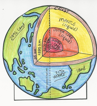
Earth's Layers
Presentation
•
7th - 8th Grade

15 questions
Structures of the Earth
Presentation
•
8th Grade

19 questions
Earth's History Lecture
Presentation
•
6th - 8th Grade

22 questions
Earthquakes and Earth's Layers
Presentation
•
8th Grade
20 questions
Weather Fronts and Maps
Presentation
•
8th Grade
20 questions
Maps and Computers
Presentation
•
8th Grade
34 questions
Air Mass/Fronts/Maps
Presentation
•
8th Grade
Browse by grade
Explore Earth Science Maps Presentations
Earth Science Maps presentations available through Wayground (formerly Quizizz) provide comprehensive concept explanation and visual learning opportunities that help students master the interpretation and analysis of geological, topographical, and atmospheric mapping systems. These structured instructional resources develop critical spatial reasoning skills while teaching students to read contour lines, identify geological formations, analyze weather patterns, and understand the relationships between physical features and their representation on various map types. The presentations emphasize visual learning through detailed diagrams, cross-sectional views, and interactive map examples that make abstract cartographic concepts accessible to learners at different skill levels. Wayground (formerly Quizizz) supports teachers with millions of teacher-created Earth Science Maps presentations that can be easily discovered through robust search and filtering capabilities, allowing educators to find resources aligned with specific curriculum standards and learning objectives. The platform's differentiation and customization tools enable teachers to modify presentations for diverse learning needs, adjusting complexity levels and adding supplementary content to support both struggling students and advanced learners. These digital-first resources offer flexible delivery formats suitable for whole-class instruction, small group work, or independent study, making them valuable for lesson planning, concept remediation, skill reinforcement, and enrichment activities that deepen students' understanding of cartographic principles and geographic analysis techniques.
Accessibility
Features
Wayground Super
School & District
Wayground for Business
Create a quiz
Create a presentation
Wayground AI
Subjects
Mathematics
Social Studies
Science
Physics
Chemistry
Biology
About
Our Story
Wayground Blog
Media Kit
Careers
Support
F.A.Q.
Help & Support
Privacy Policy
Terms of Service
Teacher Resources
2026 Wayground


Get our app

