

Map Scale Quizzes
Test your understanding of map scale concepts and practice calculating distances using different scale representations. This self-paced assessment provides instant feedback to help you master the relationship between map measurements and real-world distances.
10 questions
Map Scales - Word Scales

Quiz
•
4th - 7th Grade

8 questions
Map Key & Map Scale
Quiz
•
5th Grade

10 questions
Location/Direction and Map Scale/Symbols TCI
Quiz
•
4th Grade

11 questions
All About Maps
Quiz
•
7th Grade

23 questions
Map Reading
Quiz
•
7th Grade

23 questions
Map Skills
Quiz
•
4th Grade
10 questions
Map Skills
Quiz
•
4th Grade
25 questions
Maps and Map Features
Quiz
•
6th Grade
20 questions
Map Skills
Quiz
•
4th - 6th Grade
13 questions
Parts of a Map
Quiz
•
5th - 7th Grade
16 questions
Guide to Understanding Maps
Quiz
•
3rd - 5th Grade
Explore Map Scale Quizzes
Map scale concepts form the foundation of spatial reasoning and geographic literacy, requiring students to understand the relationship between distances on maps and corresponding real-world measurements. These comprehensive quiz collections through Wayground provide targeted assessment opportunities that help students master ratio calculations, scale interpretation, and distance measurement skills essential for geographic analysis. The practice questions systematically build understanding of representative fractions, graphic scales, and verbal scales while offering immediate feedback that reinforces learning and identifies areas requiring additional support. Students develop critical thinking abilities as they work through problems involving scale conversion, map reading accuracy, and spatial proportional reasoning that connects mathematical concepts with geographic applications. Wayground supports geography educators with access to millions of teacher-created quiz resources specifically designed to address map scale instruction across diverse learning environments. The platform's robust search and filtering capabilities enable teachers to locate materials aligned with curriculum standards while offering extensive customization tools for differentiating instruction based on individual student needs. These digital-first quiz formats provide flexible delivery options that accommodate various classroom structures, from independent practice sessions to collaborative learning activities. Teachers can effectively plan progressive skill-building sequences, identify students requiring remediation through detailed performance analytics, and provide enrichment opportunities for advanced learners, ensuring comprehensive map scale competency development that supports broader geographic understanding and spatial literacy goals.
FAQs
How do I teach map scale to students who struggle with proportional reasoning?
Start by anchoring map scale to something concrete — have students measure a known distance on a printed map (like the distance between two cities) and compare it to the real-world value. Once students see the ratio in action, introduce representative fractions and graphic scales as two different ways of expressing the same relationship. Progressing from visual graphic scales to numerical ratios before introducing multi-step unit conversions helps prevent the cognitive overload that most students hit when all three formats are taught simultaneously.
What exercises help students practice reading and applying map scales?
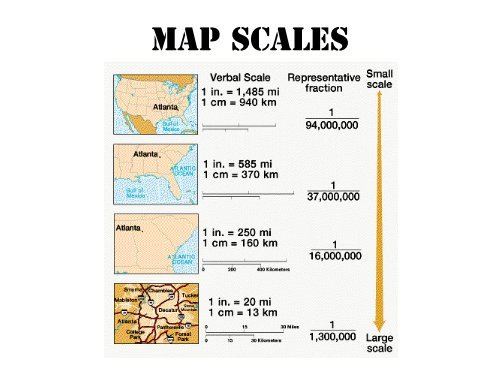
Effective practice exercises include converting map measurements to real-world distances using representative fractions, calculating travel distances between multiple points on a single map, and comparing large-scale versus small-scale maps showing the same region. Multi-step problems that require students to convert between units — such as centimeters on a map to kilometers in reality — build the layered reasoning that standardized assessments typically target. Map scale quizzes that progress from basic scale reading to complex calculations are especially useful for structured skill development.
What mistakes do students commonly make when working with map scales?
The most common error is confusing large-scale and small-scale maps — students often assume a 'large scale' means a map covers a large area, when in fact a large-scale map (like 1:1,000) shows a small area in great detail. Students also frequently forget to convert units before applying a scale ratio, leading to calculations that are off by a factor of 100 or more. A third common mistake is misreading graphic scales by measuring from the wrong starting point or not accounting for fractional segments.
How can I use map scale quizzes to support students at different skill levels?
For students still building foundational skills, start with graphic scale problems that require only measurement and multiplication before introducing representative fractions. More advanced learners can be challenged with multi-step problems that combine unit conversion, scale calculation, and comparison of different map types. On Wayground, teachers can apply accommodations such as reduced answer choices or read-aloud support to individual students, so the same quiz can serve the full range of learners in one classroom without requiring separate materials.
How do I use Wayground's map scale quizzes in my classroom?
Wayground's map scale quizzes are available as printable PDFs for traditional classroom use and in digital formats for technology-integrated environments, including the option to host them as a quiz directly on Wayground. Each quiz includes a complete answer key, making them practical for independent practice, homework, or formative assessment without additional prep. Teachers can filter resources by curriculum standard or learning objective to quickly locate materials that align with their current unit.
How do map scale skills connect to broader geography and math standards?
Map scale sits at the intersection of geography and mathematics, requiring students to apply proportional reasoning, unit conversion, and spatial thinking — all of which appear in both social studies and math standards across middle grades. In geography contexts, scale literacy is foundational to understanding map types, navigation, and geographic analysis. In math contexts, the same skills reinforce ratio and proportion concepts, making map scale an effective cross-curricular topic for reinforcing both subject areas simultaneously.

Accessibility
Features
Wayground Super
School & District
Wayground for Business
Create a quiz
Create a presentation
Wayground AI
Subjects
Mathematics
Social Studies
Science
Physics
Chemistry
Biology
About
Our Story
Wayground Blog
Media Kit
Careers
Support
F.A.Q.
Help & Support
Privacy Policy
Terms of Service
Teacher Resources
2026 Wayground


Get our app

