

Geography of China

Presentation
•
Social Studies, Geography, History
•
6th Grade
•
Medium

MAX SHEAHAN
Used 21+ times
FREE Resource
10 Slides • 7 Questions
1

2
OR
The Tibetan Plateau
The Tibetan Plateau is often called the "Roof of the World."

3
The Tibetan Plateau is rocky land surrounded by towering mountains. Because of its high elevation, the climate is very cold. The air is thin and dry. It even snows in the summer.

4
Multiple Choice

Why do you think geographers call the Tibetan Plateau the "Roof of the World"?
It is very large and at a very high elevation
It is hidden in the clouds like the sky
If you stand on it you are at the highest point on earth
You can't breathe there
5
Covers an area of about 105,000 square miles. It is considered one of the most dangerous deserts in the world. Its name means "once you go in, you will not come out". Desert winds and huge sand dunes bring dangerous sandstorms. Legend says that two armies and 300 cities are buried here.

6
Multiple Choice
What makes the Taklimakan Desert so dangerous?
thousands of miles across
sandstorms
high temps in summer, low temps in winter
All of these
7
Stretching over 500,000 miles, the Gobi Desert is one of the world's largest. Most of the desert is stony.

8
Multiple Choice
The Gobi Desert is used as a training ground for astronauts. Why do you think that is?
It gets really hot there.
It is really huge.
It has a similar environment to places like Mars.
It is at a high elevation.
9
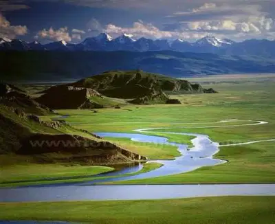
The Northeastern Plain is located east of present-day Mongolia. It is a land of low hills and plains. The natural vegetation is mostly prairie grass. In ancient times, the grass provided food for horses, sheep, and other animals raised by herders. Two major rivers run through the Northeastern Plain: the Liao (lyow) and the Sungari (SOONG-guh-ree).
The Northeastern Plain
10
Multiple Choice
Why do you think the Northeastern Plain would be good for farming?
It had flat land for planting.
It had grasslands for grazing animals.
Two rivers run through it.
All of these
11
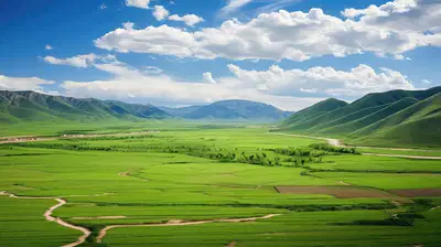
One of the two major regions in Inner China is the North China Plain, a flat region of grassland. Temperatures range from very warm in the summer to quite cold in the winter.
The North China Plain
12

This region is sometimes called the “Land of the Yellow Earth” because the ground is covered by yellow limestone silt. The silt comes from the Gobi Desert. It is carried by the wind to the North China Plain. The river that runs through the plain is also full of yellow silt. The silt gives the river its name, Huang He (Yellow River).
North China Plain
13
Multiple Choice
The Huang He River helps farmers with its fertile silt. What risk could it pose to farmers?
Too fertile
It could flood too much
It could dry up
None of these
14
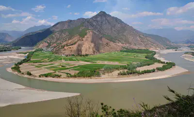
The Chang Jiang Basins are areas of low, wet coastal plains. The basins are located along the river called the Chang Jiang.
This river is even longer than the Huang He. In fact, Chang Jiang means “Long River.” It has hundreds of tributaries. People use the river to move goods between eastern and western areas of the region.
The Chang Jiang Basins
15
Multiple Choice
The Chang Jiang River was useful for many things including
transportation of goods
party boats
surfing
None of these
16
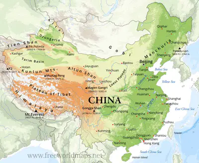
China is surrounded by water to the east. These seas became part of the Pacific Ocean further out.
Yellow Sea
East China Sea
South China Sea
17
Multiple Choice
What could the seas provide people in ancient China?
drinking water
water for crops
seafood source
All of these
Show answer
Auto Play
Slide 1 / 17
SLIDE
Similar Resources on Wayground

12 questions
The Rosetta Stone
Presentation
•
6th Grade
12 questions
Media and Mass Media
Presentation
•
6th Grade
12 questions
Canada's Political and Physical Features
Presentation
•
6th Grade
13 questions
Factors of Production
Presentation
•
6th Grade
14 questions
The Columbian Exchange Lesson
Presentation
•
6th Grade
14 questions
Alexander the Great
Presentation
•
6th Grade
11 questions
Judaism-World Religions
Presentation
•
6th Grade
15 questions
Latin America Vocabulary
Presentation
•
6th Grade
Popular Resources on Wayground
10 questions
Safety Day 2026 – Student Review

Quiz
•
9th Grade
21 questions
Continents and Oceans
Quiz
•
6th Grade
20 questions
Parts of Speech
Quiz
•
5th Grade
16 questions
Subject & Predicate
Quiz
•
5th Grade
25 questions
Multiplication Facts
Quiz
•
5th Grade
12 questions
Map Skills
Quiz
•
3rd Grade
22 questions
Continents and Oceans
Quiz
•
5th Grade
15 questions
Rounding Decimals
Quiz
•
5th Grade
Discover more resources for Social Studies
19 questions
Foundations of America
Quiz
•
6th - 8th Grade
5 questions
Mesopotamia Video Quiz

Interactive video
•
6th Grade
10 questions
Exploring the Age of Exploration: Key Events and Figures
Interactive video
•
6th - 10th Grade
15 questions
Middle Ages of the Middle East Vocab List (CFA #2)
Quiz
•
6th - 8th Grade
13 questions
Ancient Egypt
Interactive video
•
6th Grade
17 questions
Timelines
Quiz
•
6th Grade
11 questions
SWANA Unit test
Quiz
•
6th Grade
13 questions
Canada Map
Quiz
•
6th Grade