Search Header Logo
Topgraphic Maps Guided Lesson

Topgraphic Maps Guided Lesson

Assessment

Presentation

Science

6th - 8th Grade

Medium

NGSS
MS-ESS1-1, MS-ESS2-2, MS-LS1-6

+11

Standards-aligned

Created by

Bobby Menendez

Used 31+ times

FREE Resource

27 Slides • 23 Questions

1

media
media
media

2

3

media

4

media

5

media

6

media

7

media

8

media

9

media

10

media

11

media

12

media

13

Multiple Choice

Define what is meant by Contour Lines

1

Lines on a maps

2

Lines on maps that connect places with the same altitude or height above sea level.

3

Lines known as the contour intervals

14

media

15

media

16

media

17

Multiple Choice

How can you tell a map shows a steep slope?

1

The lines are far apart from each other

2

The lines are close to each other

18

Multiple Choice

What do contour lines that are farther apart represent?
1

waterfall

2

steep area

3

gradual/gentle slope

4

river

19

Multiple Choice

Question image

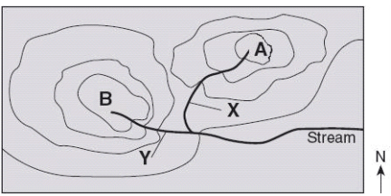
Which side is steeper?

1

The left side of the hill

2

The right side of the hill

20

media

21

Multiple Choice

Question image

On a topographic map, a series of closed lines forming closed circles would represent which of the following land features?

1

Hills

2

Road

3

River

4

Valley

22

media

23

Multiple Choice

The height above sea level is called
1

topographic

2

contour

3

elevation

4

depth

24

media

25

media

26

media

27

media

28

Multiple Choice

Question image

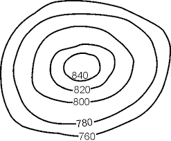
What is the contour interval on this map?

1

10

2

50

3

100

4

500

29

Multiple Choice

Question image

What is the contour interval of this map?

1

10

2

20

3

30

4

40

30

media

31

media

Contour lines form a “V” or “U” shape to indicate the
flow of a river or stream

The river or stream flows “out of the mouth” of the “V” or
“U” shape

Water flows downhill due to gravity

“V” or “U”

Shape

This river or

stream is flowing
to the southwest.

32

media

33

media

34

Multiple Choice

Question image
Which direction is the stream flowing?
1

northward

2

southward

3

westward

4

eastward

35

media

36

media

37

Multiple Choice

Question image

This is a meteor crater. Which of the following is a prediction of how the crater will change over the next 1,000 years?

1

The crater will become more shallow as the sides erode into the center.

2

The crater will become deeper as animals make the crater home and burrow deep into the rock.

3

The crater will not change over 1,000 years.

4

The crater will fill in with lava.

38

Multiple Choice

Question image

Gradient means..

1

The slope/steepness

2

The width

3

Contour line

39

Multiple Choice

Question image

Observe the image. Between which 2 points is the slope steeper?

1

A to B

2

C to D

40

Multiple Choice

Question image
What land form is this?
1

plain

2

valley

3

mountain

4

canyon

41

Multiple Choice

Question image

Which of the following best describes how mountains change over time?

1

The elevation of the peaks will decrease due to erosion.

2

The elevation of the peaks will increase due to weathering.

3

The elevation of the peaks will increase due to deposition.

4

Mountains stay the same, they never change.

42

Multiple Choice

Question image
What land form is this?
1

valley

2

canyon

3

mountain

4

plain

43

Multiple Choice

Question image
Determine the contour interval:
1
5 m
2
10 m
3
15 m
4
20 m

44

Multiple Choice

If contour lines are close together, then the slope is
1
gentle
2
steep
3
flat
4
going up and down

45

Multiple Choice

Question image
What are the darker lines called?
1
roads
2
index contour
3
contour interval
4
waves

46

Multiple Choice

Question image
What is the contour interval of the topographic map below?
1
400 m
2
200 m
3
100 m
4
80 m

47

Multiple Choice

Question image

Match the topographic map to its profile picture.

1
2
3
4

48

Multiple Choice

Question image
What is the elevation of point B?
1
800 ft
2
850 ft
3
900 ft
4
1000 ft

49

Multiple Choice

Question image
What is the difference in elevation between Point X and Point Y?
1
120 m
2
240 m
3
360 m
4
340 m

50

Match

Match the following topographic map with its description.

Steep south side

Two peaks, with east side higher

Gentle slope on all sides

Round hill with two peaks

media
media
media

Show answer

Auto Play

Slide 1 / 50

SLIDE