Search Header Logo
Science

Science

Assessment

Presentation

•

•

Practice Problem

•

Hard

Created by

Kyle Oakes

FREE Resource

21 Slides • 72 Questions

1

Multiple Select

Question image

What two possible techniques could scientists have used to create this map of the ocean ridges?

1

detecting new landforms

2

observing from underwater vehicles

3

monitoring sound waves

4

comparing mountain ranges

5

surveying land levels

2

Multiple Choice

Complete the sentence:


Volcanoes can form on _______________________

1

the ocean floor or land

2

plate movement

3

glaciers and icebergs

4

state boundaries

3

Multiple Choice

A landform is a physical feature on the Ocean’s surface.

1

True

2

False

4

Multiple Choice

Plateaus, valleys, canyons, and mountains are all examples of:

1

Highlands

2

Mantle areas

3

Landforms

4

Hydrosphere

5

Multiple Choice

A landform that rises high above the Earth’s surface:

1

Hill

2

Valley

3

Mountain

4

Plateau

6

Multiple Choice

Question image

A close-up look at Earth shows you many natural features on the surface. These features are called...

1

highlands

2

landforms

7

Multiple Choice

A natural elevation of the Earth’s surface, smaller than a mountain...

1

Hill

2

Valley

3

Mountain

4

Plateau

8

Multiple Choice

Which shows the elevation of an area using contour lines?

1

Mountains

2

Faults

3

Topographical map

4

Cartographer

9

Multiple Choice

A deep valley with high, steep sides...

1

Hill

2

Valley

3

Mountain

4

Canyon

10

Multiple Choice

Latitude and longitude are used to:

1

Find a location of a specific place or landform feature on a map.

2

Determine the shape of the Earth.

11

Multiple Choice

Where a body of water meets land...

1

Ocean

2

Lake

3

Coast

4

River

12

Multiple Choice

An area with very little precipitation...

1

Hill

2

Desert

3

Canyon

4

Plateau

13

Multiple Choice

The flattest part of the ocean floor is called...

1

abyssal plain

2

continental shelf

14

Multiple Choice

The abyssal plains cover about ___ percent of the Earth’s surface.

1

40

2

50

3

60

4

70

15

Multiple Choice

Earth’s outer layer is called...

1

Crust

2

Mantle

3

Outer core

4

Inner core

16

Multiple Choice

A map that shows the elevation of an area using shades is called:

1

Topographical map.

2

Relief map

3

Physical map

17

Multiple Choice

The place where two plates meet is called...

1

Plate boundary

2

Volcanic plates

18

Multiple Choice

Is used to describe how far north or south a place is from the equator:

1

Latitude

2

Longitude

3

Prime Meridian

19

Multiple Choice

The deepest part of the Ocean floor is called:

1

Seamount

2

Trench

20

Multiple Choice

An opening on Earth’s surface where melted rock or gases are forced out is called:

1

Earthquake

2

Volcano

21

Multiple Choice

What is a topographic map?

1

shows elevation of an are using lines

2

an opening in the earth's surface where gas and rock are forced out

3

a sudden movement of the earth's crust

4

a large landmass

22

Multiple Choice

What is an earthquake?

1

a sudden movement of the earth's crust

2

a very large piece of the earth's crust

3

used to describe how far north or south a place is from the equator

4

a large landmass

23

Multiple Choice

What is latitude?

1

used to describe how far east or west a place is from the Prime Meridian

2

shows elevation of an area using lines

3

used to describe how far north or south a place is from the equator

4

a sudden movement of the earth's crust

24

Multiple Choice

What is longitude?

1

a large landmass

2

used to describe how far east or west a place is from the prime meridian

3

a physical feature of the earth's surface

4

used to describe how far north or south a place is from the equator

25

Multiple Choice

What is a volcano?

1

a very large piece of the earth's crust

2

a sudden movement of the earth's surface

3

a large landmass

4

an opening in the earth's surface where melted rock or gases are forced out

26

Fill in the Blank

_______ is a process that moves weathered rock.

27

Multiple Choice

a process in which a force acts on a rock and breaks it into smaller pieces

1

erosion

2

sediment

3

rate of erosion

4

weathering

28

Multiple Choice

If you see contour lines on a map that are very close together, which of the following landforms is most likely in that location on the map?

1

a flat, sandy beach

2

a mountain

3

the plains

29

Multiple Choice

How do contour lines on a map show a flat plain on a map?

1

The contour lines are far apart for a plain.

2

The contour lines are very close together to show a flat plain.

3

The contour lines are wide and short to show a flat plain.

4

The contour lines are long and narrow to show a flat plain.

30

Multiple Choice

A volcano is most likely to occur __________.

1

in a valley

2

on land

3

near the boundaries of tectonic plates

4

underwater

31

Multiple Choice

How do scientists create a map of the ocean floor?

1

Scientists compare mountain ranges.

2

Scientists use sonar or sound waves to map the ocean floor's features.

3

Scientists measure land levels.

4

Scientists look for new landforms.

32

Multiple Choice

How would a map of the land and the ocean be similar?

1

Both maps show plant life.

2

Both maps show earthquakes.

3

Both maps show valleys and mountains.

33

Multiple Choice

A river, delta, mountain, valley, plains, and plateau are all examples of ________________.

1

the Earth's mantle.

2

landforms.

3

the hydrosphere.

34

Multiple Choice

A landform is __________________.

1

part of the hydrosphere.

2

the core of the Earth.

3

molten rocker beneath the Earth's surface.

4

a feature of the Earth's surface.

35

Multiple Choice

Question image

Sediments are tiny bits of soil or rock that have been broken down and deposited.

1

True

2

False

36

Multiple Select

Question image

Which are deposit most of the sediments?

1

Water

2

Wind

37

Multiple Choice

Question image

Sedimentary rock forms from sediments that are not pressed together in layers.

1

True

2

False

38

Multiple Choice

Question image

Fossils, remains or imprints of living things from the

1

Past

2

Present

39

Multiple Choice

A type of rock made from molten lava

1

igneous rock

2

sedimentary rock

3

metamorphic rock

4

fossil

40

Multiple Choice

Rock formed from particles in the environment that settle to form layers

1

igneous rock

2

sedimentary rock

3

metamorphic rock

4

fossil

41

Multiple Choice

A type of rock formed by great pressure and very high temperatures

1

igneous rock

2

sedimentary rock

3

metamorphic rock

4

fossil

42

Multiple Choice

Mineralized remains or evidence of plants and animals that lived long ago

1

igneous rock

2

sedimentary rock

3

metamorphic rock

4

fossil

43

Multiple Choice

Question image

This organism is dissolved in the Earth and leaves a 3D indentation

1

trace fossil

2

mold fossil

3

true form fossil

4

cast fossil

44

Multiple Choice

Question image

Impressions such as footprints, burrows, or nests once made by living organisms

1

trace fossil

2

mold fossil

3

true form fossil

4

cast fossil

45

Multiple Choice

Question image

Mineralized sediment fills a cavity and recreates the shape of the remains.

1

trace fossil

2

mold fossil

3

true form fossil

4

cast fossil

46

Multiple Choice

Question image

This fossil is formed when the dead plant or animal IS the fossil.

1

trace fossil

2

mold fossil

3

true form fossil

4

cast fossil

47

Multiple Choice

Question image

Which layer contains fossils of the oldest organisms? Explain your answer.

1

Layer A because it has the weirdest creature

2

Layer D because it's on the top

3

Layer A because it's on the bottom

4

Layer D because dinosaurs are old

48

media

49

media

50

Multiple Choice

Tiny bits of soil or rock that have been broken down and deposited are called ________?

1

deposits

2

sediments

3

layers

4

rocks

51

media

52

media

53

Multiple Choice

Where are fossils preserved in?

1

metamorphic rocks

2

The Rock

3

sedimentary rocks

4

igneous rocks

54

media

55

media

56

Multiple Choice

Fossils found closer to the surface are usually ____________ than the other fossils deeper below.

1

older

2

brighter

3

newer

4

darker

57

media

58

media

59

Multiple Choice

What can affect the formation and patterns found in rock layers?

1

earth forces

2

dark forces

3

energy

4

sedimentary rocks

60

media

61

media

62

Multiple Choice

How are canyons formed?**

1

water slowly removes rock particles

2

cliffs decide to break off

3

volcanoes melt the rocks

63

Multiple Choice

Question image

The oldest layer of rock is layer _________________, and the youngest layer of rock is layer ____________________.

1

1; 5

2

2;4

3

3;2

4

4;3

64

media

65

Multiple Choice

Weathering is the ________ process that breaks down materials into smaller pieces.

1

fast

2

slow

3

neutral

4

speedy

66

media

67

media

68

Multiple Choice

The action of rocks and sediments grinding and wearing away surfaces is called _________.

1

weathering

2

cracks

3

abrasion

4

polishing

69

media

70

Multiple Select

What three things can cause chemical weathering?

1

water

2

ash

3

oxygen

4

abrasion

5

living things

71

media

72

Multiple Choice

The movement of weathered materials from one place to another is called ________?

1

erosion

2

weathering

3

deposition

73

media

74

Multiple Choice

What causes material to move?

1

mud

2

gravity

3

land

4

rock

75

media

76

Multiple Choice

Sediments that build up turns into a landform called _______?

1

island

2

peninsula

3

delta

4

beach

77

media

78

Multiple Choice

What do you call deposits of wind-blown sand?

1

sand dune

2

beach

3

mountain

4

sand castle

79

media

80

Multiple Choice

An area of shoreline made of material deposited by waves is called a _______.

1

beach

2

sand dune

3

ocean

4

cliff

81

media

82

Multiple Choice

What forms where snow collects quickly and melts slowly?

1

avalanche

2

hill

3

glaciers

83

media

84

Multiple Choice

Too much rain can have negative effects on some wildlife.

1

true

2

false

85

Multiple Choice

______________________ is the study of Earth's shapes and features.

1

interval

2

topography

3

elevation

4

contour

86

Multiple Choice

______________________ are lines that connect areas of the same elevation and eventually form a closed loop.

1

contour lines

2

parallel lines

3

intersecting lines

4

relief lines

87

Multiple Choice

_______________ is the distance between contour lines that represent the difference in elevation points.

1

topography

2

topographic map

3

contour lines

4

contour intervals

88

Multiple Choice

_____________ is the height above sea level.

1

elevation

2

relief

3

contour

4

topography

89

Multiple Choice

The closer the contour lines are together, the ______________ the slope.

1

thinner

2

wider

3

flatter

4

steeper

90

Multiple Choice

Question image

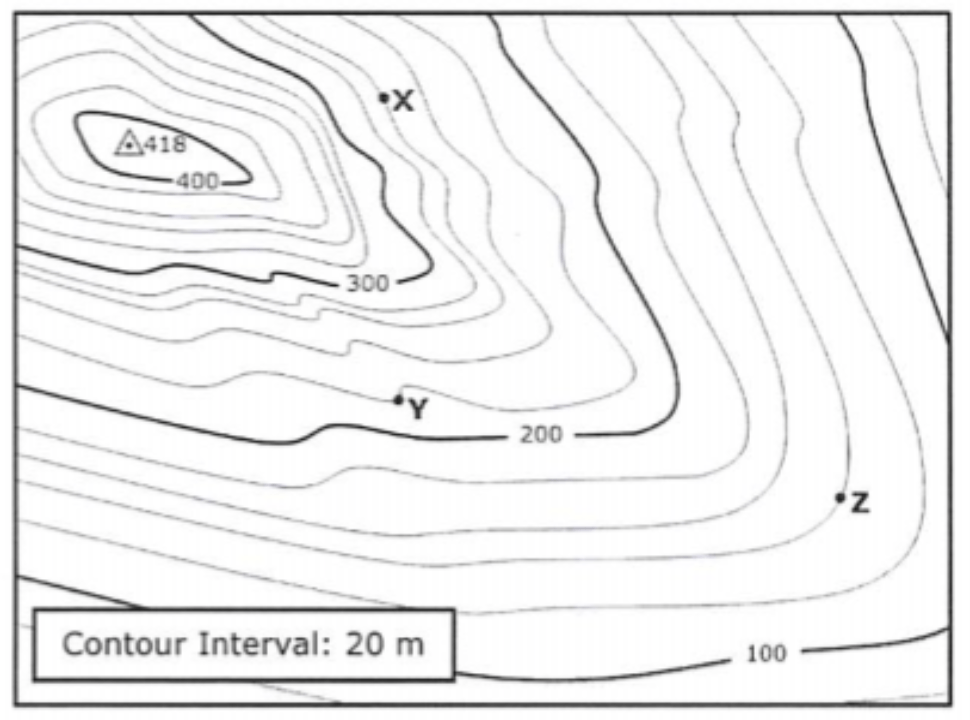
What is the elevation of point X?

1

240 meters

2

250 meters

3

260 meters

4

270 meters

91

Multiple Choice

Question image

What is the elevation of point Y?

1

220 meters

2

210 meters

3

200 meters

4

215 meters

92

Multiple Choice

Question image

What is the elevation of point Z?

1

130 meters

2

135 meters

3

140 meters

4

150 meters

93

Multiple Choice

Question image

What is the difference in elevation between points X and Y?

1

30 meters

2

20 meters

3

40 meters

4

10 meters

Question image

What two possible techniques could scientists have used to create this map of the ocean ridges?

1

detecting new landforms

2

observing from underwater vehicles

3

monitoring sound waves

4

comparing mountain ranges

5

surveying land levels

Show answer

Auto Play

Slide 1 / 93

MULTIPLE SELECT