
8.11c
Presentation
•
Science
•
8th Grade
•
Hard

James Gonzalez
FREE Resource
18 Slides • 35 Questions
1
Day 8- Earth Science
TEKS 8.8C, 8.8D, 8.9A 8.9B, 8.9C 8.10A, 8.10C 8.10B, 8.11A, 8.11B, 8.11C, 8.11D

2
Electromagnetic Spectrum
Used to learn about the universe. It's range of radiation at different wavelengths.
Light Waves-can tell us what an object is made up of in space.
Radio Waves- can be used to show us the existence and distance of objects in space.
Red shift- An object that has longer wave lengths appears red. That means the object is moving away from Earth.
Blue Shift- An object that has shorter wave length appears blue. This means the object is moving toward the Earth.

3
Multiple Choice

Which of the following has the most energy?
4
Multiple Choice

Which of the following has the longest wavelength?
5
Light Years
The distance light travels in one year. Used to measure distance in space.
The NEAREST star to Earth is our SUN. It is fairly "average" star in the H-R diagram's "Main Sequence." Our Sun is surprisingly stable,providing Earth with just the right sunlight for life to evolve on our planet. It is approximatley 8 light minutes away from Earth.

6
Multiple Choice
7
Multiple Choice
8
Plate Tectonics
Plate tectonics is the movement of large sections of the Earth's crust called Tectonic Plates. In 1915 Alfred Wegner proposed his theory of "CONTINENTIAL DRIFT." Wegner proposed continents fit together like puzzles(Pangea) , Fossils of animal found on different continents, glacier scarring, rocks of same age across the ocean

9
Multiple Choice
10
Multiple Choice

11
Multiple Choice

Who is the scientist who proposed Continental Drift Theory?
12
Plate Tectonics and Crustal Features
The tectonic plates are floating on top of magma which causes them to move. Tectonic plate collide with one another along Plate Boundaries. There are several types of plate boundaries.
Divergent- Two plates move away from each other.
Crustal Feature: Ridge (water)
Rift: (land)
Convergent - two plates collide together.
Crustal Feature: Subduction Zone causes volcanoes.
Folding Mountains
Transform-Two plate slide past one another.
Crustal Feature: neither plate creates or destroys. Causes earthquakes
Caused by

13
Multiple Choice
14
Multiple Choice
15
Multiple Choice
16
Multiple Choice
17
Topographic Maps
A map used to identify land features. They are maps of 2-D drawings of 3-d images.
A topographic map is often a very large scale map that shows the shape of the land's surface. Contour lines are imaginary lines that connect places of equal elevation. When contour lines are close together, the slope is very steep, When contour lines are far apart, the slope is very shallow.

18
Multiple Choice
19
Multiple Choice
20
Multiple Choice

21
Multiple Choice

22
Topographic Maps
Can be used to show weathering, erosion, and deposition.
Erosion-Movement of matter from one place to another place, caused by wind, ice or gravity.
Deposition- The settling of material in a new location.
Weathering- breaking down of material like rock into smaller pieces by wind or moving water. Can cause mountains to become smaller.

23
Energy
The source of almost all Earth's heat energy is the SUN. The Sun gives off its heat in the form of electromagnetic radiation, which travels through space. The Sun's heat is distributed throughout the atmosphere. land, and the oceans by radiation, conduction and convection, providing the energy to make energy to make weather.

24
Multiple Choice
25
Wind Currents
Wind can be defined as air moving from area of High pressure to an area of low pressure in the atmosphere. The greater the difference between high and low pressure, the faster the air moves. If all areas across Earth's surface had the same air pressure, there would be no wind. The Sun, however, heats some part of the Earth more than the others, creating pressure differences . Thus winds are driven by solar energy

26
Multiple Choice
27
Multiple Choice
28
Ocean Currents
Are mainly caused by wind and differences in temperature. Currents are responsible for a vast amount of movement of the water found in the Earth's oceans. The ocean plays a starring role in whatever happens with the environment. One big part of its role is to soak up energy (heat) and distribute it more evenly around the Earth. Ocean Currents influence the weather in coastal areas.

29
Multiple Choice
30
Multiple Choice
31
Ocean Affects Climate on Land
When the sunrays hot the surface of the Earth, it is heated. However, there is a big difference between how fast the land and the sea are heated. The land is heated a lot faster than the sea. The air above land is heated faster then the air above the sea. The hot air above land rises high into the sky, where it cools off. High in the sky the cold air now moves out over the sea. Here it sinks down pressing cool air towards land. The air moving towards land is what we know as WIND (convection current). At night the opposite happens. That means it is the sun that makes wind blow.

32
Multiple Choice
33
Multiple Choice
34
Multiple Choice
35
Weather Maps
A weather map or chart shows the weather conditions at a specific point in time.

36
Weather Map Symbols
High Pressure- Region where the atmosphere's pressure is greater at ground level then surrounding areas. Resulting in HAPPY weather.
Low Pressure- Region where the atmosphere's pressure is less at ground level than surrounding areas. Results in potentially SAD weather.
Warm Front and Cold Fronts- boundary where an air masses meet, can be area where storms form.
Occluded Front- cold air over takes warm air or vice versa.
Stationary Front- boundary between warm and cold air has little or no movement.

37
Multiple Choice

38
Multiple Choice

39
Multiple Choice
40
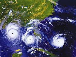
Hurricanes
Hurricanes get their energy from warm water which create a very large area of low pressure. As ocean water increases in temperature, it slowly turns into water vapor. The warmer the water temperatures , the higher the water vapor rises. After the water vapor has risen, it begins condensing into rain in the form of clouds. When the clouds release the rain, heat is released as well, when the heat stays in the same are, the eye of the hurricane is formed

41
Multiple Choice

How are hurricanes categorized?
42
Multiple Choice
43
Multiple Choice
44
Organisms and Environment
There are three main ecosystems.
Terrestrial-Land
Marine-Salt water
Freshwater-Freshwater
Animals in each of these ecosystems interact in different ways.

45
Organisms and Environment
Predator- hunts animals for food.
Prey- hunted for food.
Host- Provides benefits to parasite but the parasite harms the host in the process.
Parasite- receives nutrition from a host that live on but harms the host in the process.
Producer- produces its own food.
Primary Consumer- gets its energy from consuming plants. Also known as Herbivores.
Secondary Consumer- Gets its energy from consuming producers and other consumers.
Decomposer- Breaks down dead organisms for nurients

46
Multiple Choice
47
Multiple Choice
48
Fill in the Blanks
49
Competition
Organisms and populations in an ecosystem depend on and may compete for biotic and abiotic factors such as Light, water, range in temp., or soil composition.
Competition- the struggle between organisms to get as many resources as possible to survive and reproduce.
Abiotic- the never living parts of an environment.
Biotic- the living parts of an environment.

50
Multiple Choice
51
Multiple Choice
52
Multiple Choice
53
Short and Long Term Environmental Affect
Short and Long term environmental changes affect organisms and traits in subsequent populations.
Natural Selection- process by which organisms with favorable characteristics for survival reproduce more successfully.
Adaptation- The ability of an organism to survive longer, find food, and mate.
Mutation- A sudden change in trait of an organisms that maybe beneficial or harmful.
Speciation- the formation of new and distinct species in the course of evolution.
Long Term Environmental Changes- can cause mass extinctions and lead to speciation. example: global warming, ice ages.
Short Term Environmental Changes-Will cause organisms to temporarily leave an area. Example: Storms, Hurricanes, Drought.

Day 8- Earth Science
TEKS 8.8C, 8.8D, 8.9A 8.9B, 8.9C 8.10A, 8.10C 8.10B, 8.11A, 8.11B, 8.11C, 8.11D
Show answer
Auto Play
Slide 1 / 53
SLIDE
