Locating Earthquake Epicenters
Interactive Video
•
Physics, Mathematics, Geography
•
9th - 10th Grade
•
Practice Problem
•
Hard

Patricia Brown
FREE Resource
Read more
10 questions
Show all answers
1.
MULTIPLE CHOICE QUESTION
30 sec • 1 pt
What is the significance of the P-wave and S-wave arrival times in locating an earthquake's epicenter?
They show the direction of the earthquake's movement.
They are used to calculate the distance to the epicenter.
They indicate the depth of the earthquake.
They help determine the earthquake's magnitude.
2.
MULTIPLE CHOICE QUESTION
30 sec • 1 pt
How is the difference in arrival times of P-wave and S-wave used?
To determine the earthquake's depth.
To find the distance to the epicenter.
To calculate the earthquake's magnitude.
To identify the type of fault involved.
3.
MULTIPLE CHOICE QUESTION
30 sec • 1 pt
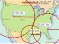
What is the purpose of drawing a circle around Salt Lake City on the map?
To indicate the direction of the earthquake's movement.
To show the area affected by the earthquake.
To mark the earthquake's epicenter.
To represent the possible locations of the epicenter.
4.
MULTIPLE CHOICE QUESTION
30 sec • 1 pt
How many kilometers away is Salt Lake City from the epicenter according to the example?
1,300 km
1,800 km
800 km
2,000 km
5.
MULTIPLE CHOICE QUESTION
30 sec • 1 pt
What is the role of the scale on the map?
To determine the depth of the earthquake.
To identify the type of seismic waves.
To measure the earthquake's magnitude.
To measure distances accurately.
6.
MULTIPLE CHOICE QUESTION
30 sec • 1 pt
Why is it necessary to use multiple cities like Houston in the process?
To confirm the earthquake's magnitude.
To narrow down the possible epicenter locations.
To determine the earthquake's depth.
To calculate the speed of seismic waves.
7.
MULTIPLE CHOICE QUESTION
30 sec • 1 pt
What is the final step in determining the earthquake's epicenter?
Marking the intersection of all circles.
Drawing a circle around the last city.
Calculating the earthquake's magnitude.
Measuring the distance from the epicenter to the nearest city.
Access all questions and much more by creating a free account
Create resources
Host any resource
Get auto-graded reports
Continue with Google

Continue with Email
Continue with Classlink
Continue with Clever
or continue with
Microsoft
%20(1).png)
Apple
Others
Already have an account?
