Geography of the British Isles
Interactive Video
•
Geography, History, Social Studies
•
6th - 7th Grade
•
Practice Problem
•
Hard

Patricia Brown
FREE Resource
Read more
10 questions
Show all answers
1.
MULTIPLE CHOICE QUESTION
30 sec • 1 pt
What are the two main islands that make up the British Isles?
Ireland and Greenland
Great Britain and Ireland
Greenland and Iceland
Great Britain and Iceland
2.
MULTIPLE CHOICE QUESTION
30 sec • 1 pt
Which island is known as the Emerald Isle?
Ireland
Iceland
Great Britain
Greenland
3.
MULTIPLE CHOICE QUESTION
30 sec • 1 pt
What is the capital of Wales?
Cardiff
Edinburgh
London
Belfast
4.
MULTIPLE CHOICE QUESTION
30 sec • 1 pt
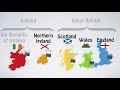
Which region is not part of Great Britain?
England
Wales
Scotland
Northern Ireland
5.
MULTIPLE CHOICE QUESTION
30 sec • 1 pt
Which country is part of the European Union?
United Kingdom
Wales
Republic of Ireland
Scotland
6.
MULTIPLE CHOICE QUESTION
30 sec • 1 pt
What currency is used in the United Kingdom?
Yen
Euro
Pound
Dollar
7.
MULTIPLE CHOICE QUESTION
30 sec • 1 pt
Which regions form the United Kingdom?
England, Scotland, Ireland, and Northern Ireland
England, Wales, Ireland, and Northern Ireland
England, Wales, Scotland, and Republic of Ireland
England, Wales, Scotland, and Northern Ireland
Access all questions and much more by creating a free account
Create resources
Host any resource
Get auto-graded reports
Continue with Google

Continue with Email
Continue with Classlink
Continue with Clever
or continue with
Microsoft
%20(1).png)
Apple
Others
Already have an account?
