Understanding Topographic Maps Concepts
Interactive Video
•
Science, Geography
•
6th - 7th Grade
•
Practice Problem
•
Hard

Patricia Brown
FREE Resource
Read more
10 questions
Show all answers
1.
MULTIPLE CHOICE QUESTION
30 sec • 1 pt
What is the primary purpose of taking notes during the video tutorial?
To submit them for grading
To keep track of learning progress
To use them for a different subject
To share with classmates
2.
MULTIPLE CHOICE QUESTION
30 sec • 1 pt
How do contour lines on a topographic map help in understanding the terrain?
They indicate the type of vegetation
They show the distance between landmarks
They join points of equal elevation
They represent the temperature variations
3.
MULTIPLE CHOICE QUESTION
30 sec • 1 pt
What does a closer spacing of contour lines on a topographic map indicate?
A more level terrain
A steeper slope
A flat plain
A riverbed
4.
MULTIPLE CHOICE QUESTION
30 sec • 1 pt
How can you determine the contour interval if it's not given on a topographic map?
By measuring the distance between lines
By counting the number of lines between index contours
By looking at the map's legend
By checking the color of the lines
5.
MULTIPLE CHOICE QUESTION
30 sec • 1 pt
What is the difference between a topographic map and a satellite map?
Both show elevation but in different formats
Topographic maps show elevation, satellite maps show a photographic view
Satellite maps show elevation, topographic maps show a photographic view
Both are photographic views but from different angles
6.
MULTIPLE CHOICE QUESTION
30 sec • 1 pt
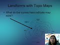
What feature on a topographic map indicates the presence of a river?
Circular lines
V-shaped or U-shaped curves
Dotted lines
Straight lines
7.
MULTIPLE CHOICE QUESTION
30 sec • 1 pt
In the practical application section, which point was identified as having the steepest slope?
Point C
Point D
Point B
Point A
Access all questions and much more by creating a free account
Create resources
Host any resource
Get auto-graded reports
Continue with Google

Continue with Email
Continue with Classlink
Continue with Clever
or continue with
Microsoft
%20(1).png)
Apple
Others
Already have an account?
