Free Printable Countries in Africa Worksheets for Year 8
Explore Year 8 countries in Africa with our comprehensive collection of free printable worksheets and practice problems, featuring detailed answer keys to help students master African geography through engaging PDF activities.
Explore printable Countries in Africa worksheets for Year 8
Countries in Africa worksheets for Year 8 students available through Wayground (formerly Quizizz) provide comprehensive coverage of the diverse nations across the African continent, offering students detailed exploration of geographical boundaries, capital cities, physical features, and regional classifications. These educational resources strengthen critical map reading skills, spatial awareness, and knowledge of African political geography while developing students' ability to identify and analyze the relationships between countries, their natural resources, and their positions within sub-regional organizations like the Economic Community of West African States and the Southern African Development Community. The collection includes practice problems that challenge students to demonstrate their understanding through location identification exercises, comparative analysis activities, and comprehensive review materials, with each worksheet featuring a corresponding answer key and available as free printable pdf resources that support both independent study and classroom instruction.
Wayground (formerly Quizizz) empowers educators with an extensive library of millions of teacher-created resources specifically designed for Year 8 geography instruction, featuring robust search and filtering capabilities that allow teachers to quickly locate materials aligned with specific curriculum standards and learning objectives for African geography studies. The platform's differentiation tools enable teachers to customize worksheets based on individual student needs, providing options for remediation through foundational country identification exercises and enrichment through advanced geopolitical analysis activities that explore economic partnerships and cultural connections between African nations. These resources are available in both printable and digital formats, including downloadable pdf versions, giving teachers the flexibility to incorporate them seamlessly into lesson planning, homework assignments, assessment preparation, and targeted skill practice sessions that help students master the complex geography of Africa's 54 sovereign nations.
FAQs
How do I teach students to identify the countries in Africa?
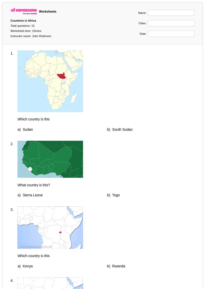
Start by grouping Africa's 54 sovereign nations into five regional clusters: North, West, East, Central, and Southern Africa. Teaching by region helps students build spatial anchors before memorizing individual countries. Use labeled and blank outline maps in sequence, first having students trace borders with a labeled reference, then reproduce them independently. Pairing map work with brief notes on each region's defining physical features, such as the Sahara, the Rift Valley, or the Congo Basin, gives students geographic context that makes country placement more memorable.
What are the most common mistakes students make when learning African geography?
The most frequent errors involve confusing similarly named or geographically adjacent countries, such as Niger and Nigeria, Guinea and Equatorial Guinea, or Congo and the Democratic Republic of the Congo. Students also tend to misplace landlocked nations like Chad, Mali, and Zambia because they lack coastal reference points. Another common misconception is underestimating Africa's geographic scale, which leads to imprecise placement of countries in the interior. Targeted practice with blank outline maps and capital city matching exercises can address all three of these error patterns directly.
What exercises help students practice locating and naming African countries?
Blank outline map exercises are the most effective practice format because they require active recall rather than recognition. Supplement these with capital-to-country matching, regional sorting activities, and map labeling tasks that progress from heavily guided to fully independent. Incorporating physical features alongside political borders, such as asking students to label the Sahel or the Great Rift Valley in relation to surrounding countries, reinforces spatial reasoning. Regular low-stakes quizzes on subsets of countries by region prevent the cognitive overload that comes from trying to memorize all 54 nations at once.
How do I use Countries in Africa worksheets from Wayground in my classroom?
Wayground's Countries in Africa worksheets are available as printable PDFs for traditional classroom use and in digital formats for technology-integrated learning environments, and can also be hosted as a quiz directly on Wayground. Printable versions work well for independent seat work, map labeling stations, or homework assignments, while digital formats support remote learning and self-paced practice. Each worksheet includes a detailed answer key, so students can self-check during independent work or teachers can use it for efficient grading. Wayground also supports student-level accommodations such as read aloud, extended time, and reduced answer choices, which can be applied individually so all learners can access the same geographic content.
How do I differentiate Countries in Africa worksheets for students at different skill levels?
For foundational learners, begin with partially labeled maps and word banks so students focus on recognition before moving to recall. More advanced students can work with blank maps, capitals, and physical feature labeling simultaneously. On Wayground, teachers can apply individual accommodations such as reduced answer choices to lower cognitive load for struggling students, or extended time for students who need it, without affecting the experience of the rest of the class. Grouping worksheets by region rather than assigning all 54 countries at once is an effective scaffold regardless of skill level.
What geographic concepts should students understand before studying the countries of Africa?
Students should be comfortable with cardinal and intermediate directions, basic map scale, and the difference between political and physical maps before diving into African country identification. An understanding of continents, hemispheres, and lines of latitude and longitude also helps, since Africa straddles the equator and spans both the Northern and Southern hemispheres. Familiarity with terms like landlocked, peninsula, and island nation will make regional characteristics of countries like Ethiopia, Somalia, and Madagascar easier to contextualize.