Year 1 mountains worksheets and printables help young learners discover different types of mountains, their features, and locations through engaging practice problems with comprehensive answer keys available as free PDF downloads.
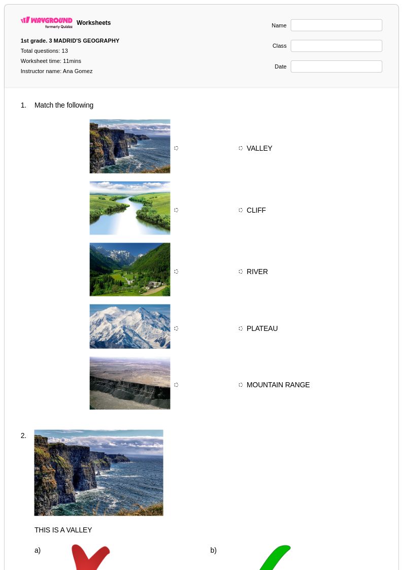
Mountains worksheets for Year 1 students available through Wayground (formerly Quizizz) introduce young learners to fundamental geographic concepts through age-appropriate activities and visual exercises. These educational resources help first-grade students develop essential skills in spatial awareness, landform identification, and basic geographic vocabulary while exploring the fascinating world of mountain formations. The worksheets feature engaging practice problems that encourage students to recognize different types of mountains, understand their basic characteristics, and compare mountains to other landforms like hills and valleys. Teachers can access comprehensive materials that include detailed answer keys, making assessment and feedback more efficient, while students benefit from structured learning experiences available in convenient pdf format as free printables that support both classroom instruction and independent study.
Wayground (formerly Quizizz) empowers educators with an extensive collection of teacher-created mountain geography resources specifically designed for Year 1 learners, drawing from millions of high-quality educational materials that have been developed and refined by classroom professionals. The platform's robust search and filtering capabilities allow teachers to quickly locate worksheets that align with specific learning standards and curriculum requirements, while built-in differentiation tools enable customization to meet diverse student needs and learning styles. These versatile resources are available in both printable and digital formats, including downloadable pdf options, providing maximum flexibility for lesson planning, targeted remediation for struggling learners, enrichment activities for advanced students, and regular skill practice that reinforces geographic concepts. The comprehensive worksheet collections support teachers in creating engaging, standards-aligned instruction that builds foundational knowledge about mountains and their role in shaping our world's diverse landscapes.
FAQs
How do I teach mountain formation to students?
Teaching mountain formation works best when students can connect the three main formation types to the tectonic forces behind them: fold mountains form from colliding plates, fault-block mountains from fractures in the crust, and volcanic mountains from magma activity. Using cross-section diagrams alongside real-world examples like the Himalayas, Sierra Nevada, and Cascades helps students visualize processes that unfold over millions of years. Pairing visual models with structured note-taking or comparison activities reinforces the distinctions between formation types and prepares students for map and elevation work.
What exercises help students practice reading topographic maps of mountains?
Effective topographic map practice involves having students identify contour lines, calculate elevation changes between intervals, and determine slope steepness by analyzing how closely lines are spaced. Exercises that ask students to trace a hiking route and predict terrain changes, or to compare two mountain profiles side by side, build spatial reasoning alongside map literacy. Worksheets that integrate labeled diagrams with short-answer questions help students connect the abstract contour representation to real mountain terrain.
What common mistakes do students make when learning about mountain types?
The most frequent misconception is that all mountains are volcanic, since volcanic mountains are the most visually dramatic and culturally prominent. Students also commonly confuse fold mountains with fault-block mountains, failing to distinguish between compression forces and tension forces in the crust. Another error is conflating elevation with altitude effects on climate, not understanding why temperature decreases as elevation increases even in tropical mountain regions.
How does altitude affect climate and ecosystems in mountain regions?
As altitude increases, atmospheric pressure drops and temperatures decrease at a rate of roughly 3.5°F per 1,000 feet, which creates distinct vegetation zones from base to summit. This is why a single mountain can support tropical forest at its base, temperate woodland in the middle elevations, and alpine tundra near the summit. Teaching students to map these biome transitions vertically is an effective way to reinforce both climate science and ecosystem concepts simultaneously.
How do I use Wayground's mountains worksheets in my classroom?
Wayground's mountains worksheets are available as printable PDFs for traditional classroom use and in digital formats for technology-integrated learning environments, and teachers can also host them as a quiz directly on Wayground. This flexibility makes them suitable for in-class instruction, independent practice, homework assignments, or remote learning. Each worksheet includes a complete answer key, so teachers can use them for guided practice, self-assessment, or formative review without additional preparation.
How can I differentiate mountains worksheets for students with different learning needs?
On Wayground, teachers can apply individual student accommodations including extended time, read-aloud support for students who need questions read to them, and reduced answer choices to lower cognitive load for students who need it. Font size and display themes can also be adjusted through reading mode for accessibility. These settings are saved per student and reapply automatically in future sessions, so differentiation requires no repeated setup.