Free Printable Locating Earthquakes Worksheets for Class 7
Class 7 students can master locating earthquakes with Wayground's comprehensive collection of free worksheets, printables, and practice problems that include detailed answer keys and downloadable PDFs for effective Earth science learning.
Explore printable Locating Earthquakes worksheets for Class 7
Locating earthquakes represents a fundamental skill in Class 7 Earth and Space Science, requiring students to master the interpretation of seismic data and understand the geographic distribution of seismic activity worldwide. Wayground's comprehensive collection of locating earthquakes worksheets provides seventh-grade students with structured practice problems that develop their ability to triangulate earthquake epicenters using seismograph data from multiple recording stations. These educational resources strengthen critical analytical skills including data interpretation, mathematical calculations involving time-distance relationships, and spatial reasoning as students work with seismic wave arrival times to pinpoint earthquake origins. The worksheets feature authentic scenarios and real seismological data, with accompanying answer keys that enable independent learning and self-assessment. Available as free printable pdf downloads, these practice materials systematically build student competency in using triangulation methods, reading seismograms, and understanding how scientists determine both the location and magnitude of seismic events.
Wayground, formerly Quizizz, empowers educators with millions of teacher-created resources specifically designed for locating earthquakes instruction, featuring robust search and filtering capabilities that allow teachers to quickly identify materials aligned with specific learning standards and grade-level expectations. The platform's differentiation tools enable instructors to customize worksheet difficulty levels, modify problem complexity, and adapt content to meet diverse student needs within the same Class 7 classroom. Teachers can access these resources in both printable and digital formats, including downloadable pdf versions that facilitate seamless integration into existing lesson plans and remote learning environments. These flexible features support comprehensive instructional planning by providing materials suitable for initial skill introduction, guided practice sessions, independent remediation work, and enrichment activities for advanced learners, ensuring that all students develop proficiency in the essential geoscience skill of earthquake location analysis.
FAQs
How do I teach students to locate earthquake epicenters?
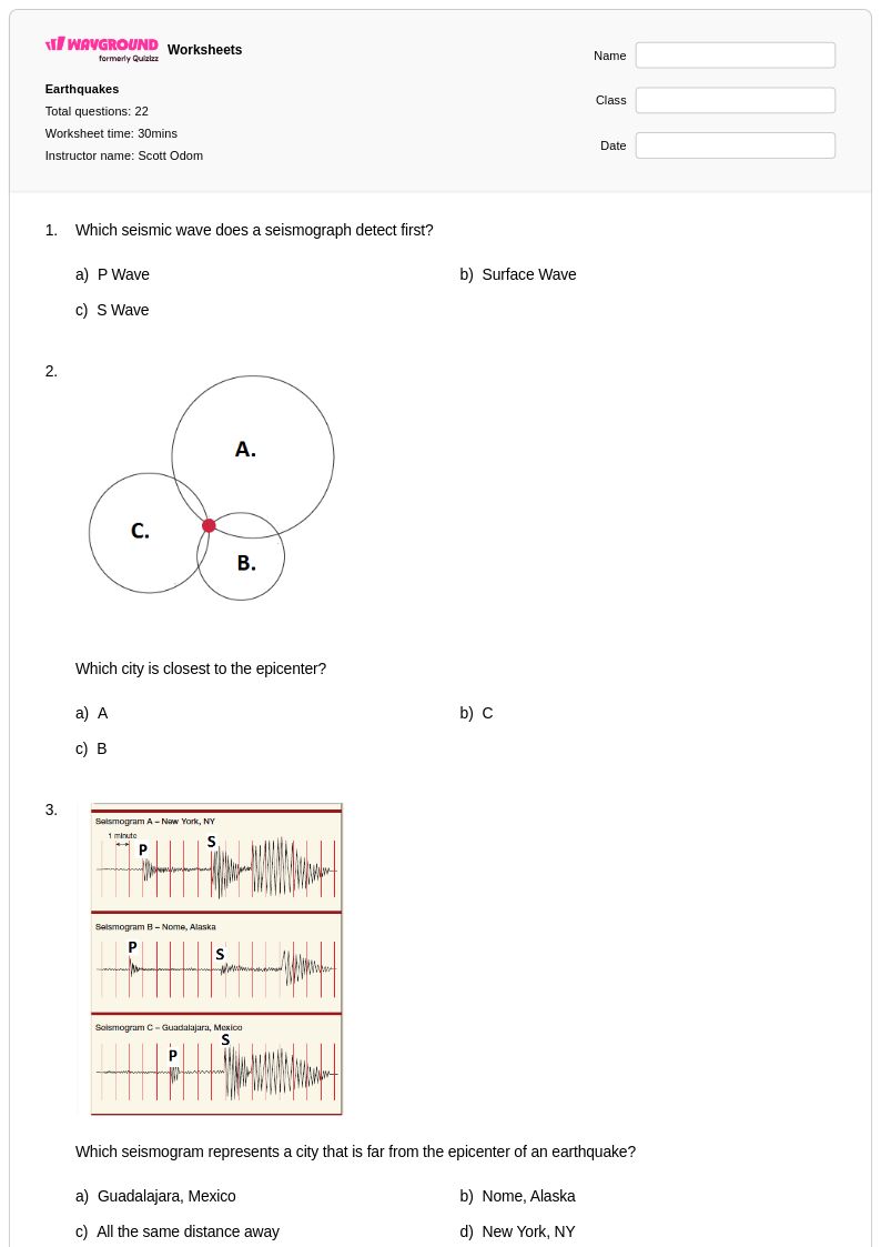
Teaching epicenter location starts with building student understanding of how seismic waves travel at different speeds and are recorded at multiple seismograph stations. Once students can read P-wave and S-wave arrival times from seismograms, introduce travel-time graphs to calculate the distance from each station to the epicenter. The triangulation method — drawing circles scaled to each station's distance and identifying the single intersection point — is the core skill students need to practice repeatedly with varied data sets before it becomes intuitive.
What exercises help students practice triangulation for locating earthquakes?
The most effective practice involves multi-station triangulation problems where students use travel-time graphs to calculate distances from at least three seismograph stations and then plot scaled circles on a map to find the epicenter. Varying the number of stations, the complexity of the seismograms, and the geographic scale of the map keeps practice meaningful and progressively challenging. Simulated real-world scenarios that use actual seismograph data from historical earthquakes add authenticity and help students connect classroom skills to professional seismology.
What common mistakes do students make when locating earthquake epicenters?
The most frequent error is misreading the time difference between P-wave and S-wave arrivals on a seismogram, which cascades into an incorrect distance calculation and a misplaced epicenter. Students also commonly confuse the epicenter with the focus, or hypocenter, and mix up which wave type arrives first. A third persistent mistake is drawing triangulation circles at the wrong scale on a map, so explicit practice with scale conversion and circle-drawing tools is essential before students attempt full triangulation problems independently.
How do I use Wayground's locating earthquakes worksheets in my classroom?
Wayground's locating earthquakes worksheets are available as printable PDFs for traditional classroom use and in digital formats for technology-integrated environments, so you can deploy them as paper handouts, assigned digital work, or hosted quizzes directly on the Wayground platform. Each worksheet includes a detailed answer key, making them practical for guided instruction, independent practice, or homework without additional preparation. Digital hosting on Wayground also allows you to apply student-level accommodations such as extended time or read-aloud support for students who need them.
How do I differentiate earthquake location activities for students at different skill levels?
For students who are still developing foundational skills, simplify triangulation exercises by reducing the seismogram complexity and providing partially completed travel-time graphs so they can focus on the mapping step. Advanced students benefit from problems that increase the number of recording stations, introduce measurement uncertainty, or ask them to evaluate why three circles may not intersect at a perfect single point. On Wayground, teachers can also apply accommodations such as reduced answer choices or read-aloud support to individual students without disrupting the experience for the rest of the class.
How do P-waves and S-waves help scientists determine where an earthquake occurred?
P-waves (primary waves) travel faster than S-waves (secondary waves), so they always arrive at a seismograph station first. The time gap between their arrivals is directly proportional to the distance between the station and the earthquake source, and seismologists use travel-time graphs to convert that gap into a distance measurement. By repeating this calculation for at least three stations and applying triangulation, scientists can pinpoint the epicenter as the surface location directly above where the earthquake originated.