Free Printable Virginia Regions Worksheets for Class 2
Class 2 Virginia Regions worksheets and printables help students explore the distinct geographical areas of Virginia through engaging practice problems, free PDF resources, and comprehensive answer keys for effective learning.
Explore printable Virginia Regions worksheets for Class 2
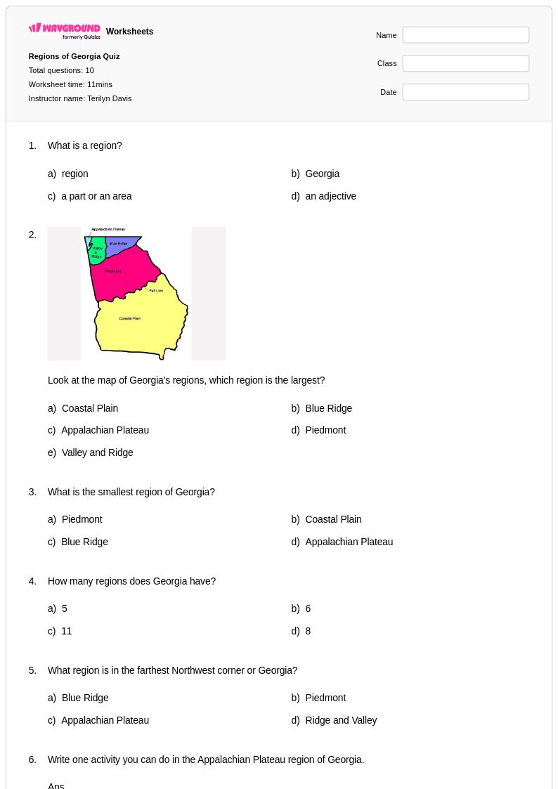
Virginia Regions worksheets for Class 2 students available through Wayground provide young learners with engaging opportunities to explore the distinct geographic areas that make up the Commonwealth of Virginia. These carefully crafted educational materials help second-grade students develop foundational geography skills by identifying and comparing Virginia's five major regions: the Coastal Plain (Tidewater), Piedmont, Blue Ridge Mountains, Valley and Ridge, and Appalachian Plateau. Each worksheet collection includes comprehensive practice problems that guide students through recognizing regional characteristics, understanding how geography influences human settlement patterns, and connecting physical features to economic activities within each area. The free printable resources come complete with detailed answer keys, allowing teachers to efficiently assess student comprehension while supporting independent learning through structured pdf materials that can be easily distributed and completed both in classroom settings and at home.
Wayground's extensive collection of teacher-created Virginia Regions materials draws from millions of high-quality educational resources specifically designed to meet Class 2 social studies curriculum requirements. The platform's advanced search and filtering capabilities enable educators to quickly locate worksheets that align with state standards while providing differentiation tools to accommodate diverse learning needs within their classrooms. Teachers can seamlessly customize these printable and digital materials to support targeted skill practice, whether implementing whole-class instruction, small group remediation, or individual enrichment activities. The flexible pdf format ensures accessibility across various teaching environments, while the comprehensive scope of available resources supports thorough lesson planning and enables educators to scaffold geographic concepts effectively, helping young students build lasting connections between Virginia's physical features and the communities that call each region home.
FAQs
How do I teach Virginia's five geographic regions to elementary or middle school students?
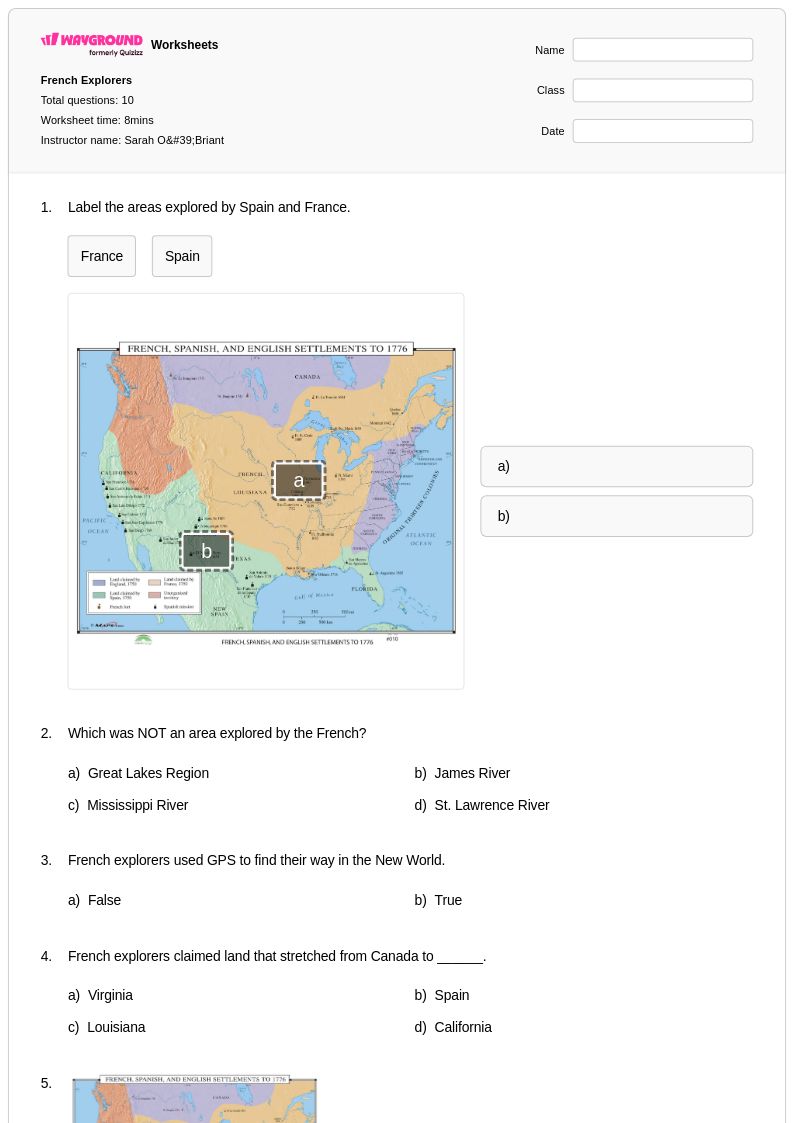
Start by anchoring each region to a memorable physical feature — the flat wetlands of the Coastal Plain (Tidewater), the rolling hills of the Piedmont, the forested ridges of the Blue Ridge Mountains, the parallel valleys of the Valley and Ridge, and the rugged plateau of the Appalachian region. From there, build outward to how each region's landforms shaped settlement patterns, economic activity, and natural resources. Using labeled maps alongside region comparison charts helps students visualize how geography transitions from east to west across the Commonwealth.
What exercises help students practice identifying Virginia's geographic regions?
Map labeling activities — where students identify and color each of Virginia's five regions — are among the most effective practice tools because they build spatial literacy alongside content knowledge. Pairing these with characteristic-matching tasks, where students connect landforms, climate features, and economic activities to each region, reinforces comprehension beyond simple memorization. Short constructed-response prompts asking students to explain how physical geography influences human settlement in a specific region push deeper analytical thinking.
What mistakes do students commonly make when learning about Virginia's regions?
A frequent error is conflating the Blue Ridge Mountains with the Valley and Ridge region — students often treat all mountainous terrain in western Virginia as a single undifferentiated area. Another common misconception is assuming the Coastal Plain is entirely flat and uniform, when in fact it includes significant river systems and tidal wetlands that shape both its geography and its historical settlement. Students also tend to oversimplify economic activity by region, not recognizing that industries like agriculture and tourism can span multiple regions for different geographic reasons.
How can I use Virginia Regions worksheets to differentiate instruction for mixed-ability classrooms?
Virginia Regions worksheets on Wayground support differentiation through built-in accommodation tools that can be applied at the individual student level. Teachers can enable reduced answer choices for students who need lower cognitive load, turn on Read Aloud for struggling readers, or grant extended time on a per-student basis — all without alerting the rest of the class. These settings are reusable across sessions, making it practical to maintain consistent accommodations for IEP or 504 students throughout a geography unit.
How do I use Virginia Regions worksheets from Wayground in my classroom?
Virginia Regions worksheets on Wayground are available as printable PDFs for traditional classroom use and in digital formats for technology-integrated or hybrid environments. Teachers can assign digital versions directly to students and optionally host them as a quiz through the Wayground platform for built-in scoring and progress tracking. All worksheets include answer keys, reducing prep time and making them easy to use for independent practice, guided instruction, or assessment review.
How do Virginia's geographic regions connect to economic activities students need to understand?
Each of Virginia's five regions has historically supported distinct economic activities tied directly to its physical geography. The Coastal Plain's rivers and Chesapeake Bay proximity drove early colonial trade and fishing industries, while the Piedmont's fertile soil supported agriculture and later manufacturing. The Blue Ridge, Valley and Ridge, and Appalachian Plateau regions are associated with timber, mining, and tourism — connections students need to understand not just as facts, but as examples of how physical geography shapes human economic decisions.