wayground logo

Free Printable Worksheets

Font size

S
M
L
XL
Worksheets

Plate Tec/ Topography Review

Total questions: 90

Worksheet time: 3585secs

Name
Class
Date
1.
What is the profile view to Topographic Map #1? 
a)
A
b)
B
c)
C
d)
D
2.

What is the elevation of point B? (Contour interval is 100m)

a)

800 ft

b)

850 ft

c)

900 ft

d)

1000 ft

3.
What is the elevation of Y?
a)
Between 120-140 meters
b)
Between 100-120 meters
c)
Between 140-160 meters
d)
Between 80-100 meters
4.
What is the profile view to Topographic Map #2?
a)
B
b)
C
c)
D
d)
E
5.
What is the elevation of the peak of the small island on the left side?
a)
About 20 meters
b)
About 40 meters
c)
About 60 meters
d)
About 200 meters
6.
What feature is formed at B?
a)
river
b)
rift valley
c)
sink hole
d)
mountain
7.
A mountaineer is planning an expedition. He wants to follow the easiest possible path, which means he needs to find the most gentle slope up the mountain. Which route should the mountaineer choose?
a)
Route A
b)
Route B
c)
 Route C
d)
Route D
8.
What do close contour lines represent on a map?
a)
waterfall
b)
steep area
c)
gradual area
d)
river
9.
What do contour lines that are farther apart represent?
a)
waterfall
b)
steep area
c)
gentle slope
d)
river
10.
In which direction is Mill River flowing?
a)
Southeast
b)
Southwest
c)
Northeast
d)
Northwest
11.
What feature is at the arrow?
a)
volcano
b)
mountain
c)
cliff
d)
river
12.
Provided is a topographic map of a hill with contour lines drawn showing elevation in meters.
The steepest slope on this hill can be found on the side that is facing which direction?
a)
Southwest
b)
Northeast
c)
Northwest
d)
Southeast
13.
What is the change in elevation from point X to the top of the hill in the topographic map shown?
a)
303 m
b)
203 m
c)
250 m
d)
253 m
14.
What is the most likely elevation of the mountain peak? (Contour interval is 100 m)
a)
1550  meters
b)
 1652 meters
c)
1500 meters
d)
1700 meters
15.
Determine the contour interval
a)
10 m
b)
20 m
c)
50 m
d)
100 m
16.
Determine the contour interval:
a)
5 m
b)
10 m
c)
15 m
d)
20 m
17.
Which direction is the river flowing?
a)
north
b)
south
c)
east 
d)
west
18.
Contour lines that are very far apart indicate the landscape is _____________
a)
gentle/gradual
b)
steep
c)
a forest
d)
a swamp
19.
V-shaped contour lines show a
a)
mountain top
b)
stream valley
c)
depression
d)
steep slope
20.
How many mountain tops does this map have?
a)
one
b)
two
c)
three
d)
four
21.
How many mountain peaks are represented?
a)
one
b)
two
c)
three
d)
four
22.
What is this symbol?
a)
mountain
b)
depression or sinkhole
c)
cave
d)
railroad central
23.
Determine the contour interval:
a)
5 m
b)
10 m
c)
15 m
d)
20 m
24.
Lines on a topographic map that connect lines of equal elevation:
a)
contour lines
b)
contour interval
c)
index contour
d)
contour loops 
25.
What does this image represent?
a)
mountain
b)
depression or sinkhole
c)
beaches
d)
cave
26.

Match #5 to its profile view (Letter)

a)

C

b)

D

c)

E

d)

F

27.

Match #6 to its profile view (Letter)

a)

A

b)

B

c)

D

d)

E

28.
The bold lines that appear on the map every 5th contour line with the exact elevation written on it is the ______________________
a)
Index Contour line
b)
Contour interval
c)
Relief
d)
Slope
29.

Match #4 to its profile view (Letter)

a)

C

b)

D

c)

E

d)

F

30.
What could be the lowest elevation in the depression?
a)
50 feet
b)
41 feet
c)
60 feet
d)
51 feet
31.
Find the contour interval:
a)
5 ft
b)
10 ft
c)
20 ft
d)
25 ft
32.
What is the elevation of point B?
a)
800 ft
b)
850 ft
c)
900 ft
d)
1000 ft
33.
What are the two types of crust?
a)
continental and oceanic
b)
ocean and basin
c)
lower and upper
d)
thick and thin
34.
The Great Rift Valley in Africa and the Mid-Atlantic Ridge were both created by this type of plate boundary. 
a)
divergent
b)
convergent
c)
transform
d)
subduction
35.
A __________ shows relationship between distance on map to distance on Earth
a)
legend
b)
compass
c)

direction

d)
scale
36.
What is a contour interval on a topographic map?
a)
the change in elevation from one line to another
b)
the amount of space it takes to climb the mountain
c)
the shape of the land
d)
how long it takes to walk the land
37.
What is the elevation at sea level?
a)
0
b)
100m
c)
20m
d)
3000m
38.
What is the change in elevation from point X to the top of the hill in the topographic map shown?
a)
303 m
b)
203 m
c)
250 m
d)
253 m
39.

What do we identify the boundary as when a tectonic plate collides with another tectonic plate?

a)

Convergent Boundary

b)

Divergent Boundary

c)

Transform Boundary

d)

Plate Boundary

40.

What is the main cause for tectonic plates movement on the Earth's crust?

a)

Energy from the Sun

b)

Magnetic Pole Reversal

c)

Convection currents in the mantle

d)

Faults in Mountain Ranges

41.

When two plates collide, they can either create folded mountains or subduction zones (with volcanoes). What type of boundary can be found here?

a)

Plate

b)

Divergent

c)

Convergent

d)

Transform

42.

Two plates are sliding passed each other in a Transform Boundary. One event that can happen during this is what?

a)

Earthquake

b)

Volcano Eruption

c)

Tornado

d)

Mountain Building

43.

When there is a divergent boundary between two plates, this can best be described as the plates...

a)

Pull apart

b)

Come together

c)

Slide past each other

d)

subducting

44.

Which of the following is the name of the ancient supercontinent formed 28 Million Years ago.

a)

Pangaea

b)

Gondwanda

c)

Laurasia

d)

Neverland

45.

Which of the following is NOT evidence to support the theory of plate tectonics?

a)

Fossils of animals and plants that cannot travel through air or by sea

b)

Mountain samples that matched (exact layers and composition)

c)

Puzzle piece continents that seemed to fit perfectly together

d)

Sand Erosion of the beaches was the same
46.

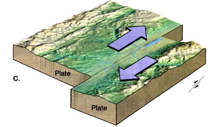
Like the San Andreas Fault, these two plates are sliding passed each other. This is a _________ plate boundary.

a)

Transform

b)

Convergent

c)

Divergent

d)

Plate

47.

The theory that says Earth's continents once made up an ancient supercontinent, and have been drifting apart ever since, is called the theory of...

a)

Pangea

b)

Plate Tectonics

c)

Natural Selection

d)

Gravity

48.

Islands like Hawaii can form from magma which is pushed up at a __________ plate boundary when one oceanic plate subducts under another oceanic plate.

a)

Divergent

b)

Convergent

c)

Transform

49.

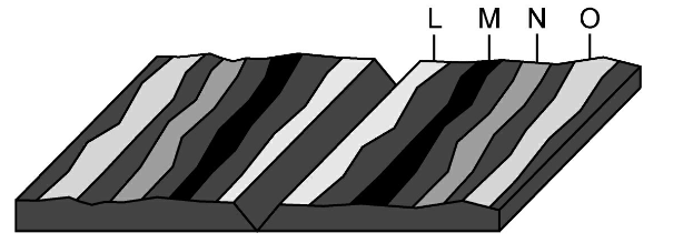
In 1960 when Hess & Vines surveyed the ocean floor they found that some rocks were older than others based on how far they were from the mid-ocean ridge. Where would the oldest rock be found?

a)

L

b)

M

c)

N

d)

O

50.

If the magma that comes up under the ocean cools to make new rock, why do we not have more land, or surface area of land, than we have now?

a)

Crust is destroyed at the same time it is created

b)

New crust is underwater where it sinks

c)

New crust breaks more easily than old crust

51.

Folded mountains are created when ____________________ and the plates create a stacking/ripple effect with the crust.

a)

Two continental plates collide

b)

Two oceanic plates pull apart

c)

An Oceanic plate subducts under a Continental Plate

d)

Two continental plates pull apart

52.
The part of the earth that includes the crust and the upper mantle and is split into tectonic plates is the
a)
lithosphere
b)
 crust
c)
asthenosphere
d)
mantle
53.
Many scientists think hot plastic-like rock in the mantle is forced upward toward the surface, cools, and sinks.  This process is called a(n) _________.
a)
earthquake
b)
convergent boundary
c)
volcano
d)
convection current
54.

Which of these objects would most accurately be a good model to describe Earth and its layers? (think about how the layers look and what they're made of)

a)
b)
c)
d)
55.

Which layer of the Earth is the driving force for the plate tectonic movement?

a)

Crust

b)

Inner Core

c)

Asthenosphere

d)

Outer Core

56.

If basalt is a very dense mineral (rock) and things like sediment and metamorphic rock are less dense, which type of crust is the most dense?

a)

Continental Crust

b)

Oceanic Crust

c)

Stuffed Crust

d)

Thin Crust

57.

Which combination of layers helps create the magnetic field around the Earth which protects us?

a)

Crust and Lithosphere

b)

Outer core and Asthenosphere

c)

Inner core and Outer core

d)

Mantle and Outer core

58.

When two continental plates diverge, what land form does this create?

a)

Folded mountains (like the Himalayas)

b)

Mid-ocean ridges (like the Mid- Atlantic Ridge)

c)

Volcanoes (like Hawaii)

d)

Rift Valleys (like the East African Rift Valley)

59.

Which locations is experiencing Subduction?

a)

A

b)

B

c)

C

d)

D

60.

Which type of plate boundary relationship creates volcanic island arcs?

a)

Oceanic<---- ------>Oceanic

b)

Oceanic -------><--------Oceanic

c)

Continental<--------- ----------> Continental

d)

Continental----------><-----------Oceanic

61.

What type of plate boundary relationship would create something like the Himalayan Mountain range?

a)

Continental<------- ---------> Continental

b)

Oceanic <---------- -----------> Continental

c)

Continental------------><-----------Continental

d)

Oceanic------------><----------Oceanic

62.

What type of plate boundary relationship would create a land form like the Mid- Atlantic Ridge?

a)

Oceanic<-------- ---------->Oceanic

b)

Oceanic---------><-----------Oceanic

c)

Continental---------><---------Continental

d)

Oceanic----------> ----------->Continental

63.

Since the plates only move about as fast as your fingernails grow it would take millions of year to notice an extreme change. As the Mid-Atlantic Ridge creates new crust, what would happen to North America over time?

a)

It will collide with Europe

b)

It will be subducted into the mantle and be destroyed

c)

It will collide with the African plate

d)

It will go over the Pacific plate and collide with the eastern Eurasian plate

64.
The tectonic plates float on the 
a)
lithosphere
b)
lower mantle
c)
outer core
d)
asthenosphere
65.
The part of the earth that includes the crust and the upper mantle and is split into tectonic plates is the
a)
lithosphere
b)
 crust
c)
asthenosphere
d)
mantle
66.
The hottest layer
a)
crust
b)
inner core
c)
mantle
d)
outer core
67.
The coolest layer
a)
crust
b)
inner core
c)
mantle
d)
outer core
68.
The thinest layer
a)
crust
b)
inner core
c)
mantle
d)
outer core
69.
The thickest layer
a)
crust
b)
inner core
c)
mantle
d)
outer core
70.
The least dense layer
a)
crust
b)
inner core
c)
mantle
d)
outer core
71.
The most dense layer
a)
crust
b)
inner core
c)
mantle
d)
outer core
72.
This layer is a mix between solid and liquid
a)
crust
b)
inner core
c)
mantle
d)
outer core
73.
Supporting Evidence: fossils, continent shape, landforms
a)
Continental Drift
b)
Seafloor Spreading
c)
Plate Tectonics
74.
Supporting Evidence: subduction, earthquakes, volcanoes, Mid-Atlantic Ridge, older theories
a)
Continental Drift
b)
Seafloor Spreading
c)
Plate Tectonics
75.
Supporting Evidence: discovery of Mid-Atlantic Ridge, core rock samples showing older rocks the farther that you get from the mid ocean ridge
a)
Continental Drift
b)
Seafloor Spreading
c)
Plate Tectonics
76.
The circular pattern of heating, rising, cooling, sinking of magma in the mantle causing tectonic plates to move.
a)
Plate Tectonics
b)
Convection Currents
c)
Pangaea
d)
Subduction
77.
Volcanoes are most often formed at this boundary.
a)
Divergent
b)
Convergent
c)
Normal
d)
Transform
78.
The Mid-Atlantic Ridge is formed at this boundary.
a)
Divergent
b)
Convergent
c)
Normal
d)
Transform
79.
Continental crust is more dense than oceanic crust.
a)
True
b)
False
80.
Hot spots are volcanically active areas that are not near tectonic plate boundaries.
a)
True
b)
False
81.
What type of boundary is the SAN ANDREAS FAULT on?
a)
Covergent
b)
Transformers
c)
Divergent
d)
Transform
82.
Islands can from from magma which is pushed up at a __________ plate boundary
a)
Divergent
b)
Convergent
c)
Transform
83.
Mountains are created when....
a)
Two continental plates collide
b)
Two oceanic plates pull apart
c)
An Oceanic plate subducts under a Continental Plate
d)
Two continental plates pull apart
84.
Transform boundaries are most likely to produce what phenomenon?
a)
volcanoes
b)
deep sea trenches
c)
underwater mountain ranges
d)
earthquakes
85.
A boy touches a hot cup and burns his finger.  This is an example of
a)
Radiation
b)
Conduction
c)
Convection
d)
Convection Current
86.
A Plate Boundary where two plates move toward each other is called
a)
Convergent Boundary
b)
Divergent Boundary
c)
Transform Boundary
d)
Subduction
87.
What is the difference between the lithosphere and asthenosphere that makes up the mantle?
a)
The lithosphere is ismade of dense solid meal whle the asthenosphere is made of liquid molten metal
b)
The lithosphere is a mixture of gasses while the asthenosphere is made of solid rock
c)
The lithosphere is molten rock that moves while the asthenosphere is ridid and thin
d)
The lithosphere is made of solid rock while the asthenosphere is more flexible hot rock that moves.
88.
_______________ Currents within the mantle cause the earth's plates to move and shift s molten material rises and falls due to density and gravity
a)
Convection
b)
Radiation
c)
Conduction
d)
Wind
89.
Divergent Plate movement can create
a)
Convection Currents
b)
Conduction
c)
Mountains
d)
Rifts and ocean ridges
90.
The movement of metals within the earth's outer core cause a ____________________________ that is detectable on the earth's surface using a compass
a)
Gravitational Pull
b)
Volcanic Eruption
c)
Magnetic field
d)
Convection Current