
 Worksheets
7th Grade Test 1 Review
Total questions: 76
Worksheet time: 1hrs 1mins
Name
Class
Date
1.

How many geographic regions are located in Texas?
a)
6
b)
2
c)
4
d)
1
2.

What are the names of the geographic regions of Texas?
a)
Plains, Mountains, Basins, Coast
b)
Mountains and Valleys, Central Plains, Great Plains, Coastal Plains
c)
Mountains and Basins, North Central Plains, Great Plains, Ocean Plains
d)
Coastal Plains, Great Plains, Mountains and Basins, North Central Plains
3.

Name the geographic region highlighted on the map.
a)
Coastal Plains
b)
Mountains and Basins
c)
North Central Plains
d)
Great Plains
4.

Name the geographic region highlighted on the map.
a)
Coastal Plains
b)
North Central Plains
c)
Great Plains
d)
Mountains and Basins
5.

Name the geographic region highlighted on the map.
a)
Mountains and Basins
b)
Great Plains
c)
North Central Plains
d)
Coastal Plains
6.

Name the geographic region highlighted on the map.
a)
Coastal Plains
b)
Great Plains
c)
Mountains and Basins
d)
North Central Plains
7.

Which Texas geographic region is the largest?
a)
Mountains and Basins
b)
Coastal Plains
c)
North Central Plains
d)
Great Plains
8.

How many regions of Texas have plains as a major geographical feature?
a)
1
b)
2
c)
3
d)
4
9.

Which Texas region has beaches, pine forests, and plains?
a)
Mountains and Basins
b)
Coastal Plains
c)
Great Plains
d)
North Central Plains
10.

Which region of Texas covers the least amount of land?
a)
Coastal Plains
b)
Mountains and Basins
c)
Great Plains
d)
North Central Plains
11.

This region of Texas has the smallest population and fewest towns.
a)
North Central Plains
b)
Mountains and Basins
c)
Central Plains
d)
Coastal Plains
12.

Which two regions have cacti as a primary plant?
a)
Coastal Plains & Mountains and Basins
b)
North Central Plains & Great Plains
c)
North Central Plains & Great Plains
d)
Mountains and Basins & Great Plains
13.

Beaches
a)
Great Plains
b)
North Central Plains
c)
Coastal Plains
d)
Mountains and Basins
14.
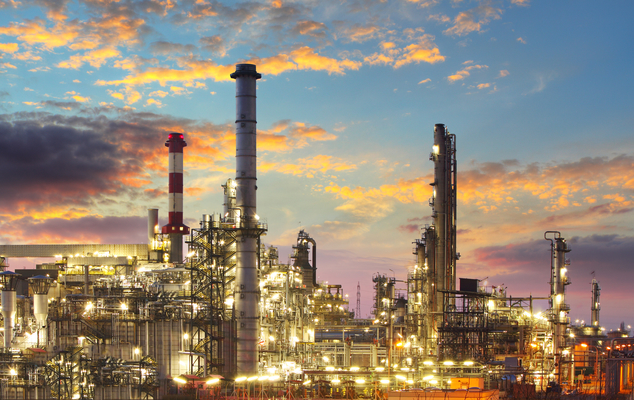
Petrochemical
a)
Great Plains
b)
North Central Plains
c)
Coastal Plains
d)
Mountains and Basins
15.
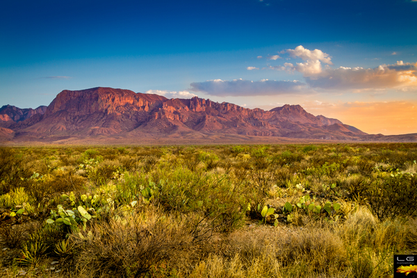
only mountains inTexas
a)
Great Plains
b)
North Central Plains
c)
Coastal Plains
d)
Mountains and Basins
16.

a)
Great Plains
b)
North Central Plains
c)
Coastal Plains
d)
Mountains and Basins
17.

a)
Great Plains
b)
North Central Plains
c)
Coastal Plains
d)
Mountains and Basins
18.

Oil out West
a)
Great Plains
b)
North Central Plains
c)
Coastal Plains
d)
Mountains and Basins
19.

What state creates the border of Texas to the northwest?
a)
New Mexico
b)
Arizona
c)
Colorado
d)
Arkansas
20.

What river creates the border between Texas and Oklahoma?
a)
Rio Grande
b)
Red River
c)
Sabine River
d)
Trinity River
21.

The Rio Grande creates the border between Texas and.....
a)
New Mexico
b)
United States
c)
Mexico
d)
Canada
22.

The northeast portion of Texas borders....
a)
New Mexico
b)
Oklahoma
c)
Arkansas
d)
Louisiana
23.

What large body of water borders Texas to the southeast?
a)
Gulf of Mexico
b)
Caribbean Sea
c)
Atlantic Ocean
d)
Gulf of California
24.

Which state does NOT border Texas?
a)
Arkansas
b)
New Mexico
c)
Arizona
d)
Oklahoma
25.

Identify the area
a)
Red River
b)
Sabine River
c)
Rio Grande
d)
Gulf of Mexico
26.

Identify the area
a)
Red River
b)
Sabine River
c)
Rio Grande
d)
Gulf of Mexico
27.

Identify the area
a)
Red River
b)
Sabine River
c)
Gulf of Mexico
d)
Rio Grande
28.

Identify the area
a)
Arkansas
b)
Oklahoma
c)
New Mexico
d)
Mexico
29.

Identify the area
a)
Arkansas
b)
Oklahoma
c)
New Mexico
d)
Mexico
30.

Identify the area
a)
Mexico
b)
Oklahoma
c)
Arkansas
d)
Louisiana
31.

Identify the area
a)
Mexico
b)
New Mexico
c)
Oklahoma
d)
Arkansas
32.

Identify the area
a)
Louisiana
b)
New Mexico
c)
Mexico
d)
Arkansas
33.

Which of the following rivers separates Texas from the country of Mexico?
a)
Rio Grande River
b)
Red River
c)
Sabine River
d)
Nueces River
34.

Which of these Texas cities is located in a place where hurricanes sometimes strike?
a)
El Paso
b)
Amarillo
c)
Lubbock
d)
Galveston
35.

A level area higher than the surrounding land.
a)
escarpment
b)
plateau
c)
basin
36.

A place where groundwater comes to the surface.
a)
groundwater
b)
spring
c)
barrier island
37.

A natural or artificial lake used to reserve or store water.
a)
conserve
b)
drought
c)
reservoir
38.

The pattern of weather in a place over a long period of time.
a)
weather
b)
climate
c)
precipitation
39.

The condition of the air at one time and place, including temperature, precipitation, and wind.
a)
weather
b)
climate
c)
precipitation
40.

A fierce swirling funnel of wind created by thunderstorms.
a)
blizzard
b)
norther
c)
tornado
41.

A storm with high winds and lots of snow.
a)
blizzard
b)
norther
c)
tornado
42.

Moisture that falls to the ground as rain, snow, sleet, or hail.
a)
weather
b)
climate
c)
precipitation
43.

What region has a hot and humid climate and is likely to have tropical storms
a)
Coastal Plains
b)
Mountains and Basins
c)
Central Plains
d)
Great Plains
44.

Which Texas region is most likely to have tornadoes?
a)
Great Plains
b)
Coastal Plains
c)
Mountains and Basins
d)
Central Plains
45.

What is the capitol of Texas?
a)
Dallas
b)
Houston
c)
San Antonio
d)
Austin
46.
Culture
a)
The language of a particular group.
b)
the traditions, beliefs,language, and arts of a particular group,
c)
The beliefs of a particular group.
d)
The arts of a particular group.
47.

Identify the area
a)
Mexico
b)
Spain
c)
France
d)
Texas
48.
Which of the following Native American cultures did not use tepees?
a)
Tonkawa
b)
Jumanos
c)
Comanche
d)
Apache
49.
Which of the following tribes were NOT nomadic?
a)
Jumanos
b)
Comanches
c)
Tonkawas
d)
Apaches
50.
Which food source did the Plains Indians depend on?
a)
Deer
b)
Bear
c)
Fish
d)
Buffalo
51.
What was the main crop of the Caddo
a)
Corn
b)
Wheat
c)
Oil
d)
Cotton
52.
What region is the Puebloan culture from?
a)
Mountains and Basins
b)
Great Plains
c)
Central Plains
d)
Coastal Plains
53.

The type of house in this picture is from what culture?
a)
Puebloan
b)
Plains
c)
Gulf (Karankawa)
d)
South Eastern (Caddo)
54.

The European wiped out the Karankawa and Jumano tribes with ______________.
a)
trading and spying
b)
disease and fighting
c)
fighting and trading
d)
foods and trading
55.
Which tribe used adobe to build their homes?
a)
Jumano
b)
Caddo
c)
Karankawa
d)
Waco
56.
The area of Mexico and Central South America that scientists believe Natives traveled to and successfully farmed this region.
a)
Mesopotamia
b)
South America
c)
Mesoamerica
d)
North America
57.
Any tangible thing that can be used to study people of the past(human remains, ruins, pottery, cave art, etc.).
a)
Artifacts
b)
Maize
c)
Mitotes
d)
Grass Huts
58.
People who travel from place to place and have no permanent homes.
a)
Wanderers
b)
Nomads
c)
Buffalo Hunters
d)
Zombies
59.

What house is being displayed and what type of people used this?
a)
Adobe and Western Plains indians
b)
Teepees and Nomads
c)
Grass Huts and Southeastern Indians
d)
Brick house and Choctaw
60.
What crop was most important to Natives and what was it's Native name?
a)
Squash-Zucchini
b)
Corn-Succotash
c)
Cotton-Cloth
d)
Corn-Maize
61.
People who hunt animals and use every part of it (food, clothing, jewelry, etc) and gathers vegetation(plants).
a)
Hunters
b)
Hunters and Gatherers
c)
Bush People
d)
Gatherers
62.
A pictorial representation of important things, events, and people in the Native American culture are called.
a)
Artifacts
b)
Cave Art
c)
Tattoos
d)
Societies
63.
Scientists who study human remains and artifacts to learn how people lived
a)
Archaeologists
b)
Anthropologists
c)
Architects
d)
Agriculturists
64.
What landform do Jumano rely on to overflow and fill their fields with water to help their crops grow.
a)
Trinity River
b)
San Antonio River
c)
Sabine River
d)
Rio Grande River
65.
Some of us were nomads and moved onto the plains of western and central TX and hunted buffalo before we died off because of European disease, drought or attacks from the Apache.
a)
Jumano
b)
Caddo
c)
Tonkawa
d)
Paleo
66.
This animal was important to the Natives living in the Plains because of it's ability to run fast and how it helped them become outstanding buffalo hunters and warriors.
a)
Mule
b)
Horse
c)
Mammoth
d)
Buffalo
67.
This group of Natives fought to keep their land but were moved onto a Reservation in Oklahoma after they lost the Buffalo heard and horses that allowed them to prosper in the plains area.
a)
Comanche
b)
Kiowa
c)
Choctaw
d)
Caddo
68.
The continents of North American and _______were connected over 25,000 year ago with the Bering Land Bridge.
a)
South America
b)
Asia
c)
Europe
d)
Africa
69.
Which tribe used adobe to build their homes?
a)
Jumano
b)
Caddo
c)
Karankawa
d)
Waco
70.
To be nomadic, means to stay in one place
a)
True
b)
False
71.
Who brought the horses the Comanche caught and tamed?
a)
English
b)
French
c)
The military men
d)
Spanish
72.
Comanche were _______________ because they traveled around following the buffalo.
a)
sedentary
b)
semi-sedentary
c)
nomadic
73.
The Jumano and Tigua Indian homes were built from _____________
a)
grass
b)
adobe
c)
sticks
d)
animal hide
74.
Native Americans NO longer celebrate their culture
a)
true
b)
false
75.
Jumano farmed by digging _________________ ditches to water their crops.
a)
shallow
b)
heavy
c)
irrigation
76.
What region did the Jumano and Tigua Native Americans live in?
a)
Coastal Plains
b)
Mountains and Basins
c)
Great Plains
d)
Central Plains
100 %

