wayground logo

Free Printable Worksheets

Font size

S
M
L
XL
Worksheets

Weather Symbols, Global Winds, Extreme Weather

Total questions: 74

Worksheet time: 1hrs 28mins

Name
Class
Date
1.

What is the source of all the energy in our atmosphere?

a)

Wind

b)

Sun

c)

Moon

d)

Food

2.

What is the pressure on the Equator? why?

a)

High Pressure, because the air is hot so it sinks pushing on the Earth

b)

High Pressure, because the air is hot so it rises, rising air has more pressure

c)

Low pressure, because the air is hot it sinks pushing on the Earth

d)

Low Pressure, because the air is hot it rises, rising air has less pressure

3.

What pressure at the Poles? why? *

a)

High Pressure, because the air is cold so it sinks pushing on the Earth

b)

High Pressure, because the air is cold so it sinks, sinking air has less pressure

c)

Low pressure, because the air is cold it sinks pushing on the Earth

d)

Low Pressure, because the air is cold it sink, sinking air has less pressure

4.

Steady winds the blow between the equator and 30 latitude north and south are known as the ______.

a)

doldrums

b)

Jet Stream

c)

polar easterlies

d)

Trade Winds

5.

Winds that occur between 60 and 90 degrees north and south latitude are known as the ________. *

a)

trade winds

b)

westerlies

c)

easterlies

d)

jet stream

6.

The US is under what global wind belt? *

a)

Westerlies

b)

Trade WInds

c)

Polar Easterlies

d)

Sea Breeze

7.

Wind always flows from

a)

High to low

b)

Low to high

8.

Which way do weather systems in the US move? *

a)

East to West

b)

West to East

9.

What type of weather does a Low Pressure system bring? Why? *

a)

Cloudy weather, because the air is rising so clouds DO form

b)

Clear weather, because the air is sinking so NO clouds form

c)

Clear weather, because the air is rising so NO clouds form

d)

Cloudy weather, because the air is sinking so clouds DO form

10.

What type of weather does a High Pressure system bring? Why? *

a)

Cloudy weather, because the air is sinking so clouds DO form

b)

Cloudy weather, because the air is rising so clouds DON'T form

c)

Clear weather, because the air is sinking so clouds DON'T form

d)

Clear weather, because the air is rising so clouds DO form

11.

The flow of air caused by ________ creates distinct wind patterns on Earth's surface, known as the global winds.

a)

temperature diferences

b)

the ozone layer

c)

magnetic fields

d)

the jet streams

12.

Which of the following is NOT a global wind belt? *

a)

Prevailing Westerlies

b)

Polar Easterlies

c)

Trade Winds

d)

Horse Latitudes

13.
What characteristics are used to classify air masses?
a)
temperature and humidity
b)
pressure and temperature
c)
latitude and longitude
d)
wind speed and location 
14.
When a warm air mass is trapped between two cooler air masses, it is called a/an - 
a)
warm front
b)
cold front
c)
occluded front
d)
stationary front
15.
Air travels
a)
from high pressure to low pressure
b)
from low pressure to high pressue
16.
When a warm air mass gently slides on top of a cold air mass, and you have drizzly rain and then warmer weather, what type of front is it?
a)
warm front
b)
cold front
c)
occluded front
d)
stationary front
17.
What type of weather does a high pressure system bring?
a)
Stormy weather
b)
Clear skies, little rain
18.
What types of air masses form over oceans?
a)
Maritime
b)
Continental
c)
Polar
d)
Tropical
19.
What's the humidity and temperature of a continental tropical air mass?
a)
Wet and cold
b)
Dry and warm
c)
Wet and warm
d)
Dry and cold
20.
What's the humidity and temperature of a maritime tropical air mass?
a)
Wet and cold
b)
Dry and warm
c)
Wet and warm
d)
Dry and cold
21.
A wet and cold air mass would be a...
a)
Maritime polar
b)
Continental polar
c)
Maritime tropical
d)
Continental tropical
22.
A dry and cold air mass would be...
a)
Maritime polar
b)
Continental polar
c)
Maritime tropical
d)
Continental tropical
23.
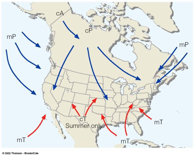
Which abbreviation of an air mass can be identified as dry and hot?
a)
cP
b)
mP
c)
cT
d)
mT
24.
Which abbreviation of an air mass can be identified as cold and moist?
a)
cP
b)
mP
c)
cT
d)
mT
25.

What type of pressure system is represented in the picture?

a)

low pressure

b)

high pressure

26.

What type of pressure system is represented in the picture?

a)

low pressure

b)

high pressure

27.

name this front

a)

warm front

b)

cold front

c)

stationary front

d)

occluded front

28.

name this front

a)

warm front

b)

cold front

c)

stationary front

d)

occluded front

29.
Meeting of two different types of air masses
a)
warm and cold
b)
hurricane
c)
precipitation
d)
weather front
30.
This symbol represents
a)
a cold front
b)
an occluded front 
c)
a stationary front
d)
a warm front
31.
What type of front is this?
a)
Occluded
b)
stationary
c)
cold
d)
Warm
32.

During a tornado if the pressure difference increases, the wind speed will ________ *

a)

Decrease

b)

Remain constant

c)

Increase

33.

What factor will NOT cause a hurricane to weaken? *

a)

Warm water

b)

WInd Sheer

c)

Land

d)

Cool water

34.

Where do most tornadoes form? *

a)

Over the ocean near the equator

b)

In the midwestern United States

c)

Along warm fronts

d)

Along cold fronts

35.

Where do most hurricanes form? *

a)

Over the ocean near the equator

b)

In the midwestern United States

c)

Along warm fronts

d)

Along cold fronts

36.

Where are the warmest temperatures in a low pressure system?

a)

Behind the warm front

b)

Behind the cold front

c)

at the center of the low

37.
How do we characterize an air mass that forms over the ocean?
a)
Dry
b)
Wet
c)
Cold
d)
Warm
38.
How do we name air masses?
a)
Water and temperature
b)
Air pressure
c)
Humidity and temperature
d)
Cold and warm
39.
How do we characterize an air mass that forms over land?
a)
Dry
b)
Wet
c)
Cold
d)
Warm
40.
How do we characterize an air mass that forms near the poles?
a)
Dry
b)
Wet
c)
Warm
d)
Cold
41.
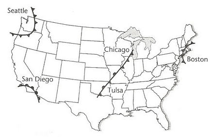
Which type of front is near Seattle?
a)
cold front
b)
warm front
c)
occluded front
d)
stationary front
42.
Which front is located near San Diego?
a)
cold front
b)
warm front
c)
occluded front
d)
stationary front
43.
Which type of front is located near Chicago?
a)
warm front
b)
cold front
c)
occluded front
d)
stationary front
44.
Which type of front is located near Boston?
a)
warm front
b)
cold front
c)
stationary front
d)
occluded front
45.
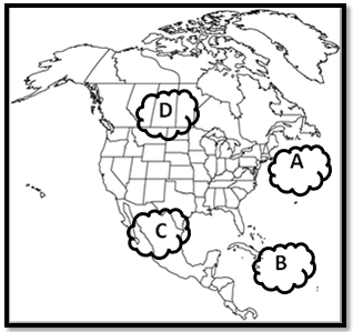
Which type of air would you find at air mass A?
a)
cold, dry
b)
warm, humid
c)
warm, dry
d)
cold, humid
46.
Which type of weather is associated with a cold front?
a)
heavy rain, snow, thunderstorms, and snow for short periods of time 
b)
Steady, light rain or snow can occur for longer periods of time 
47.
Which pressure system can produce storms?
a)
low pressure system
b)
high pressure system
48.
Which type of pressure system produces clear/fair/sunny weather?
a)
low pressure system
b)
high pressure system
49.
Where would you find a tropical maritime air mass?
a)
over the ocean, near the equator
b)
over the ocean, near the poles
c)
over a continent, near the equator
d)
over a continent, near the poles
50.
________ air is less dense and tends to  rise
a)
cold
b)
warm
c)
moist
d)
dry
51.
When warm and cold air meet, which one sinks to the bottom?
a)
warm
b)
cold
c)
both
d)
neither
52.
What causes a Tornado?
a)
Tectonic plates colliding together.
b)
When there is too much precipitation in a cloud.
c)
Warm moist air meeting cool dry air causing a instability in the atmosphere.
53.
What is a Tornado?
a)
A thunderstorm cloud that drops ice balls.
b)
When two tectonic plates hit and the earth starts to shake.
c)
When lava starts to erupt from a cone.
d)
A fierce rotating column of air extending to the ground.
54.

Tornadoes form when warm, moist air from the Gulf of Mexico and cool, dry air from Canada meet

a)

True

b)

False

55.
Critical for the formation of a hurricane?
a)
lower latitudes
b)
80 degrees or warmer water
c)
None of the above
d)
All of the above
56.
A hurricane gets its energy from
a)
Warm ocean waters
b)
high air pressure
c)
winds along surface
d)
Sun
57.
Coriolis Effect is a force caused by
a)
Earth's seasons
b)
Earth's spinning core
c)
Earth's tides
d)
Earth's rotation
58.
NOT a location where hurricanes form
a)
Northern Atlantic Ocean
b)
Indian Ocean
c)
Pacific Ocean
d)
Gulf of Mexico
59.
What could the energy from a hurricane do?
a)
Power the US for 1 day
b)
Power the US for 3 days
c)
Power the US for 3 weeks
d)
Power the US for 1/2 a year
60.
When do hurricanes usually develop?
a)
January through April
b)
September through October
c)
June through November
d)
January through June
61.
Where do the hurricanes that hit the US form?
a)
in warm water of the western Pacific ocean off the coast of South America
b)
in the warm water of a La Nina
c)
in the warm Atlantic water off the western coast of Africa
d)
in the warm Atlantic water off the coast of Hawaii
62.
Why does warm air rise?
a)
Warm air is more dense than cooler air.
b)
Warm air has more pressure than cooler air.
c)
Warm air is less dense than cooler air.
d)
Warm air has a higher dew point than cooler air.
63.
Which of the following is not a global wind belt?
a)
trade winds
b)
polar easterlies
c)
prevailing westerlies
d)
equator
64.
In which direction do prevailing westerlies flow?
a)
from east to west
b)
from west to east
c)
from north to south
d)
from south to north
65.
What two factors are needed to measure wind?
a)
direction and speed
b)
temperature and speed
c)
direction and temperature
d)
speed only
66.
Which describes how wind speed if affected by weather?
a)
rainy weather causes greater wind speeds
b)
warmer weather causes greater wind speeds
c)
differences in air pressure cause greater wind speeds
d)
small temperature changes cause greater wind speeds
67.
Which types of winds cause weather in North Carolina?
a)
polar easterlies
b)
prevailing westerlies
c)
polar westerlies
d)
prevailing easterlies
68.
What causes wind?
a)
convection currents
b)
conduction currents
c)
radiation currents
d)
tropical currents
69.
What direction is the cold front moving?
a)
Northwest
b)
Southeast
c)
Northeast
d)
Southwest
70.
What direction is the warm front moving?
a)
Northeast
b)
Northwest
c)
Southeast
d)
Southwest
71.

Why do you see precipitation near the L?

a)

because that is low pressure and that is where air rises, forming clouds

b)

because that is where air is falling and it brings rain with it

c)

because southern Ohio is always rainy this time of year

d)

because the cold front is meeting the warm front which forces warm air to rise rapidly forming clouds

72.

You would expect to see clouds forming and possible precipitation

a)

in Utah (the H)

b)

in Florida

c)

in Nebraska (between the H and the L)

d)

in Indiana

73.

When a cold front moves in

a)

it forces warm air to rise rapidly creating big clouds and likely rain

b)

it pushes against warm air and becomes a stationary front

c)

the cold air goes above the warm air causing a clear sky

d)

it forms a wedge and the warm air slowly rises and may form small clouds

74.
Warm air mass that does not carry water:
a)
continental tropical
b)
continental polar
c)
maritime tropical
d)
maritime polar