Wayground logo

Free Printable Worksheets

Font size

S
M
L
XL
Worksheets

Unit 4 - Investigating Global Weather Patterns

Total questions: 56

Worksheet time: 2hrs 57mins

Name
Class
Date
1.
Rain, snow, sleet, and hail are all forms of _____.
a)
precipitation
b)
condensation
c)
evaporation
d)
climate
2.
A violently rotating column of air called a _____ when it comes in contact with the ground.
a)
hurrican
b)
tornado
c)
trade wind
d)
local wind
3.
When two air masses meet, there is a _____, or boundary.
a)
thunderstorm
b)
watch
c)
front
d)
cloud
4.
A _____ is a large, swirling, low-pressure system that forms over the Atlantic Ocean.
a)
blizzard
b)
cold front
c)
tornado 
d)
hurricane
5.
what kind of pressure predicts good weather?
a)
high
b)
low
c)
cold
d)
stationary
6.
name this front
a)
warm front
b)
cold front
c)
stationary front
d)
occluded front
7.
name this front
a)
warm front
b)
cold front
c)
stationary front
d)
occluded front
8.
Which condition usually means cloudy, stormy weather?
a)
high pressure
b)
low pressure
9.
What part of the illustration shows Evaporation? 
a)
1
b)
2
c)
3
d)
4
10.
Which number illustrates Condensation?
a)
1
b)
2
c)
3
d)
4
11.
What kind of weather is usually associated with a high pressure system?
a)
Sunny weather
b)
Precipitation (rain, snow, etc.)
12.
What role do oceans play in hurricane formation?
a)
they provide cool, dense water
b)
warm water supplies energy to hurricanes
c)
warm ocean water slows hurricane formation
d)
cold ocean water supplies energy to hurricanes
13.
Which term describes a circulation of air or water that is caused by uneven heating?
a)
convection current
b)
conduction current
c)
radiation current
d)
emission current
14.
Every few years, an event occurs in which the waters in the eastern Pacific Ocean become warmer. This event changes weather patterns worldwide, causing drought, floods, blizzards, hurricanes and tornadoes. What is the name of this event?
a)
Kuroshio Current
b)
Global conveyor
c)
El Nino
d)
Typhoon
15.
The ozone is in the stratosphere layer of the atmosphere. The purpose of the ozone is
a)
To generate heat for the earth
b)
To protect earth from the harmful solar radiation
c)
To produce weather
d)
To allow satellites to circle the earth
16.
 Which of the following are used to study and forecast most weather-related events?
a)
Doppler radar
b)
satellites and satellite images
c)
weather maps
d)
all of the above
17.
Which statement best describes the difference between weather and climate?
a)
Weather is the conditions when you look outside while climate is the conditions you can expect for the next 6 months.
b)
Climate is the current condition outside while weather is what you can expect for the next 6 months.
18.
Which of the following will heat the fastest? 
a)
water
b)
land
c)
both heat at equal rates
19.
____________ air sinks/falls because it is ____________dense.
a)
Cold, More
b)
Warm, Less
c)
Cold, Less
d)
Warm, More
20.
____________ air rises because it is ____________dense.
a)
Cool, Less
b)
Warm, Less
c)
Cold, More
d)
Warm, More
21.
An instrument used to measure how hot or cold something is
a)
barometer
b)
thermometer
c)
wind sock
d)
rain guage
22.
the amount of water vapor in the air
a)
warm front
b)
precipitation
c)
humidity
d)
air pressure
23.
An instrument that measures air pressure
a)
thermometer
b)
barometer
c)
rain guage
d)
wind sock
24.
The amount of mass in a given volume of air is _.
a)
density
b)
pressure
c)
altitude
d)
air pressure
25.
The layer of the atmosphere where weather occurs is the _.
a)
thermosphere
b)
stratosphere
c)
mesosphere
d)
troposphere
26.
An anemometer is used to measure...
a)
air pressure
b)
humidity
c)
precipitation
d)
wind speed
27.
Do hurricanes have powerful circular winds ?
a)
True
b)
False
28.
Is it a possibility that Hurricanes usually form over really ocean warm water at around 80 o F or warmer ?
a)
True 
b)
False
29.
The phenomenon called the _______ is needed to create the spin in the hurricane and it becomes.
a)
Circular Wind Force
b)
Upshot Effect
c)
Hurricane Force
d)
Coriolis Force
30.
How fast are Hurricanes generally ?
a)
As fast as Usain Bolt
b)
75 - 200mph 
c)
100 - 210mph
d)
Less than 75
31.
From the image which country are affected by Hurricanes in the Caribbean
a)
Jamaica, Haiti, Dominican Republic
b)
Japan, United States, Australia 
c)
New Zealand, China, China
32.
Hurricanes are formed generally in the ?
a)
Northern hemisphere and clockwise direction in the Western Hemisphere. 
b)
Northern hemisphere and clockwise direction in the Southern Hemisphere. 
c)
Western hemisphere and anti-clockwise direction in the Eastern Hemisphere.
33.
What happens when a hurricane crosses over land?
a)
 it moves more quickly 
b)
it breaks apart and forms tornadoes
c)
it loses strength
d)
It speeds up
34.
In what areas of the world do hurricanes form?
a)
Warm ocean waters
b)
Polar ocean waters
c)
On lakes and rivers
d)
Over the central plains of the U.S
35.
What types of air masses form over oceans?
a)
Maritime
b)
Continental
c)
Polar
d)
Tropical
36.
Where do typhoons form?
a)
In a river or stream
b)
Over the ocean
c)
At plate boundaries
d)
Under the Earth
37.
Where do typhoons often make their way?
a)
South America
b)
Middle East
c)
South East Asia
d)
Europe
38.
Which of the following is not an "ingredient" in typhoon formation?
a)
warm ocean waters
b)
coriolis force
c)
high humidity
d)
cold and warm air
39.
What locations in the United States are most vulnerable to hurricanes?
a)
Florida
b)
Washington
c)
Tennessee
d)
Arkansas
40.
What is the “fuel” that “feeds” a hurricane
a)
cold air
b)
dry air
c)
warm and moist air
d)
warm and dry air
41.
What is the source for warming up ocean water?
a)
the sun
b)
water movement
c)
wind
d)
fish peeing in the ocean water
42.
The cycle that powers the ocean currents, weather, and tectonic plates it called
a)
conduction current
b)
radiation
c)
condition current
d)
convection current
43.
Warm air rises and the cool air sinks demonstrates this type of heat transfer. 
a)
conduction
b)
convection
c)
radiation
d)
Insolation 
44.

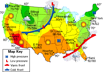
The weather map shows the weather conditions for one day across the United States. Based on the weather map, which city will most likely experience decreasing temperatures during the next 24 hours?

a)

Denver, because its raining there

b)

Minneapolis, because a cold front is approaching

c)

Atlanta, because a warm front is approaching

d)

Houston, because it is in a high pressure area

45.

In 2011, Typhoon Nesat struck the Phillippines and caused widespread flooding. After hitting the Phillippines, Typhoon Nesat was predicted to hit the large city of Hanoi, Vietnam. If Typhoon Nesat had continued along the same path, which development would most likely have reduced its strength before it hit Hanoi.

a)

The formation of a low pressure area south of Bangkok

b)

The formation of a high pressure area south of Bangkok

c)

Cool water moving into the sea east of Hanoi

d)

Warm water moving into the sea east of Hanoi

46.

Thunderstorms are more common in some areas than others. The map shows the average number of thunderstorms per year in different parts of the United States. Why are the significantly more thunderstorms in Florida than in California?

a)

The state of Florida is smaller than the state of California.

b)

The air in Florida is more stable than the air in California.

c)

The air above Florida holds less moisture than the air above California.

d)

The ocean currents near Florida are warmer than the ocean currents in California.

47.

Hurricanes and similar storm systems begin over oceans. The map below shows average surface temperatures of the oceans in the summer. Based on the map, which area probably produced the most violent storm systems?

a)

Area 1

b)

Area 2

c)

Area 3

d)

Area 4

48.
Which of these best explains why the oceans have a great impact on the weather over the continents?
A) Ocean waves move more easily than continental rock.
B) The oceans contain a wider variety of organisms than the continents.
C) The oceans store and transfer more heat than the continents.
D) Ocean water contains more salt than most continental lake water.
a)
A
b)
B
c)
C
d)
D
49.
Why do hurricanes in the northern hemisphere move from Africa towards North America? 
A.The Coriolis Effect and the trade winds steer most weather patterns from right to left in the northern hemisphere.
B.Trade winds have a tendency to influence weather patterns to move from left to right across the northern hemisphere increasing the chances of hurricanes to form.
C.The strength of the Coriolis Effect is much weaker in higher latitudes and the trade winds drive weather patterns to move in a north-easterly pattern.
D.Strong ocean waves push weather patterns in a north-westerly motion across the Atlantic and produces hurricanes as they move.
a)
A
b)
B
c)
C
d)
D
50.
A low pressure system is located over Georgia. What type of weather will they have?
a)
clear, sunny skies
b)
cloudy and rainy
51.
A cold front is approaching Minneapolis. What will happen to the air temperature?
a)
stay the same
b)
increase
c)
decrease
52.
The picture represents the symbol for a _______________________Front.
a)
Cold
b)
Warm
c)
Occluded
d)
Stationary
53.
Where do most hurricanes develop?
a)
Middle of the United States
b)
Near the Equator
c)
Near Canada and Alaska
d)
Antarctica
54.
What is the difference between a hurricane, a typhoon, and a tropical cyclone?
a)
Begin on different dates
b)
Begin in warm waters
c)
Begin in different locations
d)
Begin/end on time
55.
Coriolis Effect is a force caused by
a)
Earth's seasons
b)
Earth's spinning core
c)
Earth's tides
d)
Earth's rotation
56.
At night,  the denser cool air over the land moves in and replaces the less dense, warmer air that rises over the ocean.  This is called 
a)
sea breeze
b)
land breeze
c)
trade winds