
 Worksheets
NCFE Review #3 Hydrology
Total questions: 62
Worksheet time: 35mins
Name
Class
Date
1.
Ocean currents are powered by
a)
Conduction
b)
Convection
c)
Radiation
2.
Groundwater is found underground in the zone of
a)
aeration
b)
saturation
c)
porosity
d)
permeability
3.
Groundwater flow is affected by the _ of soil.
a)
porosity
b)
type
c)
location
d)
aeration
4.
Which of the following is not a major source of groundwater pollution?
a)
sewage
b)
pesticides
c)
industrial chemicals
d)
compost
5.
The term for water evaporating from plants is
a)
transpiration
b)
precipitation
c)
runoff
d)
infiltration
6.
An ocean current flowing from the south pole to the equator is most likely a
a)
warm current
b)
cold current
7.
An ocean current flowing from the equator to the north pole is most likely a
a)
warm current
b)
cold current
8.
The majority of earth's fresh water is found where?
a)
in the ground
b)
in lakes and rivers
c)
in glaciers/ice
d)
on top of mountains
9.
The water cycle is powered by the
a)
sun
b)
moon
c)
plate tectonics
d)
precipiation
10.
What is not a role of wetlands?
a)
recharge water with nutrients
b)
drain bordering land
c)
provide habitat for organisms
d)
create power
11.
In the ocean, how are surface currents powered?
a)
gravity
b)
density
c)
wind
d)
spinning of Earth
12.
The Global Conveyor Belt (deep water currents) are powered by which of the following?
a)
wind
b)
density
c)
heating
d)
precipitation
13.
Warm ocean currents generally come from
a)
The North Pole
b)
The South Pole
c)
The Equator
d)
Both A and B
14.
Cold ocean currents generally come from
a)
The North Pole
b)
The South Pole
c)
The Equator
d)
Either Pole
15.
A horizontal movement of ocean water that is caused by wind and that occurs at or near the ocean's surface.
a)
Gulf Stream
b)
Global Conveyor Belt
c)
Surface Current
d)
Gyre
16.
Deep Ocean currents are a result of
a)
Global Wind Patterns
b)
Earth's Rotation
c)
Density
d)
All of the above
17.
The Gulf stream carries _____________ water from the east coast of The United States to the West coast of Europe.
a)
Cold
b)
Warm
c)
Freezing
d)
Fresh
18.
The California Current (west coast) carries _________ water from canada
a)
Cold
b)
Warm
c)
Freezing
d)
Fresh
19.
Two types of water currents are
a)
local and global
b)
sea and land
c)
surface and deep
d)
warm and cold
20.
Where is ocean water the densest.
a)
The surface
b)
The middle
c)
The bottom
d)
Lake Michigan
21.
When surface currents meet continents they ___?
a)
Stop moving
b)
Are deflected (change paths)
c)
Continue in the direction they were going
22.

Wha type of tide would this arrangement of earth-moon-sun create?
a)
full moon tide
b)
new moon tide
c)
neap tide
d)
spring tide
23.

What type of tides would this arrangement of earth-moon-sun create?
a)
neap tide
b)
spring tide
c)
new moon tide
d)
full moon tide
24.
Which of the following can be caused by El Nino~?
a)
Flash floods
b)
Mudslides
c)
Droughts
d)
All of the above
25.
Upwelling is associated with
a)
a decrease in access to nutrients for phytoplankton
b)
cooler, nutrient-rich waters being pushed up from deeper ocean waters
c)
temperature gradients moving water from the equator to the poles
d)
an increase in human fatalities
26.
The Coriolis effect is...
a)
The curvature of things as they move across the Earth's surface.
b)
The reflection of the Sun's light on the moon.
c)
The heating of the earth by greenhouse gasses.
d)
What determines the speed at which the Earth spins.
27.
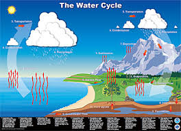
Which stage does ground water try to return to the ocean or soak into the ground?
a)
condensation
b)
evaporation
c)
precipitation
d)
run off
28.
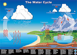
Which stages does liquid water from the ocean turn into water vapor?
a)
condesantion
b)
evaporation
c)
precipitation
d)
run off
29.
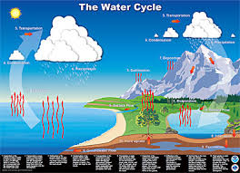
During which stage do clouds form?
a)
condensation
b)
evaporation
c)
precipitation
30.
On which kind of day would you expect the most evaporation from the surface of a pond?
a)
warm, sunny
b)
cold, sunny
c)
warm, rainy
d)
cold, rainy
31.
Which represents the distribution of water on Earth?
a)
3% freshwater, 97% salt water
b)
97% freshwater, 3% salt water
c)
71% freshwater, 29% salt water
d)
29% freshwater, 71% salt water
32.
What is porosity?
a)
how the holes change in rocks without water
b)
how much time it takes water to run through rocks
c)
how much water can be held in rocks and other earth's substances
33.
What causes deep ocean currents?
a)
moon's gravitational pull
b)
temperature, density, salinity
c)
wind
34.
Why is most of Earths freshwater is not available for human use.
a)
because it's in the ground
b)
because it's frozen in ice caps and glaciers
c)
because of pollution
d)
because of global warmin
35.
Which is the primary cause of surface winds on Earth?
a)
Unequal heating of the Earth
b)
Deflection in prevailing winds caused by the coriolis effect.
c)
Rotational speeds of Earth's surface at various latitudes.
36.
Which best describes the water in an estuary?
a)
fresh
b)
brackish
37.
NC climate is moderated by which local current?
a)
East Australain
b)
Gulf Stream
c)
Antarctic Bottom Water
d)
South Equatorial
38.
Allows water to flow through
a)
Permeable
b)
Porous
c)
Impermeable
d)
Non-porous
39.
Temperature and salinity variations in ocean water cause:
a)
Mid-ocean ridges
b)
Horizontal and vertical ocean currents
c)
Refraction of ocean waves
d)
Ebb and flow of the tides
40.
Upwelling is when deep ocean waters rise to the surface. Upwelling will occur if:
a)
The deep water is saltier than the shallower water
b)
The deep water is denser than the shallower water
c)
Wind blows the shallow water along the coast away from the coast
d)
Wind blows the shallow water along the coast towards the coast.
41.
The climate in cities that are close to a large body of water tends to be:
a)
Cooler in the summer and warmer in the winter than inland cities
b)
Cooler in the winter and warmer in the summer than inland cities
c)
Cooler in the winter and the summer than inland cities
d)
Warmer in the winter and the summer than inland cities
42.
The large, circular surface-current pattern found in each ocean.
a)
California Current
b)
Surface Current
c)
Gyre
d)
Global Conveyor Belt
43.

Suppose there is a drought in this area. The level of the river drops because of it.
What else could happen here?
What else could happen here?
a)
The river will immediately rise again.
b)
The water table will rise.
c)
The water table will fall.
d)
A new aquifer will form.
44.
What is the source of most surface water and groundwater?
a)
Snow
b)
Precipitation
c)
Run-off
d)
Wastewater
45.

Able to allow water to pass through
a)
Permeability
b)
Runoff
c)
Pores
d)
Permeable
46.

Open spaces between soil particles that allow water to pass through
a)
Aquifer
b)
Well
c)
Pores
d)
Spores
47.
What is a place where groundwater seeps out of the ground called?
a)
Well
b)
Reservoir
c)
Aquifer
d)
Spring
48.
What are sources of water pollution?
a)
Precipitation as Acid rain
b)
Runoff water & Groundwater
c)
Industry & Household waste
d)
All of these
49.
What do we call the land area that supplies water to a river system?
a)
runoff
b)
recharge
c)
watershed
d)
valley
50.
What do we call water that flows over the ground surface rather than soaking in?
a)
runoff
b)
discharge
c)
recharge
d)
tributary
51.

The mountain ridge shown in this picture would be this part of a watershed (drainage basin).
a)
aquifer
b)
divide
c)
water table
d)
zone of aeration
52.

The land around these rivers is known as the ________________.
a)
tributary
b)
divide
c)
water system
d)
watershed
53.

Which of the following statements is true about the development of a stream?
a)
a stream's slope increases as it approaches base level
b)
water along the sides and bottom of the channel flows more rapidly
c)
deposition is greater in the outside curve of a meander
d)
the velocity of water is greater along the outside of a meander curve
54.

A blocked-off meander eventually becomes ___________.
a)
part of the stream again
b)
rejuvenated
c)
an oxbow lake
d)
an alluvial fan
55.

The stream that flows into a larger stream.
a)
gully
b)
tributary
c)
stream
d)
rill
56.

A wide, sloping deposit of sediment formed where a stream leaves a mountain range.
a)
flood plain
b)
delta
c)
alluvial fan
d)
gully
57.

A landform made of sediment that is deposited where a river flows into an ocean or lake.
a)
delta
b)
alluvial fan
c)
flood plain
d)
oxbow lake
58.
Ocean circulation transports ______________ from the Equator to the North Pole and South Pole.
a)
salt
b)
heat
c)
carbon dioxide
d)
nutrients
59.
During __________ the Southeast Trade Winds weaken.
a)
Normal Conditions
b)
El Nino
60.
During __________ the Pacific warm pool migrates eastward.
a)
Normal Conditions
b)
El Nino
61.
During __________ upwelling occurs off the coast of Peru.
a)
Normal Conditions
b)
El Nino
62.
During __________ downwelling decreases biological activity.
a)
Normal Conditions
b)
El Nino
100 %

