Wayground logo

Free Printable Worksheets

Font size

S
M
L
XL
Worksheets

Oceans TEST review 2019

Total questions: 70

Worksheet time: 54mins

Name
Class
Date
1.
What causes surface currents?
a)
wind
b)
salinity
c)
temperature
d)
density
2.
What causes deep currents?
a)
differences in density
b)
wind
c)
weather
d)
Coriolis effect
3.
Which process will increase the salinity of ocean water?
a)
evaporation
b)
currents
c)
Coriolis effect
d)
density
4.
How will the melting of icecaps change the salinity of ocean water?
a)
raise the salinity
b)
lower the salinity
c)
no change to the salinity
d)
I have no idea
5.
As the ocean depth increases, how to temperature and density change?
a)
it gets colder and more dense
b)
it gets colder and less dense
c)
it gets warmer and more dense
d)
it gets warmer and less dense
6.
What is a deep valley in the ocean formed at a convergent boundary?
a)
continental shelf
b)
mid-ocean ridge
c)
trench
d)
abyssal plain
7.
What is a long, underwater mountain chain formed at a divergent plate boundary?
a)
trench
b)
mid-ocean ridge
c)
continental shelf
d)
continental rise
8.
What is the measure of the amount of dissolved salts in a liquid?
a)
density
b)
salinity
c)
density
d)
Coriolis effect
9.
What is the primary cause of waves?
a)
wind
b)
density
c)
salinity
d)
the moon
10.
We have _____ tides each day.
a)
1 high and 1 low
b)
2 high and 2 low
c)
4 high
d)
it depends
11.
as salinity increase density
a)
increases
b)
decreases
c)
stays the same
12.
Thermohaline currents are also called ________________ currents.
a)
Deep Water
b)
Coriolis
c)
Saltwater
13.
Salt in the oceans comes from ___
a)
near shore salt deposits
b)
water moving through rocks and soil
c)
mid ocean ridges
d)
under water volcanoes
14.
What is the temperature of water moving away from the poles
a)
it is warm
b)
it is cold
15.
The average amount of salt in an ocean is about:
a)
3.5%
b)
70%
c)
97%
16.

During which moon phases will Earth experience the strongest, or greatest difference between high and low tides?

a)

First Quarter and Full Moon

b)

First Quarter and Last Quarter

c)

New Moon and Full Moon

d)

New Moon and Last Quarter

17.

During which moon phases will Earth experience the weakest, or least difference between high and low tides?

a)

First Quarter and Full Moon

b)

First Quarter and Last Quarter

c)

New Moon and Full Moon

d)

New Moon and Last Quarter

18.

The movement of water to the right that is caused by Earth's rotation.

a)

gyre

b)

upwelling

c)

ocean current

d)

Coriolis Effect

19.
Due to the Coriolis Effect, water in the northern hemisphere moves
a)
clockwise
b)
counter clockwise
c)
both
d)
neither
20.
Due to the Coriolis Effect, water in the southern hemisphere moves
a)
clockwise
b)
counter-clockwise
c)
both
d)
neither
21.
Two types of water currents are
a)
local and global
b)
sea and land
c)
surface and deep
d)
warm and cold
22.
When surface currents meet continents they ___?
a)
Stop moving
b)
Are deflected (change paths)
c)
Continue in the direction they were going
23.
Which causes the subtropical jet stream to bring cold, wet winter weather to the southeastern United States?
a)
El Niño
b)
La Nina
c)
Coriolis effect
d)
Santa Anna Winds
24.
Which weather conditions are associated with El Niño?
a)
increased temperature, increased precipitation
b)
decreased temperature, increased precipitation
c)
increased temperature, decreased precipitation
d)
decreased temperature, decreased precipitation
25.
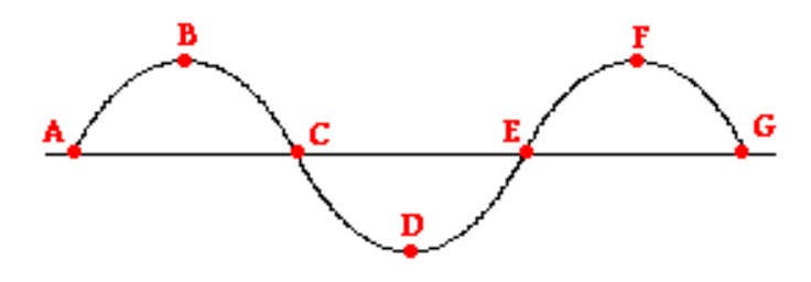
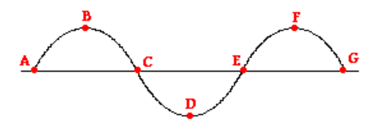
Which letter(s) represent the trough of the wave?
a)
A
b)
B & D
c)
D
d)
C & G
26.
Which letter(s) represent the crest of the wave?
a)
A
b)
B & D
c)
B & F
d)
F
27.
Which vocabulary term is used to identify the distance between points C & G?
a)
Amplitude
b)
Crest
c)
Frequency
d)
Wavelength
28.
The number of wavelengths that pass a point each per second is:
a)
frequency
b)
period
c)
longitudinal 
d)
transverse wave 
29.

What is the deepest part of the oceans?

a)

Mid-ocean ridge

b)

Abyssal plain

c)

Trench

30.
What is a gently sloping, shallow area of the ocean floor that extends outward from the edge of the continent?
a)
continental shelf
b)
continental rise
c)
continental slope
d)
seamount
31.
What do you call a steep incline of the ocean floor leading down from the edge of the continental shelf?
a)
continental slope
b)
trench
c)
deep ocean basin
d)
continental rise
32.
What do you call a mountain rising from the ocean seafloor that does not reach to the water's surface (sea level) and thus is not an island?
a)
trench
b)

abyssal plain

c)
seamount
d)
seamount island
33.
Which best represents the order of seafloor features as you move from the shoreline to the deep ocean?
a)
 Continental slope – continental shelf- continental rise – mid-ocean ridge
b)
 Continental rise – continental shelf – mid-ocean ridge -  continental slope
c)
 Continental shelf – continental slope – continental rise – mid-ocean ridge
d)
   Mid-ocean ridge – continental rise – continental shelf- continental slope
34.

Which is the largest ocean?

a)

Pacific

b)

Atlantic

c)

Antarctic

d)

Indian

35.

What is letter I?

a)

Cont. Shelf

b)

Mid-Ocean Ridge

c)

Volcanic Island

d)

Seamount

36.

What is letter F?

a)

Mid-Ocean Ridge

b)

Seamount

c)

Trench

d)

Continental Shelf

37.

What is letter H?

a)

Abyssal plain

b)

Seamount

c)

Continental slope

d)

Continental rise

38.

What is letter C?

a)

Continental slope

b)

Seamount

c)

Mid-ocean ridge

d)

Submarine canyon

39.
At the end of the continental slope, the ocean floor gradually flattens into the __________________.
a)
abyssal plain
b)
trench
c)
continental slope
d)
continental shelf
40.
Seamount is similiar to...
a)
a volcanic island
b)
a small mountain or volcano
c)
The Great Plains
d)
The Grand Canyon
41.

A flat-topped seamount made flat by erosion is called a

a)

abyssal hill

b)

guyot

c)

ridge

d)

abyssal plain

42.
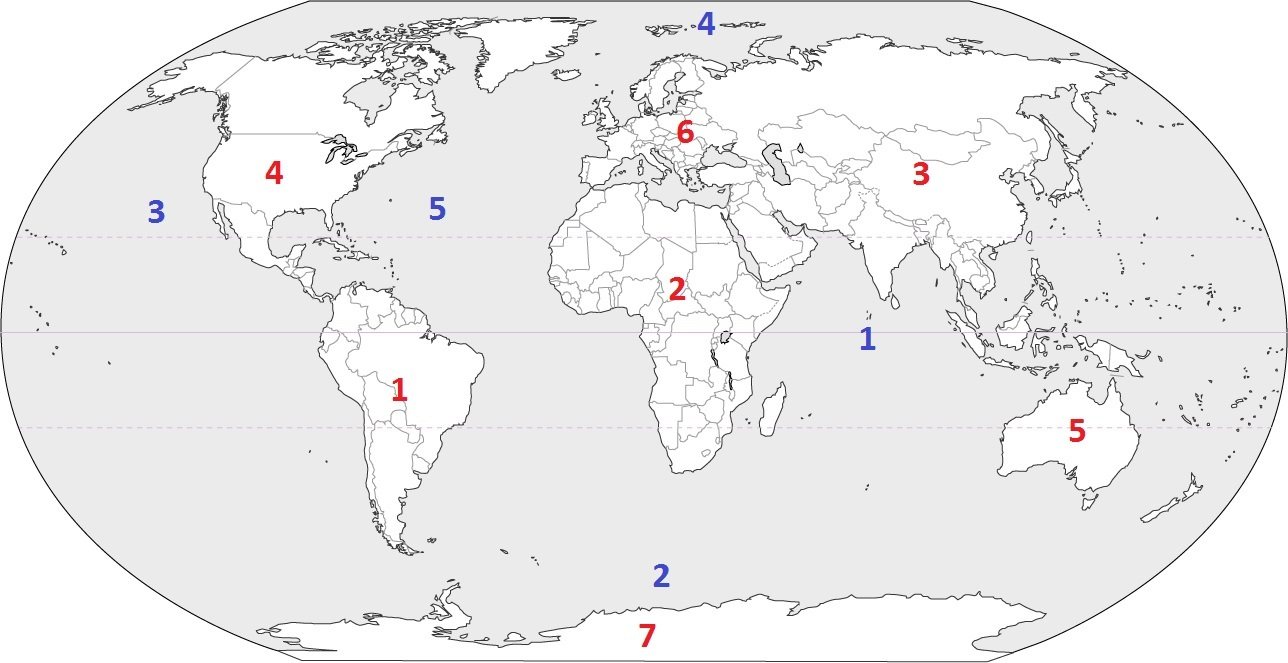
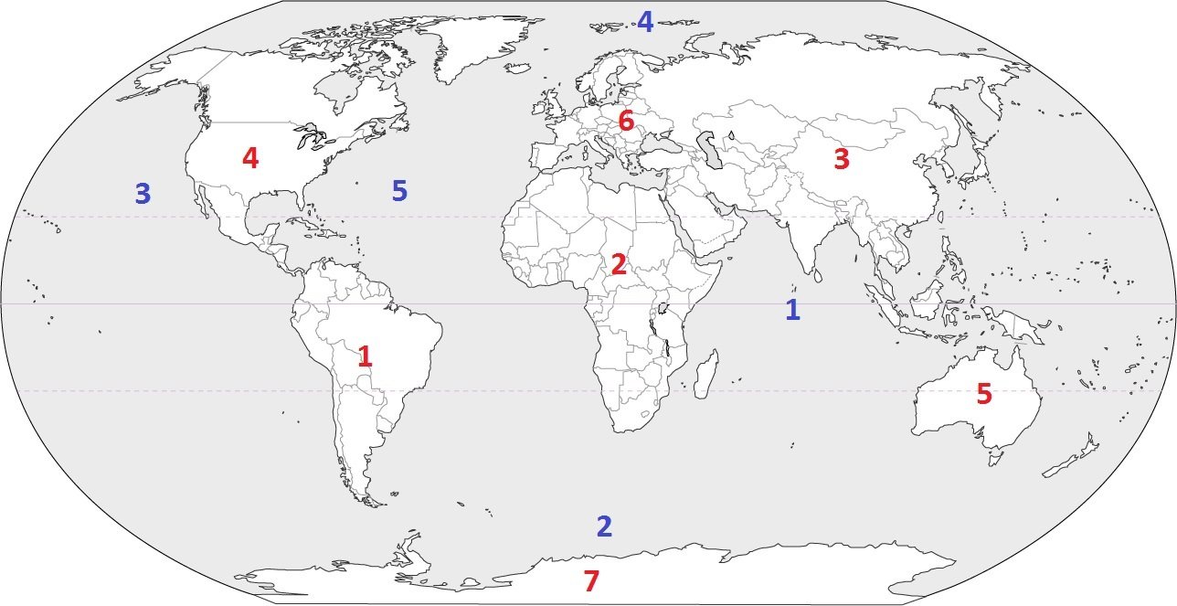
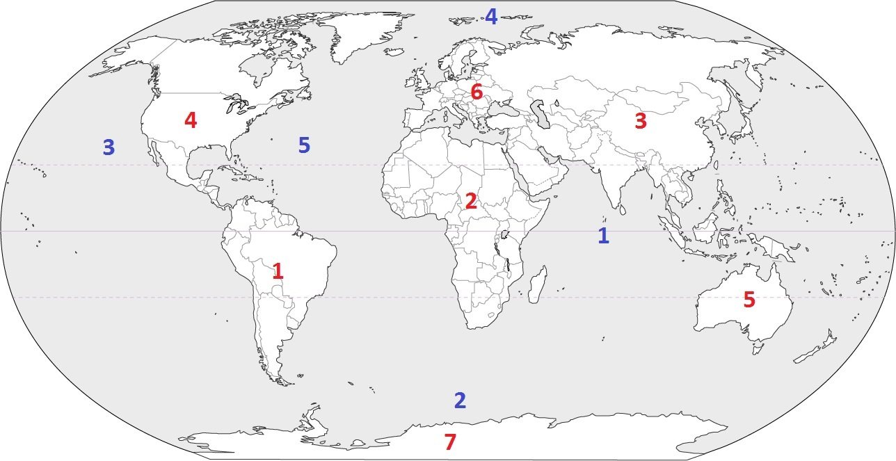
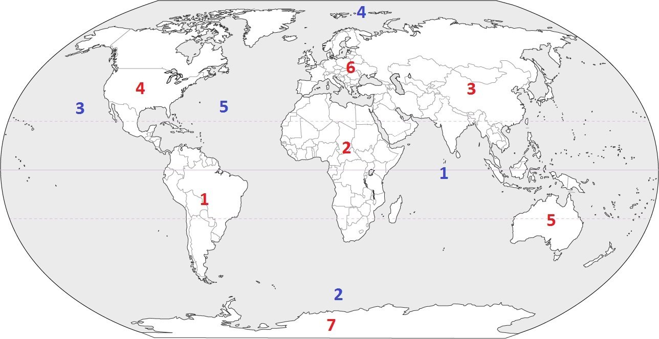
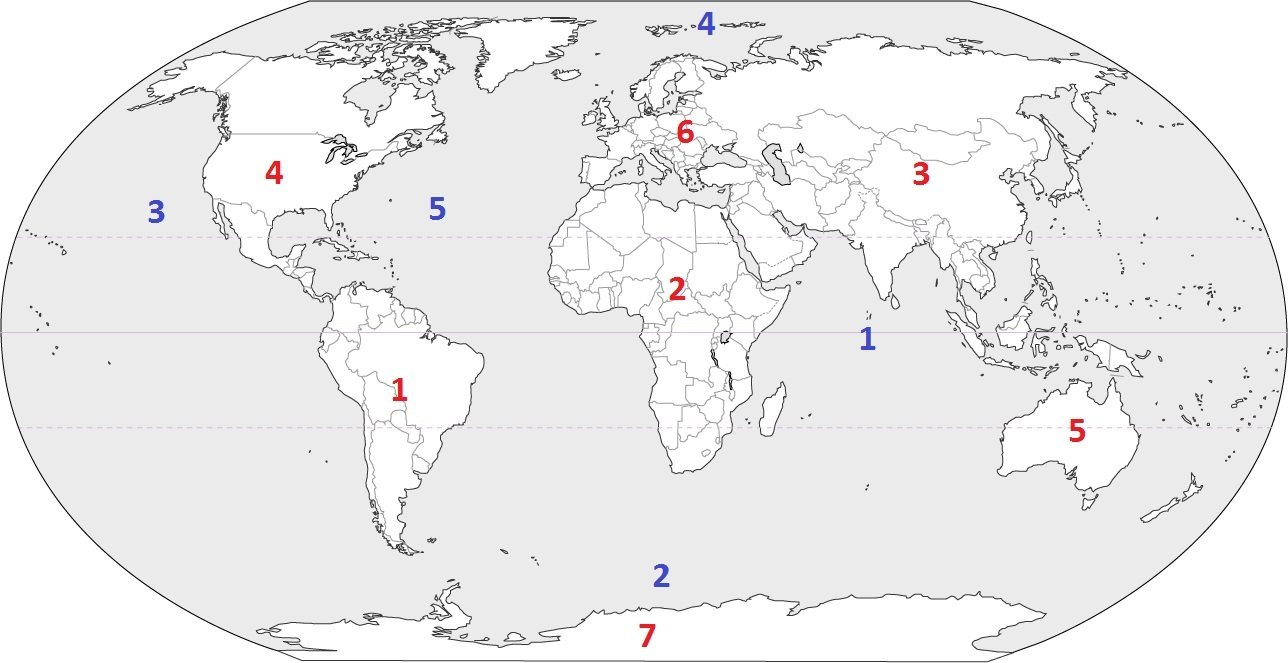
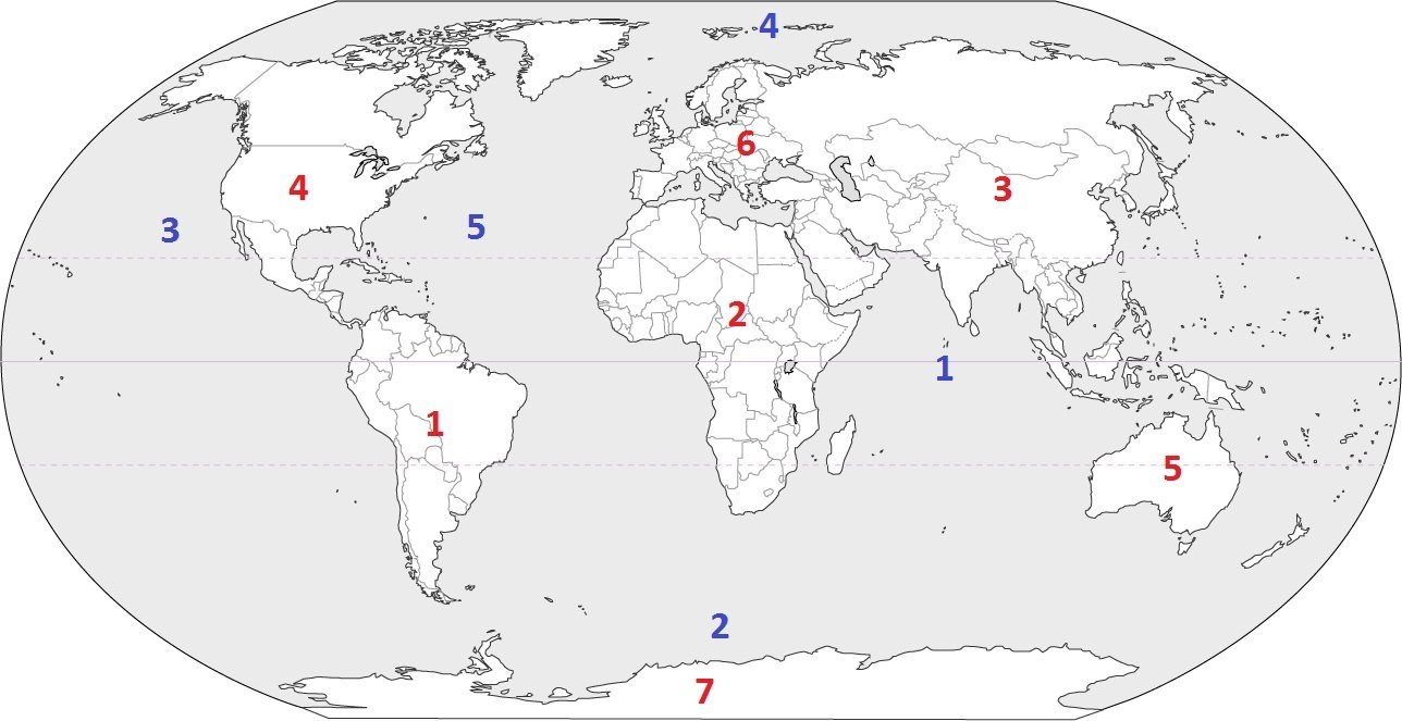
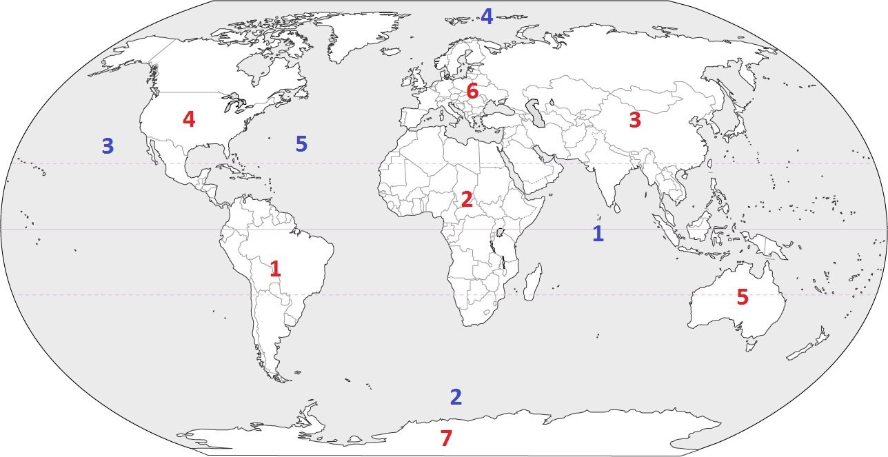
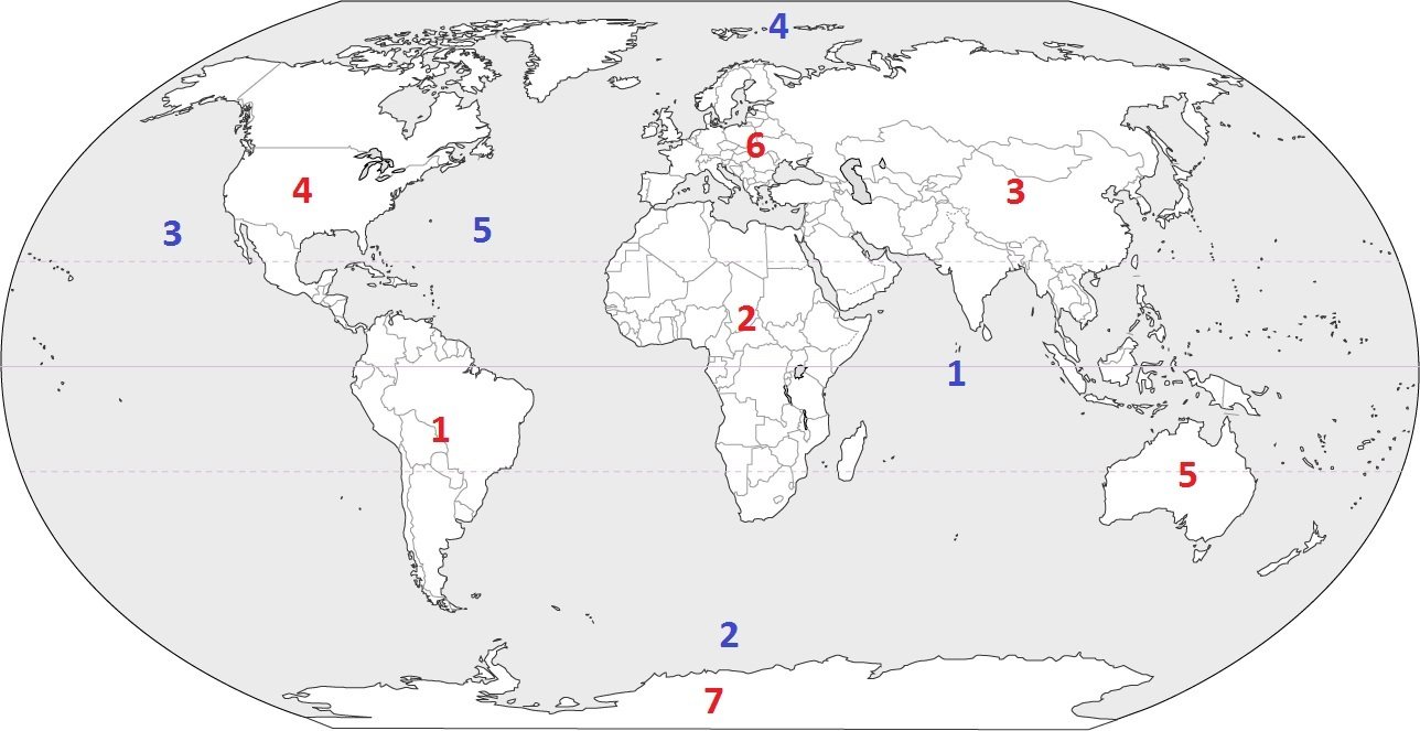
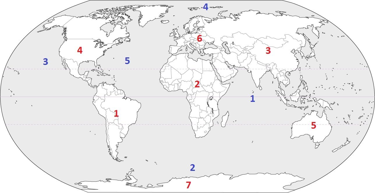
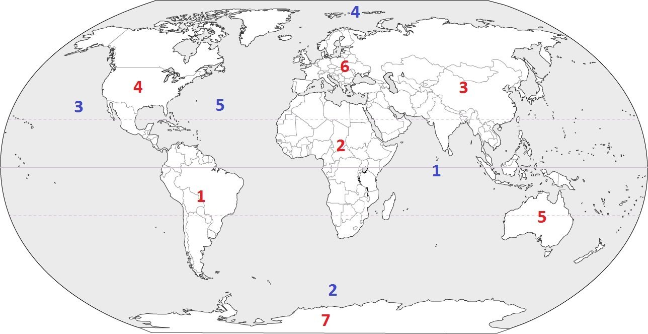
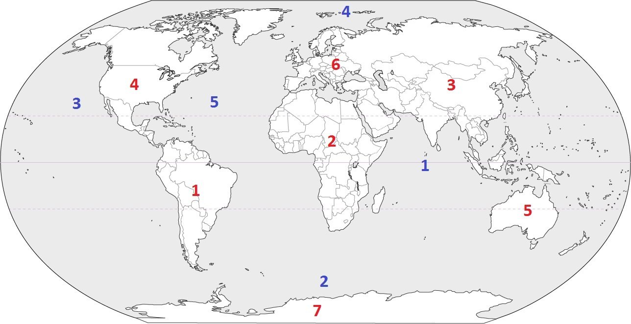
Which continent is located at #3?
a)
Australia
b)
Asia
c)
Europe
d)
South America
43.
Which continent is located at #5?
a)
South America
b)
Asia
c)
Australia
d)
Antarctica
44.
Which continent is located at #7?
a)
Asia
b)
Africa
c)
Australia
d)
Antarctica
45.
Which continent is located at #4?
a)
South America
b)
North America
c)
Europe
d)
Africa
46.
Which continent is located at #1?
a)
North America
b)
Antarctica
c)
South America
d)
Asia
47.
Which continent is located at #6?
a)
Asia
b)
Europe
c)
Africa
d)
Antarctica
48.
Which continent is located at #2?
a)
Africa
b)
South America
c)
Australia
d)
Europe
49.
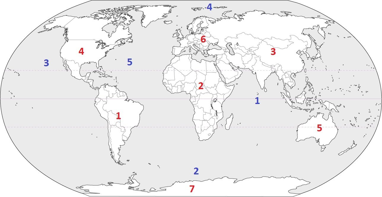
Identify the ocean at location #5
a)
Atlantic Ocean
b)
Southern Ocean
c)
Pacific Ocean
d)
Arctic Ocean
50.
Identify the ocean at location #3
a)
Atlantic Ocean
b)
Arctic Ocean
c)
Pacific Ocean
d)
Indian Ocean
51.
Identify the ocean at location #2
a)
Indian Ocean
b)
Pacific Ocean
c)
Southern Ocean
d)
Arctic Ocean
52.
Identify the ocean at location #1
a)
Southern Ocean
b)
Arctic Ocean
c)
Atlantic Ocean
d)
Indian Ocean
53.
Identify the ocean at location #4
a)
Indian Ocean
b)
Pacific Ocean
c)
Arctic Ocean
d)
Atlantic Ocean
54.
Identify the ocean at location #4
a)
Indian Ocean
b)
Pacific Ocean
c)
Arctic Ocean
d)
Atlantic Ocean
55.
Name Continent A!
a)
North America
b)
Africa
56.
Name Continent B!
a)
South America
b)
Europe
57.
Name Continent C!
a)
Antarctica
b)
Europe
58.
How many oceans are there in the world?
a)
7
b)
6
c)
5
d)
4
59.
How many continents are there in the world?
a)
4
b)
5
c)
6
d)
7
60.
The Gulf stream carries _____________ water from the east coast of The United States to the West coast of Europe.
a)
Cold
b)
Warm 
c)
Freezing
d)
Fresh
61.
Warm ocean currents generally come from
a)
The North Pole
b)
The South Pole
c)
The Equator
d)
Both A and B
62.
Deep Ocean currents are a result of
a)
Global Wind Patterns
b)
Earth's Rotation
c)
Density
d)
All of the above
63.
The Coriolis Effect is caused by
a)
Earth rotating around the sun
b)
Earth rotating on its axis
c)
The tides
d)
Gravity
64.
How do warm-water currents affect the coastal areas along which they flow?
a)
Cool the coast
b)
Warm the coast
c)
Cause snow to fall
d)
Cause higher tides
65.

What is the main energy source that drives ocean movement?

a)

Earth's core

b)

the sun

c)

radioactive rocks on the bottom of the ocean

d)

fossil fuels

66.

________ and _______ affect the ocean's density and cause the Global Conveyor Belt to travel

a)

gravity and the Coriolis Effect

b)

temperature and salinity

c)

wind and climate

d)

temperature and the Coriolis Effect

67.
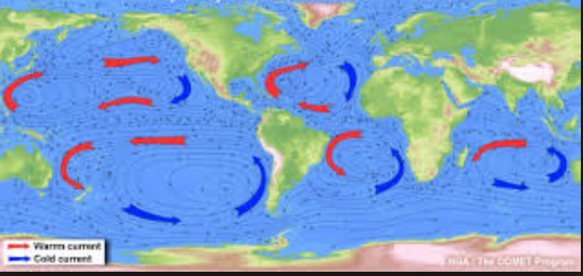
Analyze the image. The red arrows represent warm water rising and the blue arrows represent cold water sinking. What type of heat transfer is responsible for this movement?
a)
conduction
b)
convection
c)
radiation
68.
Analyze the map.
Why is it warmer in Charleston than it is in San Diego even though they are the same distance from the Equator?
a)
San Diego is affected by the Gulf Stream
b)
Charleston is affected by the California current
c)
Charleston is affected by the Gulf Stream
69.
Analyze the map.
Why is it colder in San Diego than it is in Charleston even though they are the same distance from the Equator?

a)
San Diego is affected by the Gulf Stream
b)
Charleston is affected by the California current
c)
San Diego is affected by the California Current
70.
 Which of the following  best describes the climate?
a)
The long-term average weather conditions that occur in a particular region.
b)
The short-term average weather condition in a country
c)
The long-term average conditions in a country