
 Worksheets
Mapping Our World Test Review
Total questions: 35
Worksheet time: 31mins
Equator
International Date Line
Prime Meridian
Tropic of Cancer
Lines of __________ converge at the poles.
Latitude
Longitude
Lines of ___________ are parallel.
Latitude
Longitude
What is the latitude of the North Pole?
150 degrees
180 degrees
90 degrees
100 degrees
Lines of ______ measure how far from the equator a place is located.
Longitude
Latitude





How many time zones are in the U.S. altogether?
4
8
6
7

What time zone would California be in?
Pacific Time
Mountain Time
Western Time
Eastern Time

If it is 5:00 pm in Miami, Florida, what time is it in Denver, Colorado?
3:00pm
8:00pm
4:00pm
6:00am

How many time zones are there in the world?
24
12
6
48
Why does distortion occur on every map?
Cartographers are politically biased.
GIS technology encourages errors.
The 3D world cannot be accurately converted to 2D
A map projection made by projecting points and lines from a globe onto a piece of paper.
Mercator
Gnomonic
Conic
Topographic
A map that uses lines to show elevation.
Mercator
Topographic
Conic
Gnomonic
A map that shows lines of latitude and longitude.
Mercator
Gnomonic
Conic
Topographic
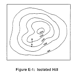

Match the topographic map to its profile picture.


Which of the following is a satellite that provides information about the ocean?
LandSat Satellite
Topex/Poseidon Satellite
Sea Beam
GPS/GIS
Which of the following uses sonar to map the ocean floor?
Sea Beam
LandSat
Topex/Poseidon
GPS/GIS
Which of the following is a system of satellites and determine your location?
Sea Beam
LandSat
Topex/Poseidon
GPS/GIS
How many km separate Montreal, Canada from Ayacucho, Peru.
Montreal is 45° N, 74° W and Ayacucho is 13° S, 74° W
1000 km
3552 km
6438 km
5000 km
The study of map making.
Remote Sensing
Cartography
Equator
Prime Meridian
Imaginary line that separates the Earth into E and W Hemisphere
Remote Sensing
Cartography
Equator
Prime Meridian
Technology that allows us to study the Earth.
Remote Sensing
Cartography
Equator
Prime Meridian
Imaginary line that separates the Earth into the E and W hemisphere.
Remote Sensing
Cartography
Equator
Prime Meridian

