Worksheets
Marine Biology Chapter 2 test
Total questions: 70
Worksheet time: 2hrs 50mins

This World War II technology allowed Dr. Hess to collect data on the age of the ocean floor. This data provided evidence for:
Continental Drift
Einstein's Theory of Relativity
The Doppler Effect
The Theory of Evolution
What was the name of the supercontinent?
The world
Pangea
Laurasia
Gondwana

What words describe M? choose all
deep ocean trench
mid ocean ridge
sea floor spreading
subduction

The diagram shows the magnetic polarity (they look like zebra stripes) of the seafloor at the Mid-Ocean Ridge. Which of the following statements is true about the magnetic polarity pattern of the ridge?
Stripes of normal polarity and reversed polarity DO NOT alternate across the ocean bottom.
Stripes form mirror images (are symmetrical) on either side of the mid-ocean ridges
Stripes form different images on either side of the mid-ocean ridges
there is not a pattern that is created

Oceanic crust (sea floor) is destroyed at this boundary.
Convergent Oceanic
Divergent Oceanic
Convergent Continental-Continental
Divergent Continental
When two continental plates converge (collide) what type of crustal feature is formed?
Mid Ocean Ridge
Subduction Zone
Rift Valley
Folded Mountains
What is the 'magic' that is happening in the upper mantle that helps move the 'lithospheric plates'?
Convection
Subduction
Seafloor Spreading


What geologic feature/event are you most likely to find at a transform boundary?
Earthquakes
Volcanoes
Mountains
Rift Valleys

What is the correct order (starting from the surface) of Earth’s layers?
crust, outer core, inner core, mantle
mantle, outer core, inner core, crust
crust, mantle, outer core, inner core
outer core, inner core, crust, mantle

Most geologists think that the movement of Earth’s plates is caused by _______
convection.
continental drift.
subduction.
conduction.

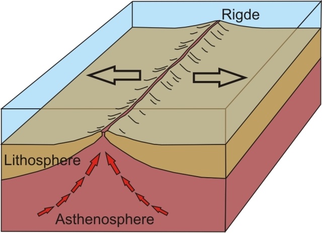
Below is a picture of sea-floor spreading. How are the ocean crusts moving?
Converging
Diverging
Sliding
No movement

What are Tectonic Plates?
A continent
The plates you serve food on
The Plates underground only
The Plates that include and move the Continents

What is Pangea?
the name of a German scientist
the name of the super-continent that existed millions of years ago
another name for continental drift
the name of an ancient fossil

What are the two types of crust?
continental and oceanic
ocean and basin
lower and upper
thick and thin
In some areas of the world, like California and Japan, earthquakes are a common occurrence. How can this best be explained?
The strong ocean currents are undermining both areas causing earthquakes.
Both areas are located near the edge of the Pacific Ocean, the unstable sand causes earthquakes.
Both areas are subjected to strong ocean wind and waves that causes earthquakes.
Both areas are on the boundary of active plates, the motion of the plates causes earthquakes.
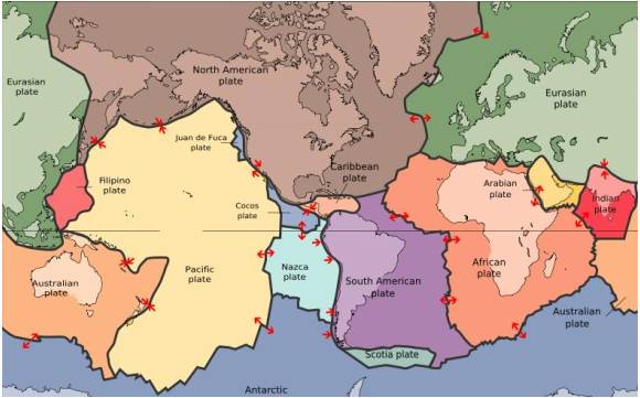
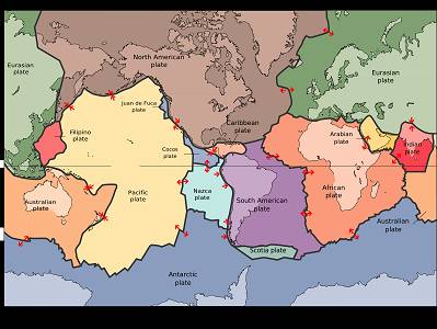
The map in the picture shows tectonic plate boundaries. This map would be useful in predicting the location of future
droughts
hurricanes
earthquakes
tornadoes
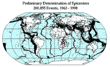
Earthquake epicenters (center of where the earthquakes started) were mapped for a 35 year period in the diagram above. The black dots indicate these epicenters. The black dots appear along what feature on Earth?
hot spots
plate boundaries
rift zones
sea floor spreading
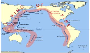
The image shows the Pacific Ring of Fire, a region of high tectonic activity. What evidence supports the theory that the tectonic activity of the region is due to the subduction of tectonic plates?
The region is bound by many oceanic trenches.
North America seems to be colliding with Asia at the north of the ring.
The region is dotted by volcanoes and experiences major earthquakes and tsunamis.
The landmasses look like they would fit together like the pieces of a jigsaw puzzle.
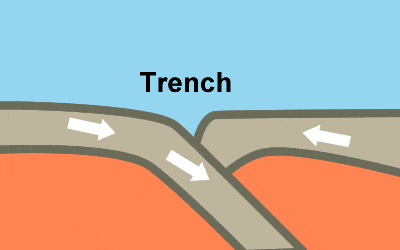
The Marianas Trench, where the Pacific Plate descends under the leading edge of the Eurasian Plate, is the deepest sea floor in the world. These ocean trenches form when two oceanic plates collide
and the older, less dense of the two plates rides over the edge of the older plate.
when convection currents in the mantle force the older plate downward.
and the younger, denser of the two plates, rides over the edge of the older plate.
and the plates are approximately the same age and density.


This theory states that Earth's crust is divided into large pieces that float on the mantle.
The Theory of Crust Motion
The Theory of Plate Tectonics
The Theory of Past Tectonics
The Theory of Plate Technicalities

Iceland [in yellow on the map] is located in the middle of the Atlantic Ocean. Geologists consider it a fascinating place because of all the volcanoes, geysers, and hot springs found there! It is an excellent location for geothermal energy use. Use the tectonic map to explain why it is such an active place for geology.
Iceland sits above a convergent boundary.
Iceland sits above a divergent boundary.
Iceland sits above a transform boundary.
Iceland is at a subduction zone
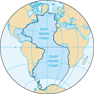
The following are oceans according to size
Pacific, Atlantic, Indian, Arctic, Antarctic
Pacific, Indian, Atlantic, Arctic, Antarctic
Atlantic, Pacific, Indian, Antarctic, Arctic
Pacific, Atlantic, Indian, Antarctic, Arctic
There are _____ oceans basins in the world
4
6
5
9

The Earth's outermost thinnest layer
crust
continental crust
oceanic crust
continental slope

The land we walk on, made mostly of granite
crust
continental crust
oceanic crust
continental shelf


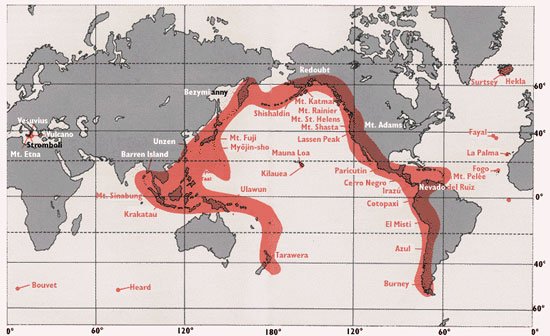
Which region in CA has Volcanoes that were active most recently?
North
South
Central
Catalina Islands
Which type of evidence was NOT used by Alfred Wegener to support his continental drift hypothesis?
Similar mountain ranges found on the eastern side of South America and the western side of Africa.
Identical fossils found on different continents.
Erosion and Weather appears on Mountain Ranges across the world.
Glacial erosion found in Australia India,and Africa.
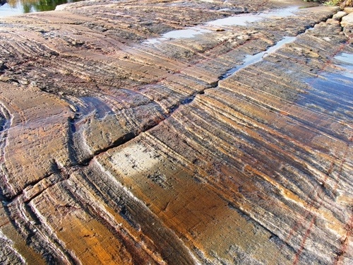
Coal is an example of climate change evidence because...
it is found in tropical areas today so it used to be near the equator
it is found in swampy areas today so the area used to be near the poles
it is found in cold areas today so it used to be closer to the equator
coal is not an example of climate change

This picture is an example of which type of evidence?
matching fossil
matching land formation
climate change
memorial movement

This picture is an example of which type of evidence?
matching fossil
matching land formation
climate change
memorial movement

This picture is an example of which type of evidence?
matching fossil
polar wandering
matching land formation
memorial movement
How does evidence of glaciation in Africa support the Theory of Continental Drift?
It shows that the continents must have been in a different location (Polar Wandering).
It doesn't.
I shows that it was colder at the equator in the past.
It shows that it was warmer at the equator in the past.

What are the remains of organism noticed by Wegener that are found the same in two continents?
Leaves and flowers
Ice and mountains
Plants and animals
Dinosaurs and reptiles

Which of the following best describes Wegener's continental drift ideas?
Hypothesis: There was data to support the idea but more information was needed to build it into a scientific theory.
Theory: It was an early idea of Wegener's but it didn't yet have any evidence to support it.
Theory: It was a well supported idea that explained many things. No additional information was needed (it just needed time for people to accept it).
Hypothesis: It was an educated guess that Wegener made based on maps, but he hadn't yet collected experimental data.
Tectonic plates consist of
continental crust.
mesosphere.
both continental and oceanic crust.
oceanic crust.
Tectonic plates “float” on
the lithosphere.
the mantle.
the ocean.
the asthenosphere.

South America and Africa look to fit together like a puzzle
does not support the theory of Pangaea
does support the theory of Pangaea

Fossils can also give evidence for a Pangaea theory
True
False
The 2004 Indian Ocean tsunami was caused by a shift in two plates that pushed one section of the sea floor under another section of the sea floor by 5 meters. What type of boundary is this?
divergent
convergent
transform
metamorphic

Find the Nazca and the South American Plate. This is an example of two plates converging. The denser oceanic plate (Nazca) moves under the continental plate (SouthAmericanPlate). What features are likely found here?
rift valleys
volcanoes
mid-ocean ridges
ocean basins

The Indian Plate (far right of plate picture) converges with the Eurasian Plate. When two continental plates converge what crustal feature is expected to form?
Rift Valley
Volcanoes
Mountains
Ocean Basin

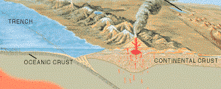
These are the Aleutian Islands in Alaska where the 7.8 Magnitude Earthquake occurred in early October 2020. There was a threat of a tsunami. The Aleutian Islands are in a ____________ zone.
Safe
Sea Floor
Divergent
Subduction

NASA claims asteroid discovered 170 years ago could be worth $10,000 quadrillion.
16-Psyche contains nickel and iron, just like the _______ core of Earth. This finding is evidence of the formation of Earth during the ___________ _____________.
Inner, Natural Selection
Outer, Big Bang
Inner, Plaster Tectonics
Inner, Big Bang