
 Worksheets
Maps and Globes Quiz
Total questions: 50
Worksheet time: 26mins
A ___________ tells the reader what the map is illustrating.
title
symbols
labels
colors


The red question mark is located to the _________ of the compass rose.
East
West

The red question mark is located to the _________ of the compass rose.
North
South

The red question mark is located to the _________ of the compass rose.
North
South

The red question mark is located to the _________ of the compass rose.
Southwest
Southeast

The red question mark is located to the _________ of the compass rose.
Northeast
Northwest

The __________ directions are north, east, south, and west.
cardinal
intermediate

A flat drawing that shows all or part of the Earth's surface
latitude
globe
map
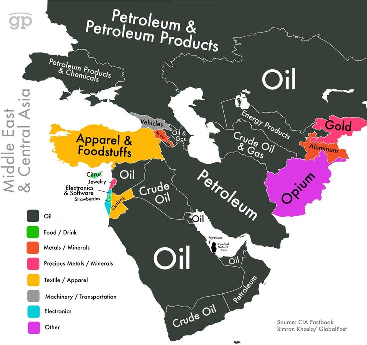
A map whose purpose is to show natural resources is what kind of map?
political map
physical map
thematic or special purpose map
inset map

A map emphasizing natural features such as highlands, lowlands, rivers, and deserts is what kind of map?
political map
physical map
thematic or special purpose map
inset map

A map (usually in a corner of a smaller scale map) that shows an area in more detail, or in larger scale is an __________________ map.
thematic or special purpose
political
inset
physical
What type of map is usually focused on man-made features, like borders?
Political
Physical
Thematic
What type of map is usually focused on elevation?
Political
Physical
Thematic

The map is?
Physical
Political
Thematic

The map is?
Physical
Political
Thematic

The map is...(ignore the inset map)
Political
Physical
Thematic

The map is...
Political
Physical
Thematic

The map is...
Political
Physical
Thematic

The map is...
Political
Physical
Thematic

The map is...
Political
Physical
Thematic

The map is...
Political
Physical
Thematic

The map is?
Thematic
Physical
Political

half of a sphere; which refers to half of the Earth is called a ___________________.
hemisphere
circle
full-sphere
quarter-sphere


Which hemisphere is shaded blue?
northern
southern
eastern
western

The Equator divides Earth into which two hemispheres?
northern and western
northern and southern
eastern and western
southern and western

The Prime Meridian and International Date Line divide the Earth into which two hemispheres?
northern and western
northern and southern
eastern and western
eastern and northern

Imaginary lines on a map that run north and south (vertical) are called ______________ lines.
latitude
longitude

Imaginary lines on a map that run east and west (horizontal) are called _______________ lines.
latitude
longitude

0 degrees longitude; an imaginary line that runs up and down through the United Kingdom is the _______________
Prime Meridian
Equator
International Date Line

180 degrees longitude; an imaginary line that runs up and down through the Pacific Ocean is the ___________________________
International Date Line
Equator
Prime Meridian

Zero degrees latitude is called the _____________?
south pole
equator
prime meridian
north pole
The two imaginary lines of latitude closest to the equator are called the __________ and the ____________.
Arctic Circle and Antarctic Circle
parallels and meridians
International Date line and Prime Meridian
Tropic of Cancer and Tropic of Capricorn

Lines of latitude are also called?
parallels
meridians

tropics
area near equator where sun is directly overhead at some point during the year
North Pole
hemisphere
South Pole


Africa is located in the:
Northern, Eastern, & Southern Hemispheres
Northern, Eastern, & Western Hemispheres
Northern, Southern, Western, & Eastern Hemispheres

North America is located in the:
Eastern & Southern Hemispheres
Northern & Western Hemispheres
Northern & Eastern Hemispheres


Which city lies between 90°W and 95°W?
Charleston
Little Rock
Atlanta
New Orleans

Which continent is located at...
60°W, 20°S
Africa
South America
Europe


Which STATE is located at...
45°N, 120°W
WA
OR
UT
ND

100°W, 48°N

