
 Worksheets
FOSS Soils, Rocks, and Landforms Unit
Total questions: 67
Worksheet time: 48mins

Which rapid change does this picture show?
landslide
earthquake
volcanic eruption
heavy snowfall
Volcanic eruptions are a slow or rapid change?
rapid
slow

Growing tree roots are a slow or rapid change?
rapid
slow
Chemical weathering is a slow or rapid change?
rapid
slow
Physical weathering is a slow or rapid change?
rapid
slow
Earthquakes are a slow or rapid change?
rapid
slow
Flash floods are a slow or rapid change?
rapid
slow
Volcanic eruptions create new land by adding ____.
new rock to Earth's surface
gases to the air
heat to the soil on Earth's surface
water vapor to the air

Is this picture a slow or rapid change?
Rapid
Slow

Is this picture a slow or rapid change?
Slow
Rapid
Pieces of rocks blown away by the wind is an example of ________.
erosion
weathering
deposition
Rock broken into smaller bits is an example of ________.
erosion
weathering
deposition
Water carries rock pieces away from a canyon is an example of ________.
erosion
weathering
deposition
Pieces of rocks settle in a new location is an example of ________.
erosion
weathering
deposition
A river flows into the ocean. Earth materials are deposited over a wide area. Which landform is likely to form?
Alluvial Fan
Delta
Valley
Mountain
Which factor causes particles of earth material to settle sooner when they are traveling down a river?
Large particle size
A steep slope
Water that moves quickly
A large amount of flowing water

How far did the earth materials travel in Table A?
45 cm
20 cm
35 cm
40 cm

How far did the earth materials travel in Table B?
45 cm
20 cm
35 cm
40 cm
Which fossil provides evidence that water once covered the area a long time ago?


How is the stream table useful in studying erosion and deposition?
It is model and models do not help us in the real world.
It shows how earth materials move and deposit in a shorter time.
Rivers and landforms are formed by Earth and cannot be represented.
It shows only how clay moves.
Soil forms by ________.
broken rocks mixing with decaying plant matter
rocks rubbing together
humans
Earth's rotation
Why are soils different in one place than in another place?
The amount of erosion and deposition depends on the amount of wind and water in certain areas, plus the amount of humus.
Each place has its own rocks and rocks can't travel.
Water is not strong enough to move rocks, so soil stays the same all the time.
Deposition only happens after flooding and erosion can only happen after it rains really hard.
Any natural resource that makes up Earth, including rocks, air, and water.
earth materials
conglomerate
physical weathering
chemical reaction
A form of precipitation containing acid, which forms when carbon dioxide gas in the air dissolves in water droplets is?
calcite
chemical weathering
physical weathering
acid rain
Rocks can break into smaller pieces by
physical and chemical weathering.
weathering.
only physical weathering.
only chemical weathering.
Soil with a lot of silt and clay is usually found
near a river delta.
near a stream.
in a desert.
in a forest.
Soil with a lot of humus is usually found
in a forest.
in the desert.
in a river delta.
by a mountain.
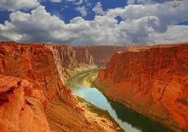

What land form is this?
Delta
Mesa
Mountain
Glacier

What land form is this?
Glacier
River
Plain
Mountain Range

What landform is this?
Desert
Plateau
Fjord
Plain

What landform are these?
Continents
Mountains
Oceans
Deserts

Study the diagram of layers of rock in the Grand Canyon. Which statement about the layers below is true?
Kiabab Formation is the most recent.
Bright Angel Shale is the most recent.
Supai Group is the oldest.
Hermit Shale is the oldest.

Think about the stream table that was shown in class. If it was a real river and lake, which symbol would most likely be the clay?
-
+
*
Think about the stream table that was shown in class. If it was a real river and lake, which symbol would most likely be the sand?
-
+
*

What type of weathering most likely caused this arch style landform?
Tree roots
Acid rain
Freezing and thawing
Sand blown by the wind

What type of weathering most likely caused this hoodoo landform?
Tree roots
Acid rain
Freezing and thawing
Sand blown by the wind

What type of weathering most likely caused the cracks in the rocks?
Tree roots
Acid rain
Freezing and thawing
Sand blown by the wind
Which is a list of renewable natural resources?
Sun, wind, water, animals
Coal, natural gas, petroleum, minerals

Which statement below best describes the weathering of these two different places.
Chemicals in the water dissolved parts of the rocks.
Sand blown by the wind weathered the rocks by breaking them into smaller pieces.
Plants grew in cracks and caused the tiny holes in the rocks.

Study the image. Find Number 1. Which rock sizes would probably be found here?
Boulders, cobble and pebbles
Sand, silt, and clay
Pebbles, gravel, sand

Which slow land changing events caused these sand dunes?
The river valley dried up and wind blew sand into piles.
Floods made water flow and then sand piled up.
A nearby volcano erupted and then piles of sand were deposited.
A moving glacier deposited the sand in plies.
Study the image. Find Number 4. Which rock sizes would probably be found here?
Boulders, cobble and pebbles
Sand, silt, and clay
Pebbles, gravel, sand

Study the image. What fast land changed caused it?
Earthquake
Flood
Landslide

Study the image. What rapid land change caused the fence to become disconnected?
Earthquake
Volcano
Flood
Landslide

Which side of the hill would you climb a greater elevation to get to the top?
left
right
both sides are the same elevation
there is no way to know unless you climb it
Which side of the hill has a steeper slope?
left
right
both sides are the same elevation
there is no way to know unless you climb it

Which side has a steeper slope?
A
B
They are both the same.
There is no way to know.
Which side has a gradual slope?
A
B
They are both the same.
There is no way to know.

Which map would a hiker need to measure elevation?
A
B

What is the elevation of point A, the peak?
about 700 meters
about 200 meters
about 400 meters
about 90 meters

Look at the picture. Which location would water be moving the fastest?
Mountain stream
Pond
River
Lake
Look at the picture. Which location has the steepest slope?
Mountain stream
Pond
River
Lake
Which resource below is a renewable resource?
air
coal
gasoline
natural gas
Which resource below is a renewable resource?
animlas
coal
minerals
natural gas
Which resource below is a renewable resource?
wind
coal
minerals
natural gas
Which resource below is a renewable resource?
soil
petroleum
minerals
natural gas
Which resource below is a nonrenewable resource?
soil
solar
minerals
animals
Which resource below is a nonrenewable resource?
soil
wind
coal
trees
Which resource below is a nonrenewable resource?
air
water
natural gas
trees
What should engineers, who build tall buildings in cities, take in consideration if the city is in an earthquake prone area?
Design buildings with foundations to absorb the earthquake's energy.
Design building minimally and build with the cheapest materials possible.
Design a way for earthquakes to stop happening.
Design buildings from what the neighbors want to see.

Hiker 1 stars at West and hikes to 283 m.
Hiker 2 starts at East and hikes to 283 m.
True or false: the distance walked for Hiker 1 will be greater?
True
False
Hiker 1 stars at West and hikes to 283 m.
Hiker 2 starts at East and hikes to 283 m.
True or false: the distance walked for Hiker 2 will be greater?
True
False
Hiker 1 stars at West and hikes to 283 m.
Hiker 2 starts at East and hikes to 283 m.
True or false: the distance walked will be the same for both hikers?
True
False
Hiker 1 stars at West and hikes to 283 m.
Hiker 2 starts at East and hikes to 283 m.
True or false: the elevation change will be the same for both hikers?
True
False
Hiker 1 stars at West and hikes to 283 m.
Hiker 2 starts at East and hikes to 283 m.
True or false: the elevation change will be greater for Hiker 1?
True
False
Hiker 1 stars at West and hikes to 283 m.
Hiker 2 starts at East and hikes to 283 m.
True or false: the elevation change will be greater for Hiker 2?
True
False

