
 Worksheets
RFMS Science: CSA 2 Review 2024/2025
Total questions: 109
Worksheet time: 3hrs 37mins
Which condition will most likely lead to the formation of winds on Earth?
uneven heating of Earth’s surface
geothermal activity
the shifting of tectonic plates
the revolution of Earth around the Sun
How are air temperature, density, and the movement of air related?
Cold air is more dense than warm air, so it rises to create a conduction cell.
Cold air is less dense than warm air, so it sinks to create a convection cell.
Warm air is less dense than cold air, so it rises to create a convection cell.
Warm air is more dense than cold air, so it sinks to create a conduction cell.
What causes differences in air pressure around the Earth?
Cold air rises at the equator, and warm air sinks at the poles.
Warm air rises at the equator, and cold air rises at the poles.
Warm air sinks at the equator, and cold air rises at the poles.
Warm air rises at the equator, and cold air sinks at the poles.
Explain the role of density in the movement of deep currents.
Cold, high salinity deep current water is less dense than warm, low salinity surface current water. As warm water sinks, cold water will move in to take its place, creating a circular movement called a convection current.
Cold, high salinity deep current water is more dense than warm, low salinity surface current water. As warm water rises, cold water will move in to take its place, creating a circular movement called a convection current.
If a cool surface current flows along a coastline, what effect might it have on the climate in that area?
In general, it will bring warmer temperatures in the summer and milder temperatures in the winters
In general, it will bring cooler temperatures in the summer and milder temperatures in the winters
In general, it will have no long term effect on climate in that area.
In general, it will bring cooler temperatures in the summer and colder temperatures in the winters
Why would a location on the ocean (coastline) have cooler temperatures than a location that is land-locked (no ocean access), even though both locations are at the same latitude? Choose TWO.
The coastline city will have consistently milder temperatures (mild summers and winters) due to the land and sea breezes and currents.
The city that is land-locked will have less consistent temperatures (hot summers and cold winters) because they do not have any impact from the ocean and the ocean's moisture.
They would not have a temperature difference.
Cities that are land-locked are impacted by the ocean's moisture and cities that are by the ocean are not impacted by the ocean's moisture.
What is the fundamental cause of air circulation in Earth's atmosphere?
ocean currents
Earth's gravity
energy from the sun
Earth's magnetic field

Which climate zone receives the least amount of sunlight, and what is the result of that?
Temperate, warm and cool climates
Tropical, more heat and sunshine
Polar, less heat and sunshine
Regions closest to ________________ tend to have warmer year-round climates.
Forest Fires
South Pole
North Pole
the Equator

What does "latitude" refer to?
the distance away from the Equator
how much rain a place gets
how high up a mountain a place is
the number of seasons a place gets

The higher the altitude of a city, the _______________ the temperatures are.
hotter
colder
more consistent
weirder
The sun heats the surface of the Earth unevenly, resulting in atmospheric convection currents. What is created due to convection cells?
Wind
Clouds
Stars
Rain
Warm ocean currents are most likely to be located towards the surface of the ocean because
Winds press the cold water down
Warm water is less dense and rises
Cold water is less dense and sinks
Within a land breeze or a sea breeze, how does air pressure move?
North to South
High pressure to low pressure
Low pressure to high pressure
East to West

The Gulf Stream is a warm water current that begins in the Gulf of Mexico. A diagram of the Gulf Stream (gray arrow) is shown.
Which best describes the movement of the Gulf Stream?
Cold currents carry cold water from the poles to the equator.
Warm currents carry cold water from the tropics towards the poles
Warm currents carry warm water from the tropics towards the poles
Cold ocean currents are most likely to be located deeper in the ocean because
Winds press the cold water down
Warm water is more dense and rises
Cold water is more dense and sinks
Below is the process for creating wind. Fill in the blank with the appropriate step.
Step 1) ___________ --> Step 2) air cools in upper atmosphere and sinks --> Step 3) air currents (wind) are formed
Global winds
Uneven heating of the Earth
Coriolis effect
A hurricane spins clockwise in the Northern Hemisphere due to the rotation of the Earth. This effect is called:
Continental deflection
Global winds
Coriolis effect
Hydrologic cycle

The drawing shows a sea breeze. When is this wind pattern most likely to occur?
During the night when the surface of the sea cools faster than the land
During the day when the land heats faster than the surface of the sea
During the day when the sea heats faster than the surface of the land

The drawing shows a land breeze. When is this wind pattern most likely to occur?
During the night when the surface of the sea cools faster than the land
During the day when the land heats faster than the surface of the sea
During the night when the surface of the land heats faster than the sea

Use the diagram. At which point is the water in the current the warmest?
1
2
3
4
Use the diagram. At which point is the water in the current the coolest?
1
2
3
4
Which best describes how continental deflection happens in nature?
A current changes direction due to hitting a land mass
Winds cause the surface of the ocean to create currents
The Earth’s rotation causes currents to moved in curved paths
Warm air travels from the ____________ and travels to the ___________ as it cools.
Poles, Equator
North Pole, South Pole
Equator, Poles
A tumbleweed is a plant that detaches itself from the ground when the wind blows. What causes the wind to blow?
Uneven heating of the Earth’s atmosphere
Movement of plate tectonics
The moon’s gravity
What are the factors that create deep currents?
Salinity, temperature
Global winds, Coriolis Effect, Continental Deflection
Salinity, global winds
Temperature, Coriolis effect
What are the factors that create surface currents?
Salinity, temperature
Global winds, Coriolis Effect, Continental Deflection
Salinity, global winds
Temperature, Coriolis effect
How do weather and climate differ?
Weather is the average conditions of an area over a long period of time, and climate is the day-by-day predictions of an area.
Climate and weather do not differ.
Climate is the average conditions of an area over a long period of time, and weather is the day-by-day predictions of an area.
Why do regions closer to the Equator tend to have warmer climates?
Climates near the Equator receive indirect sunlight, which causes the climates to be cooler.
Climates near the Equator receive direct sunlight, which causes the climates to be cooler.
Climates near the Equator receive direct sunlight, which causes the climates to be warmer.
Climate temperature is affected by:
Ocean Currents and Distance from Large Bodies of Water
Latitude, Altitude, and Ocean Currents
Latitude, Altitude, Distance from Large Bodies of Water and Ocean Currents
What is topography?
a graph showing all the different topos
A map of different mountains in a mountain range that share watersheds
The shape of the land determined by the elevation
What is the climate of the top of a mountain like as compared to the bottom of the mountain?
warmer
cooler
drier
wetter
The temperature of an ocean current _____ affect the climate of the land nearby.
does
does not
How does the ocean affect climate in the summer and winter? Select two!
The ocean warms nearby land in the summer.
The ocean cools nearby land in the summer.
The ocean warms nearby land in the winter.
The ocean cools nearby land in the winter.
Which of the following is a TRUE statement?
Weather is day to day events of precipitation and temperature, but climate is week to week events.
Weather and climate are the same thing.
Weather is day to day events of precipitation and temperature, but climate is the average, year-after-year conditions.
Weather refers to the events of precipitation and temperature, but climate only refers to temperature.

Which box below shows a more dense object?
Left
Right
What is the equator?
An imaginary line that divides the world into two parts
A continent in the northern hemisphere
A continent in the southern hemisphere
A line that separates the oceans
Which statement correctly defines wind?
Wind is the movement of air from areas of low pressure to areas of high pressure
Wind is the movement of air to a colder area in the atmosphere.
Wind is the movement of air from areas of high pressure to areas of low pressure.
Wind is the movement of air pushed around and bouncing off Earth's surface.
What causes wind?
differences in air pressure
differences in gravity
difference in oxygen
differences in the thermosphere
Weather systems in the Earth's atmosphere are due to
conduction
convection
radiation
What causes differences in air pressure?
even heating of the Earth
Even cooling of the earth
uneven heating of the earth
global warming
The area of Earth that receives the most solar radiation is the equator. Why?
Sunlight reflects off water more powerfully at the equator.
Near the equator, sunlight strikes Earth's surface at a low angle.
In latitudes near the equator, sunlight strikes Earth's Surface at a nearly 90 degree angle year round.
At latitudes near the North Pole and South Pole, sunlight strikes Earth's surface at a low angle. This causes which effect?
The poles receive more energy than anywhere else on Earth.
There is more sunlight per unit of surface area.
Santa must use lights all day and night in the North Pole from June to September.
The poles receive very little energy per unit of surface area.

Why is the Equator warmest?
Because it is closest to the sun.
Because it receives the most direct sunlight
Because no clouds form here.
Because it is far from the sun

Which location would receive more intense, direct sunlight?
A
B
Which location would receive less intense, less direct sunlight?
A
B
A measurement of distance from the equator in degrees north or south is
attitude
aptitude
longitude
latitude

Why does the area around the equator stay the same temperature all year?
The equator rotates slower than the poles
The equator remains the same distance from the sun.
The equator always receives direct sunlight.
The equator has 18 hour days.
What is the source of energy that heats our planet's atmosphere and oceans?
the weather
the wind
the Sun
the Earth's core
Why does the Earth experience unequal heating?
The oceans are not equally distributed around the Earth.
The Earth's revolution brings it closer to the Sun at certain points during the year.
The curvature of Earth.
The atmosphere is not equally distributed around the Earth.


Students measured & recorded the density of 4 samples. Using the density column & the data table shown, which of the samples will float on top?
Sample A
Sample B
Sample C
Sample D
What kind of weather is a low-pressure system most likely to bring?
Clear weather
Hot, sunny weather
Clouds and possible storms
Light breezes
Which instrument measures temperature?
sling psychrometer
thermometer
barometer
anemometer
Which instrument measures air pressure?
sling psychrometer
hygrometer
barometer
anemometer
At which humidity is it most likely to rain?
50%
20%
77%
99%
What kind of weather is a high-pressure system most likely to bring?
Clear, sunny weather
Hot, sunny weather
Precipitation (rain and snow)
Light breezes
When a cold air mass wedges its way under a warm air mass a ____________ occurs.
warm front
cold front
stationary front
polar front
When a warm air mass moves up and over a cold air mass, a ________ occurs.
cold front
warm front
stationary front
tropical front
Which type of air is less dense?
warm air
cold air
polar air
Which type of air is more dense?
warm air
cold air
tropical air
In areas of _________, air is rising and moist leading to cloudy skies.
high pressure
low pressure
warm front
cold front
In areas of _____________ air is sinking and dry leading to clear skies.
low pressure
high pressure
warm front
cold front
When two air masses collide, a boundary forms between them called a ________________.
weather front
current
pressure zone
weather forecast
________________ have consistent temperature, moisture, and pressure.
air masses
weather fronts
atmosphere
convection
A strong thunderstorm followed by clear skies and a drop in temperature is the result of a _____________ moving through.
warm front
cold front
air mass
pressure front
Gentle rain and cloud cover followed by an increase in air pressure and temperature is the result of a ______________ moving through.
warm front
cold front
air mass

This type of front happens when a cold air mass quickly moves forward, pushing warm air up into the atmosphere quickly. In this type of front one can expect to experience stormy weather and thunder.
cold front
warm front
stationary front
tropical front
Which type of air is more dense?
Hot air
Cold air
Warm Air
The moisture near the coastal regions comes from the __________. There is usually a lot of wind there.
air
air pressure
ocean
wind
climate
A high pressure system means we might have this weather.
Snow blizzard
Sunny and dry
Rain storm
Tornado
Where do MARITIME air masses form?
Over water
Over land
Where do CONTINENTAL air masses form?
Over water
Over land
Describe a tropical air mass.
Dry
Wet
Cold
Warm
What types of air masses would be colder?
Maritime
Continental
Polar
Tropical
Which is the best definition of an Air Mass?
A massive wind that can cause tornadoes, hurricanes, and thunderstorms.
A large accumulation of clouds that form as a result of condensation in the atmosphere.
A large body of air that has similar properties of the area where it forms.
A massive storm created by strong winds.

Look at the chart. What temperature would most likley recorded at
12 pm?
47
50
55
59
On a cold, cloudy day, the local weather forecaster predicts that a high pressure system will be moving into the area in the next 24 hours. Which weather conditions will this system most liely bring to the area?
stormy
sunny
snowy
hot
Which correctly compares low- and high-pressure weather systems?
a low-pressure system usually brings cool dry air and clear skies, while a high-pressure system brings clouds and precipitation
a low-pressure system usually brings warm dry air and clear skies, while a high-pressure system usually brings warm moist air and precipitation
a low-pressure system usually brings clouds and precipitation, while a high-[ressure system brings cool dry air and clear skies
a low-pressure system usually brings fiar weather and a high-pressure system usually brings stormy weather.
Jane wants to measure the amount of precipitation in her backyard for the month of January, Which weather instrument should Jane use?
barometer
rain gauge
thermometer
weather vane
Describe the process of predicting snowfall.
Predicting snowfall involves counting the number of polar bears in a region.
Meteorologists use tarot cards to predict snowfall.
Meteorologists analyze weather patterns, temperature, humidity, and air pressure using computer models to predict snowfall.
Snowfall is predicted based on the number of snowflakes seen in a crystal ball.


A cold front is approaching Minneapolis. What will happen to the air temperature?
stay the same
increase
decrease


Why does city "B" have clear skies?
It is in North America
There is not a front moving through city "B"
Clouds do not form in the West
It is located near a high pressure system


Cloudy/Overcast/Could become Stormy Weather




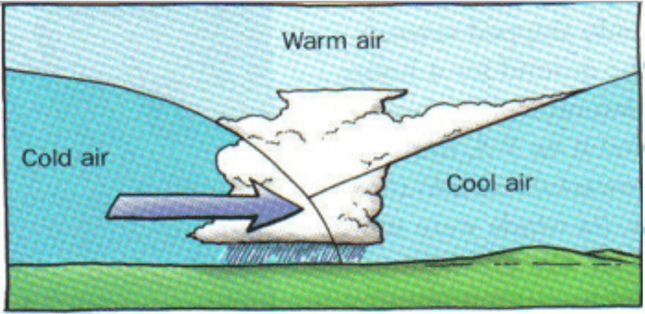
Name that front.
Cold Front
Warm Front
Stationary Front
Occluded Front

This symbol is used for what type of front?
cold front
occluded front
stationary front
warm front
What happens at an occluded front?
A warm air mass and cold air mass meet, but neither moves
Two cold air masses are on either side of a warm air mass
Cold, dense air pushes warm air upwards
Warm air catches up to cold air and slides over it
In science, what is a front?
A front is a boundary where air of different temperature and humidity meet.
A front is an area that is cold and frosty.
A front is an area of smooth, flat land.

Cold front

Warm front

Occluded front

Stationary front
If the measurement on a barometer is decreasing/dropping/going lower, this must mean that:
the pressure is decreasing, so we can predict the weather is going to get stormy
the pressure is decreasing, so we can predict the weather is going to be fair
the pressure is increasing, so we can predict the weather is going to get stormy
the pressure is increasing, so we can predict the weather is going to be fair
If the measurement on a barometer is increasing/rising/going up, this must mean that:
the pressure is decreasing, so we can predict the weather is going to get stormy
the pressure is decreasing, so we can predict the weather is going to be fair
the pressure is increasing, so we can predict the weather is going to get stormy
the pressure is increasing, so we can predict the weather is going to be fair
Locations that are at higher altitudes are warmer than places that are at a lower altitudes.
True
False
A city near a warm ocean current will have a __________ climate.
warmer
colder
moderate
temperate
The California ocean current comes by the Pacific Northwest after having been at the poles. This causes the climate off the coast of Oregon to be _______________.
warm
cool
Water heats up and cools down _________ slowly than land.
more
less

How does latitude affect the climate of an area?
The higher the latitude, the warmer the temperature.
The higher the latitude, the lower the temperature.
The higher the latitude, the more precipitation.
The higher the latitude the less precipitation.
Locations on a coastline (close to the ocean) will have what type of climates year-round?
More drastic temperature changes (hot summers, cold winters)
More moderate temperature changes (mild summers and winters)
Locations that are land-locked (further away from the ocean) will have what type of climates year-round?
More drastic temperature changes (hot summers, cold winters)
More moderate temperature changes (mild summers and winters)

