
MỚI
Cỡ chữ
 bảng tính
Plate Tectonics ES.7
Total câu hỏi: 42
Worksheet time: 30mins

The Juan De Fuca Plate diving beneath the North American plate is known as...
a divergent plate boundary
an island arc
a subduction zone
a transform plate boundary

When rocks bend due to stress, they sometimes break. This break where movement occurs is called a __________.
transform boundary
stress zone
convergent zone
fault

When two fault blocks move horizontally past each other at transform boundaries, this is called a ______________.

Earthquakes can occur at....
convergent boundaries
divergent boundaries
transform boundaries
all plate boundaries!

________ form in the middle of a tectonic plate over a hot spot.
mountains
volcanoes
continental rifts
trenches

Folded Mountains are created when....
Two continental plates collide
Two oceanic plates pull apart
An Oceanic plate subducts under a Continental Plate
Two continental plates pull apart

Where would the oldest rock on the ocean floor be found?
Mid-Ocean Ridges
At Rift Valleys
Deep Sea Trenches
All ocean rocks are the same age

When two oceanic plates move apart in a divergent boundary it forms...
Magnetic poles
Mid-ocean ridges
Ocean trenches
subduction zones

When two continental plates move away from each other in divergent boundaries it creates...
Rift Valleys
Ocean Trenches
Mid-Ocean Ridges
Subduction Zones

The San Andreas Fault zone in California is an example of _______.
an ocean-continent collision
a continental rift
a divergent plate boundary
a transform plate boundary

The Hawaiian Islands and the Emperor Seamount chain formed as a result of ________.
convergent plate boundary activities
hot spot activities
transform plate boundary activities
divergent plate boundary activities

Oceanic crust has a ________ composition and therefore is ________- than continental crust.
basaltic; denser
granitic; lighter
granitic; denser
basaltic; lighter

Where is the Ring of Fire located?
Atlantic Plate
Pacific Plate
Indian Plate
Antarctic Plate


subduction boundary

Geologists discovered Earth’s interior layers by _______.
estimating temperature inside earth.
directly looking under the many layers.
recording and studying seismic waves.
Drilling for rock samples

What type of plate boundary is pictured above?
convergent with subduction
divergent
transform
Convergent with collision

The movement of Earth’s plates is caused by _______
convection currents
continental drift
rifting & subduction
conduction

As you travel from the inner core to the crust, how would temperature, pressure and density of the layers change?
They would all increase
They would all decrease.
Nothing, the layers are made of the same material throughout
Temperature would decrease, but pressure and density would increase

The place where the earthquake is felt on the Earth's surface is called the...
Epicenter
Hypocenter (focus)
Surface
Crust
Which of the following is NOT a cause of an earthquake?

What is an instrument that detects and records waves produced by earthquakes? (This piece of equipment can measure the magnitude of an earthquake.)
Epicenter Triangulator
Fault detector
Seismic wave
Seismograph/ Seismometer


The place where an earthquake originates beneath Earth's surface ...
Epicenter
Focus
Underground
Crust

Karst topography is found in which Virginia province?
Costal Plains
Valley and Ridge
Appalachian Plateau
Piedmont
The presence of marine fossils in Virginia means that the area was once covered by_________.
Seawater
Glaciers
Mountains
Plants

Which young province is made of layers of clastic sedimentary rocks from clay, sand, and gravel deposits?
Appalachian Plateau
Valley and Ridge
Blue Ridge
Coastal Plain
The folding and faulting found in the rocks of the Blue Ridge Mountains of Virginia were created by -
collisions of continental plates
wave action of prehistoric ocean
the Coriolis effect
heating and cooling of the prehistoric atmosphere
The presence of many metamorphic rocks in Virginia is an indication that the area has been subjected to
intense heat and pressure
limited volcanic activity
deep ocean venting
massive solar bombardment

How was the Appalachian Plateau turned into mountains?
The erosion of rivers
continental collisions
volcanoes & earthquakes
subduction

This region west of the Fall line is best known for its valuable resources like kyanite and high quality slate:

Contains sandstone as old as 320 million years old
Coal beds can be found here
Coastal Plain

Wegener found fossils of ancient ferns on Antarctica, this shows
That some ferns can survive temperatures well below freezing
That humans put ferns on Antarctica millions of years ago
That Antarctica drifted from a warmer climate where plants could grow
That fossils can be formed in cold climates
What type of evidence was NOT used by Alfred Wegener to support his continental drift theory?
evidence from the shapes of continents
evidence from matching fossils
evidence from matching rocks & mountains
Volcanic arcs, earthquakes, & trenches are features of:
Convergent with Subduction
Convergent with Collision
Divergent boundaries
Transform/sliding boundaries
Volcanoes, earthquakes, mid-ocean ridges & rift valleys are features of:
Convergent with Subduction
Convergent with Collision
Divergent boundaries
Transform/sliding boundaries
Folded mountains & earthquakes are features of:
Convergent with Subduction
Convergent with Collision
Divergent boundaries
Transform/sliding boundaries
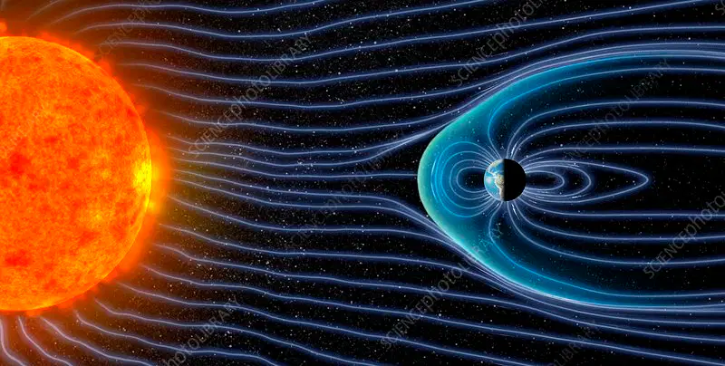
What is created by the Iron Core and Earth's Rotation?
Magnetosphere
Solar Winds
Convection Currents
Plate Movement

Where are the OLDEST rocks on the seafloor?
Near subduction zones
Farthest from the mid-ocean ridges
Near trenches
All of these locations
Where are the YOUNGEST rocks on the seafloor?
Near subduction zones
Near the mid-ocean ridges
Near trenches
At collision zones

