wayground logo

Free Printable Worksheets

Font size

S
M
L
XL
Worksheets

EARTH MOVEMENTS AND MAPS

Total questions: 43

Worksheet time: 40mins

Name
Class
Date
1.

How long does it take for the Earth to complete one full rotation around it's axis?

a)

24 hours

b)

12 hours

c)

6 hours

2.

If Earth was not tilted, what statement would be correct?

a)

The seasons are unaffected.

b)

The seasons are reversed.

c)

There are no seasons.

3.

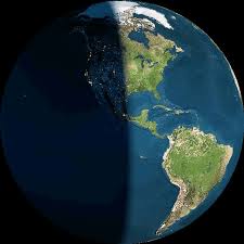
What happens to our day and night hours on December 21st (Winter Solstice)?

a)

Days are longer and nights are shorter.
b)

Days and nights are 12 hours.

c)

We probably have eclipses.

d)

Days are shorter and nights are longer.

4.

What happens to our day and night hours on June 21st (Summer Solstice)?

a)

Days are shorter and nights are longer.

b)

Days and nights are 12 hours.

c)

We probably have eclipses.

d)

Days are longer and nights are shorter.

5.
The spinning of an object on its axis is called______
a)
orbit
b)
rotation
c)
revolution
d)
tide
6.
Day and night is caused by the . . .
a)
revolution of Earth around the Sun
b)
orbit of Earth around the Moon
c)
rotation of earth on its axis.
d)
rotation of the Moon on it's axis
7.
Sunlight hits Earth’s surface most directly at the _______. Because of this, this area doesn't experience seasons.
a)
north pole
b)
south pole
c)
equator
d)
axis
8.
What is a revolution?
a)
standing still
b)
spinning in place about an axis
c)
bouncing to another object
d)
one object moving around another object
9.

As a calendar year only has 365 days, there is a _____________ every four years. We add an extra day to the month of February.

a)

Leap year

b)

Equinoxes

c)

Solstices

d)

Month year

10.

The seasons are...

a)

Winter, summer, autumn and hotter

b)

Summer, spring, tuna and snow

c)

Spring, summer, autumn and winter

11.
What city is located at 32 degrees south and 150 degrees east?
a)
Shanghai
b)
Sydney
c)
Durban
d)
Calcutta 
12.
Which continent is located completely north of the Equator and west of the Prime Meridian?
a)
Asia
b)
Europe
c)
North America 
d)
South America
13.
Which continent is completely south of the Equator and east of the Prime Meridian?
a)
Antartica 
b)
South America
c)
North America 
d)
Australia 
14.
What are the coordinates for the city of New Orleans? 
a)
30 degrees north and 90 degrees west
b)
60 degrees north and 30 degrees east
c)
30 degrees north and 120 degrees east
d)
35 degrees north and 70 degrees west
15.
Longitude lines run from north to south.
a)
True
b)
False
16.
Latitude lines go from east to west.
a)
True
b)
False
17.
What are the four MAIN directions on the Compass Rose?
a)
North, South, East, and West
b)
Northeast, Southeast, Northwest, Southwest
18.
What is the name of this line at 0 degrees latitude?
a)
Prime Meridian
b)
Equator
c)
North Pole
d)
South Pole
19.
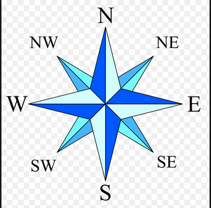
What is this object known as?
a)
map symbol
b)
map key
c)
map scale
d)
compass rose
20.
a)
The map show the lines of longitude.
b)
The map shows the lines of latitude.
21.
a)
The map shows lines of longitude.
b)
The map shows lines of latitude.
22.
Latitude and longitude are measured in ________.
a)
inches
b)
feet
c)
degrees
d)
grams
23.
What is the name of the line at zero degrees longitude?
a)
Equator
b)
Prime Meridian
c)
North Pole
d)
South Pole
24.

Location D is located at which coordinates?

a)

30oN, 90oW

b)

90oN, 30oW

c)

10oN, 40oW

d)

30oN, 90oE

25.
Which runs horizontally around the earth?
a)
Equator and lines of latitude
b)
Prime Meridian and lines of latitude
c)
Equator and lines of longitude
d)
Prime Meridian and lines of longitude
26.
Which runs vertically around the earth?
a)
Equator and lines of latitude
b)
Prime Meridian and lines of latitude
c)
Equator and lines of longitude
d)
Prime Meridian and lines of longitude
27.
North and South America are in what hemisphere?
a)
Northern
b)
Southern
c)
Western
d)
Eastern
28.
Europe, Asia and North America are in what hemisphere?
a)
Northern
b)
Southern
c)
Western
d)
Eastern
29.
The equator breaks the Earth into what two hemispheres?
a)
Eastern and Southern
b)
Northern and Southern
c)
Western and Eastern
d)
Northern and Western
30.
The Prime Meridian separates the Earth into what two hemispheres?
a)
Northern and Southern
b)
Western and Eastern
c)
Northern and Eastern
d)
Southern and Western
31.
Lines of latitude are also called  __________.
a)
hemispheres
b)
Parallels
c)
Meridians
d)
Tropics
32.
Lines of longitude are also called  ____________.
a)
Hemispheres
b)
Meridians
c)
parallels
d)
International Date Lines
33.

90 Degrees North.

a)

Equator

b)

Prime Meridian

c)

South Pole

d)

North Pole

34.
Which topographic map matches formation C?
a)
1
b)
2
c)
3
d)
4
35.
The height above sea level is called
a)
topographic
b)
contour
c)
elevation
d)
depth
36.
What are the curved lines on a topographic map called?
a)
contour lines
b)
contour intervals
c)
slope
d)
elevation
37.
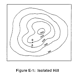
What is the contour interval on this map?
a)
100
b)
10
c)
15
d)
20
38.
How many peaks are on the map? (hill tops)
a)
4
b)
3
c)
2
d)
1
39.
It is steep on a topographic map where __________.
a)
lines are closest together
b)
a river flows into a lake
c)
contours bend
d)
contours are far apart
40.
Determine the contour interval:
a)
5 m
b)
10 m
c)
15 m
d)
20 m
41.
What do contour lines that are farther apart represent?
a)
waterfall
b)
steep area
c)
gentle slope
d)
river
42.

What is the gradient between points X and Y?

a)

40 m/km

b)

80 m/km

c)

100 m/km

d)

120 m/km

43.

A stream has a source at an elevation of 1,000 meters. It ends at a lake that has an elevation of 300 meters. If the lake is 200 kilometers away from the source, what is the average gradient of the stream?

Change in field value = ____________________

Distance = ___________

Gradient = ___________

a)

700 m

200 km

3.5 m/km

b)

800 m

200 km

4 m/km

c)

100 m

200 km

0.5 m/km

d)

1300 m

200 km

6.5 m/km